ALASKA and NORTHWESTERN CANADA - Drought.gov
←
→
Page content transcription
If your browser does not render page correctly, please read the page content below
ALASKA and NORTHWESTERN CANADA
Weather and Climate Highlights and Impacts, Sep - Nov 2019; Climate Outlook Jan - Mar 2020

                                                                                             1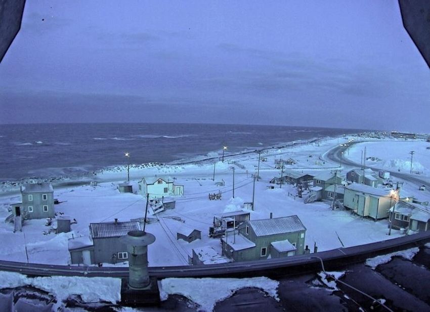
Sept – Nov 2019 Temperature Averages (°F/°C) and Anomalies (Above / Near Normal) Co-producing culturally relevant sea-ice climate products
A case study in western Canadian Arctic communities
In the spring of 2018, ECCC joined a partnership with the Marine Environmental Observation,
Prediction and Response (MEOPAR) to engage northerners on impactful weather to their way
of life/travel. In September 2019, along with the Canadian Centre for Climate Services (CCCS),
the project was expanded to include sea ice impacts on travel in the arctic. Scientists from the
University of Victoria, joined by representatives of Environment and Climate Change Canada
visited the hamlets of Sachs Harbour, Ulukhaktok, Tuktoyaktuk and Inuvik in the Northwest
Territories in September/October 2019. Kugluktuk, Cambridge Bay and Gjoa Haven visits are
scheduled for March 2020.
The focus of the trip was to strengthen relationships with arctic communities through
engagement and outreach activities with local residents. Activities included the sharing of local
weather and sea ice knowledge, the introduction of sea ice products currently available for the
Canadian arctic and discussions on how to best tailor those products to the needs of the
communities. Meetings were hosted in each community to share information on the project
and to learn from active hunters, mayors and elders about their way of life, traditions and
concerns. The sharing of knowledge highlighted the continued impact of hazardous weather
and thinning sea ice to Indigenous Peoples and northern communities.
The trip also allowed the MEOPAR/CCCS project to collaborate with local residents to
build capacity in understanding and interpreting weather and sea ice products and services.
Locally hired research assistants visited the University of Victoria and the Prairie and Arctic
Storm Prediction Centre in Edmonton, as part of a training and knowledge exchange
opportunity in February 2019. This partnership has provided two-way sharing of knowledge
between forecasters and Indigenous and northern communities.
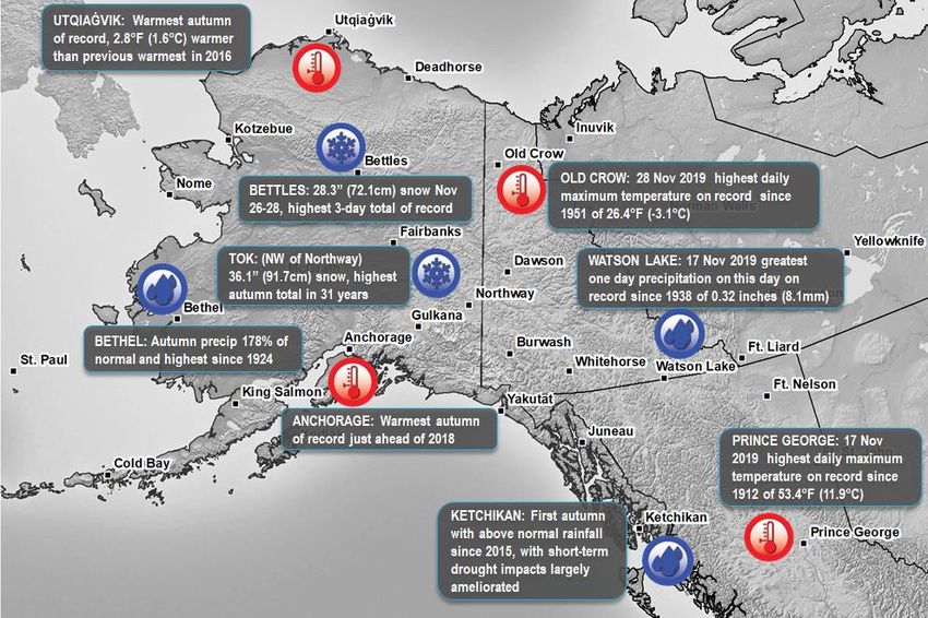
Sept – Nov 2019 Precipitation Totals (inches/mm) and Anomalies (Dry / Wet) Utqiaġvik 28 November 2019 Sea Ice Camera Photo at noon
There was very little sea ice this autumn at Utqiaġvik and record low sea
ice extent in the Chukchi Sea. Strong west winds on November 28
produced minor coastal flooding that closed roads.
2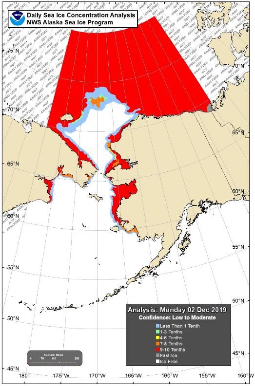
Antecedent Dry conditions, Low water and Low Hydro Generation Southern Alaska Autumn 2019 Drought Conditions
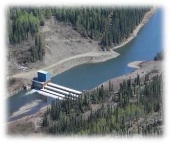
Photo of Mayo Yukon Dam, Photo credit: Yukon Energy
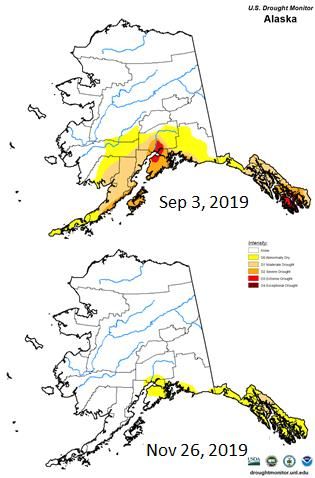
Autumn 2019 began with drought or abnormal dryness in southern Alaska,
stretching from the Alaska Peninsula in the west to the Panhandle in the east, as
shown in the image above. The repeated autumn storms brought a range of near
normal to much above normal precipitation to southwest and southcentral Alaska.
While this largely put an end to the drought conditions at low elevations, it was
warm enough on the Kenai Peninsula that the mountain snowpack was well below
normal at the end of November. Southeast Alaska also received significant rainfall
during what is typically the wettest time of year, which greatly helped to ease
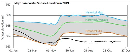
Mayo Lake surface water elevation in 2019 (black line) and historical levels. drought impacts by largely refilling many reservoirs used for water supply and
electric power production. The rain was frequent but generally not excessive during
A dry, hotter than normal, Spring and Summer in central Yukon created the pre-
the autumn, although minor flooding was reported in the Ketchikan area on
conditions that led to low lake water Levels persisting through the fall months in
November 13. However, overall dry conditions have been in place for a couple
Mayo, Yukon in 2019. The low water level will likely prevent electricity generation
years, and ecosystem services (e.g. fish flows) sensitive to long term precipitation
capacity unless precipitation raises the lake level above the minimum for
will require more rain and higher elevation snows to return to normal.
generation.
3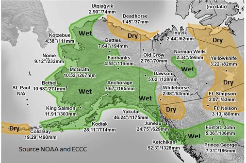
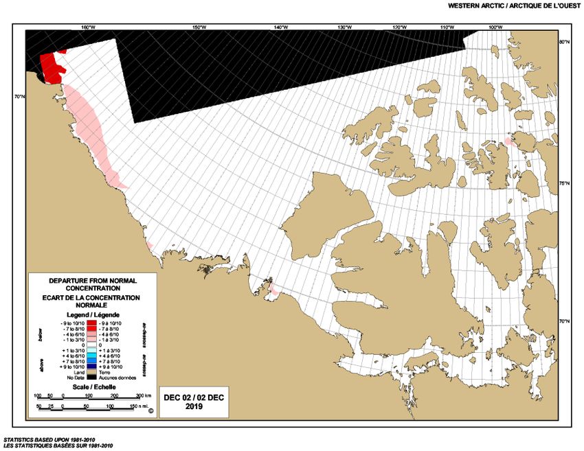
Sea Ice Conditions 2 December 2019 in the Chukchi and Beaufort Seas
Sea ice coverage around Alaska was exceptionally low this
autumn. The westernmost Beaufort Sea did not become
entirely ice covered until the second week of November, and,
overall, this was the second to latest ice-over date for the
Beaufort Sea in the 41-year satellite record. The Chukchi Sea
annual minimum ice extent was reached on September 17 but
only slowly increased thereafter, as open water persisted very
far north until late in October. Overall, the daily average sea
ice extent for autumn was only 23 percent of the 1981-2010
average. Bering Sea ice was minimal through October.
November saw more ice development near the Alaska coast
than in 2017 or 2018 but was still only about half of the 30-
year average. Since freeze-up began in September, the general
ice growth lagged significantly relative to the Canadian Ice
Service’s 30 year ice climatology (1981-2010). Overall, ice
growth was between 3 and 5 weeks later than normal, mostly
over the southern and western portion of the Beaufort Sea. By
early December, almost the entire region was expected to be
covered by ice; however, this year the ice coverage was about
6-7 weeks later than normal, albeit by about 6% below the
normal 97% ice coverage for December 2nd.
Temperature Outlook: Jan - Mar. 2020 Precipitation Outlook: Jan - Mar. 2020
A combined Canada-USA forecast model is used to provide a
temperature and a precipitation outlook for January to March 2020.
The temperature outlook map for January through March 2020
shows that Alaska and northwest Canada have a 40 to 100% chance of
above average temperature (yellow to brown colors), with the highest
probabilities found in the northern coastal parts of Alaska, including
the Aleutian Islands northern Canada. Exceptions are Central Yukon
and most of central and southern Northwest Territories (NT) where
near normal or slightly below normal temperatures are probable. The
precipitation outlook map for January through March 2020 shows
that the majority of SW Alaska, northern BC and SE Yukon, along with
most of central NT, have a 40 to 70% chance of above normal
precipitation (green areas). Northwest Alaska and part of W Central &
SE Yukon will likely have near normal precipitation (white areas) with
some AK, Yukon and NT areas having a 40-50% chance of below
normal precipitation (brown areas).
Content and graphics prepared in partnership with the Alaska Center for Climate Assessment and Policy and ALASKA CENTER FOR CLIMATE ENVIRONMENT AND CLIMATE CHANGE
Environment and Climate Change Canada (ECCC). ASSESSMENT AND POLICY CONTACTS: CANADA WESTERN CONTACT
RICK THOMAN MARK BARTON
ALASKA REGION PARTNERS: Alaska Climate Research Center, Alaska Climate Science Center, National Snow and Ice Data Center rthoman@alaska.edu mark.barton@canada.ca
(NSIDC), NOAA / NWS Weather Forecast Offices, NOAA National Weather Service Alaska Region, NOAA / NESDIS / NCEI, BRIAN BRETTSCHNEIDER:
Scenarios Network for Alaska + Arctic Planning. brbrettschneider@alaska.edu
4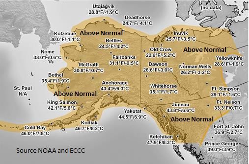
You can also read