2020 Monsoon Outlook - National Weather Service
←
→
Page content transcription
If your browser does not render page correctly, please read the page content below
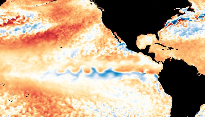
2020 Monsoon Outlook                                                                                 Albuquerque
For Central & Northern New Mexico                                                                       WEATHER FORECAST OFFICE

Figure 1. Sea Surface Temperature Anomalies (SSTAs) from the first week in June 2020 showing tropical instability waves due to
cooling in the eastern equatorial Pacific Ocean. How might this impact the upcoming North American Monsoon (NAM) for
central and northern New Mexico?
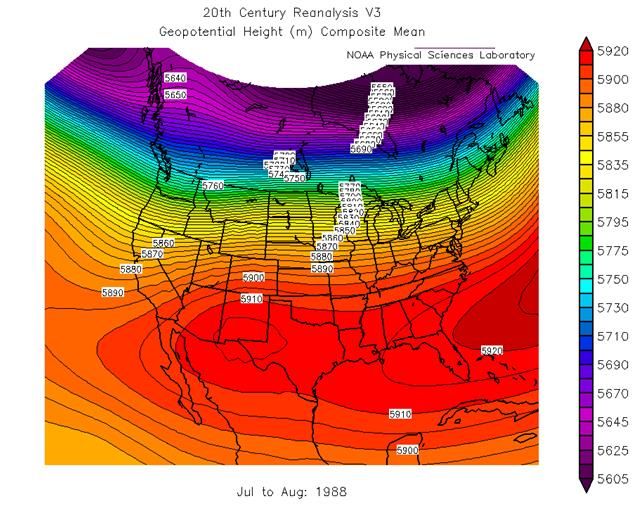
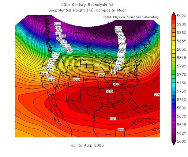
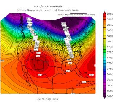
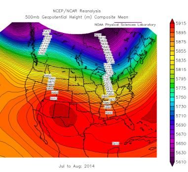
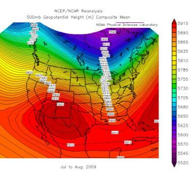
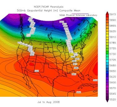
2020 Monsoon Outlook                                                                                                            Albuquerque
 For Central & Northern New Mexico                                                                                               WEATHER FORECAST OFFICE

Figures 2-4. 500-mb heights in July and August from the two wettest monsoon seasons on record, 1988 and 2006, along with 2019.

Let’s start this climate outlook with by first discussing what makes for a good monsoon season in NM. What created very wet years like
1988 and 2006? In both of those years the eastern equatorial Pacific was undergoing relatively rapid change in spring and early summer. In
1988, similar to this year, it was cooling. In 2006, it was warming. Both of those years saw a more active than average convection in the
eastern Pacific which can help draw the Polar Jet Stream farther south along the West Coast. This helps send the ‘Four Corners’ High’
eastward at times, allowing a prolonged deep southerly flow to develop over NM. What’s the catch this year and over the past 15 years or
so? Climate change has resulted in a Polar Jet Stream that is weaker and more volatile. Since the polar regions (mostly land) are warming
faster than the tropics (mostly water), the jet stream is not as concentric as it once was and more upper-level troughs are dropping into the
eastern U.S. (see next slide), forcing the ‘Four Corner’s High’ over NM more often. Also, notice the change in the strength of the upper high
with time (high heights or more dark red = hotter temperatures).
2020 Monsoon Outlook                                                                                                         Albuquerque
                                                                                                                                 WEATHER FORECAST OFFICE

      1999                   2000                   2001                   2002                  2003                  2004                    2005

      2006                   2007                  2008                  2009                  2010                    2011                    2012

      2013                   2014                  2015                   2016                  2017                   2018                   2019
Figures 5-25. 500-mb height charts during July and August from 1999-2019. 500-mb heights range in elevation from 16,000 feet (4,980 meters) to nearly
20,000 feet (6,000 meters) and are considered the "middle" of the atmosphere. What does it show? Where the “Four Corners’ High’ sets up for the heart
of the monsoon season (dark orange/red). When the high center (clockwise circulation) is over the Southern Plains or points southeastward, (e.g.1999,
2001, 2006) sub-tropical moisture is able to stream up from the south. When it’s overhead or over AZ (e.g. 2002, 2003, 2007, 2017, & 2019), moisture is cut
off from the southwest U.S. and is sent out over Baja California and the eastern Pacific Ocean.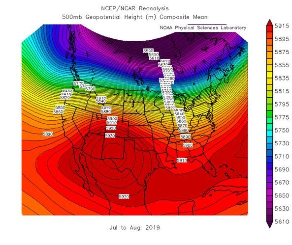
2020 Monsoon Outlook                                                                                     Albuquerque
 Current Sea Surface Temperatures (SSTs)                                                                    WEATHER FORECAST OFFICE

                                                                                          ➢ Multivariate ENSO Index
                                                                                          (MEI) for APR-MAY 2020: -0.2
*SSTs are what
drive tropical &                                                                          ➢ Pacific Decadal Oscillation
sub-tropical                                                                              (PDO) for APR 2020: -0.57
thunderstorms.
It’s these                                                                                ➢ Atlantic Multidecadal
thunderstorms                                                                             Oscillation (AMO) for APR
that drive global                                                                         2020: +0.26
weather & climate.
                                                                                          ➢Pacific Meridional Mode
                                                                                          (PMM) for MAY 2020: -0.53

                                                                                          ➢Oceanic Niño Index (ONI)
                                                                                          (uses Niño 3.4 region - inner
                                                                                          rectangle) for MAM 2020: 0.3

                     Figure 26. SST Anomalies in the Equatorial Pacific Ocean in early
                     June 2020 showing neutral but cooling conditions in the equatorial
                     Pacific.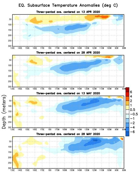
2020 Monsoon Outlook                                                                                  Albuquerque
 Sub-surface Temperatures                                                                                WEATHER FORECAST OFFICE

Figures 27-28. Sub-surface temperature anomalies at the equator. Sub-surface temperatures often lead surface temperatures by
several months. An increasing amount of cool water under the surface provides confidence in climate models that are forecasting
neutral conditions continuing through summer and into early fall.
2020 Monsoon Outlook                                                                                  Albuquerque
 Madden-Julian Oscillation (MJO)                                                                         WEATHER FORECAST OFFICE

Figure 29. The MJO is an area of enhanced thunderstorms that travels around the world every 30 to 60 days from west to east
along/near the equator. Ahead and behind the active stormy area are areas of suppressed convection and drier conditions. The
MJO affects near-surface wind patterns, because the rising air in the stormy area causes surface winds to blow toward the active
area. The MJO can play a role in New Mexico’s weather at any time of year but it tends to have its greatest impacts during
September.
2020 Monsoon Outlook                                                                                       Albuquerque
 Pacific Meridional Mode (PMM)                                                                                WEATHER FORECAST OFFICE

Figure 30. Tropical patterns associated with the positive state of the Pacific (left) and Atlantic (right) Meridional Modes (MM). The
top panels show SST anomalies (shading) and near-surface wind anomalies (arrows), and the bottom panels show precipitation
changes vs. average. Red (green) shading indicates above-average SST (precipitation) and blue (brown) shading indicates below-
average SST (precipitation). MMs are defined by a distinctive sea-surface warming and southwesterly wind anomaly in the vicinity
of the Intertropical Convergence Zone (ITCZ) during boreal spring. In other words, a positive PMM leads to stronger low level
moisture advection northeastward toward the southwest U.S. during the North American Monsoon. Additionally, the majority of
El Niño events over the past four decades are preceded by a positive PMM (Chiang and Vimont 2004, Chang et al., 2007). In
March, 2020 the PMM went negative to -0.53.
2020 Monsoon Outlook                                                                               Albuquerque
 Precipitation Forecasts for July, August & September (JAS)                                           WEATHER FORECAST OFFICE

       Skill

  Precipitation
  rate anomaly
  forecast

Figures 31-36. Climate model precipitation rate anomaly plots from the three climate models which have the highest skill
percentages (top images), the North American Multi-Model Ensemble (NMME), Environment and Climate Change Canada (GEM-
NEMO) and the National Center for Atmospheric Research Community Climate Model (NCAR CCM4) models. All three model
forecasts (bottom row) are forecasting near average precipitation for July, August, and September (JAS) precipitation in New
Mexico. Note the relative lack of skill (i.e., batting averages) from the models with regard to precipitation.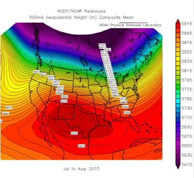
2020 Monsoon Outlook                                                                              Albuquerque
Temperature                                                                                         WEATHER FORECAST OFFICE

Figures 37-42. Climate model temperature anomaly plots from the three climate models which have the highest skill
percentages (top images), the North American Multi-Model Ensemble (NMME), Environment and Climate Change Canada (GEM-
NEMO) and the National Center for Atmospheric Research Community Climate Model (NCAR CCM4) indicate slightly above to
above average temperatures in JAS. Keep in mind the NMME output is from a group/ensemble of model runs while the GEM-
NEMO and NCAR_CCM4 are single runs. Typically, single model runs will show greater precipitation and temperature extremes.
2020 Monsoon Outlook                                                                                Albuquerque
 ENSO Predictions                                                                                      WEATHER FORECAST OFFICE

Figure 43. The vast majority of climate models predict ENSO-neutral conditions through summer and fall 2019. There is a ~65%
chance of ENSO-neutral during Northern Hemisphere summer 2020, with chances decreasing through autumn (to 45-50%).
2020 Monsoon Outlook                                                                               Albuquerque
Climate Prediction Center (CPC)                                                                       WEATHER FORECAST OFFICE

Figures 44-45. CPC agrees with the climate model consensus of near average chances for average precipitation, especially for
southern and eastern NM. Since 2000, only four July through September periods have experienced slightly below average
temperatures with the 14 remaining years above to well above the average statewide mean of 83.7°F.
2020 Monsoon Outlook                                                         Albuquerque
                                                                                WEATHER FORECAST OFFICE
 Summary

➢ Forecasts from the most highly skilled climate forecast models indicate that precipitation in
  central and northern New Mexico during July, August and September (JAS) 2020 will most
  likely range from near to slightly below 1981-2010 climatological averages.

➢ Climate model forecasts along with recent temperature trends indicate that temperatures in
  central and northern New Mexico during JAS 2020 will most likely range from slightly above
  to above average.

➢ What to look for in the coming months: Active thunderstorms in the eastern Pacific Ocean
  (temperature differences thanks to the cooling at the equator will help this year) to help draw
  troughs or closed upper-level lows to just off the West Coast while at the same time, the
  Pacific Northern American Pattern (PNA) goes negative. A negative PNA will help keep
  troughs from dropping into the eastern U.S. and allow the Four Corners’ High to slide
  eastward. An active Atlantic Basin will likely make conditions more complicated.
2020 Monsoon Outlook Albuquerque
Outlook Information WEATHER FORECAST OFFICE
References
• Chiang, J. C. H., D. J. Vimont, 2004: Analogous Pacific and Atlantic Meridional Modes of Tropical
Atmosphere–Ocean Variability. J. Climate, 17, 4143-4158.
• Chang, P., L. Zhang, R. Saravanan, D. J. Vimont, J. C. H. Chiang, L. Ji, H. Seidel, M. K. Tippett, 2007: Pacific
meridional mode and El Niño—Southern Oscillation. Geophysical Research Letters.Vol. 34, Issue 16.
➢ Outlook provided by National Weather Service Forecast
Office Albuquerque, NM.
➢ For further information contact Andrew Church:
andrew.church@noaa.gov (505) 244-9150You can also read