Verification of 2018 HWRF and HMON Performance - HFIP
←
→
Page content transcription
If your browser does not render page correctly, please read the page content below
NCEP Operational Hurricane Modeling Systems

      Verification of 2018 HWRF and HMON Performance
                                The Hurricane Project Team
                                        NOAA/NWS/NCEP/EMC
                                              Presented by
                       #
Bin Liu*, Avichal Mehra , Zhan Zhang*, Lin Zhu*, Weiguo Wang*, Biju Thomas*, Hyun-Sook Kim*, Keqin
Wu*, Sergio Abarca*, Peter Black*, Jili Dong*, Dan Iredell*, Qingfu Liu#, Zaizhong Ma*, Dmitry Sheinin*,
                     Jason Sippel%, Henry Winterbottom*, and Vijay Tallapragada#
           *IMSG at EMC/NCEP/NWS/NOAA; #EMC/NCEP/NWS/NOAA; %HRD/AOML/NOAA
                                          in collaboration with
 HRD/AOML, DTC, NHC, JTWC, GFDL, ESRL, URI, OU, SUNY Albany, CCU, and other HFIP/JHT PIs
                           HFIP Annual Review Meeting, November 5-7, 2018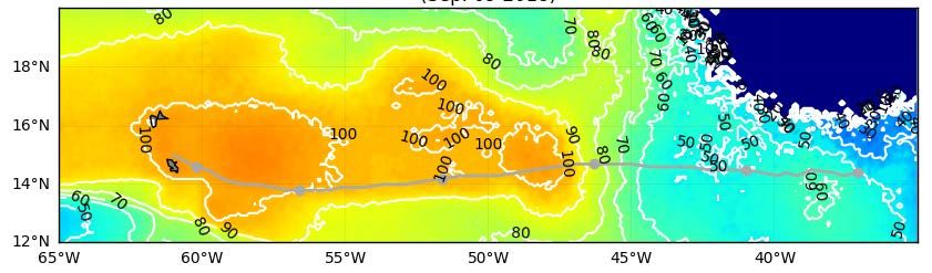
2

                       Outline

•   Overview of FY2018 HWRF and HMON upgrades
•   HWRF/HMON performance for different TC basins
•   Highlights/discussions of model performance for
    individual storms
•   Summary of FY2018 HWRF and HMON performance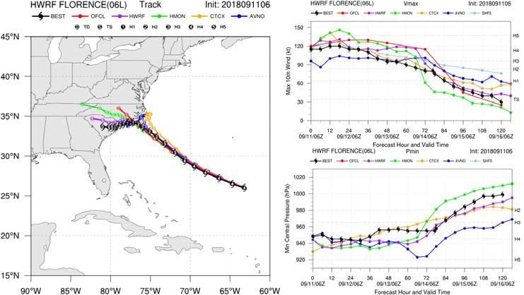
3
                               Highlights of FY2018 HWRF Upgrades
• Infrastructure Enhancements
 – Upgrade dynamic core from WRF3.8.1a to WRF3.9.1 (with bug fixes)                    H218 intensity forecast
 – T&E with 2017 4D-Hybrid GDAS/GFS IC/BC                                        for 2015-2017 NATL/EPAC storms
 – Increase horizontal resolution from (18/6/2-km) to (13.5/4.5/1.5-km)
 – Slightly reduced domain sizes for the two nested domains
                                                                                                            NATL
 – Unify the vertical level configuration for all global TC basins (L75 with a
   model top of 10 hPa)
 – Increase parent domain size (with HRD)

• Vortex Initialization/DA Improvements (with HRD)
 –   GSI code upgrades and disable SSMI channel 2 data
 –   Stochastic physics for self-cycled DA ensemble members                               Intensity skill
                                                                                                                   H217
 –   Admit new data sets (GOES-16 AMVs, NOAA-20, SFMR, TDR/G-IV)
 –   Consider dropsonde drifting                                                                                   H218
• Physics Advancements                                                                                             OFCL
 –   Adjust the horizontal diffusion and convergence damping coefficients
                                                                                                            EPAC
 –   Updated RRTMG scheme with a new cloud overlap method (DTC/AER)
 –   In-cloud mixing modification for GFS EDMF PBL scheme (Zhu, FIU)
 –   YSU PBL scheme (Fovell, University at Albany - SUNY)

• Air-Sea Interaction and Coupling
 – Unified HWRF/HMON coupler with double precision coordinates from
   the HWRF component                                                                     Intensity skill
 – Add a POM ocean domain for the CPAC basin
 – Enable ocean coupling (with HYCOM) for Southern Hemisphere basins
 – Sea surface wave initial condition from global wave model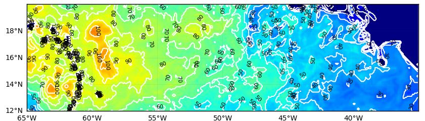
4
                          Highlights of FY2018 HMON Upgrades
                                                                         M218 intensity forecast
• System and Resolution Enhancements                               for 2015-2017 NATL/EPAC storms
 – Upgrade to the latest NMMB dynamic core (with bug fixes)
 – T&E with 2017 4D-Hybrid GDAS/GFS IC/BC                                                     NATL
 – Increase vertical levels from 42 to 51 with a model top of 50
   hPa
 – NMMB dynamic core optimization (IBM analyst)
 – Change diffusion parameterization

• Initialization Improvements                                               Intensity skill          M217
 – Updated composite vortex                                                                          M218
• Physics Advancements                                                                               OFCL
 – Update momentum and enthalpy exchange coefficients
 – Use scale-aware SAS scheme                                                                 EPAC
 – Use GFS-EDMF PBL scheme
 – Explore using of MYJ surface layer + MYJ PBL

• Coupling Upgrades
 – Use unified HWRF/HMON coupler
 – Add HYCOM coupling in NATL basin                                         Intensity skill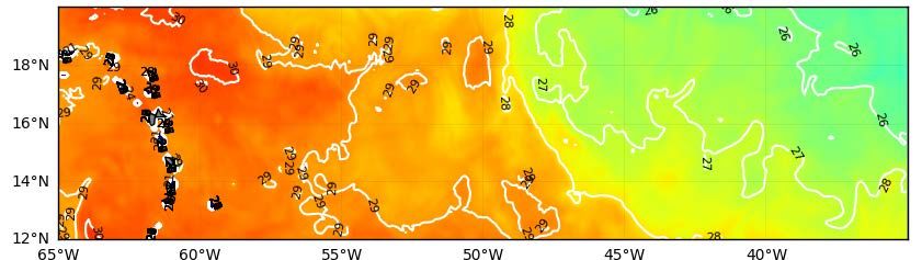
5

        Verification for 2018 North Atlantic Basin
               Real-Time Performance (Early Guidance)

       Track error                 Intensity error                     Intensity bias

OFCL
HWRF
HMON
CTCX
GFS

            Track skill                              Intensity skill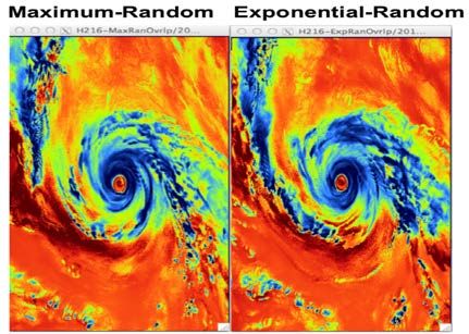
6

       Verification for 2018 Eastern Pacific Basin
               Real-Time Performance (Early Guidance)

       Track error                 Intensity error                Intensity bias

OFCL
HWRF
HMON
CTCX
GFS

             Track skill                        Intensity skill
7

       Verification for 2018 Western Pacific Basin
               Real-Time Performance (Early Guidance)

       Track error                 Intensity error                 Intensity bias

JTWC
HWRF
COTC
CTCX
GFS

              Track skill                        Intensity skill
8

Intensity Distribution and Wind-Pressure Relation
            2018 HWRF/HMON Performance

NATL                   EPAC                    WPAC

             NATL                                   EPAC

                     BEST
                     HWRF
                     HMON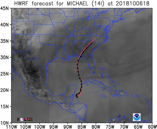
9
              24hr Intensity Change Distribution
             and Model Performance for RI Storms

                 NATL                               EPAC                            WPAC

                              BEST
                              HWRF
                   RI         HMON                    RI                               RI

Intensity errors for 2018 NATL/EPAC/WPAC storms experienced rapid intensification

      Intensity error                   Intensity error                    Intensity error

                           HWRF HMON COTC CTCX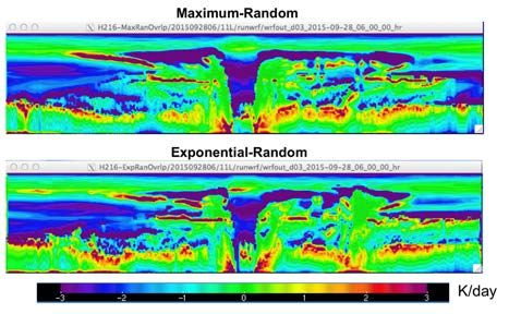
10
                      Rapid Intensity Change Forecast Performance
                                 HWRF POD and FAR for RI

        POD = 17.3%                POD = 9.6%              POD= 10.1%
        FAR = 71.6%                FAR = 76.8%             FAR= 88.8%

 2017
HWRF

                      NATL                       EPAC                    WPAC

        POD = 16.1%                POD = 16.3%             POD = 28.3%
        FAR = 76.3%                FAR = 69.3%             FAR = 51.2%
 2018
HWRF
11
Rapid Intensity Change Forecast Performance
HMON POD and FAR for RI
POD = 9.2%
POD = 20.0%
FAR = 79.2%
FAR = 68.6%
2017
HMON
NATL EPAC
POD = 6.0% POD = 12.6%
FAR = 83.8% FAR = 70.7%
2018
HMON12
HWRF/HMON Forecast for Florence (06L)
Track, intensity and rainfall forecast
HWRF
HWRF 2018091106Z
HMON
CTCX
GFS 78-hr
before
landfall
Track error
Intensity error From NWS
Eastern
Region13
HWRF/HMON Forecast for Michael (14L)
Track and intensity errors and composites
HWRF forecast at 96-hr before landfall
HWRF
HMON
CTCX
Track error
GFS
Intensity error14
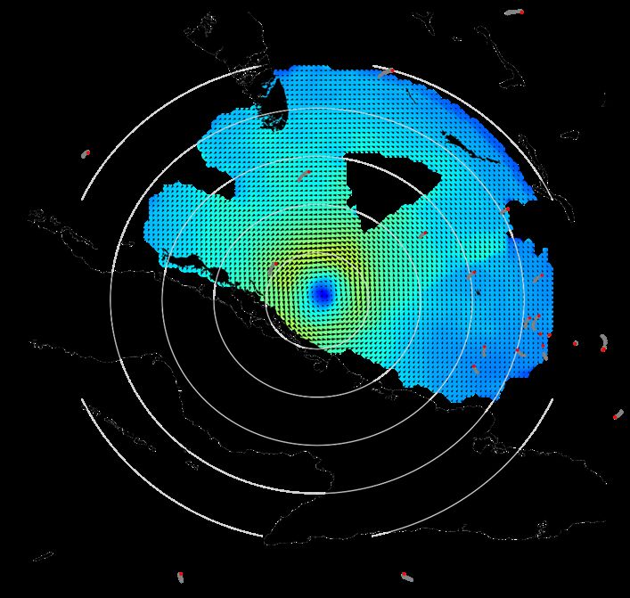
HWRF Forecast for Michael (14L)
HWRF ocean initialization and coupling
OHC of 20181010 SST of 20181006 HWRF SST 2018100618Z F000
HWRF SST Cooling 2018100618Z F090
Satellite-derived OHC and SST
from UM RSMAS15
HWRF/HMON Forecast for Isaac (09L)
Track and intensity errors and composites
HWRF HWRF HWRF
HMON
CTCX
Track error GFS
Intensity error forHMON
NATL without Isaac
HMON
Intensity error
CTCX16
HWRF Ocean Initialization for Isaac (09L)
SST and D26 valid at 2019090900Z
GFS GDEM
NSST
RTOFS RTOFS
NCODA NCODA
Satellite
MW-IR Derived
OI SST
SST D2617
HWRF/HMON Forecast for Some EPAC Storms
Hector (10E), Lane (14E) and Willa (24E)
HWRF
HMON
CTCX
Hector 10E Lane 14E Willa 24E
GFS
Track error Track error Track error
Intensity error Intensity error Intensity error18
HWRF Forecast for Some WPAC Storms
Mangkhut (26W), Trami (28W), and Kong-Rey (30W)
26W 28W 30W
HWRF
COTC
CTCX
Intensity error Intensity error Intensity error
Adjust codamp coefficient and upper level dwdt damping levels
28W 28W
30W 30W
Track error
Intensity error19
Summary for HWRF Performance
• FY2018 HWRF continues to be one of the best dynamical intensity
guidance models. HWRF’s intensity forecast skill is very close to
OFCL guidance within day 3 for NATL storms; though is overall
behind OFCL and CTCX for EPAC storms. For WPAC, HWRF’s
intensity is better than other dynamical intensity guidance models,
while being slightly behind JTWC’s official forecast.
• For intensity forecast of RI storms, HWRF performed very well for all
three basins (NATL/EPAC/WPAC), especially with much improved
POD/FAR for RI forecasting of WPAC storms.
• For track forecast skill, HWRF is overall very close or slightly behind
its parent model GFS.
• There were some over-intensification cycles for Isaac (09L) and other
storms. Also several cycles of Mangkhut (26W, a very strong WPAC
storm) experienced numerical instability issue.20
Summary for HMON Performance
• FY2018 HMON implementation was the first upgrade after it replaced the
legacy GFDL hurricane model last year.
• HMON performed very well for track forecast of EPAC storms, even better
than its parent model (GFS). Whereas, for NATL storms, its track forecast
was somewhat behind other models.
• For intensity forecast, HMON was overall a little behind HWRF, and
struggled for both NATL and EPAC basins, with overall weaker intensity
biases especially for longer forecast lead times.
• For individual storms/forecast cycles, HMON and HWRF provided mixed
track and intensity forecast skills. For example, HMON performed very well
for Isaac (09L), while HWRF struggled for lots of cycles for this storm.21
Thank you!
Real-time NCEP operational model guidance for all global TCs
HWRF: http://www.emc.ncep.noaa.gov/HWRF
HMON: http://www.emc.ncep.noaa.gov/gc_wmb/vxt/HMON22
FY2018 HWRF/HMON Configurations
HWRF HMON
Dynamic core Non-hydrostatic, NMM-E Non-hydrostatic, NMM-B
Resolution and 13.5/4.5/1.5 km; 77°/18°/6°; L75(10mb top); 18/6/2 km; 75°/12°/8°; L51(50mb top);
nesting two-way nesting and vortex-following two-way nesting and vortex-following
Data Assimilation Vortex relocation & adjustment; self-cycled Modified vortex relocation & adjustment;
and Initialization hybrid EnKF-GSI with inner core DA (TDR) no DA
Physics Updated surface (GFDL); NOAH LSM; Surface (GFDL); NOAH LSM; GFS-
GFS-EDMF PBL; scale-aware SAS; Ferrier- EDMF PBL; scale-aware SAS; Ferrier-
Aligo; Modified RRTMG Aligo; RRTMG
Coupling Unified NCEP coupler; Unified NCEP coupler;
MPIPOM/HYCOM; RTOFS/GDEM; HYCOM; RTOFS/NCODA;
one-way coupling to WW3 no wave coupling
Post-processing NHC interpolation method; NHC interpolation method;
updated GFDL tracker GFDL tracker
NEMS/NUOPC No Yes with moving nests
Computation cost 81 nodes in 98 mins 26 nodes in 95 mins
for forecast job23
Toward High Resolution Convection Resolving
Modeling in Operational HWRF
FY2017 HWRF: 18/6/2 km FY2018 HWRF: 13.5/4.5/1.5 km
Track error Intensity error Intensity skill
Overall neutral impact for track while substantial improvements for intensity24
Considering Dropsonde Drifting in DA
Track skill
Improvement for track
Intensity skill
Observed radar winds (shaded) and wind vectors (arrows),
and the dropsonde release locations (red), as well as its Neutral for intensity
subsequent computed dropsonde advection trajectories
(grey) for Hurricane Irma (11L2017) on 08 September.25
Modified Cloud Overlap Method for RRTMG
Radiative Heating Rates - LW
“Maximum-random” (FY2017 HWRF) FY2017 HWRF
• Continuous cloud layers overlap as much as possible; blocks of
cloud layers with clearance between are oriented randomly
“Exponential-random” (FY2018 HWRF)
FY2018 HWRF
• Continuous cloud layers use overlap that transitions exponentially
from maximum to random with distance through clouds, blocks of
cloud layers with clearance between are oriented randomly
• Constant decorrelation length (Z0 = ~1-2 km) controls rate of
exponential transition Vertical west-east slice: through Joaquin eye
Radiative Heating Rates - SW
Track skill Intensity skill
K/day
Overall positive impacts for both track and intensity FY2017 HWRF FY2018 HWRF
Inner nest at ~900 hPa, Joaquin26
FY2018 HWRF Configurations for Different TC Basins
Basin Ocean Coupling Wave Coupling DA Ensemble DA Vertical Top
TDR/priority
NATL POM GDEM/GFSSST WW3 1-way Always 75 level 10 mb
storm
TDR/priority
EPAC POM RTOFS WW3 1-way Always 75 level 10 mb
storm
CPAC POM RTOFS WW3 1-way None None 75 level 10 mb
WPAC HYCOM None None None 75 level 10 mb
NIO HYCOM None None None 75 level 10 mb
SIO HYCOM None None None 75 level 10 mb
SPAC HYCOM None None None 75 level 10 mb
• EnKF self-cycled DA system for one TDR or priority storm
• 75 vertical levels with 10-hPa top for all global TC basins
• Ocean coupling for all global TC basins (POM for NHC basins, HYCOM for JTWC basins)
• POM RTOFS initialization for EPAC/CPAC basin
• One-way coupling to wave model for NATL, EPAC, and CPAC
• Sea surface wave IC/BC come from global wave modelYou can also read