A POLICY MODEL OF ADAPTATION MITIGATION AND SOCIAL RISKS THE VOLCANO ERUPTION DISASTER OF SINABUNG IN KARO REGENCY - INDONESIA
←
→
Page content transcription
If your browser does not render page correctly, please read the page content below
International Journal of GEOMATE, Aug. 2019, Vol.17, Issue 60, pp.190-196
  Geotec., Const. Mat. & Env., DOI: https://doi.org/10.21660/2019.60.50944
  ISSN: 2186-2982 (Print), 2186-2990 (Online), Japan

 A POLICY MODEL OF ADAPTATION MITIGATION AND SOCIAL
 RISKS THE VOLCANO ERUPTION DISASTER OF SINABUNG IN
              KARO REGENCY - INDONESIA

         *Dedi Hermon1 2, Ganefri2, Erianjoni2 3, Indang Dewata2 4, Paus Iskarni1, Alexander Syam2 5

                        *1Department of Geography – Padang State University, Indonesia
                                2
                                 Postgraduate - Padang State University, Indonesia
                         3
                           Department of Sociology – Padang State University, Indonesia
                         4
                           Department of Chemistry – Padang State University, Indonesia
                                        5
                                          STKIP Pesisir Selatan, Indonesia

      *Corresponding Author, Received: 09 Jan. 2019, Revised: 04 Feb. 2019, Accepted: 20 Feb. 2019

ABSTRACT: The purpose of this research was to determine the level of volcano eruption risk and compile a
disaster risk mitigation model for the Sinabung volcano eruption. Analysis technique of volcano eruption
disaster risk of Sinabung uses scoring techniques for all indicators. The volcano eruption disaster risk of
Sinabung refers to eruption hazard level, vulnerability level, and disaster prevention capacity index. The level
of volcano eruption hazard and vulnerability of Sinabung volcano was analyzed by GIS approach using
ArcGIS 10.1 software, based on units of sub-district administration. The capacity index was analyzed based
on the Hyogo Framework for Action-HFA 2005-2015. While the disaster mitigation and policy model of
adaptation of volcano eruption Sinabung were analyzed with FGD and AHP. The level of volcano eruption
disaster risk of Sinabung is high > 49 (614). As for the mitigation model of the eruption risk of Sinabung
volcano and model of adaptation policy based on alternative priorities for disaster risk reduction has 4 main
priorities, i.e: 1) Relocation for identify, assess and monitor of disaster risk and implement an early warning
system; 2) Utilize of knowledge, innovation and education to build a culture of safety and resilience at all
levels; 3) Make of disaster risk reduction a priority of national and region implemented through strong
institutions; and 4) the reducing of underlying factors that increase disaster risk.

Keywords: Sinabung Volcano, Disaster Risk, Mitigation Model, Karo Regency

1. INTRODUCTION                                                    become the highest peak in the province of North
                                                                   Sumatra, with the height of the mountain is around
    The Indonesian archipelago state is also                       2.460 meters. [4] explained the feasibility of the
traversed by two active lanes in the world, the                    evacuation route for the risk adaptation of the
Pacific and Mediterranean circums. The Pacific                     Sinabung volcano in Kato Regency is done by
Circum includes islands in Sulawesi island the                     Network Analysis which is found in the Arc GIS
northern part and Maluku the northern part. The                    10.1 program. Where Network Analysis a system
Mediterranean circums is divided into two parts,                   of linear features that are interrelated in each
the arc in the active (inner arc) and the outer arc                constituent element where a flow of movement in a
that is no longer active. Inner arc Mediterranean                  network system besides that it is also analyzed 1)
circuits include volcanoes found on the mainland                   number of settlements; 2) population; 3) length of
of Sumatra, Java, Bali, Lombok, Nusa Tenggara,                     the line; and 4) accessibility and feasibility of
part of Sulawesi island and ending in the Banda                    evacuation routes.
Sea. The outer arc of the Mediterranean (outer arc)                    Sinabung volcano has not been recorded
encompasses the islands in Sumatra island the                      erupting since 1.600 years [5], but suddenly active
western part such as Mentawai archipelago, Nias                    again and erupted at the date of August 27, 2010,
archipelago, Enggano island continues to the                       this mountain released smoke and volcanic ash. On
southern coast of Java island, and Nusatenggara                    August 29, 2010 at around At 00:15 pm, this
islands cover the Sumba island [1].                                mountain release volcanic fumes and ash. The
    One of the active volcano that recently showed                 status of the mountain is raised to "Beware".
its activity is the Sinabung volcano. Sinabung                         Twelve thousand residents around nearby are
volcano in Karo language "Delen Gunung                             evacuated and accommodated in 8 locations. The
Sinabung" is a volcano in the Karo highlands,                      sound of this eruption was heard up to a distance
Karo Regency, North Sumatra - Indonesia. [2] [3]                   of 8 kilometres. This volcanic dust is sprayed up to
adds Sinabung volcano close to Sibayak mount are                   5,000 meters in the air [6]. Based on TRIBUNE
two active volcanoes in North Sumatra and                          NEWS media reports (2015) the ash of Sinabung

                                                             190
International Journal of GEOMATE, Aug. 2019, Vol.17, Issue 60, pp.190-196
volcano tends to slide from the southwest headed Sinabung in Karo Regency is carried out
the northeast. The partially of Medan city is also descriptively based on the results of research that
covered with ash from Sinabung volcano. has been carried out as a criterion for the
Kualanamu and Polonia Airport in Medan City formulation of a mitigation policy model, i.e: 1)
reportedly did experience air travel disruption. One the volcano eruption hazard level of Sinabung; 2)
person reportedly died of a respiratory disorder the volcano eruption the vulnerability level of
while evacuating from his home. The results of the Sinabung; and 3) the volcano eruption risk level of
eruption of Sinabung volcano emit a thick black Sinabung. The formulation of the volcano eruption
smog accompanied by the rain of sand and mitigation policy model of Sinabung is classified
volcanic ash that covers thousands of hectares of into several stages, i.e: 1) the compile of
farmers' crops that are below a radius of 6 mitigation policy alternative the volcanic eruption
kilometres. of Sinabung based on further development of
Volcanic dust causes many of the farmers' primary and secondary data research, in the form
crops on the mountain slopes to die and damage. of a description of things that must be developed
An estimated 15.341 Ha of agricultural crops are into public policy priorities [8-10]; 2) the
threatened with crop failure. Gray volcanic dust formulate of priorities for the volcano eruption
has covered the forest, villages, and surrounding mitigation policy of Sinabung [11-13]; and 3) the
agricultural land [7], so that the author's mind selection of priorities the volcanic eruption
appeared to research there is a whether danger of mitigation policy of Sinabung through alternative
volcanic dust to the health of local society, selection to be made a priority by Bayes method
agricultural crops, and livestock of local society. and Focus Group Discussion (FGD) [14-17].
2. RESEARCH METHODS 3. RESULTS AND DISCUSSION
2.1 Volcano eruption the risk level of Sinabung 3.1 Volcano eruption the risk level of Sinabung
To see the volcano eruption risk level of Based on the eruption nature and circumstances
Sinabung seen from 3 elements, i.e: 1) the volcanic of the Sinabung volcano, then the potential
eruption hazard level; 2) the volcanic eruption eruption hazards that may occur are 1) pyroclastic
vulnerability level; and 3) the capacity of handling flow (hot clouds); 2) pyroclastic falls (the bursts of
capacity the volcano eruption of Sinabung in Karo incandescent rock and ash rain); and 3) lava flows
Regency. The volcano eruption risk level of [18-23]. [24] adds based on the hazard level of
Sinabung is analyzed in each sub-district Sinabung volcano eruption that might happen, the
administrative unit with a scoring method against region of the disaster-prone of Sinabung volcano
the volcanic eruption hazard indicator according to can be divided into three of the vulnerability level
the Regulation of the BNPB No. 02 of 2012 based from low to high, however based on the analysis of
on the danger indicator of a volcanic eruption. the eruption hazard indicator according to Head
Regulation, Agency of National Disaster
2.2 Policy model of adaptation-mitigation and Management (BNPB) No. 02 of 2012 the volcano
social risk of the volcano eruption of Sinabung eruption risk level of Sinabung belongs on the
medium and high hazard levels (Tabel 1).
The formulation of a policy model for
mitigating the risk the volcano eruption of
Table 1 The volcano eruption risk levels of Sinabung
Hazard Vulnerability Capacity index Risk
No Sub-district corrected corrected corrected corrected
criteria criteria criteria criteria
standard standard standard standard
1 Simpang Empat 22.5 medium 18.8 medium 2.75 high 44.05 medium
2 Payung 20 medium 15.3 low 2.5 high 37,8 medium
3 Tiganderket 28 high 19.05 medium 2 medium 49.05 high
4 Kabanjahe 20 medium 27.6 high 2.5 High 50.1 high
5 Kutabuluh 21 medium 17.3 medium 1.75 medium 40.05 medium
6 Leubaleng 19 medium 20.05 medium 1.75 medium 40.08 medium
7 Mardingding 28 high 19.05 medium 2.5 high 49,55 high
8 Tigabinanga 21.5 medium 21.8 medium 1.75 medium 45.05 medium
9 Tiga Panah 21.5 medium 20.8 medium 2.25 medium 44.55 medium
10 Barusjahe 27.5 high 20.8 high 2 medium 50.3 high
191International Journal of GEOMATE, Aug. 2019, Vol.17, Issue 60, pp.190-196
Hazard Vulnerability Capacity index Risk
No Sub-district corrected corrected corrected corrected
criteria criteria criteria criteria
standard standard standard standard
11 Namanteran 29 high 10.8 low 2.5 high 42.3 medium
12 Berastagi 27 high 27.6 high 2.25 medium 56.85 high
13 Dolatrayat 29 high 17.3 medium 1.75 medium 48.05 medium
14 Merdeka 27 high 15.3 low 1.5 low 43.8 medium
15 Merek 22.5 medium 20.25 medium 1.75 medium 44.5 medium
16 Munte 21.5 medium 21.4 medium 2 medium 44.9 medium
17 Juhar 19 medium 20.05 medium 1.75 medium 40.8 medium
Source: Results of data analysis, 2018.
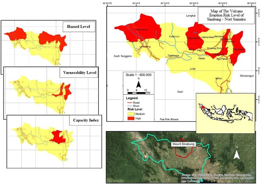
The volcano eruption hazard levels of the land use, where the result is the highest level of
highest Sinabung i.e in the sub-district of vulnerability located in the sub-district of
Namanteran, Dolatrayat, Barusjahe, Berastagi, Berastagi and Kabanjahe. While to the disaster
Merdeka, and Tiganderket. As for the volcano management capability index of the highest
eruption vulnerability levels of Sinabung based on volcano eruption of Sinabung is in the sub-district
Head Regulation BNPB No. 02 of 2012 with of Simpang Empat, Payung, Kabanjahe,
indicator of the vulnerability i.e: 1) population Mardingding, and Namanteran. Based on the map
density; 2) female sex ratio (%); 3) ratio of age analysis of the volcano eruption risk levels of
groups 0-14 years and > 64 years (%); 4) ratio of Sinabung. Showing that in the sub-district of
disabled people (%); 5) ratio of poor households Mardingding, Tiganderket, Dolatrayat, Kabanjahe,
(%); 6) the land area of productive (rice and Barusjahe are in the high category or the
fields/agriculture, moor/shrubs, mixed garden) hazard (Beware). The map of disaster risk levels is
(Ha); 6) number of livestock (tail); 7) number of obtained based on the results of the map analysis
houses (units); 8) number of public facilities of hazard, map of vulnerability, and map of index
(education, health, and offices) (units); and 9) the capacity that can be seen on the map Fig.1 below.
Fig.1 Map of The volcano eruption a risk level of Sinabung.
Based on data records from the Agency of 2.3% every year. [25] state that high population
Center Statistics (BPS) of 2017. Demographically, growth in a region will create conflict between
Karo Regency has a population growth rate of land uses. [1] adds based on Law No. 24 of 2007
192International Journal of GEOMATE, Aug. 2019, Vol.17, Issue 60, pp.190-196
concerning disaster management states that Disaster mitigation is an effort made to prevent
mitigation is a series of efforts to reduce disaster disasters or reduce the impact of disasters which
risk. Based on the results of the analysis shows include preparedness and vigilance as the volcano
that there are three main alternatives to the eruption disaster mitigation model of Sinabung is
direction of disaster mitigation policy, i.e: disaster based on the results of FGD with the society,
education, increased socialization in disaster-prone Agency of National Disaster Management
zones, and disaster-based spatial planning. (BNPB), Agency of Sub-National Level Disaster
Management (BPBD), Agency of Development
3.2 Policy model of adaptation-mitigation and Planning of Sub-National Level (BAPPEDA), and
social risk of the volcano eruption of Sinabung NGOs regarding disaster mitigation for sub-
districts included in the hazard (Fig 2).
Fig. 2 Policy Model of adaptation mitigation and social risk of the volcano eruption of Sinabung.
193International Journal of GEOMATE, Aug. 2019, Vol.17, Issue 60, pp.190-196
Based on the analysis of the volcano eruption About 15.341 Ha of the Karo Regency region is a
disaster risk mitigation and policy model of high hazard level zone against the disaster of
adaptation of Sinabung volcano in Karo Regency, volcanic eruptions with settlement regions that are
it can be seen from spatial planning, mitigation, built in high hazard zones are around 27%. Efforts
and adaptation that alternative priorities for to reduce risk by using disaster risk mitigation and
disaster risk reduction are 4 main priorities, i.e: 1) adaptation policy of the volcano eruption in
Relocation identifying, assessing, monitoring Sinabung, i.e: relocation, disaster education,
disaster risk, and implementing an early warning increasing socialization in disaster-prone zones,
system; 2) Utilizing knowledge, innovation, and and disaster-based spatial planning. It was
suggested to the Karo Regency government to
education to build a culture of safety and resilience
include disaster education curricula starting from
at all levels; 3) Making "Disaster Risk
the elementary to secondary schools, conducting
Reduction/DRR" a national and regional priority
socialization in disaster-prone zones, and
implemented through strong institutions; and 4) conducting disaster-based spatial planning.
Reducing factors fundamental causes of the
emergence or increase of disaster risk. 5. ACKNOWLEDGEMENTS
[26] stated one effort to reduce the impact of
disaster risk by increasing the capacity of the This research can be carried out smoothly,
society in dealing with disasters. [27-30] explained because of the help and cooperation of various
disaster education and increased socialization in parties. Therefore, the author would like to thank
disaster-prone zones as an indicator to increase the Rector of Padang State University and the
society capacity in reducing disaster risk. Government of Karo Regency - North Sumatra
Enhancement the society capacity to reduce the Province who have provided the opportunity and
volcano eruption risk disaster of Sinabung in Karo time to sharpen the academic ability us, especially
Regency can be implemented by including disaster in the field of volcanic disasters.
education in the school curriculum. With including
disaster education curriculum to the society in 6. REFERENCES
disaster-prone regions is an effective effort to
reduce the risk of disasters. [31-34] states that [1] Hermon D. Geografi Bencana Alam. Jakarta:
including disaster education in all elements of PT RajaGrafindo Persada, 2015.
[2] Hermon D. Desain Kebijakan Tanggap
society can reduce 40-60% of losses due to
Darurat dan Pemulihan Bencana Letusan
disasters. In addition, [35-40] adds that one
Gunung Sinabung. Prosiding Seminar
solution mitigates the vulnerability region of the
Nasional Geografi: Master Program of
volcanic eruption disaster by entering the element Geography Education, Universitas Negeri
of disaster in the preparation of spatial planning. Padang. 2014.
This is in accordance with the direction of disaster [3] González P J., Singh K D and Tiampo K F.
mitigation policies by including disaster-based Shallow hydrothermal pressurization before
spatial planning. the 2010 eruption of Mount Sinabung
Volcano, Indonesia, observed by use of
4. CONCLUSION ALOS satellite radar interferometry. Pure and
Applied Geophysics, 172(11), 2015, pp.
The volcano eruption disaster risk levels of 3229-3245.
Sinabung in Karo District is high because > 49 [4] Putra A and Mutmainah H. The Mapping of
(614), this result is also in line with the IRB BNPB Temporary Evacuation Site (TES) and
which suggests that the volcano eruption disaster Tsunami Evacuation Route in North Pagai
risk level of Sinabung in Karo Regency is high. Island, Mentawai Islands Regency-Indonesia.
The volcano of Sinabung in Karo Regency IOP Conference Series: Earth and
experienced an increase in the volcanic eruption Environmental Science, 47(1), 2016, pp.
disaster from the frequency of occurrence and the 012020.
region affected by volcanic ash. Where the [5] Haerani N., Basuki A., Suparman Y.,
volcanic dust that hit the region resulted in many Primulyana S., Prambada O., Loeqman A and
farmers' plants that were on the slopes of the Ohkura T. Evaluation of volcanic activity at
mountain that were dead and damaged. The Sinabung volcano, after more than 400 years
grayish white volcanic dust covered the forest, of quiet. Journal of Disaster Research, 7(1),
village and surrounding agricultural land. The high 2012, pp. 37.
intensity of volcanic ash distribution and [6] Gunawan H., Budianto A., Prambada O.,
conversion of forest regions to other uses is a McCausland W., Pallister J and Iguchi M.
factor that causes carbon uptake to be unstable. Overview of the eruptions of Sinabung
194International Journal of GEOMATE, Aug. 2019, Vol.17, Issue 60, pp.190-196
eruption, 2010 and 2013–present and details pyroclastic flows at Soufriere Hills Volcano,
of the 2013 phreatomagmatic. Journal of Montserrat. Geological Society, London,
Volcanology and Geothermal Research, 2017. Memoirs, 21(1), 2002, pp 173-190.
[7] Alfian Z., Zaidar Nst E and Taufiq M. [21] Blong R J. Volcanic hazards: a sourcebook
Qualitative and Quantitative Analysis of on the effects of eruptions. 2013, Elsevier.
Heavy Metal and Mineral of Volcanic [22] Sutawidjaja I S., Prambada O and Siregar D.
Ashmount Sinabung by Using Inductively A. The August 2010 Phreatic Eruption of
Coupled Plasma (Icp-Oes). Der Pharma Mount Sinabung, North Sumatra. Indonesian
Chemica, 9(5), 2017, pp.18-22. Journal on Geoscience, 8(1), 2013, pp. 55-61.
[8] Aspinall W and Blong R. Volcanic risk [23] Magsi H., Torre A., Liu Y and Sheikh M J.
assessment. The Encyclopedia of Volcanoes Land use conflicts in the developing
(Second Edition), 2015, pp. 1215-1231. countries: proximate driving forces and
[9] Gultom D I. Trustworthy and participatory preventive measures. The Pakistan
community-based disaster communication: a Development Review, 56(1), 2017, pp.19-30.
case study of Jalin Merapi in the 2010 Merapi [24] Nakada S., Zaennudin A., Yoshimoto M.,
eruption in Indonesia, 2016. Maeno F., Suzuki Y., Hokanishi N and
[10] Pean T Y. A framework to improve the Triastuty H. Growth process of the lava
product development process to achieve more dome/flow complex at Sinabung Volcano
effective sanitation response during during 2013–2016. Journal of Volcanology
emergencies, 2016. and Geothermal Research, 2017.
[11] Eriyatno S F. Riset Kebijakan; Metode [25] Adila I., Dewi W W A., Tamitiadini D and
Penelitian Untuk Pascasarjana. Bogor (ID): Syauki W R. Disaster mitigation action plan:
IPB Pr, 2007. Digital media on improving accountability
[12] Sadyohutomo M. Manajemen kota dan and community relationships. In IOP
wilayah: realita & tantangan. Jakarta: Bumi Conference Series: Earth and Environmental
Aksara, 2008. Science, 70(1), 2017. pp. 012016,
[13] Andreastuti S., Paripurno E., Gunawan H., [26] Dekens J. Local knowledge for disaster
Budianto A., Syahbana D and Pallister J. preparedness: A literature review.
Character of community response to volcanic International Centre for Integrated Mountain
crises at Sinabung and Kelud volcanoes. Development (ICIMOD), 2007.
Journal of Volcanology and Geothermal [27] Suroso D S A., Sagala S A., Alberdi H A and
Research, 2017. Wulandari Y. Does Social Protection on
[14] Hermon D. Dinamika Permukiman dan Education Increase the Capacity of
Arahan Kebijakan Pengembangan Communities in Facing Disasters?. In IOP
Permukiman pada Kawasan Rawan Longsor Conference Series: Earth and Environmental
di Kota Padang. Disertasi, 2009, IPB Bogor. Science, 158(1), 2018, pp. 012036.
[15] Hermon D. Impacts of land cover change on [28] Witvorapong N., Muttarak R and Pothisiri W.
climate trend in Padang Indonesia. Social participation and disaster risk
Indonesian Journal of Geography, 46(2), reduction behaviors in tsunami prone areas.
2014, pp. 138-142. PLoS one, 10(7), 2015. e0130862.
[16] Hermon D. Climate Change Mitigation. [29] Kusumastuti R D., Husodo Z A., Suardi L
Rajawali Pers (Radjagrafindo). Jakarta, 2017. and Danarsari D N. Developing a resilience
[17] Lestari P., Paripurno E T and Nugroho A R. index towards natural disasters in Indonesia.
B. Disaster Risk Reduction Based on International journal of disaster risk reduction,
Community through a Contingency Plan for 10, 2014, pp. 327-340.
Mount Sinabung. Jurnal Ilmu Sosial dan Ilmu [30] Miceli R., Sotgiu I and Settanni M. Disaster
Politik, 21(3), 2018, pp. 231-245. preparedness and perception of flood risk: A
[18] Moore J G and Melson W G. Nuees ardentes study in an alpine valley in Italy. Journal of
of the 1968 eruption of Mayon volcano, environmental psychology, 28(2), 2008. pp
Philippines. Bulletin Volcanologique, 33(2), 164-173.
1969, pp. 600-620. [31] Pourhosseini S S., Ardalan A and
[19] Ratdomopurbo A and Poupinet G. An Mehrolhassani M H. Key aspects of
overview of the seismicity of Merapi volcano providing healthcare services in disaster
(Java, Indonesia), 1983–1994. Journal of response stage. Iranian journal of public
Volcanology and Geothermal Research, health, 44(1), 2015, pp. 111.
100(1-4), 2000, pp. 193-214. [32] Witvorapong N., Muttarak R and Pothisiri W.
[20] Calder E S., Luckett R., Sparks R S J and Social participation and disaster risk
Voight B. Mechanisms of lava dome reduction behaviors in tsunami prone areas.
instability and generation of rockfalls and PLoS one, 10(7), 2015, e0130862.
195International Journal of GEOMATE, Aug. 2019, Vol.17, Issue 60, pp.190-196
[33] Achora S and Kamanyire J K. Disaster crises at Sinabung and Kelud volcanoes.
Preparedness: Need for inclusion in Journal of Volcanology and Geothermal
undergraduate nursing education. Sultan Research. 2017.
Qaboos University Medical Journal, 16(1), [38] Maharani Y N., Lee S and Ki S J. Social
2016. e15. vulnerability at a local level around the
[34] Perry R W and Lindell M K. Preparedness for Merapi volcano. International Journal of
emergency response: guidelines for the Disaster Risk Reduction, 20, 2016, pp. 63-77.
emergency planning process. Disasters, 27(4), [39] Hermon D. Evaluation of Physical
2003. pp. 336-350. Development of The Coastal Tourism
[35] Van Westen C J. Remote sensing and GIS for Regions of Tsunami Potentially Zones in
natural hazards assessment and disaster risk Pariaman City-Indonesia. International
management. Treatise on geomorphology, 3, Journal of Geomate. 17(59), 2019, pp. 189-
pp. 259-298, 2013. 196.
[36] Dewata I and Adri Z. "Water Quality [40] Hermon D, Putra A and Oktorie O.
Assessment and Determining the Carrying Suitability Evaluation of Space Utilization
Capacity of Pollution Load Batang Kuranji Based on Environmental Sustainability at The
River." In IOP Conference Series: Materials Coastal Area of Bungus Bay in Padang City.
Science and Engineering, vol. 335, no. 1, p. International Journal of Geomate. 14(41).
012027. IOP Publishing, 2018. 2018, pp.193-202
[37] Andreastuti S., Paripurno E., Gunawan H., Copyright © Int. J. of GEOMATE. All rights reserved,
Budianto A., Syahbana D and Pallister J. including the making of copies unless permission is
Character of community response to volcanic obtained from the copyright proprietors.
196You can also read


