AI for Earth Grantee Profile - Scripps Institution of Oceanography Monitoring mangrove deforestation in Mexico
←
→
Page content transcription
If your browser does not render page correctly, please read the page content below
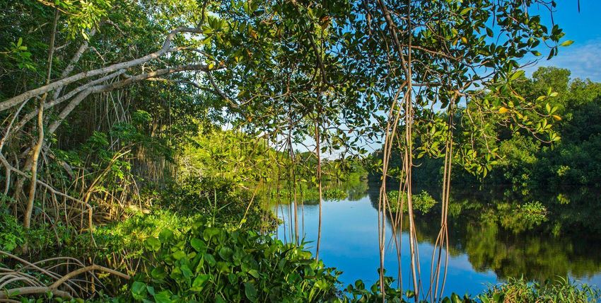
AI for Earth Grantee Profile
Scripps Institution of Oceanography
Monitoring mangrove deforestation in Mexico

Summary
Mangrove forests supply many ecosystem services, from fisheries to coastal protection, carbon sequestration,
and biodiversity. Mangroves are estimated to sequester up to 50 times more carbon than tropical rainforests,
but existing climate policies do not include mangrove protection. And in the last 50 years, between 30 and 50
percent of the world’s mangroves have been destroyed. Researcher Octavio Aburto of Scripps Institution of
Oceanography and his team, in partnership with Engineers for Exploration, are using drone technology and
machine learning to identify and monitor mangrove forests in Mexico to improve measurable conservation
outcomes globally. Aburto’s team is working closely with Mexican officials to assess mangrove coverage in all
regions in Mexico, to define mangroves as a protected habitat and to calculate the economic value of the
habitat’s ecosystem services. With machine learning and drone imagery they can evaluate mangrove
ecosystems on a local and global scale, providing stakeholders and decisionmakers with the data they need for
effectively management and conservation.

Monitoring the mangroves of Mexico with machine learning
As the threat of global climate change has become a common topic of discussion, so too has green become
the color of the day: green technology, green buildings, green energy, and many other uses of “green”
referring to practices and products that are environmentally friendly. Much less discussed is blue, specifically
blue carbon, which refers to the carbon captured from the atmosphere and stored by coastal ecosystems—blue
for the marine systems just as green alludes to terrestrial plant life. Although blue carbon is less familiar to the
general public, scientists have found these coastal ecosystems are at least as important for storing carbon as
the land-based forests that get much of the attention. Indeed, the IUCN notes that 83 percent of all global
carbon cycles through the ocean, and of that, as much as half of the carbon sequestered in ocean sediments is
captured by the mangroves, tidal marshes, and seagrass meadows of the coastal ecosystems—which cover less
than 2 percent of the ocean area. One recent study estimates that the mangroves of the Amazon store twice as
much carbon per hectare as the terrestrial Amazon forests; others, that mangroves in general can sequester up
to four times as much as rainforests, or more. (Overall, when including seagrass and salt marshes, coastal
habitats are estimated to store up to fifty times as much carbon per hectare as tropical forests.)

Scripps Institution of Oceanography, UCSD

Monitoring mangrove deforestation in Mexico                                                    Last updated: 6/28/2020
In addition to the carbon sequestration, mangroves offer several other important benefits in their ecosystems.
These include supporting biodiversity by providing a habitat for thousands of species, from microbes to plants
to animals, as well as by forming the basis of the habitat’s food chain. Many forms of sea life also use the
mangroves as a nursery, with the young animals sheltering amid the roots until they reach adulthood and are
ready to venture into the open ocean. And although life in the coastal ecosystems naturally centers on the

       “On average, one hectare of mangrove, 100 meters by
       100 meters, can provide around $100,000 dollars
       every year.”—Dr. Octavio Aburto, Scripps Institution of
       Oceanography, UCSD
ocean, the mangroves also help to stabilize the shore and protect the land from erosion and storms—while
protecting the ocean by filtering out pollutants, as well.

“If you put together all the values—fisheries, coastal protection, carbon sequestration, biodiversity, all these
services that mangroves provide—on average one hectare of mangrove, 100 meters by 100 meters, can
provide around $100,000 dollars every year,” explains Dr. Octavio Aburto, an associate professor with the
Scripps Institution of Oceanography at the University of California, San Diego (UCSD). Yet despite that value,
mangroves have decreased by 30 to 50 percent worldwide over the past fifty years, largely due to competing
economic interests causing the ecosystems to be destroyed. Mangroves are removed to build aquaculture
ponds for farming shrimp, or for planting palm trees for palm oil production. Tourism, the oil industry, and
other coastal developments, as well as sea level rise from climate change, all threaten mangrove ecosystems as
well. Currently, mangroves are being lost at the rate of 2 percent a year, and just as mangroves can store vast
amounts of carbon, so do they release all that carbon when they are destroyed.

Using drones and AI to map and monitor the mangroves

“The first time that I snorkeled inside the mangrove roots, I was amazed with all the life and beauty that I saw in
that ecosystem,” says Dr. Aburto. Since that time 25 years ago, Dr. Aburto has made mangrove studies a central
part of his research and has recruited students and colleagues to join him in expanding those studies. One of
those colleagues is Astrid Hsu, a former undergraduate student of Dr. Aburto’s and now a research associate at
the Scripps Institution of Oceanography (SIO).

“Doing traditional surveys for the mangroves, they are very dense, so walking through them is quite an ordeal
and trying to take measurements on the ground is a little bit chaotic,” says Hsu. The challenges of the
mangrove habitats make manual field surveys time consuming, labor intensive, and limited in scope. Due in

Scripps Institution of Oceanography, UCSD

Monitoring mangrove deforestation in Mexico                                                   Last updated: 6/28/2020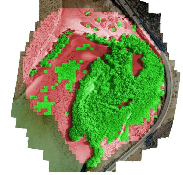
part to these challenges, thorough assessments of mangrove ecosystems are seldom performed—Mexico for
instance has been evaluating its coverage every five years—and that makes it difficult to monitor for and
respond quickly to any loss of mangroves. Although satellite imagery is now widely used for monitoring forests
around the world, currently the relatively thin layer of mangroves along coastlines is too difficult to distinguish
“In some places like northwest Mexico we have
estimated this 1 percent layer contains almost 30
percent of all the carbon in the region.”—Dr. Aburto
from other types of vegetation. Until the technology for using satellite imagery catches up to the resolution
needed for mangroves, Dr. Aburto’s lab is turning to a source of aerial imagery closer to Earth: drones.
“I was able to connect Octavio’s lab and Scripps in general with a group also at UCSD called Engineers for
Exploration headed by Dr. Ryan Kastner and Dr. Curt Schurgers,” explains Hsu, “and get these two teams
working together on how we could use technology to answer questions in ecology, to help with monitoring
efforts.” Dr. Aburto says, “The idea that we started with Astrid is that we use drones to fill the gap, work with
algorithms, work with team of researchers so all this information can be ready once we have enough resolution
with the satellites.” The two teams further worked with the local organization Centro para la Biodiversidad
Marina y la Conservación, A.C. in Mexico to conduct fieldwork and build local capacity.
The drones are flown over the mangroves at two
heights, 120 meters and 10 meters, taking
thousands of photos during the flight. The photos
in each set have a high amount of overlap, as
much as 80 percent on each side, to help create an
orthomosaic—a large composite image that has
been adjusted to compensate for distortions from
the camera lens itself, the camera tilt, and the
topography of the area being photographed.
These adjustments mean that the orthomosaic
presents a consistently scaled representation of the
area that accurately correlates the pixels of the
photos to their physical locations. By comparing
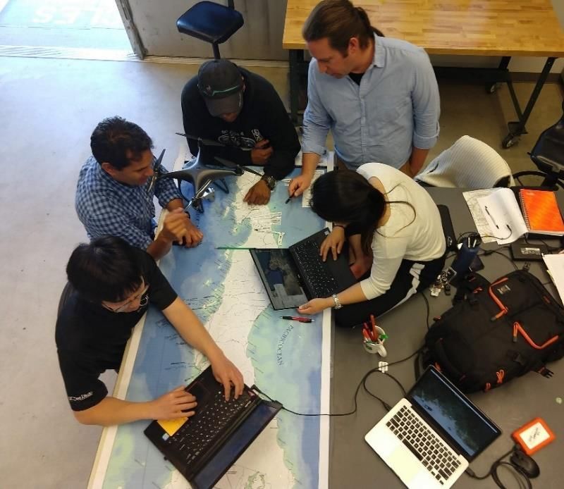
this data with field surveys, the researchers can Octavio Aburto and his team from Scripps Institution of Oceanography,
denote mangrove habitats from non-mangrove University of California San Diego, and Centro para la Biodiversidad
Marina y Conservación planning field flights
habitats in the images, creating datasets for
Scripps Institution of Oceanography, UCSD
Monitoring mangrove deforestation in Mexico Last updated: 6/28/2020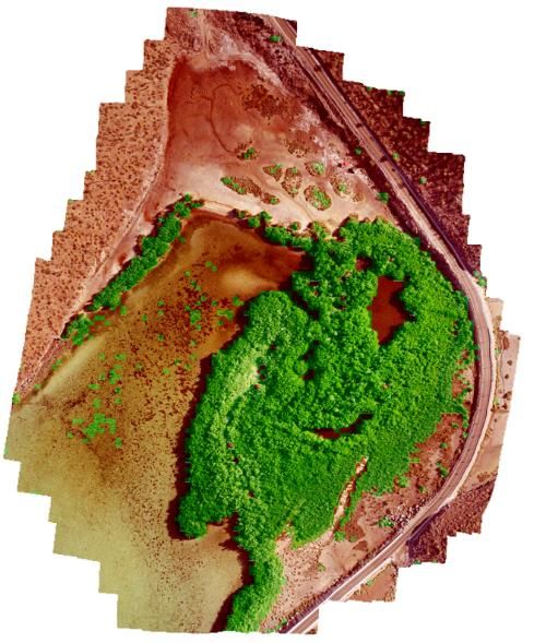
training machine learning models to automate that classification. Because the orthomosaic correlates the
photos to the topography, it also creates a three-dimensional model of the habitat. With that model, the team
can calculate the above-ground biomass of the mangrove and thus estimate how much carbon it has stored
both above and below the ground.

While the higher-level photos from 120 meters are used to document the extent of the overall habitat, the
lower-level photos from 10 meters can be used to identify mangrove species. In the Americas there are four
species of mangrove, commonly known as red, white, black, and buttonwood. Typically, they grow in zones
along the coastline, with the red mangroves first growing furthest out in the tidal area, forming a natural barrier
that then allows the white and the black mangroves to grow more inland. However, Dr. Aburto explains, as

                  Results of the first version (left) and improved version (right) of the support vector machine
                  algorithm for detecting mangrove/non-mangrove habitat

climate change causes sea levels and temperatures to rise, the locations and distributions of the different
species are changing as well, potentially affecting both which ecological services the mangroves can provide
and where. Teaching machine learning algorithms to distinguish the different species in the orthomosaics will
help scientists understand and efficiently monitor those changes.

Applying the research to conservation in Mexico—and around the world

“When it comes to machine learning applications, having to constantly run your models and retrain, train and
then retrain, it was all very time consuming and energy intensive and we were just nearing the limit that we had
physically at the University,” says Hsu. “Microsoft Azure has been a godsend in that way, enabling us to move
faster and farther then we would have otherwise.” Thanks to a National Geographic Innovation Grant in

Scripps Institution of Oceanography, UCSD

Monitoring mangrove deforestation in Mexico                                                                        Last updated: 6/28/2020
partnership with the Microsoft AI for Earth program, Dr. Aburto’s lab received funding, support, and access to Microsoft Azure computing and AI resources in the cloud. Dr. Aburto and his team have been working closely with several Mexican government organizations (such as the National Commissions of Protected Areas, of Water, and of Forestry) and the Mexican non-profit organization Centro para la Biodiversidad Marina y la Conservación, A.C. to support mangrove monitoring across Mexico, particularly in Baja California Sur. The various agencies all play roles in managing natural resources and habitats, and in helping Mexico meet its national and international climate-related commitments for sustainability. Regarding those sustainability commitments, Dr. Arbuto points out the outsized importance of mangroves: “Even this thin layer of mangroves that is 1 percent of the continent, in some places like northwest Mexico we have estimated this 1 percent layer contains almost 30 percent of all the carbon in the region.” By developing the machine learning algorithms for drone imagery and educating the government stakeholders in using the drones and image processing, Dr. Aburto’s team works to improve conservation efforts for the mangroves. “I dedicated a lot of time to evaluate the ecosystem services that mangroves provide for humans mainly in Mexico,” says Dr. Aburto, “but these ecosystem services transcend borders, transcend many regions.” A longer- term goal for the team is to make the mangrove recognition algorithms more broadly applicable, first to other regions of Mexico and then other areas of the world. Thus, the team has begun labeling images from mangroves in the Yucatan Peninsula and elsewhere, and training models to recognize more varieties. Eventually, they will create an open-access library on GitHub of their work so that other scientists and stakeholders have the tools to make better decisions for protecting and conserving mangroves. About Octavio Aburto Octavio Aburto is an Associate Professor at Scripps Institution of Oceanography (SIO), a professional photographer associate with the International League of Conservation Photographers, and a National Geographic Explorer. Aburto obtained his PhD at the Center of Marine Biodiversity and Conservation at SIO and was honored with the Jean Fort Award by the University of California, San Diego for his significant contribution to an issue of public concern through his doctoral research. As a Kathryn Fuller and Hellman Fellow, his research and photographs have focused on marine protected areas and commercially exploited marine species in Mexico, Belize, Costa Rica, Ecuador, and the United States. His photographs have been part of several conservation projects worldwide and have won international photography contests including a gold place in the Our World Underwater 2016. Scripps Institution of Oceanography, UCSD Monitoring mangrove deforestation in Mexico Last updated: 6/28/2020
About Astrid Hsu
Astrid is a marine biologist focused on understanding mangrove ecology and ecosystem services in Mexico. As
a research associate at the Scripps Institution of Oceanography (SIO), she collaborates and supports the work
of Dr. Octavio Aburto (aburtolab.ucsd.edu) and Dr. V. Ram Ramanathan (scripps.ucsd.edu/labs/ramanathan).
She earned both her B.S. in Marine Biology with a minor in Science Education and her M.A.S. of Marine
Biodiversity and Conservation at SIO, University of California, San Diego. She is a National Geographic Explorer
and specializes in interdisciplinary solutions, approaching issues such as marine conservation and climate
change from a myriad of approaches.

About Engineers for Exploration
Directed by Ryan Kastner, Curt Schugers, and Albert Lin, Engineers for Exploration is a group of students who
develop and use technology to drive the future of exploration. Their projects span aquatic, terrestrial, and aerial
environments, opening new perspectives of the planet. With international collaborators in ecology,
conservation, and archaeology, they apply remote imaging, sensing, and robotic technologies to extend the
limits of human exploration.

About Centro para la Biodiversidad Marina y la Conservación, A.C.
CBMC is an organization dedicated to generate scientific knowledge and facilitate its integration into the
processes of natural resource management and conservation of vital marine ecosystems such as rocky reefs,
seagrass beds, coastal lagoons, and mangrove forests; as well as species of commercial importance. They
incorporate technology into their research and strive to maintain simple and replicable methodologies, while
promoting the participation of local communities.

Resources
Websites
Dr. Aburto’s profile page for Scripps Institution of Oceanography, UCSD
Aburto Lab home site
Engineers for Exploration at UCSD home site
Centro para la Biodiversidad Marina y la Conservación, A.C.

Scripps Institution of Oceanography, UCSD

Monitoring mangrove deforestation in Mexico                                                   Last updated: 6/28/2020
Publications

Paula Ezcurra, Exequiel Ezcurra, Pedro P. Garcillán, Matthew T. Costa, and Octavio Aburto-Oropeza. “Coastal
landforms and accumulation of mangrove peat increase carbon sequestration and storage.” Proceedings of the
National Academy of Sciences. Apr 2016, 113 (16) 4404-4409. https://doi.org/10.1073/pnas.1519774113

Documentation
National Ocean Service. “What Is Blue Carbon?” National Oceanic and Atmospheric Administration. July 24,
2019. https://oceanservice.noaa.gov/facts/bluecarbon.html

“Blue Carbon”. IUCN Issues Brief. International Union for Conservation of Nature. November 2017.
https://www.iucn.org/resources/issues-briefs/blue-carbon

Daisy Dunne. “Amazon mangroves ‘twice as carbon rich’ as its rainforests.” Carbon Brief. September 5, 2018.
https://www.carbonbrief.org/amazon-mangroves-twice-as-carbon-rich-as-its-rainforests

Morgan Erickson-Davis. “New study finds mangroves may store way more carbon than we thought.”
Mongabay. May 2, 2018. https://news.mongabay.com/2018/05/new-study-finds-mangroves-may-store-way-
more-carbon-than-we-thought/

Jeremy Hance. “Coastal habitats may sequester 50 times more carbon than tropical forests by area.” Mongabay.
November 16, 2009. https://news.mongabay.com/2009/11/coastal-habitats-may-sequester-50-times-more-
carbon-than-tropical-forests-by-area/

The Ocean Portal Team. “Mangroves as Ecosystems.” Mangroves. The Smithsonian Institution. April 2018.
https://ocean.si.edu/ocean-life/plants-algae/mangroves#section_4026

“About Blue Carbon: What are blue carbon ecosystems?” The Blue Carbon Initiative. 2019.
https://www.thebluecarboninitiative.org/about-blue-carbon#ecosystems

Scripps Institution of Oceanography, UCSD

Monitoring mangrove deforestation in Mexico                                                Last updated: 6/28/2020
You can also read