ASIAN ALPINE E-NEWS Issue No 77. September 2020
←
→
Page content transcription
If your browser does not render page correctly, please read the page content below
ASIAN ALPINE E-NEWS
Issue No 77. September 2020
C CONTENTS
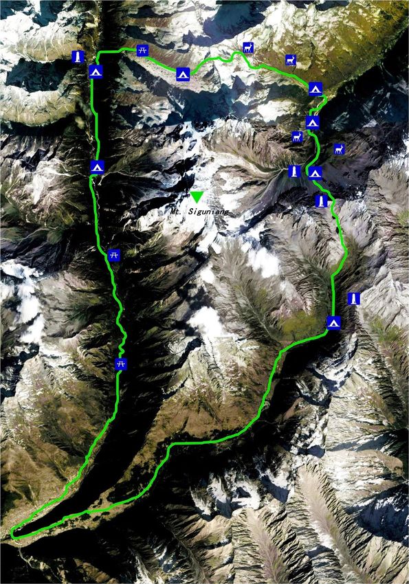
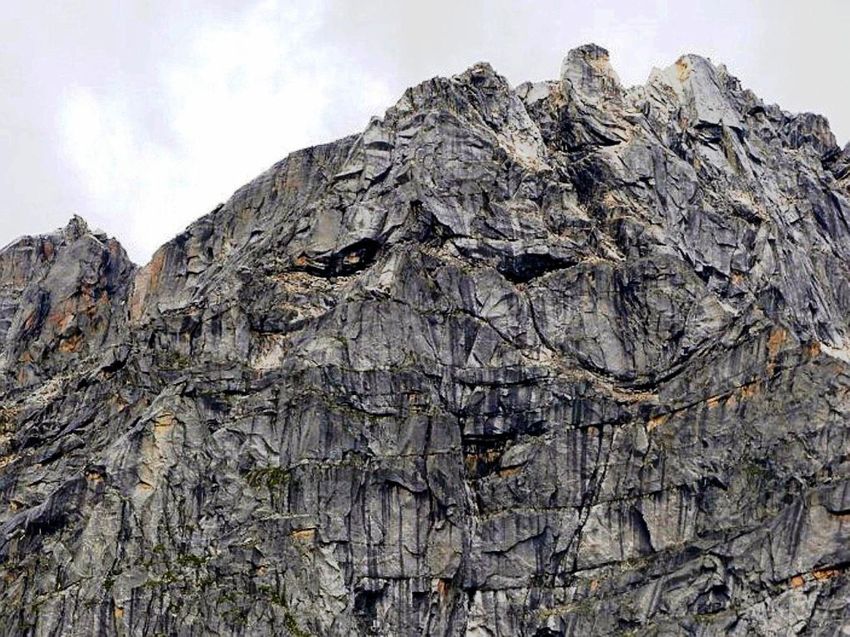
(Above picture: Mt. Siguniang 6250m South face)
Page
Circumnavigation around Mt. Siguniang Young Liu (Daliu) 2 ~ 16
The Salt Journeys in Tibet Santiago Lazcano 17 ~ 23
1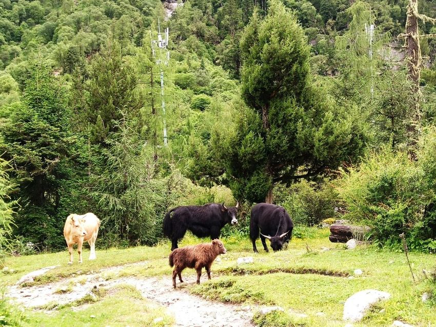
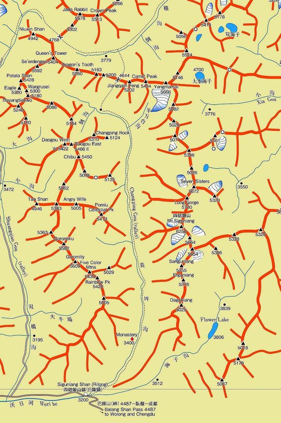
Circumnavigation around Mt. Siguniang Mountain Range

                      Young Liu (Daliu)

1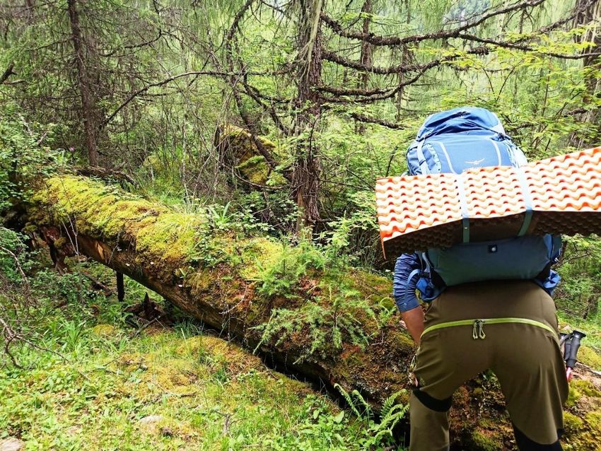
The original name of Siguniang mountain in Jiarong Tibetan language is
"Sikula mountain". According to the legend of Jiarong, there are four deities
of war and Dharma protection. Mt. Moredor is one of them. Because there
are four independent peaks of more than 5000 meters in length near the
2
main peak of Sikula, which are arranged from west to East, and the sound
of "squala" and "four girls" in Chinese is close, so climbers who came here
in 1980s began to call it "Siguniang mountain"

Siguniang mountain is located in the eastern edge of the Qinghai Tibet
Plateau, the first step of Chinese landform. It belongs to the transition zone
from Sichuan basin to Qinghai Tibet Plateau. It is located in Siguniangshan
Town, Xiaojin County, Aba Tibetan and Qiang Autonomous Prefecture,
Sichuan Province. It is the main peak of Qionglai mountains, 220 km away
from Chengdu. There are more than 250 snow-capped mountains with an
altitude of more than 5000 meters. It is a sacred place for alpine climbers.

I have been living in Chengdu 180 kilometers away from Siguniang
mountain for a long time. I started my climbing career in the Sikula area
since the 1980s. Over the past 30 years, my partners and I have completed
many explorations here. In spring and autumn, we have searched remote
mountain areas for unclimbed peaks; in winter, we have climbed the ice fall
in Shuangqiao valley and some other balleys; in summer, we have drifted,
camped and paraglided in the valley.

The mountain range is very large, with more than 600 square kilometers
connected with the surrounding mountains. Jiarong Tibetans have lived
here for generations, and I have made many Tibetan friends here. Since I
finished my Phd.degree in history from Sichuan University, I have been
working and doing scientific research in the University. My anthropological
research object is Jiarong Tibetans in the Sikula area.

After years of exploration and field researching, I have always had a dream
that I want to see the back of Sikula. However, it is no man's land, and few
people have ever been there.

The convid-19 virus in 2020 made the world press the pause button, and my
own life slowed down. I also had a long time to repair the physical damage
of my body from a base jump accident. At the same time, I have been
thinking about the exploration and academic life in the mountain area of
Sikula for 30 years. I realized that accidents would happen at any time in
my life, and some dreams in my heart must be fulfilled. In June, this area
was open to tourists again, soon I began to plan my expedition

Hu Fulin is my undergraduate student. He is also an experienced outdoor
sportsman. He often takes part in some mountaineering expeditions and is
also an amateur Adventure Guide. In 2019, he was also in my
anthropological field survey in this area.He was very interested in my plan
3
to search route around the Mt.Sikula. After hearing about my plan, he
was the first one to join in. The other two teammates are young Tibetan
guys Liu Gang and Wang Shunlin who live in Siguniang mountain. They
are also members of the local mountain rescue team. I invited them to join
my team.

According to the information and maps we have found, there is no man's
land in the east of the mountain. We don't know how long it will take? The
result of our discussion is that the whole trip may take 4 to 5 days, so we
need to prepare food for 5 days. We also needed to carry tents, sleeping bags,
warm clothes, cameras, drones, GPS, etc., so we asked three more local
people to help us to carry some food. In this way, our seven people expedition
team will be completed. It's rainy season in July in the Sikula mountain
area, but I don't want to delay any more. Who knows when the terrible virus
will roll up again!

Day1 Siguniangshan town changing Valley camping site

  It rained all the time in the morning of July 11. When the rain stopped at
2:00 p.m., we started from Siguniangshan town and started hiking from the
Lama Temple in changing valley. This is a hikking trail that people like
very much. There is an obvious trail. We walked very fast and hardly rest
on the road. Today, the whole journey is only about 15km. All of them are
walking in the beautiful canyon. The altitude is about 3200m to 3700m.
About five kilometers away, it is a tourist walk built by waterproof boards.
After that, we enter the forest. All the trails are made by horses and yaks.
Due to the rain, it is very muddy, and the team members are strong,
although we chatted and walked happily all the way, we arrived at the camp
unconsciously at six o'clock. There was a field environmental protection
station of the local government. There was a long-term resident of a
protection personnel. After approval, we were allowed to live in the
protection station in that night. There was a special kitchen where we could
live and cook. I had expected the food and fuel for five days, but the strong
team members ate the two dinners I expected on the first day. I realized
that we didn't prepare enough food. If we went down to no man's land, there
was no way to replenish food. We didn't know how many days we would
have to finish the whole journey. So we used our satellite phone to inform
our friends in Siguniangshan town and asked him to buy us more food and
fuel.They would send them to us on horseback the next day. This season is
the local rainy season, so it began to rain cats and dogs in the sky at night,
and we slept comfortably in the wooden house all night.
4
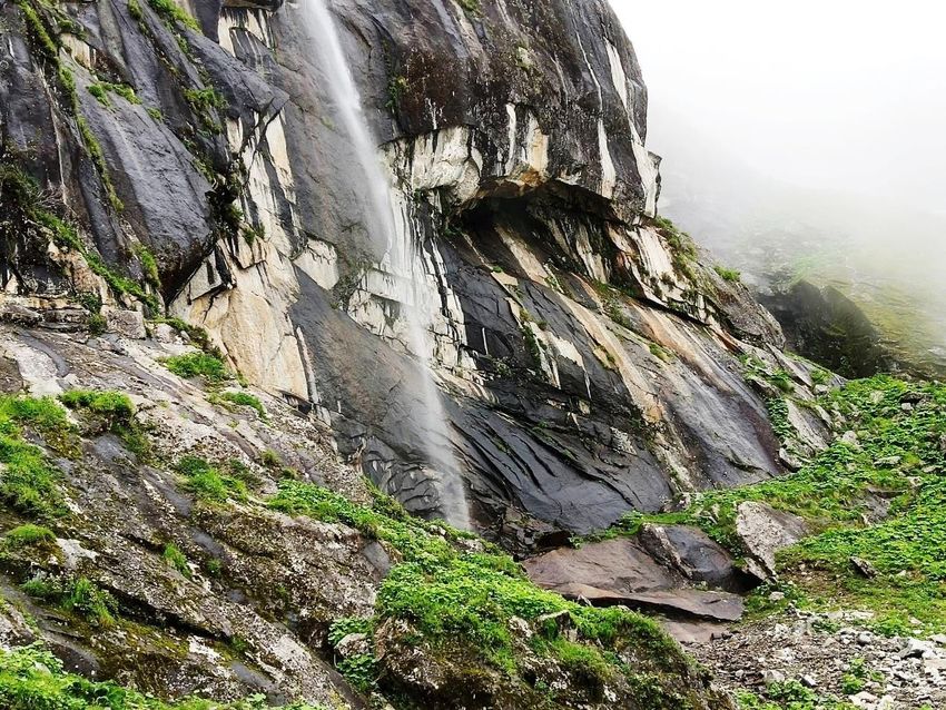
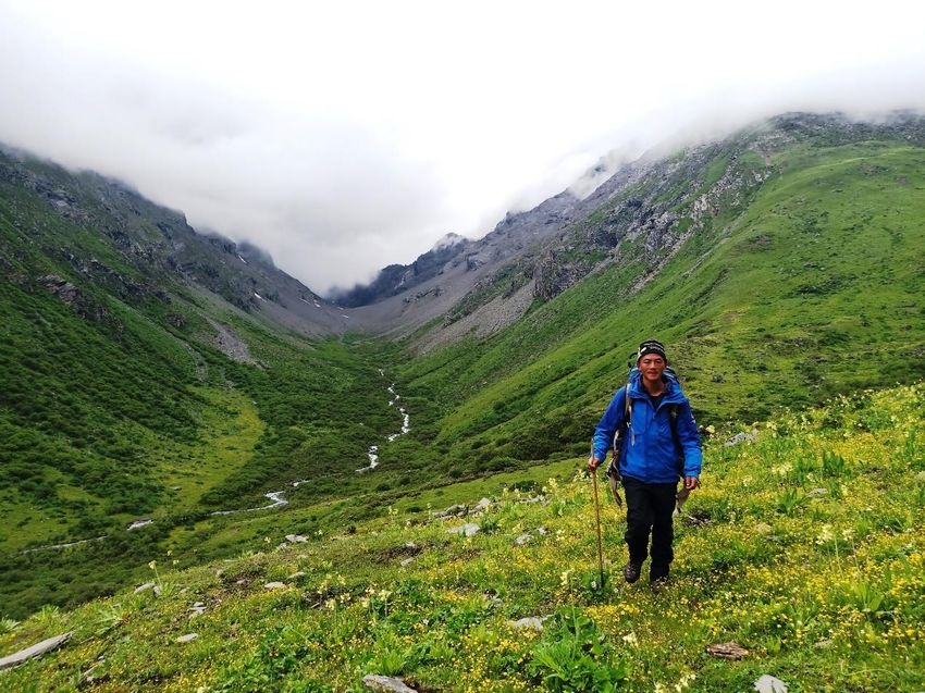
Day 2 Changping valley to Changgou camp site two(4400m)

The air in the valley was very good in the morning. After a night of heavy
rain, all the animals came out of the woods to drink water and eat grass by
the river. After breakfast, we took the camera and rushed to the grass to
take pictures for them. At about 09:00, our food was delivered, and we
started immediately after repacking. Each of us carried about 20kg
backpacks, including tents, sleeping bags, food, fuel, drinking water, clothes,
cameras, UAVs, satellite phones, etc. As it was raining all the time, we had
to wade through several wet swamps, along which there were some climbers
and hikers. After about an hour, we began to turn east and turn into a valley
called "Changgou Long Valley", and then we began to climb all the way up
the slope. This valley is really long, and the sea waves rise all the time. We
walked eastward along the path that yaks came out of. We had good luck.
Although it was covered in fog, there was no rain all the way. At about 18:30
p.m., we arrived at the camp at 4400 meters above sea level. This is a lawn
at the foot of the mountain. We observed the terrain, and there was a long
one from the middle of the mountain The gravel area has been extended to
the vicinity of the camp, but it seems that it should be a landslide caused by
the earthquake a long time ago. So, we decided to camp here. The next day,
we climbed over the 5000 meters mountain peak. As soon as we set up the
tent, the rainstorm came unexpectedly. After we got into the tent, we were
followed by lightning and thunder for several hours. Since I was injured for
several months, my training was irregular We felt that the journey was very
long today. Our body was very tired, and our companion Hu Fulin was also
very tired. So we drank some water and went to sleep listening to the
thunder. In the middle of the night, we heard the rumbling sound of rolling
stones in the distance of the tent. We didn't dare to fall asleep. We had to
endure the terrible thunder, lightning and rolling stones all night.

Day 3 Changgou to campsite three (3700m)

At six o'clock in the morning, I got out of the tent. The rain had stopped, but
there was thick fog everywhere. After we boiled water and ate some food,
we packed up the tent and set off quickly, because we didn't know where
our destination was today, but we had to cross the mountain northward and
enter the no man's land. The way to climb up is very steep. In some places,
it is more than 45 degrees, but we are all very fast. After about 3 hours, we
arrived at the pass. The altitude here is 5026 meters. After a short stay, we
started to go down from the other side of the valley. There are several very
5
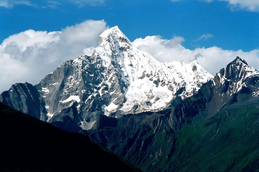
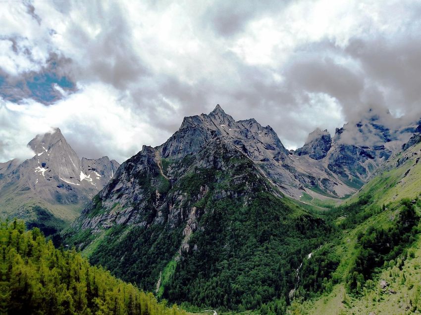
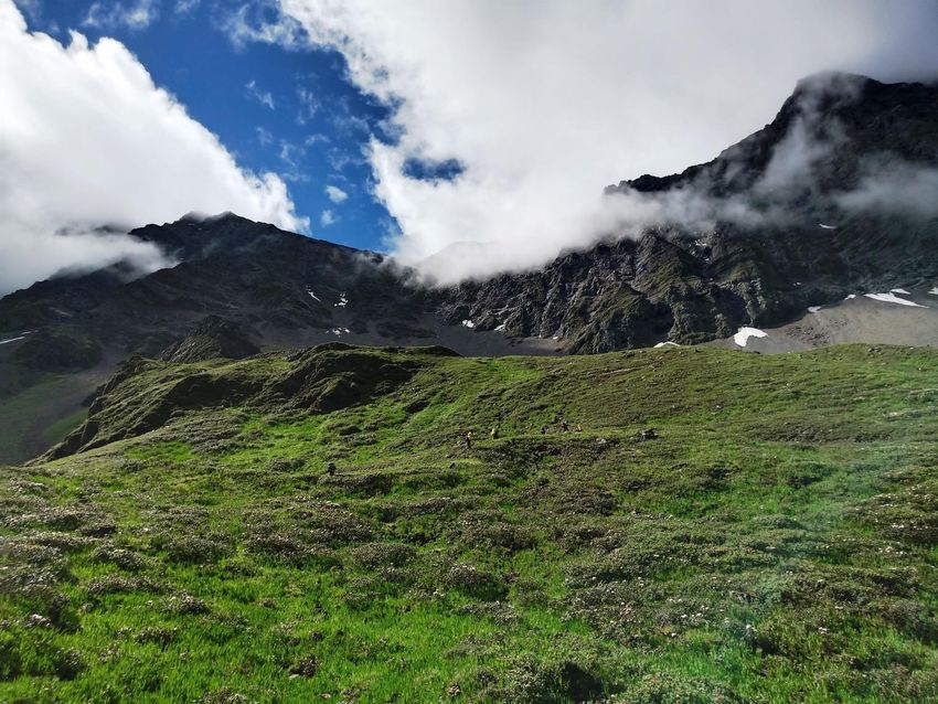
steep cliffs. We have to walk carefully. After that, we went back and descent
along the ridge, 4 hours after that, we came to a big river. This valley is no
man's land, and almost no one has been there. So, we saw many wild
animals, wild yaks, wild donkeys and foxes. Because of the weather &
location. there is no satellite signal here. At three o'clock in the afternoon,
the water was rushing down, so we could not find the way to cross the river.
We had to take off our shoes and trample on the cold snow water to cross
the river in order to find our way. After struggling for several hours, we
finally found a huge stone in the evening. We decided to camp here. We
found some dead trees, lit a fire, and slowly dried the wet clothes and shoes.
This boulder helped us to keep out the rain. We can cook and heat up here
until we get warm

Day4 Campsite to Haizigou valley hut(3800m)

Our luck came in the next morning. A brief sun appeared in the sky. We
saw the pass to be crossed from a distance and determined the position of
the pass. However, we were still a few hours away from it. After that, we
had to climb the slope for four hours,on the half way, we also had to take off
our shoes to cross the river. Finally, at 11:00 p.m., we arrived at the foot of
the mountain in wet. looked up the pass, it is very steep. After a while, the
top of the mountain began to be covered with fog. After drinking some water
and having a short lunch, we began to climb up. However, the steepness of
it was beyond my imagination. Some places were close to level 5 rock
climbing. Sometimes some falling stones rolled down from the fog above. We
had to stop and listen to the direction of the rocks to dodge, Slowly, we
groped to climb up, God bless us are on the right line. At about 2:00 p.m.,
we arrived at a very steep place, which is 80 degrees cliff. We had to cross
travers the past 20 meters, but we didn't carry the rope. Everyone had a big
bag, so we were very careful to slowly, because once we fell, under our foot
would be thousand feet abyss. Fortunately, there are some good foot points
and hand points. After we passed this section, we continued to climb up for
about 100 meters. Finally, we saw the pass, and we all cheered with
excitement. This pass is 4960 meters above sea level. Here, we can see the
outline of East face of Siguniang peak, although it is still hidden in the
clouds. After staying for half an hour, we began to retreat to the south side
of the ridge. Although it was still in the fog, the south side became not so
steep, but there were many snow pots. I stepped on the cracks of stones
several times and fell into the snow. Suddenly, from the fog, we saw a huge
high mountain lake. The blue water was surrounded by snow. It was very
6
beautiful. Later we checked the map and found that this was called
Shuanghaizi lake. We knew that we had crossed the no man's land and
reached Haizi Valley. This valley was named after many bright Haizi (high
mountain lakes). There were some paths made by local herbs and hunters
we went down the big trail and had to cross the river because the bridge
built by the local people was destroyed by the flood. At about 17:00 p.m., we
saw a cattle Herder's hut. After discussing with the owner of the hut, we
were allowed to live in it that night. That night, we made a table of delicious
food from the rest of our food, and then we slept by the fire at night, where
we could escape from the wind and rain, just like Noah's Ark. We knew that
we could finish the mountain turning line tomorrow, and everyone seemed
very relaxed. This day, we walked for about 10 hours&22km My shoes were
too small and inappropriate. My two big toenails hurt and my nails began
to turn black. After few days, I went back to Chengdu and went to the
hospital to remove them

Day 5 July 14th Dahuangpengzi Hut to Siguniangshan town

It was a easy day for us. Although we still had a distance of nearly 20
kilometers, the road had become very easy to walk. We could see beautiful
scenery along the road. We took photos all the way in Haizigou. My toes
hurt more and more. I limped out slowly and fell behind the team. Due to
the impact of the epidemic, there were almost no tourists here. We may be
the only one in the valley At two o'clock in the afternoon, we finally saw the
nature conservation station of Siguniangshan Administrative Bureau.
There were some people who went to hikking of Dafeng and Erfeng to rest.
After a short rest, we continued to go down. Finally, we walked out of the
moutain and returned to Siguniangshan town at 4:00 p.m.

We have finally successfully completed the hiking route around Siguniang
mountain. The whole route is more than 100 kilometers. We have crossed
two steep passes on the road. After talking with the local people and
inquiring with Mr. Nakamura of the Japanese Hengduan Mountain
Research Association, we believe that this is the first time that someone has
completely completed the Circumnavigation route around Mt.Siguniang
mountain range.

7
8
9
10
11
12
13
14
15
The Salt Journeys
    The Changthang and the Western and Central Himalayas
                     Santiago Lazcano

Salt has always been a fundamental product in the history of mankind.
Settlements would appear or die out in relation to their ease or difficulty in
accessing it. It also served as currency for commercial transactions, and its vital
importance is reflected in the term "salary" (derived from the Latin salarium),
which makes it possible for millions of people to satisfy their vital needs.

In the Tibetan and Himalayan context this importance is even greater. In Tibet,
salt is considered one of the "four pillars of life": tsampa, meat, salt and tea.
Tibetans are tireless drinkers of tea, which they mix with salt and yak butter. Its
excessive consumption, and the role of salt as a bargaining chip to obtain the so
necessary and scarce cereal, made it essential to obtain large quantities of the
product.

In ancient times, before the collision of tectonic plates originated the Himalayas,
the Tibetan plateau was covered by a great sea. The many salty lakes that are
reminiscent of it are the main deposits of such a precious commodity for Tibetans.
Salt consumed in western and central Tibet, as well as in Ladakh, Nepal and
Bhutan, was extracted from the lakes of the inhospitable Changthang (the high
and icy northern region of the plateau).

The salt harvesting
The nomads or Drokpas believe each lake is the heart of a Living Buddha, and they
also believe the lakes are the home of other local deities. When spring arrives,
around April, the Drokpas set out to the lakes in search of salt. It is an exclusively
male job. Women are not allowed to go to the salt lake. In each group in search of
salt, family roles are reproduced and each member is assigned a role to play. The
"father" is in charge of making offerings to burn, distributing the meat in the group
and visiting the stores to collect all the opinions if there is something to discuss.
The "mother" takes care of everyone and cooks and makes tea for them. The "son"
(bopu or bopsa) is the beginner and must learn from the elders how to extract the
salt, handle the tools, place the wool sacks on the animals, etc. The zopon or keeper
of the animals must find pasture and water for them, take care of them, and cure
them if they get sick.

The salt men must follow the established rules at all times. They must observe
good behavior among themselves and respect a series of prohibitions: it is forbidden
to have disputes and discussions, contact with women, meet imprudently with the
locals, and even that beggars, women and dogs spend the night near the camp.
They must also speak the "language of salt".

1
This "language" is more of a jargon or slang, consisting of the local dialect with some systematic changes made to make it incomprehensible to others, and with a lot of vocabulary known only to them. The "language of salt" contains many vulgarisms and also has a "spicy" or erotic connotation. Speaking this jargon during the expedition can be an excuse for the salt men to be able to talk about sex and joke about women without their dignity and social status being weakened. The Drokpas can take up to 20 days to reach the lake. The animals they drive to transport the salt on the return trip are usually yaks but they can also be sheep and goats. Yaks can carry about 30 kg. each one, about twice as many as sheep and goats. But these have the advantage of saving time for nomads, as once loaded with bags of salt they are no longer unloaded until they reach their destination. Upon reaching the lake, the nomads begin to break the salt into small pieces with yak or sheep horns, and accumulate it in conical piles with wooden scrapers. Later they fill the sacks and sew them. When they have all the salt collected, they bring the animals stayed grazing and load them with the sacks. Next day they start their return trip. The process of collecting salt in the lake usually takes about 8 days. After another long journey that takes them in their footsteps, men and animals loaded with salt arrive at their place of origin. Towards the Himalayas After a few months resting, another caravan is on the way again. It will take at least a month to reach the Himalayan slopes. Its objective is to exchange the salt obtained for products that do not exist in the Tibetan highlands: barley, wheat, leather, rice and vegetables. In pre-modern times (before 1950 and the Chinese administration), many routes would leave the solitary nomadic camps of the Changthang towards the high mountain passes of the south. Defying the dangers that threatened men and animals (bandits, wild animals, precipices and terrible temperatures) the caravan crossed them, and on the back of mules and yaks, the precious merchandise reached as far away as Baltistan, Ladakh, Kinnaur, the middle hills of Nepal, Sikkim, Bhutan and Mon-yul. The Tibetan government used to station salt tax collectors along the banks of the Yarlung Tsangpo, who would wait patiently at the ferry crossings that nomads necessarily had to cross to reach the Himalayan buttresses. The many routes leading to border markets necessarily had to overcome this obstacle. Once reached the last villages before the border, the Drokpas would exchange their merchandise with people from the other side of the passes who brought the coveted products of the south: vegetables, sugar, and especially barley, corn and wheat. These traders were generically called Bhotias, that is, culturally and linguistically Tibetan groups living on the Indian, Nepalese or Bhutanese side of the border. Between the Drokpas and the Bhotias, as well as between the Bhotias and the peoples further south, existed the institution known as "commercial friendship" or netsang: each 2
trader family had as partner another specific family among the other groups, with
which it traded in a preferential way and whose members acted as host when their
lands were visited. This relationship passed from father to son.

Himalayan markets
Diverse people from all corners of the southern tip of the Tibetosphere would
appear at these trade fairs, exchanging merchandise, ideas, news, dialects,
religious forms, and ways of life, thus revitalizing the cultural life of the Tibetan
civilization, which flowed vigorously through these business nodes. In addition to
the merchants, lamas, pilgrims, nomads, aristocrats, vagabonds and outlaws would
gather in the markets, as well as representatives of princes, monasteries and
Tibetan polities, giving vitality and appeal to these fairs.

From Purang under the holy Kailash, Tradün in the route to Mustang, Kyirong
and Rongshar north of Everest, or Phari in the Chumbi Valley, the Bhotias would
carry the salt up the high passes to take it home, store a little and resell the
remaining in more distant places. Further east, the salt reaching Bhutan and
Monyul came from the easternmost part of the Chagthang, from Nakchu and also
from the nearby Yamdrok tso Lake. Central Bhutanese would flock to Taklung
Tshondu, laden with rice, paper, brown sugar, bamboo, cloth, and medicinal herbs,
returning with salt, tea, silk, musk, gold dust, dried lamb feet, and sheepskins.
Tsona Dzong was also attended by merchants from northeast Bhutan, Assam and
mainly monpas from the Monyul corridor. Salt was exchanged here for rice, which
was highly valued by the Lhasa aristocracy and was a state monopoly in Tibet.

The arrival of modernity
In the 1950s with the extension of the Chinese administration over the territory of
the Dalai Lama, the exploitation of salt in Tibet, and especially its trade with the
southern slopes of the Himalayas, was drastically modified. The border was
hermetically sealed, disrupting the transnational salt trade and netsang
commercial friendly relations between families on both sides of the border. In the
following decade, the dark period of the Cultural Revolution also put an end to the
extractive and rituals practices of the salt men, in order to exploit the salt lakes in
"people's communes", using trucks for transportation. With the opening of the
eighties, the closure of some border crossings was minimally relaxed, and the salt
men were allowed to resume their traditional activity.

Caravans and the small-scale salt trade subsist today in some parts of the
Himalayas. But the exchange of large quantities and its generalization in the
region is now a thing of the past. Tibetan salt was replaced by Indian or Nepalese
iodized salt that arrived by helicopter and later through the new roads. Only the
taste and longing for Tibetan salt of the Himalayan peoples supports a small-scale
trade. The last caravans are approaching their extinction, and with them also

3
disappears the testimony of a way of life and a culture that marked the life of the
region for more than a millennium.

Kawachen, Land of Snow: Map made by Karl Ryavec of U.C. Merced (above)

4
Tsona and Tawang
“Source 2020 Lange, Diana, An Atlas of the Himalayas by a 19th Century
Tibetan Lama, p.235”

5
Yaks caravan carrying salt in snow

6
Above three photos: Lake Drabye 1, 2, 3

           Salt in Ogyen Choling

7
You can also read