ASSESSMENT OF COASTAL ENVIRONMENT SUPPORTS IN BATAM'S PEMPING ISLAND-INDONESIA FOR PIPELINE GAS TRANSMISSION
←
→
Page content transcription
If your browser does not render page correctly, please read the page content below
Sys Rev Pharm 2020;11(12):888-896
A multifaceted review journal in the field of pharmacy

     ASSESSMENT OF COASTAL ENVIRONMENT
 SUPPORTS IN BATAM’S PEMPING ISLAND-INDONESIA
        FOR PIPELINE GAS TRANSMISSION
MUBARAK, MUBARAK1*; NURHUDA, AHMAD2; SULAIMAN, ALBERTUS3;

1,2 UNIVERSITAS RIAU, FACULTY OF FISHERIES AND MARINE SCIENCES, DEPARTMENT OF MARINE
SCIENCES. INDONESIA.

3 AGENCY FOR THE APPLICATION AND ASSESSMENT OF TECHNOLOGY (BPPT), INDONESIA.

* CORRESPONDING AUTHOR
E-MAIL: MUBARAK@LECTURER.UNRI.AC.ID

ABSTRACT
                                                                            . Chemically, all parameters are below the standard quality
The coastal waters of Pemping Island in Batam have                          value, except phosphate and nitrate. Waves, tides, and
extensive biodiversity with an ecological system in the                     ocean currents are interconnected aspects based on
form of coral reef and mangrove ecosystems. The island is                   seasonal changes in the west and east. The average
significantly close to the international trade sea                          depth of the waters of Pemping Island is no more than 30
transportation routes. Currently, a gas pipeline                            m including a relatively low or shallow depth. Based on
construction is built on the island which might affect the                  observations of coral reef ecosystems are in the category
environment. This study is aimed to evaluate the coastal                    of damage due to the closure of coral reef ecosystems
waters of Pemping Island, Batam to preserve the marine                      which are dominated by abiotic and other biotics 80%
ecosystem from industrial development. The observation                      compared to live and dead corals by 20%. Mangrove
method was carried out by taking sample data directly                       vegetation on Pemping Island consists of two types of
from several research locations to test the quality of                      mangroves, namely Rhizophora mucronata which
seawater, coral reef ecosystems, and mangrove forests.                      dominates the number of mangrove tillers and Avicennia
Retrieval of data for aspects of waves, tides, currents, and                marina which dominates the mangrove stands at the
bathymetry using the help of satellite imaging systems.                     observation site.
Overall seawater quality has a value below the quality
standard with a depth of brightness measured up to 4 m                      Keywords: Coastal water, Coral reef, Environmental
above sea level.                                                            monitoring, Mangrove forests, Oceanography

INTRODUCTION                                                                location with quality raw materials that have been
                                                                            determined by the Minister of Environment Decree No. 51
          Batam island is an archipelago whose waters                       of 2004. Seawater movements such as waves, tides, and
border directly with Singapore’s strait where the strait is 15              currents affect activities around Pemping Island , Batam.
km wide and the free trade zone (FTZ) region separates                      This happens because of the morphological shape or
the two regions. Batam island has high economic and                         depth of the sea and the movement of wind speeds during
ecological dynamics in the form of the natural beauty of                    the east and west monsoons (Jeffrey 2002; Chust et al.,
waters and abundant biodiversity, especially in waters                      2010; Pugh and Woodworth, 2014; Lubis et al., 2018). The
(Delima et al., 2018). Batam waters have a major influence                  coral reef and mangrove ecosystems around Pemping
on the economic growth of the community as a sea                            Island , Batam are more dominant located in coastal areas.
transportation route for international trade in the                         These ecosystems have rich biodiversity and high
distribution of imported and exported goods (Faturachman                    productivity and have an important role in the survival of
et al., 2016). In addition, Batam has several areas with                    marine animals and plant organisms (Harold et al., 2009;
hidden potential in the form of natural energy reserves for                 Erik et al., 2008).
human needs that must be utilized as best they can
(Bachtiar and Putra, 2019). As currently in the Pemping                              The main objective of this study is to assess the
Island region around the waters of Batam has the                            environmental conditions of Pemping Island regarding gas
potential to contain energy sources in the form of natural                  pipeline construction in the location. The aspects to be
gas. Industrial development by the State Gas Company                        considered in the waters and coastal areas of Pemping
(PGN) in Pemping Island has been going on since two                         Island in Batam are the physical, chemical, and biological
years ago. Observation of the location of industrial                        environments as well as oceanographic variables. The
development needs to be done which is likely to affect the                  biological observation is focused on coral reef ecosystems
seawater ecosystem around Pemping Island Batam.                             and mangrove forests. These research reports can be
         Seawater quality is a water parameter in physical                  used to the stakeholders in for guidance the island
and chemical aspects that is very important for the survival                development and possible impact on the environment.
of marine animals and plant organisms (Kammer et al.,
2010). Seawater quality observed consists of several                        2. MATERIALS AND METHODS:
materials in different seawater content at each water

888                                                      Systematic Reviews in Pharmacy      Vol 11, Issue 12, December 2020
Assessment Of Coastal Environment Supports In Batam’S Pemping Island-Indonesia For
Pipeline Gas Transmission
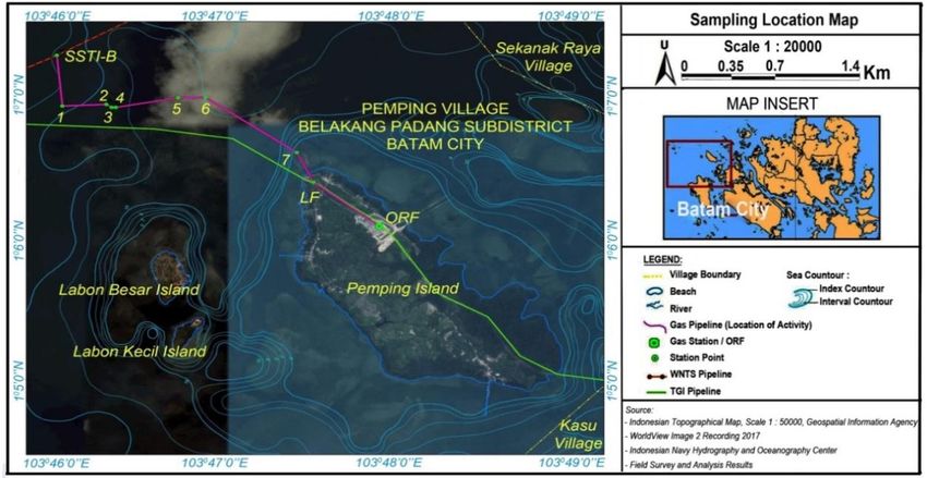
2.1. STUDY LOCATION
Gas pipeline construction and operation activities
Pemping Island is administratively located at from the West Natuna transportation system (WNTS)
Batam city with geographical coordinate of 1° 5' 47.7276'' pipeline to Pemping Island can affect oceanographic
N and 103° 39' 43.3656'' E. This island is covered a land parameters in the form of the formation of total suspended
area of 4.25 km2 and surrounded by 165.74 km2 sea solid (TSS). To analyze TSS, modeling technology for
region. Figure 1 shows the location of Pemping Island. ocean waves, tides, currents, and bathymetry is needed.
These parameters are explained as follows.
2.3.1 OCEAN WAVE
Retrieval of data about sea waves obtained from
journals, articles, and other documents that have been
studied in Batam waters from previous studies (Nurhuda et
al., 2019; Bachtiar dan Putra, 2019; Lubis et al., 2018).
Data tracking is done by accessing satellite imagery via
the internet source, such as the Center for Environmental
Modeling, NOAA Wave Watch III.
2.3.2 Tides
Tidal data collection is carried out to determine
the pattern of sea-level rise and fall and validation of the
results of the hydrodynamic model for the benefit of
estimated impacts in the study area. Tidal data were
obtained from the Indonesian Navy's Hydrographic and
Oceanographic Center (PUSHIDROSAL), in Batam waters
with AG95 developed by Andersen et al. (1995).
Figure 1. Map of Pemping Island , Batam city-Indonesia.
2.3.3 Currents
2.2. Catchment location The current pattern was obtained using the
modeling and the results are explained descriptively (Ortiz-
In order to evaluate the seawater quality, we collect Royero, et al., 2008; Borgman, 2012). The water flow
seawater samples form three locations as shown in Table patterns at the site were carried out by making flow
1. All locations are located around the gas pipeline modeling simulations from bathymetry, wind, and tidal data
construction. The following table is coordinate points of as the boundary conditions of the domain model
catchment of seawater samples. (hydrodynamic model). The result of the current modeling
process is an estimate of high and low tides due to
Table 1. Location coordinate of sea water catchment. extreme flow patterns. Modeling results are presented with
Point Latitude Longitude four tidal conditions consisting of before the highest tide,
St 1 㖸o 㖸㖸' th t'' 㖸 o t'㖸㖸h '' the highest tide, before the lowest tide, and the lowest tide.
St 2 㖸o 㖸㖸' h '' 㖸 o t' h '' Modeling is made by differences or grid systems (Lyard,
St 3 o '
㖸 㖸㖸 㖸h t'' 㖸 o ' th '' 2006).
The seawater samples are carried out directly 2.3.4 Bathymetry
from the field as primary data. Seawater is sampled using
a van dorn air sampler at a depth of half of the sea level The bathymetry can be used to describe the depth
(van Dorn, 1953). Samples are then put into cleaned characteristic of the beach and ocean floor. Bathymetry
bottles and grouped according to the type of parameters data at the study site was collected from the map created
analysis. The seawater treatment such as filtering and by PUSHIDROSAL. The location is the sea waters around
preservation is carried out according to standard the pipe which will be the location of the pipe installation.
procedures to avoid contamination. All bottles that have The results of data processing from PUSHIDROSAL
been filled with samples are stored in a cooler which will Indonesia will be visualized in the form of 2-dimensional
then be taken to the laboratory for analysis (Rubio et al., and 3D images (Muhari et al., 2019). From the picture then
2015; Cole et al., 2014). The parameters measured in a descriptive analysis is carried out regarding the depth
water quality follow the regulations based on the Republic conditions of these waters.
of Indonesia's Minister of Environment Decree No. 51 /
2004 concerning quality standards for seawater quality for 2.2. Biological parameter
marine biota.
The evaluation parameters, i.e. physical and The dominant part of the biological environment
chemical variables, are measured and analyzed by on the coast of Pemping Island, Batam is the coral reef
standard methods. the physical variables, such as turbidity, ecosystem and mangrove forests. The following is an
brightness scale, and temperature, are directly measured. explanation of the methods applied in this study.
Meanwhile, the chemical analysis was performed in the
laboratory by atomic absorption spectroscopy (AAS) 2.2.1 Coral reef
(Krammer et al., 2010).
Table 2. Coral reef observation stations in the study area.
2.3. Oceanographic parameters Stations Coordinate Depth Distance to the
889 Systematic Reviews in Pharmacy Vol 11, Issue 12, December 2020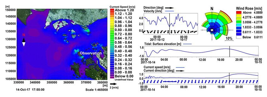
Assessment Of Coastal Environment Supports In Batam’S Pemping Island-Indonesia For
Pipeline Gas Transmission
position (m) pipeline Figure 2. Plot line method scheme for mangrove data
(m) collection (Decree of the Minister of Environment No. 201,
1.1240 N ; 2004).
1 3 800
103.7751 E
1.1096 N ; Retrieval of data and information about mangrove
2 8 30 ecosystems including distribution, area, and condition of
103.7908 E
1.1075 N ; mangroves (density and coverage). The method of
3 5 100 observing mangrove ecosystems is to make a plot transect
103.7911 E
1.1105 N ; with a size of 10 × 10 m, then count the number of stands,
4 9 100 tillers, and tree seedlings and then analyze to get the
103.7915 E
value of species density, important value index, and
The coral reef ecosystem data collection method dominance of uniformity. Figure 2 shows the pattern of
is carried out by the line intersect transect (LIT) method at transect plot measurements of mangrove plant
the identified and determined locations presented in Table ecosystems.
2. The LIT method draws biophysical data on coral reefs
along the transect line with a transect length of 0 – 100 m Notes that A is a plot for the seedlings and shrubs
and is parallel to the line beach. The transect line starts (1 × 1 m2), B is a plot for the peg (5 × 5 m2), and C is a plot
from the depth at which coral reefs are still found (± 25 m) for the tree (10 × 10 m2). To detect the presence,
to the beach following the contour line depth pattern. The distribution, and extent of mangrove ecosystems, satellite
determination of sample points is done by field surveys to image analysis was carried out, with a minimum spatial
determine the type, cover, and condition of coral reefs. resolution of 15 × 15 m. The results of satellite imagery
Sampling for coral reef ecosystems is carried out in the analysis are used to determine the sampling location, with
range of 0 – 25 m in the area of the gas pipeline a sample of 2 observation points at the location of the
approaching the coast. The method of analyzing coral reef planned activity.
data in the study area was obtained from direct
observation at several stations representing the planned 3. Results AND DISCUSSION:
pipeline location and not passing through the reef area.
3.1. Quality of seawater
2.2.2 Mangrove forests
Seawater quality measurements are divided into
two categories i.e. physical and chemical parameters in
the samples taken from the observation stations.
Table 3. Sea water quality is based on physical properties around the location of the activity.
Result
Parameters Quality Standards *) Unit
St 1 St 2 St 3
Brightness (In situ) Coral > 5 / Mangrove: - 4.0 4.0 4.0 m
Smells (In situ) Natural No Smell No Smell No Smell -
Turbidity
Assessment Of Coastal Environment Supports In Batam’S Pemping Island-Indonesia For
Pipeline Gas Transmission
*) Based on Decree of Minister of the Environment No. 51, 2004
3.1.1 Physical parameters
The results of in situ measurements and ex-situ
(laboratory analysis) of several physical parameters
measured at the three observation stations is shown in
Table 3. The physical parameters of water quality, such as
turbidity and TSS values are still below the quality
standard. As for the brightness parameters measured up
to a depth of 4 meters from the surface of the water.
Based on visual observations, no trash or oil spills were
found around the surface of the sea..
3.1.2 Chemical parameters
Based on the results of laboratory analysis of
twenty chemical parameters of seawater including Figure 4. Concentation of ammonium, phosphate, nitrate,
dissolved metals in Table 4, it is obtained that the and anion surfactants at the three stations.
condition of the waters in the study area, in general, is still
relatively good and meets environmental quality standards. 3.2. Oceanographic findings
Several chemical parameters are known to not meet
quality standards including nitrates and phosphates, while The oceanographic analysis was divided into
the content of dissolved metals is still below the quality several parameters that can be observed such as waves,
standards. tides, and currents influenced by several natural
environmental factors that will be explained below.
3.2.1 Sea wave
The wave characteristics that occur during the
west monsoon season (December – February) are
relatively higher, on average, 0.3 – 0.6 m from the
Malacca strait and the north Natuna Sea to the south.
Wave heights found on the east side crossing Pemping
Island, Batam range from 0.4 to 0.67 m, and the west side
reaches between 0.3 to 0.5 m. While in the east monsoon
season (June – August) the height of the sea waves has
decreased by 25%, increasing between 0.3 – 0.46 m
Figure 3. Dissolved oxygen (DO) and biological oxygen moving from the waters of Java and the north Natuna sea
demand-5 (BOD5) levels. towards the Malacca strait.
Based on Figure 3, it can be seen that the results 3.2.2 Tides
of DO and BOD5 levels from each sample taken at the
observation station point have good results. This shows
that the observation station waters have a low level of
pollution with the amount of oxygen dissolved in the
waters sufficient for marine organisms and biota in their
Figure 5. Tidal cylce in Batam waters during September
survival (Sarina et al., 2003; Wei et al., 2008; Mubarak et
2017 recording (Ministry of Maritime Affairs and Fisheries,
al., 2017).
2017).
The concentration of ammonia and anion The types of tides in the waters of Pemping
surfactant of all samples has still met the standards as Island, Batam are semidiurnal type, which is two pairs of
presented in Figure 4. Also, seawater in the study area the ebb and the flow in one day as depicted in Figure 5.
has high nitrate and phosphate concentrations based on The recorded tidal events have a phase difference of one
observations at three stations where values exceed hour from the time before and after. The highest tide
seawater quality standards for biota the sea. The high occurs around 22:00 – 23:00 at night with a peak height of
nitrate and phosphate content can indicate that these 1.4 m which occurs on September 19, 2017. The lowest
waters have a high fertility rate with nitrates which are rich tides occur on September 19, 2017, around 3:00 to 4:30 in
in organic matter (Sigua et al., 2017). the morning, with a low tide about – 1.5 m. Tides and tidal
times are accompanied by currents that are stronger than
usual (Bray et al., 1996).
3.2.3 Currents
In general, the pattern of tidal currents in the
Singapore Strait that occurs when the tide moves from the
direction of the pacific ocean through the waters of the
north Natuna Sea to the west. Conversely, at low tide, the
891 Systematic Reviews in Pharmacy Vol 11, Issue 12, December 2020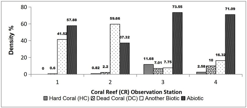
Assessment Of Coastal Environment Supports In Batam’S Pemping Island-Indonesia For
                                            Pipeline Gas Transmission
water mass moves outside Malacca strait (in the west) to         northeast with a percentage of 20% reaching more than
Pacific ocean (in the east) through north Natuna Sea. Tidal      4.8 m/s. While at sea level heading for the highest tide, the
patterns in the waters around the activity site are shown in     mass movement of water moves backward. The mass of
Figure 6 and Figure 7. The figures show the pattern of           water in the strait on Pemping Island is seen moving
current sea level compilation towards the lowest tides,          towards the west at speeds reaching > 1.2 m/s. When sea
where the current moves east towards the Singapore strait        level is at the highest peak position, there is relatively no
with the current velocity at the monitoring stations at < 0.7    movement of the air mass. The direction of the wind
m/s.                                                             moves very dominantly to the southeast with a percentage
                                                                 of 40% reaching a speed of 6.5 m/s.
         The dominant wind direction moves towards the

                                           Figure 6. Current patterns at low tide.

                                           Figure 7. Current patterns at high tide.

3.2.3 Bathymetry                                                 m. The sea area north of Batam island has a depth of
                                                                 between 4 – 25 m with slightly undulating morphology. The
          The bathymetry map across Pemping Island               beach around Pemping Island, which borders directly with
which is the location of the pipe installation is presented in   the Singapore strait, has a sea-level not exceeding 25 m
Figure 8 below. Based on the bathymetry map of the               around Pemping Island.
Batam waters, morphological forms, and contour patterns
with relatively low (shallow) sea depths of no more than 30

892                                        Systematic Reviews in Pharmacy            Vol 11, Issue 12, December 2020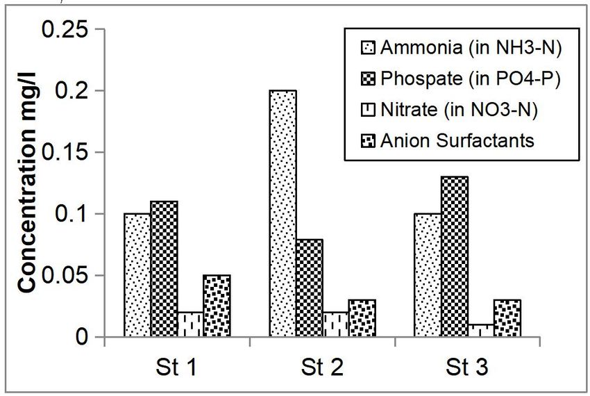
Assessment Of Coastal Environment Supports In Batam’S Pemping Island-Indonesia For
                                           Pipeline Gas Transmission

                                      Figure 8. Map bathymetry location of activities.

                           Figure 9. Conditions for coral reef closure at the observation station.

3.3 Coral reef ecosystems                                       while Rhizophora is in the middle of mangrove vegetation.

         The observations in Pemping Island waters found                 The mangrove density which depicted in Figure
that around the coral reef consists of live coral or hard       10 is the number of species stands per unit area. The
coral, dead coral, biotic or other algae, and abiotic. Figure   number of tree stands on Pemping Island for stations 1
9 is shown the results of observing coral reefs around the      and 2 is in the range 325 – 350 individual/hectare, while
observation station.                                            the number of tillers is in the range of 400 – 1,200
                                                                individual/hectare and 12,500 – 30,000 individual/hectare
         Coral reefs were found at the observation site         Seedlings. Based on the standard criteria for mangrove
within 0 – 100 m of the planned pipeline location. The          damage in Decree of the Minister of Environment No.
highest live coral (in form HC) was found at Station 3 at       201/2004, Pemping Island's mangrove forests are
11.68% which is 100 m from the pipe distance. While the         damaged due to sparse density.
lowest HC closure of 0.82% is at station 2 within 30 m of
the planned pipeline. While at station 1 no coral reefs were
found. Based on these results with the condition of coral
cover < 25%, this is categorized as a damaged condition
as referred to in decree of the Minister of Environment No.
04 of 2001 concerning standard damage criteria for coral
reefs.

3.4. Mangrove ecosystems

         The types of mangroves found on Pemping Island
are Rhizophora mucronata and Avicennia marina around
coastal, from basic mud to sandy mud (Dharmawan and
Widyastuti, 2017). Based on Saenger's decision (1998)
that the position of Avicennia species is near the sea,

893                                       Systematic Reviews in Pharmacy          Vol 11, Issue 12, December 2020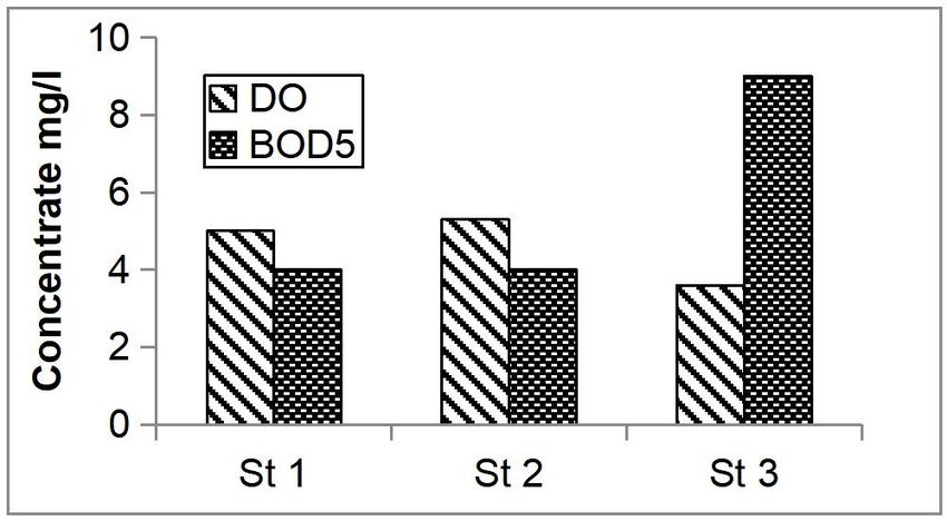
Assessment Of Coastal Environment Supports In Batam’S Pemping Island-Indonesia For
Pipeline Gas Transmission
4. CONCLUSIONS:
The environmental monitoring of Pemping Island
as impact of gas transmission construction has been
conducted. Based on the results of seawater quality
measurements at three stations, it is obtained that the
physical and chemical parameters of sea water are still
met with the standard. However, nitrate and phosphate
content are exceeded the quality standard for sea water by
60% and 80%, respectively. Sea wave characteristics are
generally based on changes in the monsoon season west
and east. The current pattern that occurs in the waters of
Batam follows the process of tides. Pemping Island waters
have relatively low or shallow sea depths with an average
depth of no more than 30 m with slightly undulating
morphology. Closure of coral reefs in the 4 stations is
(a) dominated by abiotic and other biotas with an average of
80%. Compared to dead and live corals, coral cover areas
have an average below 20%. The types of mangroves
found on Pemping Island are Rhizophora mucronata
dominating tillers and Avicennia marina dominating
mangrove stands the number of stands in the form of trees
and tillers from two mangrove species each is 675
individuals/hectare and 1600 individuals/hectare from 2
stations in the study location observation.
5. ACKNOWLEDGMENTS:
The authors express many thanks PT Umarai
Riau Consultant for funding this research (Grant No.
014000.PK/HK.02/PMIII.2/2017) as well as PT PGN in
research collaboration. The authors are also grateful to the
Universitas Riau for providing some facilities.
6. REFERENCES:
(b)
Figure 10. The importance value index of (a) 1. Andersen, O. B.; Woodworth, P. L.; Flather, R. A.
mangrove tree dan (b) mangrove tillers on Pemping Island (1995). Intercomparison of recent ocean tide
models. Journal of Geop;ysical Research,
The structure of mangrove vegetation can be 100(C12), 25261-25282. doi:10.1029/95jc02642.
arranged using the diversity index (H'), uniformity index (E),
domination index (C) and importance value index (IVI). 2. Bachtiar, I. K.; Putra, R. D. (2019). OTEC
Important value indices are used to provide an overview of Potential Studies For Energy Sustainability In
the role or role of mangrove species in ecosystems. IVI Riau Islands. 2019 6th International Conference
values range from 0 – 300 for trees and 0 – 200 for on Electrical Engineering, Computer Science and
seedlings and saplings (Rachmawania et al., 2016). Informatics (EECSI).
doi:10.23919/eecsi48112.2019.8976969.
Further analysis of the IVI value shows that the
3. Borgman, C. L. (2012). The conundrum of
number of Avicennia marina trees is higher in Pemping
sharing research data. Journal of the American
Island mangrove ecosystem. While, the density of
Society for Information Science and Technology,
Rhizophora mucronata saplings is highest in the mangrove
63(6), 1059-1078. doi:10.1002/asi.22634.
ecosystem.
4. Bray, N. A.; Hautala, S.; Chong, J.; Pariwono, J.
Table 7. Diversity index (H '), uniformity (E), and
(1996). Large-scale sea level, thermocline, and
dominance (C) of mangroves.
wind variations in the Indonesian throughflow
Station H’ E C region. Journal of Geophysical Research:
1 0.26 0.75 0.66 Oceans, 101(C5), 12239-12254.
2 0.27 0.89 0.57 doi:10.1029/96jc00080.
Mangrove dominance at station 1 is the higher 5. Cole, M.; Webb, H.; Lindeque, P. K.; Fileman, E.
compare to station 2 as seen in Table 7. The dominace S.; Halsband, C.; Galloway, T. S. (2014).
index in station 2 is 0.57. This means that the uniformity of Isolation of microplastics in biota-rich seawater
mangrove species at station 2 is higher as indicated by samples and marine organisms. Scientific
uniformity value of 0.89. Lesley and Nola (1971) reports Reports, 4(1), 4582. doi:10.1038/srep04528.
that the increasing in uniformity will eliminate the
dominace in mangrove forests.
894 Systematic Reviews in Pharmacy Vol 11, Issue 12, December 2020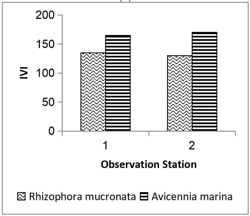
Assessment Of Coastal Environment Supports In Batam’S Pemping Island-Indonesia For
                                           Pipeline Gas Transmission
      6.   Decree of the Minister of state Environment               of the Ocean to Global Climate Change
           Number 201. (2004). Standard Criteria and                 Variability: Case Study in The Batam Waters,
           Guidelines for Mangrove Damage Determination,             Indonesia. 2018 International Conference on
           Minister of Environment, Indonesia.                       Applied           Engineering         (ICAE).
                                                                     doi:10.1109/incae.2018.8579397.
      7.   Decree of the Minister of state Environment
           Number 4. (2001) Standard Criteria for Coral          18. Lyard, F.; Lefevre, F.; Letellier, T.; Francis, O.
           Damage, Minister of Environment, Indonesia.               (2006). Modelling the global ocean tides: modern
                                                                     insight from FES2004. Ocean Dynamics, 56, 394-
      8.   Decree of the Minister of state Environment               415.
           Number 51 (2004)Raw Quality of Seawater,
           Minister of Environment, Indonesia.                   19. Ministry of Maritime Affairs and Fisheries, (2015).
                                                                     RZWP3-K: The Formulation Support Document
      9.   Delima, S. P.; Moersidik, S. S.; Wirutomo, P.;            (Zoning Plan for Coastal Areas and Small Islands)
           Alamsyah, A. T. (2019). Integrating Human                 in Batam City-Riau Archipelago Province,
           Ecology into Sustainable Development to                   Indonesia.
           Address Potencies and Challenges of the City of
           Batam as a Port City. Proceedings of the 2nd          20. Mooney, H.; Larigauderie, A.; Cesario, M.;
           International Conference on Strategic and Global          Elmquist, T.; Hoegh-Guldberg, O.; Lavorel, S.,. .
           Studies (ICSGS 2018). doi:10.2991/icsgs-                  Yahara, T. (2009). Biodiversity, climate change,
           18.2019.8.                                                and ecosystem services. Current Opinion in
                                                                     Environmental     Sustainability,  1(1),  46-54.
      10. Dharmawan, I. W.; Widyastuti, A. (2017). Pristine          doi:10.1016/j.cosust.2009.07.006
          Mangrove Community In Wondama Gulf, West
          Papua, Indonesia. Marine Research in Indonesia,        21. Mubarak, Sutikno, S., Merian, R. D. (2017).
          42(2), 73-82. doi:10.14203/mri.v42i2.175.                  Numerical model for pollutant dispersion in the
                                                                     Dumai estuary. MATEC Web of Conferences,
      11. Faturachman, D.; Dewanto, Y. A.; Adiatmojo, G.             101,      Article    ID       04001,       doi:
          D. (2016). Safety Analysis of Sea Transportation           10.1051/matecconf/201710104001
          in Indonesia Case study: Crossing Between
          Countries In Sumatera Island (Batam -                  22. Muhari, A.; Heidarzadeh, M.; Susmoro, H.;
          Singapore). International Journal of Advances in           Nugroho, H. D.; Kriswati, E.; Supartoyo;
          Mechanical & Automobile Engineering, 3(1), 80-             Wijanarto, A. B.; Imamura, F.; Arikawa, T. (2019).
          84.                                                        The December 2018 Anak Krakatau volcano
                                                                     tsunami as inferred from post-tsunami field
      12. Harold, M.; Anne, L.; Manuel, C.; Thomas, E.;              surveys and spectral analysis. Pure and Applied
          Ove, H. G.; Sandra, L.; Georgina, M. M.;                   Geophysics, 176, 5219-5233.
          Margaret, P.; Robert, S.; Tetsukazu, Y. (2009).
          Biodiversity, climate change, and ecosystem            23. Nurhuda, A., Mubarak, Sutikno, S. (2019).
          services. Current Opinion in Environmental                 Analysis of coastal vulnerability of Rangsang
          Sustainability, 1(1), 46-54.                               Island due to climate changes. Journal of
                                                                     Degraded and Mining Lands Management, 6(4),
      13. Jeffrey, S. D. (2002). Bedform migration and               1907-1914. doi: 10.15243/jdmlm.2019.064.1907
          sediment dynamics in the nearshore of a low-
          energy sandy beach in southwestern Australia.          24. Ortiz-Royero, J. C.; Mercado-Irizarry, A. (2008).
          Journal of Coastal Research, 18(3), 576-591.               An Intercomparison of Swan and Wavewatch III
                                                                     Models with Data from NDBC-NOAA Buoys at
      14. Kammer, F. V. D;, Ottofuelling, S.; Hofmann, T.            Oceanic Scales. Coastal Engineering Journal,
          (2010). Assessment of the physico-chemical                 50(1), 47-73. doi:10.1142/s0578563408001739.
          behavior of titanium dioxide nanoparticles in
          aquatic environments using multi-dimensional           25. Pugh, D.; Woodworth, P. (2014). Sea-level
          parameter testing. Environmental Pollution,                science: Understanding tides, surges, tsunamis
          158(12), 3472-3481.                                        and mean seal-level changes, Cambridge
                                                                     University Press, United Kingdom.
      15. Kristensen, E.; Bouillon, S.; Dittmar, T.;
          Marchand, C. (2008). Organic carbon dynamics           26. Rachmawania, D.; Yulianda, F.; Kusmana, C.;
          in mangrove ecosystems: A review. Aquatic                  Boerd, M.; Parwatie, E. (2016). Study of
          Botany,             89(2),          201-219.               mangroves      ecosystem     management      at
          doi:10.1016/j.aquabot.2007.12.005.                         Binalatung in Tarakan City of North Kalimantan.
                                                                     International Journal of Science: Basic and
      16. Lesley, D. C.; Nola, J. H. (1971). The mangrove            Applied Research, 26(3), 221-234.
          swamp and salt marsh communities of the
          Sydney District: IV. The significance of species       27. Rubio, D.; Casanueva, J. F.; Nebot, E. (2015).
          interaction. The Journal of Ecology, 59(2), 535-           Assesment of the antifouling effect of five
          553..                                                      different treatment strategies on a seawater
                                                                     cooling system. Applied Thermal Engineering, 85,
      17. Lubis, M. Z.; Anurogo, W.; Mufida, M.; Taki, H. M.;        124-134.
          Antoni, S.; Lubis, R. A. (2018). Physical Condition

895                                       Systematic Reviews in Pharmacy      Vol 11, Issue 12, December 2020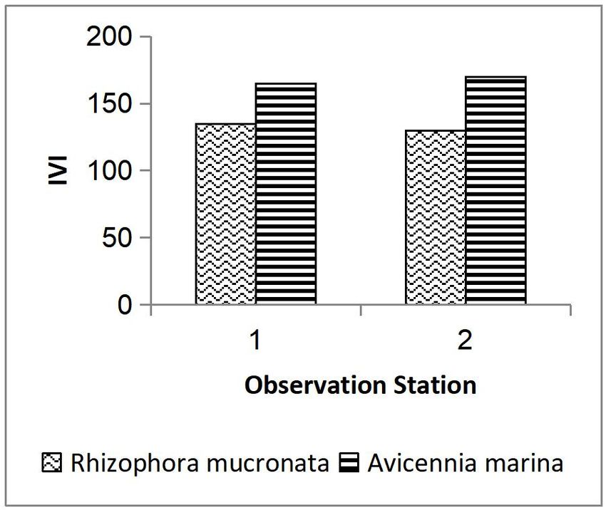
Assessment Of Coastal Environment Supports In Batam’S Pemping Island-Indonesia For
                                            Pipeline Gas Transmission
      28. Saenger, P. (1998). Mangrove vegetation: An                 in coastal plain region of the United States.
          evolutionary perspective. Marine and Freshwater             Agricultural Water Management, 186, 75-85.
          Research, 49(4), 277-286.
                                                                  31. Van Dorn, W. G. (1953). Wind stress on an
      29. Sarina, P.; Snoeyinkb, V. L.; Bebeeb, J.; Jimb, K.          artificial pond. Journal of Marine Research, 12,
          K.; Beckettb, M. A.; Krivena, W. M.; Clement, J. A.         249-275.
          (2003). Iron release from corroded iron pipes in
          drinking water distribution systems: Effect of          32. Wei, G. L.; Yang, Z. F.; Cui, B. S.; Li, B.; Chen,
          dissolved oxygen. Water Research, 89(5), 1259-              H.; Bai, J. H.; Dong, S. K. (2008). Impact of dam
          1269.                                                       construction on water quality and water self-
                                                                      purification capacity of the Lancang River, China.
      30. Sigua, G. C.; Stone, K. C.; Bauer, P. J.; Szogi, A.         Water Resource Management, 23, 1763–1780.
          A.; Shumaker, P. D. (2017). Impacts of irrigation
          scheduling on pore water nitrate and phosphate

896                                        Systematic Reviews in Pharmacy     Vol 11, Issue 12, December 2020
You can also read