Basilicata in Camper. This title has many meanings.
←
→
Page content transcription
If your browser does not render page correctly, please read the page content below
B       asilicata in Camper. This title has many meanings. The
fundamental motivation of this publication, patronized
by the regional agency for the promotion of the territory
(Agenzia di Promozione Territoriale della Regione) is to
contribute to the knowledge of a territory that in all its spots
lends itself to a tourism of discovery and comprehension
of habitats ready to welcome a motivated and interested
visitor. In Basilicata, every spot has its own identity, better
to say a soul that preserves the secrets of time, history,
country folklore and culture.In this scenario, people play
a special role with their warm hospitality and their desire
to let the visitors hear the voice of their land in the most
genuine form. Valuable principles that are revealed as a
painting giving the true image of a reality eager not to stu-
pefy but to introduce itself with genuine moderation and
spontaneous straightness.
   What kind of tourism can be proposed in this case? The
ideal choice is the one based on mobility, going to places
as to explore them, make each stop a source of the true
satisfaction that only a personal research can give. The ideal
implement for this voyage is the camper, no doubt: its phy-
siology is designed by the “abitar viaggiando” (at home
on the road) lifestyle. A new type of tourism, out of the custo-
mary patterns. The travelers are back, people who give a
new dimension to their relationship with the environment
by enriching it with the emotions of a vacation enlivened
by live places often unknown, in which life has precious
rythms, as in a musical background.
   This is Basilicata. The places described in this publication
are waiting for you and have a message for you, plenair tou-
rists: “We are here to welcome you! We are sure the answer
will be: thanks, we are coming”.
                                                 Raffaele Jannucci
                                        PleinAir • Editorial Director

                                               The parking areas indicated
                                               in the bochure have been
                                               identified within the project
                                               “Basilicata in Camper”
                                               of Regione Basilicata.

            Fondoeuropeodi svilupporegionale

                        UNIONE EUROPEA

            Investiamo sul nostro futuro

                                                                               Basilicata in Camper   I3
Nature and flavours

                            B      asilicata is one of the most varied regions of Italy. Its territory
                                   rises from the sea level up to 2.266 meters in Serra Dolcedor-
                            me, the highest peak of the Pollino mountain range. Up north, other
                            mountain peaks, from Mount Alpi to the wooded peaks surrounding
                            Potenza, complete the scenery of a rough and rocky land, yet colou-
                            red by the greenery of its wooded highlands. Among hundreds of
                            limestone peaks stands the unmisteakable shape of Mount Vulture,
                            an extinct vulcano flanked by the Pollino lakes and the sandstone
                            pinnacles of the Lucanian Dolomites.
                               The rocky landscape slopes down to the Thyrrenian coast and Mara-
                            tea, the well-known sea resort, and encircles the splendid Matera, whe-
                            re the Murgia plateau gives way to the chasm of the “gravine”, deep
                            canyons cut into the limestone. Another typical feature of the Basilicata
                            landscape are the gullies engraving the hills gently sloping down to the
                            beaches on the Ionian Sea. Carved by erosion, they surround tens of vil-
                            lages, contend with cultivated fields and woods, create lunar scenarios.
                               “There is no way to tell how many varieties of plants were offe-
                            red to our sight”, wrote in 1826 botanist Michele Tenore after a stre-
                            nuous trekking on Mount Pollino. Together with loricated pines, a
                            remnant of the last Ice Age, the massif is home to marvelous beech-
                            woods, Mediterranean bush and multi-coloured mountain flowers. On
                            the nearby mountains there are beech trees, oaks, holm-oaks, white
                            Laurenzana firs and some rare plants, such as the native Knautia Lucana.
                               In the rich and diversified fauna, the wolf, the deer, the vulture and,

4I   Basilicata in Camper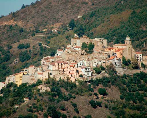
protected in the WWF oases of “Lago di San Giuliano” and “Pantano di
Pignola”, the stork, the crane, the white heron and the “Cavaliere d’Ita-
lia” (stilt bird). Eight centuries ago, Emperor Frederick II described the
great variety of prey birds in the area. The “grillaio”, the smallest hawk
in Italy, nests in the rocks around Matera.
    The natural beauties of Basilicata can be best enjoyed by living in
them. The mountain trails are id al places for birdwatching, moun-
tain biking, horse riding and climbing; by wearing snow shoes it is
easy to walk on the snow. On the Lucanian Dolomites iron steps can
be found and the very impressive “Volo dell’Angelo” (Angel’s Flight). On
the Thyrrenian and Ionian coast, sailing, kayak and snorkeling are usual-
ly practised.
    The variety of the territory is also reflected in the food and beve-
ra-ges: a century-old gastronomical tradition based on high-quality
wines (the Aglianico is the best known), olive oil, vegetables, pork
meat products, fish dishes, high quality cheese and other dairy pro-
ducts. And very tasty first courses of pasta, maccheroni, fusilli, strascinati,
recchietelle.
      Mouth-watering delicacies are: fried grapes, ”fusilli ubriachi” (drunk
fusilli), stuffed Ionian Sea anchovies, shrimps cooked with red onion,
Maratea-style vegetable soup, pork meat with apples and the “pastu-
rale”, a very tasty lamb stew. Traditional sweets are the “pezzotti”, sweet
wheat and other tasty tidbits. Gastronomical fairs are frequent, parti-
cularly during summer.

                                                                                  Basilicata in Camper   I5
I  talic warriors and Magna Graecia navigators, saints and emperors in
                               the Middle Ages, shepherds and brigands in nearer times, film direc-
                            tors and writers today, from Carlo Levi to Pier Paolo Pasolini and from
                            Francis Ford Coppola ( of Lucanian ancestry) to Mel Gibson. In the hi-
                            story of Basilicata many diverse important figures have left a footprint.
                            Among the remains of the ancient times excel the doric temples of Me-
                            taponto and the collections in the archeological museums containing
                            a large number of prehistorical artifacts discovered in the caves and on
                            the highlands.
                                Memory of the hard medieval times are the rock-nested hermita-
                            ges of the Matera Ravine (Gravina di Matera) or the fortified castles of
                            Frederick II in Lagopesole and Melfi and tens of historical centers wa-
                            tched over by castles and towers. In later times palaces of the nobility
                            and baroque-style churches were built; emigration and brigandage
                            have also left a distressing mark.
                                In this voyage of many miles through many centuries, little known ma-
                            sterpieces can be found: the Madonna con Bambino of the sanctuary in
                            Viggiano, the frescoes of the rock-nested churches in Matera and Melfi, the
                            medieval and Renaissance polyptychs of the churches in Genzano di Lu-
                            cania and Miglionico, the frescoes of the San Francesco church in Matera. In
                            the twentieth century, this land has been narrated by renowned painters as
                            Joseph Stella, Carlo Levi, Josè Ortega, and photographers as Mimmo Castel-
                            lano and Franco Fontana. Among the most famous films shot in the region,

6I   Basilicata in Camper
History and tradition

Vangelo secondo San Marco, Passione di Cristo, Ben Hur and the humorous
Basilicata coast to coast.
   A rough yet friendly land, Basilicata has welcomed with open arms the
Albanians (Arbereshe, living in the Pollino area) and the Waldenses, settled
in Nemoli a few centuries ago. In Pignola, Picerno, Tito and Vaglio Basilica-
ta gaul-italic dialects are spoken, similar to those of northern Italy. Each of
the 131 towns of Basilicata has its own calendar of religious and civil cele-
brations. Everywhere there are rituals celebrating the Virgin Mary and the
patron saints (Sant’Antonio Abate, San Rocco, San Giuseppe and San Vito are
the most venerated). Patron saints of Potenza and Matera are San Gerardo
and Sant’Eustachio. Folklore and tradition in the Carnival festival, splendid
celebrations for Christmas and the Holy Week (with Via Crucis and Corpus
Domini processions). On summertime, many events for fellow citizens co-
ming back home and tourists.
   Very old celebrations as Maggio (The Month of May) in Accettura,
“Volo dell’Angelo” (Angel’s Flight) in Pescopagano and the Christmas
and Saint Joseph bonfires arouse the interest of anthropologists and
people in search of folklore. Among the cultural events, special men-
tion deserve the film festival of Maratea and Pisticci, the fireworks on
the Basento river , the Etnofolk Festival of Satriano di Lucania and the
“La Luna e i Calanchi” (the Moon on the Gullies) of Aliano. All over the
year, a great number of exhibitions dedicated to local food products
and wines.

                                                                                  Basilicata in Camper   I7
1 Abriola

               Info
The parking area for campers is at
Pierfaone, at the feet of the ski runs.
GPS coordinates:
40.500827, 15.766259.

San Valentino, Abriola’s patron
saint, is celebrated on February
14 and August 14. Celebrations
to honour “Madonna Assunta”
on the first Sunday of June.
                                          S       outh of Potenza and the expressway to the Ionian coastline, thi-
                                                  ckly wooded high mountains rear up, frequented by the local
                                          people but little known to foreigners. Further of Pignola and the Sella-
                                          ta pass, the road slopes down to the medieval borough of Abriola, on
In July the uphill time trial             a hill at 957m. altitude. The settlement probably dates back to ancient
Abriola-Sellata.
                                          times, but the town as it is now was built by the Saracens, same as the
For information:                          nearby Pietrapertosa and Brienza. In later times, it was property of the
Municipal Office, ph. 0971 923230,        Orange, Di Sangro, Caracciolo and Federici families. In 1809, it was the
www.comune.abriola.pz.it.                 scene of the slaughtering of the Federici family by the brigands led by
Pro Loco, ph. 377 4777619,                Giovanni Rizzo, nicknamed Taccone. Memory of this crime is kept on
www.facebook.com/                         an inscription in the town’s castle; among the castel’s scarce remains,
Pro-Loco-Abriola.
                                          a portal surmounted by a crest.
                                             The Chiesa Madre di Santa Maria Maggiore, a church built in me-
                                          dieval times, has been renovated many times.Inside the church, the
                                          shrine of San Valentino Martire, the patron saint. On the 1998 bronze
                                          portal the Saint’s life and miracles are illustrated.
                                             A road goes down from the Sella pass to the sanctuary Madonna di
                                          Monteforte, originally an hermitage, renovated in the XVI Century and
                                          adorned with frescoes by Giovanni and Girolamo Todisco. Westward,
                                          the road up to the Sellata ski resort with lifting facilities and ski runs
                                          passing through the woods of Mount Pierfaone and Mount Arioso. On
                                          summer, the district offers very pleasant walking trips.

                                          8I   Basilicata in Camper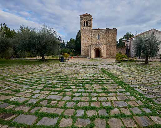
Accettura 2

                                                                                                Info
                                                                                 The parking area for campers is
                                                                                 at” località San Pietro”.
                                                                                 GPS coordinates:

T
                                                                                 40.484362, 16.159950.

                                                                                 Most important is the May Festival
         he first settlements in the Accettura territory date back to the ti-    of clear pagan origin, which takes
         mes of Magna Graecia, when it was called Acceptura. In early me-        place between Pentecost and the
dieval times a borough was built in the Raja area, where families coming         coming Tuesday. On January 16,
from Gallipoli, Costa di Raja and other places resettled.                        the bonfires for the celebrations in
    The town, under the name Achitorem, appears for the first time in a          honour of Sant’Antonio Abate
bull by Pope NiccolòII dated 1060. In the years around 1150 Accettura
                                                                                 For information: Municipal Office,
was subdued by Montescaglioso, in 1272 it was destroyed by a fire and             tel. 0835 675005,
rebuilt by order of king Charles I Anjou.                                        www.comune.accettura.pz.it.
    In later times until the XIX Century, Accettura was a fiefdom of the         Parco di Gallipoli Cognato,
nobility, the Bazzano, Della Marra, Ponsiaco, Carafa, Colonna and Spinel-        ph. 0835 675015,
li families. In 1861 gangs of brigands led by Carmine Crocco and Josè            www.parcogallipolicognato.it.
Borjès besieged the town; as Piedmont troops neared, the besiegers               Pro Loco, ph. 0835 675292 - 329
                                                                                 4042031, www.prolocoaccettura.it.
left the ground without engaging in a battle. .
    In the inner town, the churches “Chiesa dell’ Annunziata” in baroque
style, “Chiesa Madre di San Nicola” with its beautiful wooden statues,
“Chiesa di Santa Chiara di Gallipoli” , “Chiesa di Sant’Antonio”, and the cha-
pels of “Santi Giovanni e Paolo” and “Santa Maria dei Fiori” deserve a visit.
Noteworthy are too the stately mansions of the Amodio, Spagna and
Nota families of the nobility
    In the nearby areas, included in the “Parco delle Dolomiti Lucane e di
Gallipoli-Cognato”, the Spagna and De Luca fortified farms and the wood
of Montepiano are of some interest. In the Gallipoli-Cognato wood is lo-
cated the archaelogical area of Mount Croccia with remains of Italic walls.

                                                  Basilicata in Camper    I9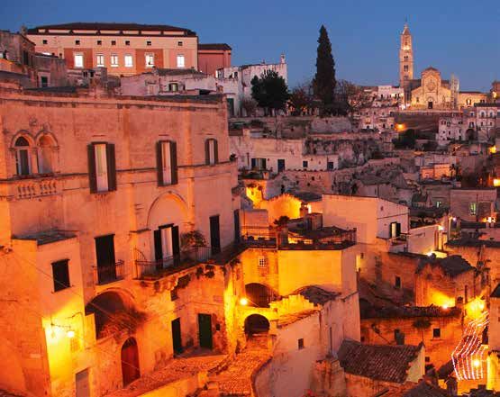
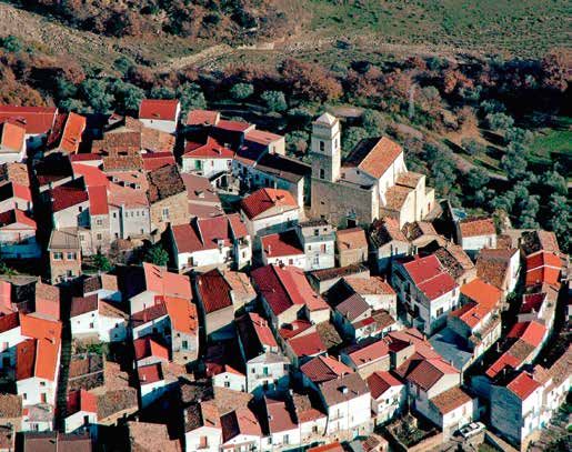
3 Albano di Lucania

               Info
The parking area for campers
is at Viale Padre Pio, at the

                                       A
border of the town.
GPS coordinates:
40.582007, 16.035363.
                                                 s a balcony facing the Basento valley and the rocky land-
The most attended religious events               scape of the Lucanian Dolomites in the background, Albano
are the two processions in honour    di Lucania preserves in its intact medieval structure a church of fasci-
of Madonna delle Grazie on the       nating beauty. At 900m. altitude, in the middle of the town, stands
third Sunday of May and July 1.      the impressive “Chiesa di Santa Maria Maggiore”, formerly dedicated to
On September 29, the celebration     “Madonna della Neve”.
of San Michele Arcangelo.
                                        Built on an early christian church, with a XVIII Century belltower at
For information: Municipal Office,   one side, the church has an austere three-nave Romanesque structure.
ph. 0971 984006, www.comune.            The huge neo-classical main portal on the front side of the church,-
albanodilucania.pz.it.               dated 1924, is very interesting and somewhat surprising. Inside, some
Pro Loco, www.proloco                medieval frescoes and a XVII Century statue of Madonna delle Grazie,
albanodilucania.it.                  most cherished by the local faithful.
                                        A latin inscription on the old Town Hall tells that the building was
                                     built with public money for public use in the year of Our Lord 1581.
                                     Dates back to the XVII Century the beautiful painting “Annunciazione”
                                     by Pietro Antonio Ferri, kept in Cappella dell’Annunziata in the Monte
                                     district.
                                        The Museo del Giocattolo Povero e del Gioco di strada. (Museum of the
                                     one-penny toy and street games) deserves a visit. The plateau behind
                                     the town , crossed by the roads to Campomaggiore and Tricarico, is an
                                     ideal place for walking and biking trips.

                                     10 I   Basilicata in Camper
Avigliano e Castel Lagopesole 4

                                                                                             Info
                                                                              The parking area for campers is at
                                                                              Castel Lagopesole, near Road 93.

E
                                                                              GPS coordinates:
                                                                              40.805949, 15.725102.
       mperor Frederick II, a great admirer of the mountains and woods        On June 14 and 15, the celebrations
       of Southern Italy, has linked his name to many castles of Basilica-    of San Vito, San Modesto and
ta. One with a most impressive and austere appearance, the castle in          Santa Crescenza. The “Madonna
Lagopesole (Castel Lagopesole), rises in the Avigliano territory, along the   del Carmine” celebrations take place
very ancient road connecting Potenza to Melfi, at the crossroad of the        at the beginning and end of May,
sheep tracks to Campania and Tavoliere delle Puglie (Apulia Plain).The        on the 2nd Sunday in September
                                                                              and on December 16.
castle, probably of Arabian origin, was enlarged in the period between
1242 and 1250 by will of Frederick II, who used it to get a rest during his   For information: Municipal Office,
game-hunting expeditions. Many times it was home to his son Man-              ph. 0971 701811,
fredi and his wife Elena of Epirus. It was also a summer residence of         www.comune.avigliano.pz.it.
the Anjou kings of Naples. In 1861 it was the bivouac of a gang of bri-       Pro Loco, ph. 0971 700888,
gands led by Carmine Crocco.The castle is one of the few in Southern          www.prolocoavigliano.it.
Italy with a church (and not a simple chapel) inside. It has been the
set of films, as Il Vangelo secondo Matteo (1964) directed by Pier Paolo
Pasolini. In a nearby district , the ethnographical museum dedicated
to the customs, traditions and trades typical of the area. In Avigliano,
The churches of “Santa Maria del Carmine”, “Santa Maria degli Angeli”
(with notable works of art inside), “San Vito”, “Santissima Annunziata” and
“Santa Maria de Cornu Bonu” (mentioned in a document dated 1164)
deserve a visit. Noteworthy are too the many stately mansions belon-
ging to the old nobility.

                                              Basilicata in Camper   I 11
5 Brindisi di Montagna

               Info
The parking area for campers is at
Via delle Fontanelle. GPS coordinates:
40.612233, 15.938623

On May 9 San Nicola, the patron
saint, and on August 15 the Virgin
Mary Assumption are celebrated.
At the end of October the Giornate
Medioevali (Medieval Times) take
                                         A         few kilometers from Potenza, a borough with an uncommon
                                                   name faces the Basento valley. Brindisi di Montagna , built at a
                                         860m. altitude in a position easily defendable against potential aggres-
                                         sors, lies in an area where human settlements date back to the Third
place. During Summer, the Parco          Millennium B.C.
della Grancia is the hub of shows           In the Archaelogical Museum in Potenza, proofs are found of hu-
and entertainments of many types.
                                         man presence from the prehistorical down to the Ancient Lucanian,
For information: Municipal Office,       Roman and Medieval times. Prior to the XI Century, a group of St Basil
ph. 0971 985002, www.comune.             monks founded the “Badia di Santa Maria dell’Acqua Calda” (Saint Mary
brindisi montagna.pz.it.                 of the Hot Water Abbey), donated in later times by the Sanseverinos to
Pro Loco, ph. 391 3923582,               the Cistercians of the monastery of Padula.
www.prolocobrindisi                         In 1268 Charles I Anjou entrusted the fiefdom of Brindisi and Anzi to
montagna.it.                             Guidone da Foresta, who built a castle to defend it, in later times en-
                                         larged by the following tenants. After the 1456 earthquakes, the town
                                         was rebuilt and populated by refugees coming from Albania, under
                                         the patronage of Pietrantonio IV Sanseverino, married to Irene, a niece
                                         of George Castriota Scanderbeg, the Albanian National hero.
                                            In 1799 Brindisi took part in the libertarian uprisings led by Father
                                         Fabrizio De Grazia. On November 2 in 1861, a thick fog saved the town
                                         from aggression by gangs of brigands led by Crocco, Borjes and Serra-
                                         valle. The churches dedicated to “ San Nicola di Bari”, ” Santa Maria delle
                                         Grazie”, “San Vincenzo Ferrari” and “San Lorenzo” (with the Grancia di San
                                         Demetrio on one side) deserve a visit.

                                         12 I   Basilicata in Camper
Calvello 6
Info
The two parking areas for campers
are located in Via Madonna del
T
Monte Saraceno; GPS coordinates
40.474121, 15.847550) and the
Cacciatizze district (GPS coordinates
he medieval hamlet of Calvello, surrounded by high, thickly 40.438871, 15.822524).
wooded mountains, can be reached from Abrida, Marsico
Vetere or Laurenzana through spectacular winding roads. Set at an al- On the second week of May, a
titude of 730 meters, it has been for centuries house of peasants and procession will carry the image
shepherds, as shown by the prominent sheep image in the town crest. of Madonna del Monte Saraceno
Calvello is also well known, in Basilicata and elsewhere, for the pro- to the dedicated shrine and on
duction of artistic pottery. September 8 and 9 the comeback
The first settlers were probably Lucanian people, the name Calvello, to town is celebrated. Noteworthy
deriving from the latin words caro (meat) and vellus (wool), testifies the are also the celebrations for the
Madonna della Pietà (first Sunday
presence of Rome in the territory. At the feet of the borough stands in June and third Sunday in
the white, impressive structure of the XV Century Chiesa Madre (Mother September) and the Festa
Church) which hosts important paintings as Giovanni Battista il Giovane dell’Emigrante (August 4).
(Young John the Baptist), l’Ultima Cena (the Last Supper), la Madonna
di Costantinopoli (the Virgin Mary of Constantinople), a work of the XVI For information: Municipality Office
Century florentine art school. ph. 0971 921911, www.
The church of Santa Maria del Piano (XII Century) has two portals of comune.calvello.pz.it.
Romanesque style, noteworthy frescoes, a XIX Century wooden Choir Pro Loco, ph. 331 702 1514, www.
and a beautiful cloister aside. Five frescoes by Girolamo Todisco in 1616 facebook.com/pg/Pro-loco-Calvello.
welcome the visitors of the Santa Maria degli Angeli church.
A graceful medieval bridge spans the Rio La Terra river. The “Centro
Energia e Territorio” houses a photographic exhibition dedicated to oil
prospecting.
The surrounding mountain peaks allow very pleasant outings, a
biking and walking track leads to Autiero.
Basilicata in Camper I 137 Campomaggiore
Info
The parking area for campers is in Via
Francesco Crispi. GPS coordinates:
40.566192, 16.073588.
On summertime, the open-air
show La città dell’Utopia tells the
story of Campomaggiore Vecchia.
For information: Municipal Office,
T he town of Campomaggiore, a perfect balcony on the Lucanian
Dolomites and the deep valley carved by the Basento river over
millennia, welcomes the visitors with a mostly modern residential area
and the Santa Maria del Carmelo parish church at its center. In the Parco
ph. 0971 982261,
www.comune. della Scultura, an itinerary which crosses the new and old sections of
campomaggiore.pz.it, the town,works of Lucanian and non-Lucanian artists (Miguel Ausili,Mi-
Lasequoia, La sequoia, chele Benedetto,Kho-Emon Hattori, Cesare Riva, Pasquale Martini) are
www.tiscali.it/lasequoia. exhibited. It is worthwhile a walking or biking trip to Campomaggiore
ProLoco, ph. 3333642872, Vecchia (4 km), the “ideal city” built by the Rendinas, the local feudal
www.prolocodicampo lords,designed in1741 by architect Giovanni Patturelli, a disciple of Van-
maggiore.it
(not yet available). vitelli.
Close to the church and the baronal palace, standing one in front
of the other in Piazza dei Voti, a block of semi-detached houses of mo-
dern look and comfort were built in the XIX Century.
To the families settled there land was donated to cultivate vineyards
and olive trees. In 1833 the residents amounted to 1500 people.
In 1885, a catastrophic landslide forced evacuation and abandon-
ment of the town. The surroundings of Campomaggiore, where many
wind farms have been installed, offer very interesting itineraries sui-
table for walking and mountain biking. The town also offers a selection
of sports centers.
14 I Basilicata in CamperCastelgrande 8
Info
The parking area for campers
is in Contrada Accolta.
GPS coordinates:
L
40.787858, 15.424775.
ocated in the most western corner of Basilicata, on the border In the calendar of religious
with Campania, the beautiful and quiet Castelgrande has been celebrations, most notable are the
one in honor of Our Lady (Madonna)
severely hit, as all the neighbour villages,by the earthquake in 1980.
on the last Saturday of April with
The town , the old Castrum Magnum (or Castrum Grandinis), probably bonfires, the one in honour of Santa
founded by the Normans, faces the Marmo valley. In the historical inner Maria di Costantinopoli (Tuesday
town, perched on a high ground, the Chiesa Madre (Mother Church) after Pentecost),the one in honour
stands out with its beautiful XVII Century wooden statues of the Virgin of San Vito, the patron saint
Mary and Saint Sebastian and a XVIII Century carved Choir. Noteworthy (July 5) and the one in honour
of Madonna dell’Assunta,
are also the San Giovanni gate and the nearby church of the same
the Assumption (August15 ).
name. Out of town, the Madonna di Costantinopoli church with other
notable artifacts. For information: Municipal Office,
The Parco dei Colori is the only botanic garden of Basilicata. Dedica- ph. 0976 4481, www.comune.
ted to the XIX Century scientist Guglielmo Gasparrini, it covers nearly castelgrande.pz.it.
two hectares where hundreds of native plants grow. The garden has Associazione Basilicata Sport
Adventure, ph. 320 6062354,
the shape of a leaf with the Casa delle Farfalle (Butterfly House) at its
www.basilicatasportadventure.com
center, where tropical vegetation and hundreds of rare butterflies are Pro Loco, ph. 345 3708073.
on show.
On the Toppo Mount is located the Osservatorio Astronomico di
Castelgrande, seat of SINGAO (Southern Italy Neutrino and Gamma
Observatory), a 160cm diameter optical telescope controlled by the
Osservatorio Astronomico di Capodimonte (Naples). The Castelgrande
territory offers walking excursions, water stream sports and climbing.
Basilicata in Camper I 159 Cirigliano
Info
The parking area for campers
is in località Acqua Furr.
GPS coordinates:
O
40.446202, 16.137490.
Very interesting the Carnevale di ne of tiniest towns of Basilicata, Cirigliano is located on the
Cirigliano, with people parading in hills of the Sauro Valley, near Road 92 linking the Ionian co-
the streets, Sunday to Mardi Gras. ast to Laurenzana and Potenza. The place is also known for its pits of
The patron saint San Giacomo is Cirigliano stone, a sandstone used for floors,coverings and restorations.
celebrated on July25. Human settlements in this area date back to very ancient times, the
For information: Municipal Office, name Cirigliano is probably linked to Cerellius, a Roman centurion who,
ph. 0835 563081 at the end of his military duty, retired in these hills. The first document
www.comune. where mention is made of the town is a bull of the diocese of Tricari-
cirigliano.mt.it. co dated 1060. Surrounded by walls and towers, the residential area is
Pro Loco, ph. 360 438069 protected by a feudal castle with a tower of typical oval shape. Bought
www.prolococirigliano.mt.it. in 1595 by the Coppola family, the castle in XVIII Century became pro-
perty of the Formica baronal family, still the owner. The inside chapel
dedicated to “Madonna Addolorata” preserves a XVII Century “Pietà”.
Paintings and frescoes of good quality are also found in the Chie-
sa Madre, unfortunately a wooden statue of Beato Angelico Seno was
lost. Between the church and the castle lies the small but suggestive
historical section of the town with its strette (narrow streets) and typical
buildings.The most important is Palazzo Fanelli, where the Vicarage and
a boarding house for old people are located. The chapel of Santa Lucia
and the floor of the square are made of Cirigliano stone. Out of town ,
the little church of Madonna della Grotta, carved in a huge stone: accor-
ding to a local legend,it was made by a repentant bandit.
16 I Basilicata in CamperFiliano 10
Info
The parking area for campers
is in Via Campo Sportivo.
GPS coordinates:
O
40.811466, 15.708814
n the hills between Potenza and Melfi, with a view of the im- Among the folklore events
posing outline of Mount Vulture, the extinct volcano of Basi- special mention deserve:
licata, Filiano retains one of the oldest and most surprising artifacts of Lu Muzz’c (the bite), La Giornata
Italy.In 1966, in some caves on the ” Tuppo dei Sassi” ( the Stony Hill), del Mietitore (the harvester’s day)
some red ochre paintings of the Mesolitic period were found, showing in August, the Sagra del pecorino
(Fair of the local sheep-milk
a hunt with men, deers and goats. cheese)in the first days
Filiano, at the crosspoint of old roads as Via Erculea, a branch of Ap- of September. The most
pia Antica, is located at the center of an extraordinary and fascinating spectacular and renowned
territory. Only a few miles away from the town, the Riserva Agromonte religious celebration is the
Spacciaboschi protects the ruins of Acermontis, a medieval village whe- Via Crucis (Way of the Cross),
re a church, a fortress and walls can be identified. a procession along the town’s
streets on Good Friday’s evening.
The name of the town is a reminder of wool spinning, an important
activity in an area where sheep-herding was and still is a fundamental For informationi: Municipal Office,
asset. The sheep tracks of Toppa, Spina-Serra Cocozza, Inforchia and Ripa ph. 0971 836010,
Rossa are very interesting to walk. The “pecorino” a sheep milk cheese www.comune.filiano.pz.it.
made in Filiano is one of the most prized products of Basilicata. The Pro Loco, ph. 0971 1895337,
most beautiful church in town is Santa Maria del Rosario, built in 1830, www.prolocofiliano.it
a one-nave architecture with a graceful marble altar. Not far, the chur-
ch dedicated to Saint Joseph . Unpretentious but suggestive are two
small churches dedicated to Saint Anthony in the Sterpeto and Scalera
districts. Noteworthy is Palazzo Corbo, an historical country mansion at
Iscalunga.
Basilicata in Camper I 17Info
Matera offers three parking areas
for campers, located at Jazz Gattini,
Masseria Radogna (GPS coordinates:
45.1851, 18.4629), Via dei Normanni
S
in Parco Serra Venerdì (GPS coordinates:
40.66814, 16.5896) and Tenuta
Lamacchia on the Appian Way
(GPS coordinates: 40.3751, 16.357). ixty years is the time interval between Cristo si è fermato a Eboli,
the book written by Carlo Levi to tell the poverty conditions of
The Madonna della Bruna patron Southern Italy and La Passione di Cristo, the first film directed by Mel
saint celebration takes place on July Gibson, which has used the Sassi scenario as an extraordinary film set.
2 since 1389; among other events, These were the years of a radical transformation of the town.
a papier-machè triumphal cart is The poor and derelict Matera of the past has become one of the
destroyed.At Christmas time, Sassi
hosts the biggest live Nativity most fascinating destinations in Europe. An image corroborated in
Scene in the world. On August 1, 1993 by the inclusion of the Sassi in the UNESCO list of World Heritage
the Capriata Festival, a kind of Sites and the subsequent nomination of Matera as European Capital of
Thanksgiving Day with ”capriata”, the Culture for 2019. No other place in the world allows visitors to be
a tasty soup of legumes and immersed in a magic atmosphere of prehistorical events and medieval
cereals.In the past the celebration religiousness.
was staged in the Sassi area,
now in the Martella suburb. The “Gravina di Matera”( Matera’s Ravine), in front of the town, is the
first system of canyons extending to Gravina di Puglia, Laterza and Ta-
For information: Municipal Office, ranto. All around the town and the ravine, the Murgia plateau. A visit to
ph. 0835 2411, www.comunema the Ridola Museum will help to discover the footsteps left by people
tera.it. Ufficio Informazione living in the ravine from the prehistoric times to the Iron Age.
e Accoglienza Turistica (Information Of minor importance during the centuries of the Pax romana, Matera
and Tourism Office), ph. 0835 311655.
APT della Basilicata, regains prestige in the early medieval times, when the Murgia is a matter
ph. 0835 331983, of conflict between Byzantines, Franks, Longobards, and Saracens.
www.aptbasilicata.it. The ravines become shelter for monks coming from Cappadocia
Pro Loco Sassi di Matera, and Armenia and for the faithfuls to the Roman Church.
ph. 335 5346892,
www.prolocosassidimatera.it.
18 I Basilicata in CamperMatera 11
Many man-made caves are used as homes and are occupied by
people living in dignified poverty. The degradation told by Carlo Levi
is created after the unification of Italy, when the clashes between Pied-
montese army and the brigands cause depopulation in the country
and an increase of the urban population.The reclamation of the Sas-
si area was object of discussions in the post-war years, but it started
only after the 1980 earthquake. Today, the visitors go from the modern
town down to heart of the Caveoso and Barisano ,separated by the Ci-
vita rocky ridge where the cathedral rears up. Step after step, churches
and chapels carved in the rock are discovered as San Nicola dei Greci,
Madonna delle Virtù, San Pietro e Paolo, San Giorgio al Paradiso, Santa
Barbara and Santa Maria de Idris, leading to the crypt of San Giovanni
in Monterone.
Some reclaimed Sassi have been converted into museums or exhi-
bitions and collections of artistic works. The Caveoso area is dedicated
to the MUSMA sculpture museum (Museo della Scultura Contempora-
nea di Matera). In the upper town, many other churches and a castle
not yet completed welcome the visitors. Walking through Murgia Timo-
ne, a prehistoric village, small churches and rock-carved hermitages are
encountered; the entire area is protected in a regional park.
Basilicata in Camper I 1912 Lavello
Info
The parking area for campers
is at Via Aldo Moro.
GPS coordinates:
I
41.043853, 15.781087.
Of great interest the Carnevale n the northernmost corner of Basilicata, the historical and graceful
Lavellese (Lavello Carnival)
and the Mietitura e Trebbiatura
town of Lavello stands halfway between the Tavoliere delle Puglie
(Harvesting and Threshing) (Apulia’s Plain) and Mount Vulture. The name, originating from the Me-
Festival in July. The most dieval Latin word labellum (sheep watering hole), indicates the position
important religious celebrations of the town along the sheep tracks of the seasonal migrations.
are those of the Settimana Lavello was an important stronghold of Byzantines and Longobards;
Santa (Holy Week), the two in the year 839 it was the scene of the assassination of Riccardo, duke
celebrations of San Mauro,
the patron saint, on May 2
of Benevento. Since 1025 it is Episcopal See, under the Norman rule it
and November 22 and the was one of the twelve baronies of the County of Apulia. Frederick II of
pilgrimage to the Santuario Suebia enlarged the fortress built by the Longobards, where his son
dell’Incoronata in Foggia. Corrado IV died in the year 1254. In the year 1298 Lavello was set to fire
by order of Charles I Anjou, an event remembered in the town’s crest.
For information: Municipal Office In later times, the town was property of the nobility: Orsini del Balzo,
ph. 0972 80111, www.comune.
lavello.pz.it.
Del Tufo, Pignatelli and Caracciolo di Torella.
Pro Loco ph. 339 4846644, The castle, renovated in the XVIII Century, houses the Town Hall and
www.prolocolavello.com. an Antiquarium. The most important churches are Sant’Anna (with a
XVI Century Annunciazione by Antonio and Costantino Stabile), Santa
Maria ad Martyres and Santa Maria delle Rose.
The Mostra della Civiltà Contadina deserves a visit. Out of town, the
XIX Century Masseria Marchesa with huge towers at its corners, and
Casa del Diavolo (the Devil’s House), the ruins of a Roman spa.
20 I Basilicata in CamperMarsicovetere 13
Info
The parking area for campers is
in Villa d’Agri, via Berlinguer;
GPS coordinates:
T
40.348180, 15.817364.
he medieval heart of Marsicovetere is an extraordinary view- San Bernardino da Siena, patron
saint of Marsicovetere, is celebrated
point. Protected by Monte Volturino, which reaches the height
on May 20.The image of Madonna
of 1,836 meters, it faces the wide Agri valley and the Cervati and Sirino Assunta (Virgin Mary Assumption)
mountains behind. Marsicovetere, situated at 1,000 m. altitude, has ita- is carried to the sanctuary on the
lic origins and can be identified with the fortress indicated by Strabo- last Sunday of May and is brought
ne with the name of Vertina. The location was re-populated in early back in town on August 15. During
medieval times after the Roman town of Grumentum was devastated August there is a very important
by the Saracen raids. The return to the lands down the valley started exhibition dedicated to Lucanian
at the beginning of the XIX Century, when the Villa d’Agri settlement wines and truffles.
was built.
For informationi: Municipal Office,
The imposing ancient castle perched on the edge of a rocky cliff has
ph. 0975 69033, www.comune.
given way to a hamlet which preserves parts of the walls and the main marsicovetere.pz.it.
gate. The Chiesa Madre (Mother Church) dedicated to St Peter and St Pro Loco di Villa d’Agri,
Paul, located in the upper town, was completed in 1639: it is a conspi- ph. 347 5765009 - 338 4583505,
cuous example of neapolitan baroque and it has been repaired after www.prolocovilladagri.it.
the earthquakes of 1857 and 1980.
In the nearby Barricelle district, the ruins of a Roman country resi-
dence, center of archeological excavations in 2006. To promote excur-
sions, Mount Volturino has been fitted on the northern side with lifting
facilities.Near the summit, the sanctuary of Santa Maria Assunta.
Basilicata in Camper I 2114 Moliterno
Info
The parking area for campers
is in the Parco del Seggio site.
GPS coordinates: 40.244115, 15.65827.
M
The most important celebrations
are dedicated to Madonna del oliterno, standing at south in front of Val d’Agri and Pietra del
Carmine (Our Lady Of Mount Pertusillo basin, offers to the visitors one of the most impor-
Carmel)on July 15 ,16 and
San Domenico, the patron saint
tant historical centers of the Parco Nazionale dell’Appennino Lucano. It
(August 4 ). In the Summer period, can be easily reached through the expressway running down the val-
there is also a festival on the ley or the A3 Highway (exit Buonabitacolo-Padula).
Canestrato, a very tasty soft cheese. The town is guarded by an imposing castle restored after the 1980
earthquake. The churches “Chiesa Madre dell’Assunta”, “della Trinità,” “del
For information: Municipal Office, Rosario”, “San Francesco di Paola” and “Santa Croce” deserve a visit. In San-
ph. 0975 668511, www.comune.
moliterno.pz.it..
ta Croce a precious painting is preserved, the “Deposizione” by Giovanni
Pro Loco, ph. 320 4090442, Di Gregorio, named “il Pietrafesa”, a XVII Century painter born in what is
www.prolococampusmoliterno.it. now Satriano di Lucania.
The museum-home of Domenico Aiello, containing a library and a
collection of stamps and paintings of noteworthy Lucanian painters,
gives a very real image of the life in the villages of Basilicata in the old
times.
Downhill, near the lake, the ruins of Grumentum, a Roman settlement
of the III Century B.C., destroyed by the Saracen raids in the XI Century.
In the ruins, surrounded by century-old oak trees, an amphitheatre and
the basements of some temples can be identified; a small archeologi-
cal museum is also open to the visitors.
22 I Basilicata in CamperMontalbano Jonico 15
Info
The parking area for campers
is at Vaccariccio, located at the
outskirts of the town
A
GPS coordinates:
40.293277, 16.657040.
few kilometers from the Calabrian border, with a view on the
the Ionian coastline and the easternmost peaks of Mount Pol- San Maurizio, the patron saint,is
lino, this ancient and densely populated town is renowned for the li- celebrated on September22. At
corice, harvested in the nearby gorges, and the impressive gullies sur- the of May, the Sagra dell’Arancia.
rounding the site. To protect them, in 2011 the Riserva Naturale Regio-
For information: Municipal Office,
nale was created, with center in Tempa Petrolla, a geological site visible ph. 0835 593811, www.comune.
from the north-east viewpoint of the town. montalbano.mt.it.
The origins of Montalbano Jonico probably date back to the times Riserva Naturale Regionale,
of Magna Graecia Among the monuments built in later times the most ph. 327 7638797 - 339 4082761,
important is the “Chiesa Madre di Santa Maria dell’Episcopio”, with a XII www.ceaicalanchi.com.
Century wooden statue of Madonna con Bambino (Virgin Mary with Pro Loco, ph. 0835 594066.
Child). Two square towers are the remains of the mighty Norman walls
protecting the town. The oldest district, Terravecchia, goes back to the
times of Frederick II. The mainstreet Corso Carlo Alberto is lined with the
mansions of the nobility or affluent citizens, built between the XVI and
XX Centuries. It is probably of medieval origins the Torre dell’Orologio,
the Clock Tower, heavily reworked in more recent times.
The trails of the regional reserve (run by Legambiente, a national agency)
lead to Petrolla and the remnants of an old castle. Very interesting are
also the pathways going from the town down to the Metaponto sheep
track, used for the seasonal migrations up to the beginning of the XX
Century.
Basilicata in Camper I 2316 Nemoli e Lago Sirino
Info
The parking area for campers
is near Lake Sirino, in Via Domenico
S
Di Lascio. GPS coordinates:
40.092875, 15.805969.
The Sagra della Polenta festival ituated between the mountains and the Thyrrenian sea at short
at Carnival time, attracts a lot of distance from Highway A1 (Autostrada del Sole), Nemoli offers a
people. More restrained but very pleasant starting point for the exploration of Thyrrenian Basilicata, from the
fascinating is the atmosphere Maratea coastline to the ridges of Mount Sirino.
around the Falò di Natale The first settlements in this area date back to the V Century B.C., as con-
(Christmas Bonfire) on the evening firmed by little statues of warriors and animals found near a votive offer. In
of Christmas Eve. In August,
a pilgrimage to the shrine medieval times Nemoli, named Bosco at that time, belonged to Lauria and
of Madonna del Sirino. was at later times merged with the Rivello territory.
In the middle of the XVII Century, Nemoli gave shelter to a group of
For information: Municipal Office Waldensians refugees expelled from Piedmont, coming from the nearby
ph. 0973 40001, Calabria. It was declared an independent municipality by the Repubblica
www.comune.nemoli.pz.it. Partenopea in 1799. The Strada delle Calabrie (Calabrian Way) built in 1806
Pro Loco, ph. 348 4625503,
www.facebook.com/pg/ contributed to improve the living conditions and increase the population
ProLoco-Nemoli. of the area, where mills and workshops of iron and copper products were
established.
In the inner town , characterized by narrow streets and porticoes, some
ornate portals and the arcade, in Neapolitan style, of the XVIII Century Pa-
lazzo Filizzola can be admired. The church dedicated to Santa Maria delle
Grazie(XVII Century) keeps a XIV Century multicolored Madonna statue of
Byzantine style, a font and a very ornate rose window. At short distance
from the town, Lake Sirino, an oasis of coolness, which can be reached
from the Lagonegro and Lauria exits of Highway A3. In a nearby church, a
rose window of Neapolitan style, a wooden Christ of the Ortisei craftmen
and a wooden Holy Family can be admired.
24 I Basilicata in CamperNova Siri 17
accorciare 4 righe
(cut 4 lines)
W
Info
elcome to Magna Graecia! Nova Siri, on the border between Ba- The parking areas for campers is at
silicata and Calabria, is a name that reminds the ancient Siris, Lido, Piazzetta Otto e Mezzo. GPS
founded by Greek settlers at themouth of the Sinni river. At the end of the VI coordinates: 40.127859, 16.654013.
Century, a decline of the town and subjection to Metaponto and Crotone.
In early medieval times, as protection against the raids of the Saracen On August 21 the most important
religious celebration near the little
pirates, a new town was built, approximately ten kilometers from the Io- church Madonna della Sulla. Many
nian Sea coastline.The name Siritide of the original territory is a reminder various events dedicated to wine
of the ancient town. tasting, as “Bevi e Vivi” (Drink and
Today, many visitors come to Nova Siri during summer to enjoy its very Live) in July and “La notte di Aprilla”
beautiful beach. It is however worthwhile all over the year to go up to the (The Night of Aprilla) in December.
355 m. altitude of the town, enjoying the beauty of panoramic roads, in a
For information: Municipal Office,
scenario of cultivated fields and olive groves. ph. 0835 5061,
In the inner town, which still preserves the medieval structure, stands www.comune.novasiri.mt.it.
out the “Chiesa Madre di Santa Maria Assunta”. A simple architecture outsi- Pro Loco, ph. 347 8879252,
de, a marble main altar (1730) and a beautiful wooden Choir (1735) inside. www.proloconovasiri.it
The belltower was rebuilt in 1866.
The castle, built at the end of the XIV Century, was property of several feu-
dal lords, from Spanish nobleman Castro Sandoval to Duke Francesco CriveIli,
the last owner. At a lower level, there is Palazzo Settembrini, named after the
family of the Italian writer and patriot Luigi Settembrini(1813-1877).
At “Marina di Nova Siri”, the soaring Torre Bollita (Boiled Tower) also known
as “Torre di Ferro” (Iron Tower), built in 1520 for protection against raiders.
Halfway between the coastline and the town, remains of the Roman
Age, including a villa and its spa facilities.
Of Roman origins too are the “Vasche di Sant’Alessio” (Saint Alexis Po-
ols), source of a crystal water believed to be a body purifier. At a short
distance below the town, the XVII Century church “Madonna della Sulla”,
well known for a religious celebration which takes place in August.
Basilicata in Camper I 2518 Policoro
Info
The parking area for campers is
at the crossroad of Via del Lido
and Via Aristarco, a few hundred
B
meters from the beach.
GPS coordinates:
40.187910, 16.713510 eaches, archeology, local products, nature. These are the at-
tractions of Policoro, the heart of the Ionian coast of Basilicata.
During summer Policoro hosts The modern town, born in the post-war period of World War 2 in the
reviews as Blues in Town, Policoro middle of a very fertile territory (where strawberries, oranges, grapes,
in Swing and a Balloon-Festival of kiwi, tomatoes and other delicacies are grown), is watched over by the
the comic strips and children’s XIV Century baronal castle. The little church of “Madonna del Ponte.”
literature. In May, the Festa della
(Our Lady of the Bridge) too dates back to the Middle Ages.
Fragola and the celebration
The vast archeological area and the “Museo Nazionale della Sirtide”
of the “Madonna del Ponte”.
tell us the history of the ancient Herakleia, a town in Magna Graecia
For informationi: Municipal founded in the V Century B.C. and where, some 150 years later, the
Office, ph. 0835 901911 Roman legions were defeated by Pyrrhus, king of Epirus and nearby
www.policoro.gov.it. Taranto. Of this period too are the Tables of Heraclea, kept in the “Museo
Museo Archeologico della Archeologico” in Naples, where some texts in Greek language on the
Siritide, ph. 0835 972154. laws governing the town are cast in bronze.
Pro Loco, ph. 348 5410008, Even though the agriculture requires work and care all the year
prolocopolicoro@libero.it. round, on summertime the hub of the Policoro economy and social
life moves into the beaches of the Ionian Sea. Near the coastline, west
of Lido, a regional natural reserve run by the WWF protects the “Bosco
di Policoro” (Policoro Wood), named “ the verdant labyrinth” by Norman
Douglas a century ago.
The area is home to a most interesting flora and fauna and allows
activities of the type most liked by young people: sailing, snorkeling ,
walking. In the Ionian waters the monk seal has recently re-appeared.
26 I Basilicata in CamperRapone 19
Info
accorciare 3 righe The parking area for
(cut 3 lines) campers is at Via Ferrara.
GPS coordinate:
A
40.850263, 15.492057.
The Carnival Feast and the religious
few years ago it has become the “Village of the Fairy Tales”. Yet celebrations of the Holy Week are
Rapone, a viewpoint on the valley of the Ofanto river and the interesting events. On May 8, the
sheep tracks linking the Salerno plain to the “Tavoliere” (Apulia plain) , Virgin Mary is worshipped in the
has a long history behind. It stands at an altitude of 838 m. among softly church of Santa Maria dei Santi,
sloping hills, where agriculture and sheep rearing are the prevailing acti- on September 29 the celebration
of San Michele Arcangelol. San
vities. The human presence on these hills dates back to Neolitic times.
Vito Martire, the patron saint,
Rapone was founded by the inhabitants of another town on the moun- is celebrated on June 15,
tainous right side of the Ofanto river, fleeing their homes to escape the accompanied by the “Volo
Byzantine-Gothic wars of the VI Century. dell’Angelo” (Angel’s Flight). On July
The new settlement appears on maps and documents after the XI 16 the Madonna del Carmelo is
Century. Under the Norman domination, until 1169, is part of the Contea celebrated. The events related to
the fairy tales take place in October.
di Conza, in later years it is one of the boroughs that repaired the San Fele
castle, as ordered by Frederick II. For information: Municipal Office,
In 1271 Charles I Anjou grants the town to Hervé de Chevreuse, Fren- ph. 0976 96100
ch, the first of a long sequence of feudal lords ending with the Sanseveri- www.comune.rapone.pz.it.
nos, the Carafas and the D’Annas. In the first decades of the XIX Century, Pro Loco, prolocorapone@libero.it
Rapone has a role in the battles of the Italian Risorgimento. In 1980 it is
hit by the earthquake that caused heavy destructions in the near Irpinia.
Noteworthy is the San Nicola di Bari parish church(XVI Century), restored
after the earthquake, preserving valuable artistic works. The oldest church
in town is “Santa Maria dei Santi” , built in 1131 by San Guglielmo da Vercelli.
A visit deserve also the church of “Santa Maria ad Nives” with a portal
built in 1815 and the chapels of “Calvario , Sacro Cuore, San Michele Arcan-
gelo and San Vito Martire. In the last years, the project “Rapone, Paese delle
Fiabe” (Rapone, the Village of the Fairy Tales) has enriched the borough
with special events and modern sculptures.
Basilicata in Camper 27I20 Rotondella
Info
The parking area for campers is at
Via Antonio Gramsci. GPS coordina-
tes GPS : 40.170301, 16.521767.
M
The list of events includes
the religious celebrations of
Sant’Antonio Abate (January 17) any boroughs in Basilicata are located in spectacular posi-
and Sant’Antonio da Padova, tions and with their plan and structure remind us of their ori-
the patron saint of Rotondella gin in the antiquity or medieval times. Few of them, however, have the
(May 17), the Sagra delle albicocche perfect architecture of Rotondella, the “Balcony on the Ionian Sea”, stan-
(Festival of the Apricots), end ding up on a hill at a 10km distance from the Ionian sea beaches, with
of June/early July and the
a westward view of the Pollino mountain range. The town, “Rotunda
Estate rotondellese (Rotondella on
summertime), July 20 to August 20. Maris” according to medieval documents, ‘a Rëtunnë in the local dialect,
stands at a 575m. altitude, looking over a landscape of cultivated fields,
For information: Municipal Office, olive groves and gullies. Up on the highest point, the “Torre del Carcere”
ph. 0835 844111, (Jail Tower), built in 1518 by prince Ferrante Sanseverino, surrounded
www.comune.rotondella.mt.it. by the baronal palace. Noteworthy are also the Tucci-Cospito, Ielpo,
Pro Loco www.facebook.com/
Rondinelli (in XVIII Century baroque style) and Albisinni mansions.
Pro-Loco-Rotondella.
The graceful ”Chiesa Madre”, dedicated to Santa Maria delle Grazie,
preserves precious little wooden statues of the “Immacolata” (Immacu-
late Conception), “Madonna delle Grazie” and “Sant’Antonio di Padova”.
This latter belonged to the Franciscan monastery of the Zoccolanti
(clog wearers). Noteworthy too are a multi coloured marble altar and
other statues of saints.
Mount Coppolo, standing over the ravine at the merging point of
the Sarmento and Sinni rivers, is still surrounded by the walls of a for-
tified town dated by the archaeologists to the IV Century B.C. It is pro-
bably the town of Lagaria, founded the mythical Epeus, the builder of
the wooden horse that allowed the Achaeans to conquer Troy.
28 I Basilicata in CamperSalandra 21
Info
The parking area for campers is
located at Serre, a few kilometers
from the town center.
S
GPS coordinates:
40.547312, 16.314113.
urrounded by the hills south of the Basento Valley, Salandra
On August 16, San Rocco, the
stands up on an isolated plateau carved by spectacular gullies. patron saint, is celebrated.
As many other boroughs of the area, despite its modest altitude (600m.
a.s.l.), Salandra, with its stairways and steepy alleys, has the features For information: Municipal Office,
of a mountain village. ph. 0835 673778,
Even though settlements in this area date back to the pre-historical www.comune.salandra.mt.it.
times , the town as it looks now has the medieval structure of the times Pro Loco di Salandra, ph. 0835
of the Norman rule. In 1861 the town repelled with a bloody battle the 673802, www.prolocosalandra.it.
attack by a gang of brigands led by Carmine Crocco .
At the entrance of the historical inner town, the visitors will find a
square with the San Biagio church, made of terracotta; on the other
side, the huge structure of the Sant’Antonio church (with a XVIII Century
portal and a magnificent organ dated 1570) and, at short distance, the
Franciscan monastery, now the Town Hall.
At the center of the cloister, surrounded by the municipal facilities,
a graceful XVI Century well with columns aside; it certainly deserves a
visit (as a bonus, it is an oasis of coolness even in the hottest hours of
a summer day).
The visit to the inner town has no planned routes through the stair-
ways and the narrow streets. Noteworthy are the “Porta Nuova” (New
Gate) and the “Chiesa Madre della Santissima Trinità” (Mother Church of
the Holy Trinity) of medieval origin, restored after the 1857 earthquake.
Basilicata in Camper I 2922 San Mauro Forte
Info
The parking area is at Via Don Biagio
Spaziante (in the Cretaccio district)
at the town’s entrance for those
O
coming from Salandra or Craco.
GPS coordinates:
40.484133, 16.254014. ne of the most beautiful medieval architectures of Basilicata
welcomes the visitors of San Mauro Forte, a surprisinglyh iso-
Interesting events are: the “Sagra
del Campanaccio” (Festival of lated on the highlands south of the Salandrella torrent, slightly east of
the Cow-Bell), January 16 and the “Parco Nazionale di Gallipoli Cognato” and the Lucanian Dolomites; a
on, linked to the worship of territory with settlements dating back to prehistoric times. The visitors’
Sant’Antonio Abate and the attention is drawn above all by the “Torre Normanna” (Norman Tower),
Procession of Good Friday home of a small but interesting museum, built in the XIII Century on
which starts from the Franciscan
the top of the hill on which the town lies, near the “Chiesa Madre di
monastery and stops in all
the town’s churches Santa Maria Assunta church. The square around the church is the hub
of the town’s social life and a magnificent viewpoint that on the east
For informationi: Municipal Office, side extends down to the Ionian Sea. .
ph. 0835 674015, Facing the square, the stately Palazzo Arcieri Bitonti with its Museo Multi-
www.comune.sanmauro mediale “in viaggio in Basilicata” (touring Basilicata).
forte.mt.it.
Equally suggestive is the nearby Palazzo Lauria, with a graceful ba-
Pro Loco, facebook.com/
prolocosanmauroforte roque-style XVIII Century portal and a private chapel. Among the anti-
ques kept inside, two Venetian –style jewel caskets dated XVII Century.
In Palazzo Arcieri, formerly Town Hall and Magistrate’s Court, the “Museo
della Civiltà Contadina” (Museum of the Rural Civilization) is hosted.
30 I Basilicata in CamperSasso di Castalda 23
Info
The parking area for campers is at Via
Campo Sportivo. GPS coordinates:
40.483638, 15.674726.
A midst the heights separating Potenza and the Val d’Agri, at a
959 m. altitude, lies one of the most surprising little towns of
Basilicata, Sasso di Castalda, the ancient Saxum, a simple yet charming
historical site surrounded by partly barren and partly wooded hills.
San Rocco, the patron saint, is
celebrated on May 16 and August
16.The August celebration starts
with a procession and ends with
a gala of fireworks.In early August,
the lively Palio di Sasso, a traditional
Facing the Sasso’s main square, stands the “Chiesa Madre dell’Imma- horse race. On September 14,
colata” , dedicated to the Immaculate Conception, with a graceful por- the processions dedicated to
tal. Inside, a XIV Century statue of “Madonna con Bambino” (Virgin Mary “Santissimo Crocifisso” and
with Child), XV Century paintings, a confessional with carvings dated “Madonna Addolorata”.
to the Renaissance times and XVII Century frescoes. Less ornate are the
churches of San Rocco and Sant’Antonio. Some remnants are left of the For information: Municipal Office,
Gaetani d’Aragona castle. ph. 0975 385016,
Street names and inscriptions keep the memory of notable Sasso www.comune.sassodi
citizens as Rocco Beneventano, a XIX Century jurist, Giuseppe De Luca, castalda.pz.it.
Pro Loco Il Nibbio, ph. 0975 203634,
editor, Mariele Ventre, a musician promoter and leader of the children www.prolocoilnibbio.blogspot.it
chorus “Piccolo Coro dell’Antoniano” and Rocco Petrone, director of the
Apollo Program and NASA Marshall Flight Center.
Sasso di Castalda, in these last years, has given increasing attention
to open air activities. This interest is reflected in the construction of the
trail climbing up to the panoramic viewpoint, the two Tibetan bridges
spanning a ravine and the creation of the Cervo faunal area. Close to
this area is the starting point of “Sentiero Frassati” (Frassati Trail), which
passes by the “Mulino del Conte” (The Count’s Mill) and the legendary
“Faggio di San Michele” (Saint Michael BeechTree). Lifting facilities are
available on Mount Pierfaone.
Basilicata in Camper I 31You can also read