CADASTRE 2014 and Beyond - FIG REPORT - Daniel Steudler
←
→
Page content transcription
If your browser does not render page correctly, please read the page content below
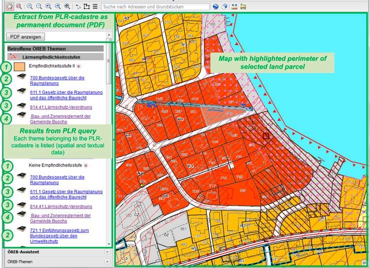
FIG REPORT

FIG PUBLICATION
     NO 61

        CADASTRE 2014 and Beyond

                                             Editor
                                  Daniel Steudler

                                                      SUPPORTED BY

                  International Federation            Federal Office of Topography swisstopo,
                      of Surveyors (FIG)              Wabern, Switzerland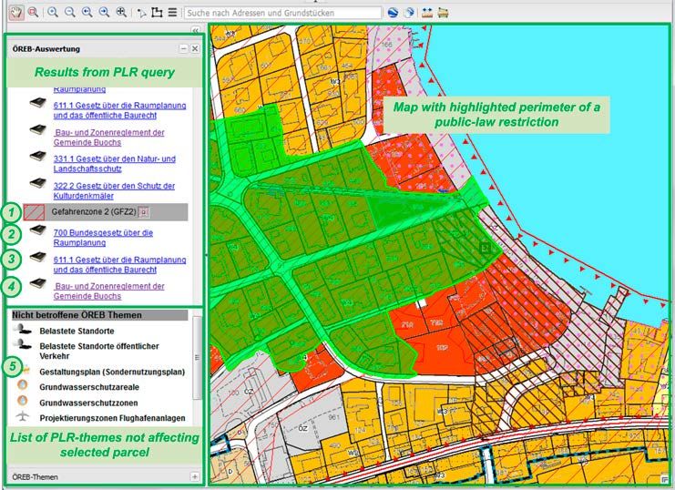
CADASTRE 2014 and Beyond

          Edited by
        Daniel Steudler
Copyright © The International Federation of Surveyors (FIG), May 2014. All rights reserved. International Federation of Surveyors (FIG) Kalvebod Brygge 31–33 DK-1780 Copenhagen V DENMARK Tel. + 45 38 86 10 81 E-mail: FIG@FIG.net www.fig.net Published in English Copenhagen, Denmark ISSN 1018-6530 (printed) ISSN 2311-8423 (pdf ) ISBN 978-87-92853-12-7 (printed) ISBN 978-87-92853-13-4 (pdf) Published by International Federation of Surveyors (FIG) Front cover: The Cadastre 2014 graphic by Werbegraphik Bruno Teucher, Rüdlingen, Switzerland. © Jürg Kaufmann and Daniel Steudler. Back cover: Cadastral reconstruction with overlay maps for field verification. Photo- graph by Alexander Kohli. Editor: Daniel Steudler Layout: Lagarto Printer: 2014 Hakapaino, Helsinki, Finland
CONTENTS
LIST OF FIGURES AND TABLES....................................................................................................... iv
FOREWORD............................................................................................................................................... v
INTRODUCTORY REMARKS............................................................................................................... 1
1 THE CADASTRE 2014 JOURNEY........................................................................................... 2
2 CADASTRE 2014: A BEACON IN TURBULENT TIMES.................................................. 5
3 REVIEW AND IMPACT OF THE SIX STATEMENTS
OF CADASTRE 2014..................................................................................................................10
4 DEVELOPMENTS OUT OF CADASTRE 2014 INTERNATIONALLY
AND IN SWITZERLAND IN PARTICULAR........................................................................18
5 CASE STUDIES FROM NEWLY RENOVATED
LAND ADMINISTRATION SYSTEMS IN THE EMERGING ECONOMIES.............24
6 CADASTRE 2014 – A CASE STUDY FROM SOUTH KOREA.....................................29
7 LADM AND ITS ROLE IN ESTABLISHING CADASTRAL SYSTEMS......................34
8 IMPLEMENTATION OF LADM WITH INTERLIS.............................................................39
9 AN INTEGRATION PLATFORM FOR A SPATIALLY ENABLED SOCIETY............43
10 CADASTRE 2014 IN RELATION TO
SPATIAL DATA INFRASTRUCTURE (SDI)........................................................................49
11 CADASTRE 2014: WHAT LIES BEYOND?.........................................................................54
12 FROM CADASTRE TO LAND GOVERNANCE:
A CADASTRE 2014 OUTLOOK.............................................................................................60
CONCLUDING REMARKS..................................................................................................................67
ABOUT THE CONTRIBUTING AUTHORS....................................................................................68
ACKNOWLEDGEMENTS.....................................................................................................................72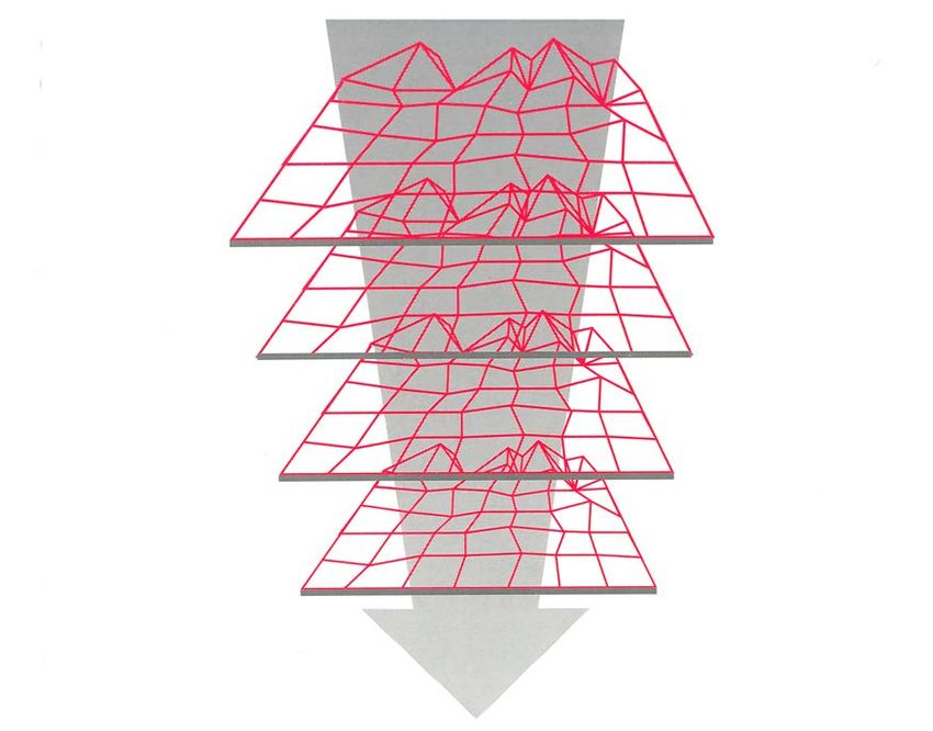
LIST OF FIGURES AND TABLES
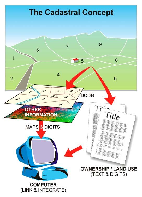
Figure 1 The cadastral concept. 3
Figure 2 Statement 1 of CADASTRE 2014. 10
Figure 3 Statement 2 of CADASTRE 2014. 11
Figure 4 Statement 3 of CADASTRE 2014. 12
Figure 5 Statement 4 of CADASTRE 2014. 13
Figure 6 Statement 5 of CADASTRE 2014. 14
Figure 7 Statement 6 of CADASTRE 2014. 15
Figure 8 The four basic principles for a common data integration concept. 20
Figure 9 Concept of the Cadastre on Public-Law Restrictions (PLR-Cadastre) in 22
Switzerland.
Figure 10 18 registers of the Real Estate Integrated Public Registration System. 30
Figure 11 The ratio of public and private work conducted in cadastral surveying in areas 32
open for the free market.
Figure 12 The LADM International Standard. 35
Figure 13 The continuum of land rights (from UN-HABITAT, 2008, p. 8). 36
Figure 14 Class LA_Party as UML diagram and INTERLIS description. 41
Figure 15 Aggregation and inheritance in UML and INTERLIS. 41
Figure 16 Architecture of GeoApps. 44
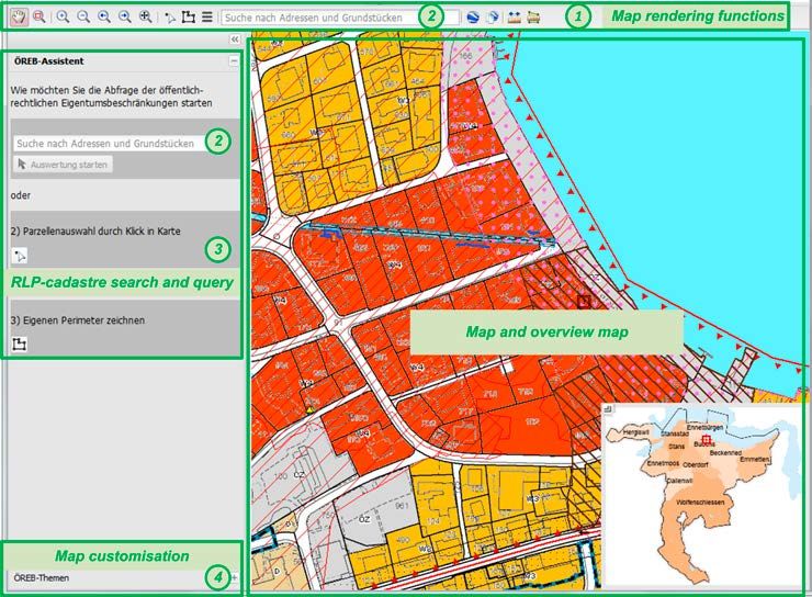
Figure 17 Start window of PLR-Cadastre (http://map.gis-daten.ch/nw_oereb). 45
Figure 18 Dynamic extract with spatial and textual results. 46
Figure 19 Map with highlighted perimeter to easily identify the geometrical extent of a 46
restriction.
Figure 20 The cadastre as core of SDI, SES and ultimately sustainable development. 52
Figure 21 A first attempt from 2010 – for the Australian context. 56
Figure 22 Delivering design, implementation and assessment tools that satisfy emerging 57
societal drivers – a vision for future cadastres?
Figure 23 Evolution of Western cadastral system (developed from Williamson et al., 2010). 60
Figure 24 Key FIG publications include the FIG Statement on the Cadastre (FIG, 1995), 61
The Bogor Declaration (FIG, 1996), Cadastre 2014 (Kaufmann and Steudler,
1998), and The Bathurst Declaration (FIG, 1999).
Figure 25 A CADASTRE 2014 outlook. 63
Table 1 Size of the Korean cadastral system. 29
Table 2 Annual progress of the joint execution project. 32
iv
FOREWORD
What was a simple activity report of Working Group 1 within FIG Commission 7 “Cadas-
tre and Land Management” in 1998, has over the years been translated into 28 languag-
es and was a topic in many forums, panel discussions, roundtables and journal articles.
This simple activity report became a visionary publication, found its way into confer-
ence halls and lecture theatres, and became a reference publication in many teaching
and research institutions. It triggered researches, promoted additional considerations
on issues related to cadastral systems, including developments such as the “Cadastral
Template” and in the field of “Spatial Data Infrastructures”. It also impacted and led to-
wards the recently published FIG Report on “Spatially Enabled Societies” in May 2012.
CADASTRE 2014 became a “brand” by itself.
Though CADASTRE 2014 represents the collective efforts and knowledge of many, con-
gratulations are in order, especially to both Jürg Kaufmann and Daniel Steudler for their
untiring efforts over those many years that led to this definitive publication. Also to be
congratulated are Ian Williamson, the Chair of FIG Commission 7 at that time as well as
the FIG Council presided by Peter Dale. CADASTRE 2014 represents not just ideas and
concepts, but passion and abilities to better comprehend and apply evolving cadastral
concepts.
We are on the threshold of the Post-2015 UN Development Agenda. Last year, the Unit-
ed Nations High-level Panel of Eminent Persons in its report focusing on “New Global
Partnership: Eradicate Poverty and Transform Economies through Sustainable Devel-
opment” proposed how new goals and measurable targets could be framed in the
wake of proposed transformative shifts. We do note that “Land” was mentioned some
23 times within this document. I trust “CADASTRE 2014 and Beyond” is the beginning
of yet another collective and definitive efforts within FIG to contribute towards unlock-
ing the potential of what “Land” is; by “Land” we also mean the seas and its natural
resources, for the well-being and betterment of humanity. Our profession is tempted to
look at our past and present achievements, but foresight is about considering the chal-
lenges of the future, the evolving contribution and relevance of the cadastre towards
the “World We Want”.
It is most fitting that at the silver jubilee Congress of FIG to be held in Kuala Lumpur,
Malaysia this year with the theme “Engaging the Challenge: Enhancing the Relevance”
that we celebrate the immense success of CADASTRE 2014 Vision and launch this new
publication on “CADASTRE 2014 and Beyond”.
We congratulate all contributors and in particular, Daniel Steudler, the editor for all
their efforts towards this publication. We extend our deep appreciation and gratitude
to our Membership and the corps of volunteers within our Federation for their invalu-
able and unselfish contributions in this publication and its related endeavours.

CheeHai Teo
President FIG
April, 2014

                                            v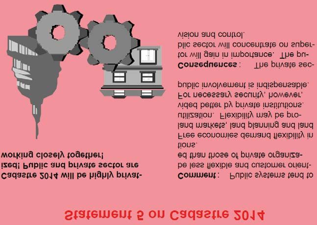
INTRODUCTORY REMARKS
CADASTRE 2014 has been published in 1998 as a result of a working group of FIG-
Commission 7. The working group, active from 1994–1998, had the mandate to identify
trends in the cadastral field and to suggest whereto the cadastre might go for the next
20 years.
The working group carried out two questionnaires in order to identify the trends and
came up with six vision statements, provocative for some, innovative for others. The
publication presented and explained those six vision statements, suggested some new
definitions in order to make the visions possible, and also made some recommenda-
tions for action.
As the year 2014 has arrived, it is very appropriate to take the topic up once more,
to review the statements, to evaluate them and to put them in context. The XXV FIG-
Congress taking place in June 2014 is an excellent opportunity to do that: two special
sessions are part of the congress program and the sections included in this publication
will be presented and discussed.

                                          1
1    THE CADASTRE 2014 JOURNEY
Ian WILLIAMSON, Australia

It is with regret that I cannot be in Kuala Lumpur to personally congratulate Jürg Kauf-
mann and Daniel Steudler on their excellent work over many years on bringing the
CADASTRE 2014 vision to fruition. Jürg was the Chair and Daniel the Secretary for the
Commission 7 Working Group from 1994–98 that produced CADASTRE 2014. However
their contribution was much more than coordinating the working group for the CA-
DASTRE 2014 vision and concept. The resulting FIG report on CADASTRE 2014, co-au-
thored by Jürg and Daniel, reflected many of their own ideas and concepts, but just as
importantly showed their on-going passion to better understand the evolving cadas-
tral concept. Thank you Jürg and Daniel for a job well done.
However an understanding of the CADASTRE 2014 journey requires an appreciation
of the evolving nature of Commission 7 over a ten year period spanning the 1990s.
This period saw the Commission evolve from being European centric concentrating on
land consolidation to a global focus on cadastre, land administration and sustainable
development in both the developed and less developed worlds. This evolution paral-
leled the growth of the FIG itself from a Northern hemisphere focus to a truly global
organisation with the election of an Australian President, Earl James and an Australian
Bureau, the first in the Southern hemisphere and the first in the Asia and Pacific region,
in the early 1990s.
Due to difficulties with the Bulgarian Chair of Commission 7 fulfilling his duties, I be-
came acting Chair of Commission 7 in 1992 and was elected Chair for 1994–98. The sec-
retariat of the Commission also changed from a permanent home in Paris to Australia,
a change that initially caused some concerns but was welcomed over time. During this
period, Commission 7 transitioned to having a global focus on cadastre, land adminis-
tration, land management and sustainable development.
The first major step was changing the name and focus of the commission to “Cadastre
and Land Management”. This was accompanied by a broadening of the mandate of the
Commission, a change hotly debated in FIG. This was not an insignificant development
since it reflected a change of focus from the “old world” to the “new world”. The change
in name was also reflected in a major campaign to promote the Commission but also
to clarify its role and consolidate its mandate.
It is important to acknowledge at this stage that this change and transition would not
have been possible without the strong support of the President and Bureau of FIG, and
particularly the support and vision of country delegates such as Professor Jo Henssen
from The Netherlands and Professor Andrzej Hopfer from Poland, two of the fathers of
Commission 7.
Another key step in the process was a request from the FIG Bureau to clarify the defi-
nition of “cadastre”. This was critical since there were almost as many interpretations
of what constituted a “cadastre” as there were FIG member countries. After many
discussions spanning several Commission 7 meetings the FIG Statement on Cadas-
tre was approved in 1995 as FIG Publication No. 11 (available in 11 languages). The
graphic (Figure 1) that reflects the concept also gained a life of its own and has been
universally used.

                                            2
Commission 7 continued to explore the role of the cadastre in land management, land
administration and in sustainable development, together with the United Nations. This
resulted in the joint FIG-UN Bogor Declaration as part of a United Nations Interregional
Meeting of Experts on the Cadastre in 1996 that set out a cadastral vision and listed
a range of cadastral issues (FIG Publications No. 13A and 13B). This was followed by
the joint FIG-UN Bathurst Declaration on Land Administration for Sustainable Develop-
ment with the theme “Land Tenure and Cadastral Infrastructures for Sustainable Devel-
opment” in 1999 (FIG Publication No. 21).
During this period the Commission continued to discuss and better understand the ca-
dastral concept and the role of the cadastre globally. This included a major focus on
benchmarking cadastral systems, again an initiative that Daniel Steudler and Jürg Kauf-
mann were heavily involved. This initiative was the focus of the Commission 7 Annual
Meeting in Malaysia in 1997 with the results causing considerable animated discussion.
The work was continued by Daniel and Jürg with the Commission 7 Working Group re-
port on “Benchmarking Cadastral Systems” being presented to the FIG General Assem-
bly in 2002.
Figure 1: The cadastral concept.
3The above are only some of the key reports and initiatives, on trying to better under-
stand the role of cadastres globally. They reflect the changes that were occurring in
Central and Eastern Europe in the 1990s with the move from command to market econ-
omies and the role of the European Union in promoting sustainable and market driven
land administration systems, with the UN-ECE Guidelines on Land Administration (ECE/
HBP/96 ) being central. It also reflects a change in technology that saw the creation of
state and national digital cadastral databases that eventually supported the growth
of spatially enabled societies. It was in this context and environment that Commission
7 decided to establish a Working Group in 1994 to research and debate what a future
cadastre would look like in 20 years i.e. in 2014. The Working Group was chaired by Jürg
with Daniel providing critical support as secretary. It brought down its major report
in 1998 at the FIG General Assembly in Brighton UK. CADASTRE 2014 has now been
translated into 28 languages. However the concept and vision gained a life of its own
and has gone from strength to strength, not least due to the drive and commitment of
Daniel and Jürg (www.fig.net/cadastre2014).
Commission 7 continues to research and debate the role of the cadastre in both devel-
oped and less developed countries. One ongoing initiative is the Cadastral Template
where different countries complete a standardized template so that it is possible to
compare and contrast strengths and weaknesses (www.cadastraltemplate.org). The
cadastral template was mandated by a UN Resolution at the 16th United Nations Per-
manent Committee for GIS Infrastructure for Asia and the Pacific at the time I was Chair
of the Permanent Committee’s Working Group on Cadastre. To date 47 countries have
completed the template (www.fig.net/cadastraltemplate/). The Cadastral Template has
been jointly managed by the FIG and the Centre for Spatial Data Infrastructures and
Land Administration, University of Melbourne, however a huge thank you must go to
Daniel Steudler for maintaining the Template and keeping the vision alive. Thank you
Daniel!
The above is just a snapshot that gives an insight into how the cadastral concept con-
tinues to evolve and highlights the central role that the FIG and particularly Commis-
sion 7 has played. This cadastral journey has been assisted by all delegates to Com-
mission 7, past and present and is testament to the commitment of the chairs, office
bearers and working group chairs and members, of the Commission. However there
is no doubt that CADASTRE 2014 has played a central role in this evolution and in this
regard Jürg Kaufmann and Daniel Steudler stand out as the key players providing the
drive and commitment to allow the CADASTRE 2014 vision to come to fruition.
Thank you Jürg and Daniel!
42 CADASTRE 2014: A BEACON IN TURBULENT TIMES
Paul VAN DER MOLEN, The Netherlands
Since the publication of the booklet CADASTRE 2014 in 1998, the International Federa-
tion of Surveyors (FIG) witnessed global developments making the quest for efficient
and effective cadastres increasingly manifest. Although the term ‘cadastre’ became a
bit maligned, because ‘cadastres’ were too much associated with Western type fully
fledged and state guaranteed property titles; global trends indicate that still ‘some-
thing’ is needed to provide land tenure security for unregistered owners or users of
land. That ‘something’ has often been phrased as a ‘land administration system’, a ‘land
recordation system’, a ‘land information system’ or alike, but when the origin of the word
‘cadastre’ (namely ‘list’) is considered we might also say that this ‘something’ is a ‘cadas-
tre’. This section looks at these global developments with a focus on rapid urbanization,
food security, climate change and informal economies, because these developments in
particular are high on the global political agenda: that is to say, often within the overall
goal of poverty eradication. Time and again, the solution – sometimes a major one,
sometimes a minor one – is found to be related to providing tenure security for the
poor, irrespective if they are slum dwellers (urbanization), farmers (food security), land
users and forest dwellers (climate change) or unregistered citizens (informal econo-
mies). But it is clear from a myriad of research that fully fledged property titles are not
considered to be the appropriate solution to achieve that goal. The demand today is
for the recognition of a variety of human-land relationships, adopted in the meantime
by the UN as the ‘continuum of land rights’ (see also section 7 of this publication). The
urge for low-cost information systems to provide for fast and cheap recording of these
different types of rights has become pervasive over the last decades. The statements
and principles of CADASTRE 2014 in the 20 years of existence after their publication did
not lose strength in providing guidance to the design of such ‘fit-for-purpose’ cadastres.
Global developments
The first development to be highlighted is the rapid urbanization. With a world popu-
lation of 6.9 billion people in 2011, it was for the first time in history that a majority of
people live in urban areas. In 2050, the share of the urban population is estimated to be
67%. The population growth, therefore, mainly happens in the cities.
But also the share of the urban population living in slum conditions is increasing: while
in 1990 the number of slum dwellers was 656 million, the number grew to 766 million
in 2000 and to 827 million in 2010. Because of the growing urban population in general,
the percentage as such declines: from 46% in 1990, to 39% in 2000 and to 32% in 2010.
To meet the requirements of sustainable cities, a twin track approach is needed, which
consists of (a) prevention of future slum formation and (b) slum upgrading. Preven-
tion of future slum formation is a matter of urban planning: it is widely observed that
conventional ways of urban planning (the ‘master plan’ approach) completely fails to
deliver appropriate livelihood for the growing number of inhabitants.
When upgrading slums, property rights are considered critical for sustainable approach-
es, besides better governance, financial systems, and social frameworks. Although em-
ployment remains of major importance, frequently, development of informal settle-
5ments is hampered by conflicting and unrecorded ownership claims and double or
multiple sale of the same plot of land. Providing jobs and improvements of the physical
environment should create a social environment where slum residents can improve
their livelihood with social and tenure security as a fundament. In addition to the need
for new forms of spatial planning with their associated need for relevant spatial and
non-spatial information, there is a manifest need to deliver quick and cheap ‘cadastres’
adopting methods of recording various types of land tenure, fitting into the modern
approach to slum upgrading. So, urbanization requires ‘fit-for-purpose’ cadastres.
With regard to food security, the situation currently is that about 868 million people are
undernourished, which corresponds to 12.5% of the world’s population. Problems are
getting worse. Providing food for 9.5 billion people in 2050 requires a 70% increase of
the global food production and up to 100% more in developing countries. This produc-
tion growth can be realized for 80% by higher yields and increased cropping intensity
and for 20% by land expansion: globally, it is estimated that in general 4.2 billion ha is
suitable for agriculture, of which 1.6 billion ha already is being cultivated. Africa holds
60% of the area of uncultivated lands. Analyses show that another 120 million ha of cul-
tivated land is required: in Latin America 52 million ha and in Africa 64 million ha; 32 mil-
lion ha also need to be irrigated. The total yield increase is then potentially 68% in Africa,
89% in East/North Africa, 53% in Latin America, 86% in South Asia and 81% in East Asia.
To boost the agricultural production, two kind of measures are considered to be nec-
essary, namely (a) a change of institutions and policies and (b) a change of technical
approaches.
The technical approach assumes the availability of improved crop varieties, better use
of water, more use of fertilizers, better control of pests and diseases, improve low mech-
anisation, better roads, better electricity supply, and improvement of the currently very
limited technology transfer and adoption.
From an institutional approach, constraints and barriers should be removed in the field
of i) incentive structures, ii) land and water institutions and access to land and water
resources, iii) collaboration, iv) services including knowledge exchange, research and
finance, and v) access to markets. Especially the access to and management of land and
water needs to be improved markedly; the lack of clear and stable land and water rights
and weak regulations and enforcement has contributed to many conflicts over land
access and competition for water use. In particular, the inclusion of customary and tra-
ditional use rights in national legislation is urgently needed; land and water institutions
can be strengthened and common property systems should be protected in order to
providing secure land tenure.
Recognizing that many institutional and technical factors play a role, it remains that
when the ‘land question’ is not brought to a proper solution, problems around land
and water rights will severely obstruct the progress in achieving food security. The reg-
istration of land and natural resource rights is critical to providing security to people in
rural areas and to enable them to negotiate from a better position with both investors
and government. However, levels of rights registration are very low in many parts of
the world, especially in Africa. At the current rate of operation, such systems will take
decades to cover the territory of many countries’, says FAO. This is the real challenge.
When it comes to climate change, it is noted that land makes up a quarter of the
earth’s surface and its soil and plants hold three times as much carbon as the atmos-
6phere. More than 30% of all greenhouse gas emissions (GHG) arise from the land use
sector. Livestock-related emissions of carbon and methane account for 14% of the total
GHG emissions, more than the transport sector. Deforestation, agriculture and livestock
grazing are the major land use changes that increase the release of carbon into the at-
mosphere (31% of human-induced GHG emissions). Land use changes and the burning
of fossil fuels such as oil and coal are the two dominant elements. At the same time, it
is essential to recognize that agriculture has the largest sequestration potential, which
makes it unique. Other sectors can only reduce their emissions, while agriculture also
can remove carbon from the atmosphere.
As said in the paragraphs on urbanization and food security, there are many measures
needed but amongst them ‘land tenure’ and ‘land use management’ are expected to
contribute significantly. Unspecified property rights in forest areas and the allocation of
forest land to commercial users by governments have led to widespread deforestation
as a result of uncontrolled logging and conversion of forest land to other use.
Tenure security is central to the sustainable management of land and other natural
resources and should be mainstreamed into climate change mitigation and adaptation
schemes.
In conclusion, sustainable monitoring systems, land management systems and ‘fit-for-
purpose’ cadastres should serve as a basis for climate change mitigation and adapta-
tion as well as for prevention and management of related natural disasters.
Currently, the informal economy is still substantially present in many countries. Eco-
nomic activities require good rules; these rules include rules which establish and clarify
property rights, reduce the costs of conflicts, increase the predictability of economic
interactions, and provide contractual partners with protection against abuse. The in-
tegration of the informal and the formal economy is therefore steady UN-policy. This
means, that informal settlements inevitably will be connected to the formal economy
in the future. Leaving informal economic transactions unrecorded is unsatisfactory:
how can we maintain that a country shows economic growth when a major part of the
economy is unrecorded? How can we speak about GDP per capita when countries don’t
know the number of citizens? But the problem of informality is worse: most poor peo-
ple in Asia and Africa render unseen because of the lack of up to date civil registration
systems. By consequence they are born and die without ever being counted. Bringing
informality to formality therefore has an aspect of being counted, being registered.
Bringing the informal into the formal systems has always been the goal of land re-
form. Although experiences in the past are not always encouraging, the debate was
reopened 10 years ago by de Soto, urging for the creation of a legal property system
that does justice to the way people in the informal sector deal with possessions, their
attitudes and their informal arrangements. Linking informality and formality is to a cer-
tain extent a matter of recording. When it comes to immovable things, ‘fit-for-purpose’
cadastres should contribute.
In conclusion, the demand is clear: more than ever before, sustainable monitoring sys-
tems, land management systems, and land administration systems (‘cadastres’) need
to serve as a basis for tackling rapid urbanization, food insecurity, climate change, and
informality. The way how governments deal with the land issue is increasingly phrased
as ‘land governance’. Land surveyors should develop the capacity to address a broad
range of people-to-land relationships and provide low cost methods for quick record-
7ing processes, including safeguarding sustainability through sound maintenance and
updating mechanisms.
Brief reflection on the statements of CADASTRE 2014
It will be difficult to achieve the above mentioned social goals without innovative ‘ca-
dastres’. Let’s review the statements of CADASTRE 2014 with regard to their future role
in this innovation, beginning with the first one. In ‘The Economist’ (11 January 2014) we
can read what we also know from scientific publications, namely that in general state
owned lands are not well managed; also an inventory of such lands is often missing.
The same counts for public-law restrictions imposed on private land. As many govern-
ments own large tracts of land, the solution of many societal problems depends on
how these lands and other public interests are managed. Therefore, the first statement,
that CADASTRE 2014 includes both private and public rights to lands, has had great
predictive value.
The separation of maps and registers still hampers the development of information
infrastructures, which are needed to streamline information-based governance. Thus
the second statement, linking maps and registers equally remains true.
The quest for innovative systems cannot be answered without digital technology. The
demand for systems that are ‘cheap’, ‘easy to operate’, ‘quickly perform’, to be handled
by ‘low educated’ people, requires high-tech solutions. Often ‘low-cost’ is associated
with ‘low-technology’, but the reverse is true: without high-tech, no good and at the
same time simple systems are possible, and without high-tech it will not be possible
to employ operators with limited vocational education. The widespread use of mobile
technology and location devices is one example. Therefore we need high-tech, which
means technical system design based on conceptual cadastral modelling, as expressed
by the third statement.
In this context, the adoption of the land administration domain model by the ISO as a
worldwide standard is significant, meanwhile embraced by many countries and adopt-
ed by the UN/Habitat as a precondition for future ‘cadastres’ (see also section 7). Work-
ing manually has proven to be cumbersome when it comes to ‘big data’: working with
‘pen and pencil’ as the fourth statement says, is not sustainable.
Statements 5 and 6, about the ‘privatized cadastre’ and the ‘cost recovering’ cadastre’ are
statements of an organizational nature, which might guide political decisions when ap-
propriate. Reckoning that globally the majority of lands (‘parcels’) is not surveyed or re-
corded, a prediction is that land surveyors – both from public and private sectors – need
to work together to get the job done (‘all hands on deck’), which does not necessarily
create a ‘privatized cadastre’, but at least a robust private sector involvement. Further pri-
vatization will anyhow be considered within the framework of public tasks (governance
issue). Cost recovery of at least the maintenance costs is definitely on the global agenda,
although the financial crisis from 2008 also reveals the darker side of the coin, as can be
seen in Annual Reports and Accounts from various EuroGeographics members in Europe.
In sum, CADASTRE 2014 is a fundament for solving societal problem as described in
the previous paragraphs. For designers of these future cadastres CADASTRE 2014 will
remain a guiding set of statements and principles to take care of.
8Conclusions and laudatio
Indeed, with so many global issues developing at full scale during the last twenty or so
years, the quest for purposeful land information and land information systems or ‘ca-
dastres’ is manifest: whether we review policy documents on urbanization, food short-
age, climate change or economic growth, one way or another security of land tenure
is mentioned as a prerequisite for tackling the problems. Recognizing that concepts
of land information systems (‘cadastres’) and other land related services is an urgent
need, CADASTRE 2014 has been a beacon in this turbulent world, providing the general
statements and principles for thinking about ‘cadastres’ and guiding governmental and
non-governmental organizations to getting their things right. The translation of the
document in some 28 languages is an unparalleled performance. The global survey-
ing community honours the lead-authors Jürg Kaufmann and Daniel Steudler for their
excellent work.
References
Augustinus, C. (2009). Improving access to land and shelter. World Bank, 2009.
de Soto, H. (2000). The Mystery of Capital. Basic Books, Perseus Books Group.
FAO (2012). Voluntary Guidelines on Responsible Governance of Tenure. Rome, Italy.
HLPE (2011). Land tenure and international investments in agriculture. FAO, Rome,
Italy.
Jerven, M. (2013). Poor Numbers. Cornell University Press, London, UK.
Payne, G. (2005). Getting ahead of the game: a twin track approach to improving exist-
ing slums and reducing the need for future slums. Environment and Urbaniza-
tion, Vol. 17, No.1.
Quan, J. and N. Dyer (2008). Climate Change and Land Tenure. IIED/FAO Land Tenure
Working Paper No. 2.
Schneider, F. (2002). Size and measure of the informal economy in 110 countries
around the World. Canberra, Australia.
UN (2011). World Population Prospects: The 2010 Revision. New York, USA.
UN (2012). World Urban Prospects 2011 Revision. April 2012, New York, USA.
UN/Ecosoc (2012). Ministerial Declaration on promoting productive capacity.
UN/Habitat (2008). State of the World’s Cities. Nairobi Kenya.
93 REVIEW AND IMPACT OF THE SIX STATEMENTS
OF CADASTRE 2014
Jürg KAUFMANN, Switzerland
The year 2014 is an excellent opportunity to review what the impact of CADASTRE 2014
has been over the last 16 years since its publication in 1998. It is interesting to see how
further vision documents have been established since, the latest being the report on
“Future trends in geospatial information management: the five to ten year vision” man-
dated by UN-GGIM (2013).
The UN-GGIM report documents the “thoughts of leaders in the geospatial world as to
the future of this industry”. It has a somewhat similar focus as CADASTRE 2014, and it
therefore is well-suited to serve as a benchmark in order to review the six statements
that CADASTRE 2014 has put up. Selected declarations of this report show that CADAS-
TRE 2014 seized the trends and contributes to solve current and future problems.
Statement 1
Figure 2: Statement 1 of CADASTRE 2014.
State of implementation
The concept of extending the content of the cadastre by public-law restrictions has been
widely understood. However, in many countries – especially in developing or transiting
ones – priority is given to the establishment of a private-law property cadastre, which is
urgently needed for the development of the land market as an important pillar for the
national economies and also an indispensable basis for national geodata infrastructures
(NSDI). Implementation efforts, therefore, were undertaken primarily in developed coun-
tries, where the traditional cadastre is more or less complete and in operation. An exam-
ple is New Zealand having published recently ‘Cadastre 2034, a 10–20 Year Strategy for
10developing the cadastral system: Knowing the ‘where’ of land-related rights’ (LINZ, 2014).
Another example is Switzerland, where the cadastre for public-law restrictions on land-
ownership rights (PLR-Cadastre) is currently being implemented. It follows the principles
of CADASTRE 2014 and contains a subset of data restricting landownership rights.
Assessment of impact
The traditional cadastral procedures are applied to secure the high quality needed
for the management of legal arrangements concerning the land and the land tenure,
including the restrictions stipulated by the public laws. The necessary information to
handle these aspects must be reliable and authoritative. CADASTRE 2014 initiated the
process of inclusion of restrictions into the cadastre, which is shown by prominent ap-
proaches in the domain of RRR (rights, responsibilities and restrictions).
The UN-GGIM report addresses the problem of data quality as follows:
2.6.1 The issue of liability for the quality and accuracy of data is likely to grow in promi-
nence over this period. Historically, NMCAs and other providers of geospatial informa-
tion have largely been able to avoid this issue, publishing disclaimers that strive to ab-
solve them from any litigation risk.
2.6.3 The response to this increasing risk over the next few years seems likely to take one
of two forms: a continued acceptance of the risk, with government legislation to mini-
mise the litigation risk; or the development of a ‘warranted’ data model, where at least
some attributes of data will contain a form of guarantee.
CADASTRE 2014 aims exactly at collecting and delivering liable information concern-
ing all types of boundaries (Kaufmann, 2008) to support land management and sus-
tainable development.
Statement 2
Figure 3: Statement 2 of CADASTRE 2014.
11State of implementation
In many countries especially in those where the cadastre has been re-activated or re-es-
tablished, unified organizations combining the cadastral surveying and the land registry
functionality were implemented. Quite often, also a topographic mapping functionality
has been included. In countries, where information technology is well advanced the re-
spective services can now be offered to customers with combined web-based solutions
providing services for both, ‘maps’ and ‘registers’.
Assessment of impact
This convergence of the two functionalities of cadastral systems was often ventured into
based on the recommendation by CADASTRE 2014. The UN-GGIM report speaks there-
fore of national mapping and cadastral authorities NMCAs.
The efficiency of institutions according to the UN-GGIM report is an important issue:
5.1.4 In some countries, a major trend will be to replace obsolete data collected many
decades ago as the economic benefits of up-to-date data can now be quantified; in other
countries a major trend will be adapting business models and access regimes to meet the
changing expectations of an ever-more demanding customer base accustomed to easy
access to online mapping in a user-friendly environment.
Many countries have re-engineered their cadastral services in this sense and the stakehold-
ers in the land market can address a one-stop-shop to settle their land and property affairs.
Statement 3
Figure 4: Statement 3 of CADASTRE 2014.
State of implementation
In the field of data modelling the implementation work took place rather hesitant. A first
step, the description of data sets in UML diagrams was executed and models therefore
exist. But the use of tools with computer-readable conceptual model descriptions and
12automatic format and database generation as the example INTERLIS shown in the CA-
DASTRE 2014 brochure seems only to be well developed in Switzerland.
However, our Dutch colleagues worked hard to make the land administration domain
model LADM an international standard ISO 19152.
Assessment of impact
CADASTRE 2014 started the process to overcome the map paradigm and replace it by a
data paradigm. This effort seems still to be painful for many cadastral professionals. It is
expected that the work on the LADM has a positive impact on the understanding of the
advantages of data modelling. Machine-processability, which will make data handling
much easier will experience a breakthrough in the near future.
The UN-GGIM report underlines the need for machine-processable data modelling:
1.3.2 Semantic technologies will play an important role when it comes to publishing
and making sense of this data, offering the opportunity to create rich machine-process-
able descriptions of data. This will enable knowledge sharing and re-use in addition to
data sharing and re-use.
CADASTRE 2014 identified the trend early and cadastre as the most important base for
GDIs will play a leading role in this field.
Statement 4
Figure 5: Statement 4 of CADASTRE 2014.
State of implementation
In 1994, it was not clear how information technology (IT) would develop in the field
of cadastre. In developed countries IT of course started to play a major role. Based on
the experiences in Switzerland and not opposed by colleagues from Europe and the
rest of the world, the trend towards modern IT cadastres was considered to be sustain-
13able. This proved to be true and nowadays there are no cadastral development projects
without extensive IT component. The process of IT implementation took place step by
step and for a long time the view of the IT developers remained rather traditional. IT
solutions until today are often handling the textual and graphical cadastral data sepa-
rately and the term cadastral map is still used frequently. Meanwhile the notion spatial
data is introduced and cadastral objects are understood as normal data with param-
eters, describing the form and the location.
Assessment of impact
The implementation of IT in the cadastral field was driven by the fact that the penetra-
tion of the market took place in every field of administration. And cadastre is a typical
process of the administration.
The UN-GGIM report emphasizes the important role of information technology
1.3.4 We are increasingly likely to see geospatial information needed to assist the evolu-
tion of this connected ecosystem over the next five to ten years. The emergence and use
of precise location information in this way offers great opportunities and will see it form
a core part of information technology infrastructure. Nevertheless, use in this way will
also present geospatial management challenges over the coming years.
Due to CADASTRE 2014 the profession was well prepared for this new technology with
new opportunities to improve the services of the cadastral organizations.
Statement 5
Figure 6: Statement 5 of CADASTRE 2014.
State of implementation
The implementation of this statement has to respect the fact, that cadastral data is
authoritative and has a long live cycle. Only an organization with a long term existence
14is eligible to secure the existence and the quality of the cadastral data over a long time.
The final responsibility must remain with an authority. However many tasks to be un-
dertaken in the cadastral domain can be entrusted to the private sector.
Assessment of impact
In many countries the land transaction contracts are prepared by private notaries and
the surveying work is outsourced to private surveyors. These professionals and/or
organizations, however, would have to undergo a licensing procedure. Practically all
World Bank projects on cadastre and land registration foresee the involvement of the
private sector mainly to make better use of the resources and to keep the financial load
for the state budgets at a reasonable level.
The UN-GGIM report sees the public-private partnership as an important issue:
4.2.1 The private sector is likely to continue to play a vital role in providing the tech-
nologies identified earlier in this paper that will enable governments, and indeed
other private-sector bodies, to produce and collect the vast quantities of data we are
likely to see in the coming years, to provide the technologies to manage and make
sense of this data and to find value in providing access to the skills necessary to maxi-
mize this data.
5.4.3 However, despite the increase in producers and providers of geospatial informa-
tion, government authorities will retain a key role in other areas of the geospatial en-
vironment where trust in the data produced is seen as vital and where natural govern-
ment monopolies exist.
CADASTRE 2014 was often used to convince politicians to leave the traditional path
and to allow a market for private sector professionals in the cadastre.
Statement 6
Figure 7: Statement 6 of CADASTRE 2014.
15State of the implementation
The aspect of cost recovery is still heavily discussed and no final and broadly accept-
ed solution is implemented yet. In addition the matter depends on politics and state
budgets. Before the global financial crisis, a majority was in favour of free of charge
data. The crisis caused a swing back to cost-recovery of state services.
Assessment of impact
CADASTRE 2014 has initiated many discussions concerning licenses and fees. It, how-
ever, proved to be too ambitious to recover all the cost including the investment in data
acquisition. Therefore, the implementation of Statement 6 concentrates on recovering
on-going costs and if possible a small part of the investment.
The UN-GGIM report deals with the cost recovery as follows:
2.1.7 Because of the fundamental nature of the data, funding will come from central
government sources, supported in some cases by additional funding from global or na-
tional development the process of establishing reliable geospatial information bases is
in its early stages.
2.1.8 In many countries the difficult economic climate has already seen reductions in
central government funding. The accompanying increasing pressure and expectation
for free availability of core datasets will also provide a challenging environment.
2.1.9 As such, one of the major challenges of the next five to ten years will be finding the
funding and business models required to maintain accurate and quality-assured geo-
spatial information, whilst growing the user community for high-quality, accurate and
maintained geospatial information.
CADASTRE 2014 considered the cost recovery aspect at an early stage of development
and has contributed to a better understanding.
Fundamental principles and justification for CADASTRE 2014
Besides the six statements, CADASTRE 2014 also mentions seven fundamental princi-
ples for future cadastres: The most important of them are the principle of legal inde-
pendence and the principle of location of all land objects in a common reference frame.
In addition a justification for the future cadastral systems is given. CADASTRE 2014 sup-
ports sustainable development, creates political stability, omits conflicts of public and
private interests, supports the economies, and offers flexibility and effectivity for future
development.
Finally the CADASTRE 2014 publication makes some recommendations: for surveyors
to undergo the necessary mental change, for FIG to promote and sponsor a compe-
tence centre, and the national professional organizations to prepare the successful re-
alization of modern cadastral systems.
Conclusions
CADASTRE 2014 interpreted trends correctly and made feasible proposals to adapt the
cadastral systems to modern requirements. It made the step away from a map-centric
16view and laid the basis for a data-centric view and thus initiated the discussions to-
wards Spatially Enabled Societies. The UN-GGIM report confirms that CADASTRE 2014
was on the right track, but also that it will take some more time to spread the word of
modern cadastral systems around the globe.
However, the comparison with the UN-GGIM Future trend analysis shows that
CADASTRE 2014 did not deviate from the trends it identified at the time.
References
Kaufmann, J. and Steudler, D. (1998). Cadastre 2014 – A Vision for a Future Cadastral
System. Rüdlingen and Bern, Switzerland, July 1998.
Kaufmann J. (2008). The Boundary Concept: Land Management Opportunities for
Sustainable Development Provided by the Cadastre 2014 Approach.
FIG Working Week 2008, Stockholm, Sweden.
LINZ (2014). Cadastre 2034, A 10–20 Year Strategy for developing the cadastral system:
Knowing the ‘where’ of land-related rights. Land Information New Zealand,
February 2014. .
Steudler, D. and Rajabifard, A. (2012). Spatially Enabled Society. FIG Publication No. 58,
April 2012.
UN-GGIM (2013). Future trends in geospatial information management: the five to
ten year vision. United Nations Committee of Experts on Global Geospatial
Information Management, July 2013.
174 DEVELOPMENTS OUT OF CADASTRE 2014
INTERNATIONALLY AND IN SWITZERLAND
IN PARTICULAR
Daniel STEUDLER, Switzerland
In the first few years after the publication of CADASTRE 2014 in 1998, there were many
activities in quite a few countries discussing the six vision statements. This section looks
briefly into some of the activities, what further developments took place, and what the
effect has been in Switzerland.
Translations and initiatives
Within the first two years after its publication, CADASTRE 2014 has been translated by
FIG members into nearly 20 languages. Over the following years, more translations be-
came available; the most recent translation was added in 2013. CADASTRE 2014 is to-
day now available in 28 languages (FIG, 2014).
A very relevant initiative has been taken by Bennett et al. (2010), who published an
article confronting the international community of cadastral surveyors with sugges-
tions of how the cadastre might further develop in the next 20 years. They argue that
over the last thirty years issues such as “multipurpose cadastres, CADASTRE 2014, and
sustainable land administration have radically altered the understanding of cadastres
and their potential”. They continue to be relevant, but as the global context is develop-
ing, cadastral science must anticipate and facilitate emerging change. Bennett et al.
(2010) present six design elements relating to the role and nature of future cadastres
as a starting point for further dialogue (compare also section 11 of this publication).
This dialogue has been followed up by the magazine “GIM International” (Lemmens,
2010a and 2010b), who invited international experts to reflect on Cadastre 2014 and
Bennett’s suggestions. This was followed by a panel discussion at the FIG Working Week
in Marrakech (FIG, 2011). GIM International honoured the event with a dedicated spe-
cial FIG issue (GIM, 2011). This special issue includes an interview with Hernando de
Soto, the paper of Bennett et al. (2010), and the two articles with the reflections of the
international experts (Lemmens, 2010a and 2010b).
Most recently in October 2013, the FIG-Commission 7 together with UN-Habitat and
the Fédération des géomètres francophones (FGF) organized an International Sym-
posium and Workshop on Land Policies and Land Governance in Yaoundé, Cameroon.
Along with other issues such as fit-for-purpose land administration, CADASTRE 2014
was presented again and discussed, potentially playing an important role in the devel-
opment of cadastres in the African context.
A most prominent initiative has been taken by Lemmen (2012) (compare also section
7 of this publication), who brought Statement 3 on data modelling onto the global
agenda. With the establishment of the Land Administration Domain Model (LADM),
he made a significant contribution to the recognition and application of standardized
data models in the cadastral field. The LADM was also adopted as an ISO standard in
2012 (ISO, 2012).
18CADASTRE 2014 is also given a lot of attention in Australia and New Zealand, where
strategic initiatives by the title of Cadastre 2034 are being taken. New Zealand (LINZ,
2014) recently published a 10–20 year strategy for developing its cadastral system; this
new strategy also builds on CADASTRE 2014 elements. In Australia, the Intergovern-
mental Committee on Surveying and Mapping (ICSM, 2013) is recognizing the impor-
tance of the cadastral system and its role in the changing nature and increased com-
plexity of urbanisation, rapid technological development and public expectations of
public services. The five goals for Cadastre 2034 also include elements such as “broader
legal and social interests on land”, “survey accurate representation”, and a “federated
cadastre based on common nationwide standards”.
Four principles of the common data integration concept
Another initiative that strongly built on the CADASTRE 2014 statements, was the
publication of the FIG-Task Force on Spatially Enabled Society (Steudler and Rajabi-
fard, 2012). It defined six basic elements, without which a society cannot call itself
spatially enabled. One of those basic element has been the definition of the “com-
mon data integration concept”, which ensures that spatial data can be shared and
integrated across institutions and organizations for the benefit of all members of the
society at large.
This common data integration concept stems in principle from the original CADASTRE
2014 statement on data modelling, which also included the definition of layering of
data topics by the principle of legal independence. This definition has not really been
given a lot of attention, as it was considered too much on the technical side. However,
it has a huge conceptual implication.
In order to benefit on a macro-economic level, spatial data need to be organized in
such a way that it can be integrated and shared among stakeholders. Interoperability is
key to make best use of geographic information. This can be achieved by establishing
a spatial data infrastructure, which respects the following four basic principles of the
common data integration concept as illustrated in Figure 8.
The first principle is to respect the legal and institutional independence of data
providers and stakeholders. Spatial data that have to be integrated in a national or
subnational infrastructure often originate from different stakeholders. The first natural
reactions of stakeholders, when being asked to open or share their data, is a reaction of
protection and defence. In order to overcome the stakeholders’ fear of loosing control
over their own data, it is important to respect their legal and institutional independ-
ence and to recognize it as a crucial element for cooperation and data interoperabil-
ity. Technocrats often neglect this effect and blockages are provoked, which then take
months or even years to overcome.
There is a simple mechanism that helps to guarantee the independence of stake-
holders. This is that data are to be organized in independent topics, each defined
by separate data models. Each data model deals with only one (legal) topic without
interference or logic implications from other topics. This topical separation of infor-
mation can also be applied for cadastral data, where for example in Switzerland the
domain model for cadastral surveying consists of 11 different topics, i.e. 11 separate
data models.
19There are several benefits when this principle is being respected:
– topics from different legal domains can be dealt with independently;
– the legal, institutional and organizational independence of stakeholders can be
respected;
– topics/layers can be added or removed – according to needs – without affecting
the whole system or infrastructure;
– responsibilities and workflow for each topic can clearly be defined and assigned;
– data models remain lean and manageable, and modular and flexible data qual-
ity tools can be applied.
The second principle of the common data integration concept is to use a standard-
ized data modelling concept. This is useful for the clear definition, description and
exchange of data and information. This conceptual element has been reinforced by the
Land Administration Domain Model (LADM), which provides basic principles for estab-
lishing data models for land tenure systems. The standardized data modelling concept
ought to be used not only for the cadastral domain, but for all other information do-
mains of local, national or regional SDIs.
The third principle is that in the data models for each data topic, there are no logic rela-
tions to objects in different topics. The only link between objects of different topics
is through the geographic location. When this principle is applied, it becomes possible
not only to manage all data in a common system, but also to rely on the geographic
Examples of Stakeholders, Textual data Spatial data Spatial data
legal topics Institutions infrastructure
Water/noise protection Local government
Environ. protection Environ. dept.
Land-use planning Planning dept.
Corporations,
Collective land rights
tribes, clan
Land valuation Government
Public-law restrictions Government
Land registry, National government
cadastre State government
Local government
Four basic principles 1) to respect the legal/institutional independence of stakeholders
for a common data 2) to use a standardized data modelling concept
integration concept: 3) no logic relations to objects in different topic except through
geographic location
4) to use a common geodetic reference framework
Figure 8: The four basic principles for a common data integration concept.
20You can also read