Central Indiana September 2021 Climate Summary
←
→
Page content transcription
If your browser does not render page correctly, please read the page content below
Central Indiana
                      September 2021
                     Climate Summary
                  30th Warmest on record at Indianapolis
                  23rd Wettest on record at Indianapolis

Temperatures
September 2021’s very warm temperatures averaged about 3 degrees above normal across
central Indiana, which included generally near-normal readings for the first 11 days, several ~3-
day periods of unseasonable warmth between the middle and very end of the month, and
several days of below normal temperatures that started on the 22 nd. Afternoon highs in the
mid-80s to low 90s were common on the 11th-14th, 17th-19th, and 27th-30th. Perhaps
surprisingly, this was only the 5th warmest September of the last decade at Indianapolis, due to
several anomalous recent Septembers between the record warmest (2019) and two others in
the all-time top-15 warmest (2018, 2016). Monthly maximums were reached on the 14th, 18th,
and 19th across the region, when most locations reached the upper 80s to low 90s. The coolest
morning for nearly all sites was observed on September 24th as widespread low to mid 40s
were found across the region.
After a hot and humid end to August, September started near to slightly below normal as a
seasonably strong mass of Canadian high pressure passed from the Great Lakes to the upper
Ohio Valley. Most locations dropped into the 50s on the mornings of both the 2nd and 3rd, with
the lowest mark of 51F at New Castle 3 SW (Henry Co.) both mornings. On the 3rd, Indianapolis
Int’l Airport’s high of 78F was only the second sub-80F max in 49 days.
On the 6th, readings at most locales saw a diurnal spread of 25F or greater, with the Beck
Agricultural Center northwest of West Lafayette (Tippecanoe Co.) climbing from 55F to 87F (a
32 degree rise). Most sites reached the mid to upper 80s on both the 6th and 7th, with Shoals 8
S (Martin Co.) peaking at 89F and 88F, respectively. Following the next cold frontal passage
early on the 8th, high pressure and dry northwesterly flow aloft promoted generally seasonable
temps through the morning of the 11th. Another transition then occurred during the day of the
11th as robust south-southwesterly breezes again boosted readings to very warm levels, with Rockville (Parke Co.) climbing form 60F to 89F (a 29 degree rise). On the 12th-14th, all 1st-order airports averaged at least 10 degrees above normal courtesy of persistent south-southwesterly winds. The 14th was the most anomalous per lows near 70F at most locations ... with afternoon maximums as high as 92F at the Southwest Purdue AG Center northeast of Vincennes (Knox Co.). The 15th-16th included a brief respite to more seasonable readings as high pressure crossed the southern Great Lakes. The 17th-19th then saw upper ridging build over the Mid-West, with the generally southerly flow again boosting afternoon highs near 90F, while the rather humid air mass held morning lows in the 60s. The 18th was the hottest day of the month for most sites, with over a dozen COOP stations and most 1st-order airports reaching the low 90's, including 93F at Shelbyville Municipal Airport. Tipton 5 SW (Tipton Co.) made it into the 90s all three days, including 92F on the 18th and 19th. 90+ marks were hit on two of the three days at 5 other stations, mainly along the Wabash Valley. Late September featured a regime change to noticeably cooler fall-like weather following the passage of both a seasonably strong cold front on the 21st...and the system’s associated amplified trough, which cut-off over southern Indiana on the 22nd before twisting northward into Canada. This cold core passing over Indiana, combined with cloudy and rainy conditions, held the 22nd’s high temperatures 10 to 20 degrees below normal at most locations; the lowest reading was 53F at Kokomo 3 WSW (Howard Co.). Broad high pressure quickly followed the departing cut-off on the 23rd, maintaining below normal temperatures while bringing the first 40s to most of the region since late May. All first-order airports recorded their first 50F or lower temperature on the evening of the 23rd, which at Indianapolis tied for the 15th latest, or 90th percentile; the record latest being October 5th (2019). The 24th featured the month’s coldest morning for essentially all locations, as low to mid 40s prevailed. 40F was hit at both Rockville and New Castle 3 SW. A reinforcing cold frontal passage early on the 25th kept temperatures near to slightly below normal through the morning of the 26th. The colder portions of the region recorded lows in the 40s for four consecutive days, 23rd-26th, including Bloomington and Terre Haute. The 26th featured the most pronounced transition of the month, as south-southwesterly breezes that gusted as high as 28 mph boosted a 30-35 degree warm up for most sites, with Terre Haute jumping from 43F to 79F (a 36 degree rise). This ushered in consistently warm conditions that lasted through the end of the month, as most sites averaged ~10 degrees above normal over the 27th-30th. The 80s were common across central Indiana for the final four days as ridging prevailed over Indiana, with a few 90F+ observations with Lafayette and Perrysville 4 WNW (Vermillion Co.) both hitting 90F on 9/27, to Shoals 8 S reaching 91F on 9/28. September 2021’s above normal temperatures continued the trend from August 2021’s warmth, but were in contrast to the near-normal readings observed in September 2020.
September        September         Highest           Lowest
             Site                 2021             2021         Temperature       Temperature
                              Average Temp     Dep from Nml
Indianapolis Int’l Airport        70.2             +2.4        89 on 18th, 19th   46 on 24th,26th
Lafayette (*)                     69.6             +4.1        91 on 18th, 19th     42 on 24th
Muncie                            70.1             +2.9          91 on 18th         49 on 24th
Terre Haute                       70.1             +3.5        91 on 14th, 18th     42 on 24th
Bloomington                       69.5             +3.0        89 on 14th, 18th     44 on 24th
Shelbyville                       70.5             +3.0          93 on 18th         45 on 24th
Indianapolis Eagle Creek          70.8             +3.2          91 on 18th         46 on 24th
               (*) − Lafayette’s data is missing September 1’s minimum temperature

 At Indianapolis, September 2021’s daily average temperatures were above normal on 18 days
 and below normal on 10 days. It was the 30th warmest September for the Indianapolis Area
 since weather records began in 1871, placing it in the 80th percentile.
Precipitation Outside of the winter, September is normally central Indiana’s driest month, with the 2.50” to 3.60” normally seen by most locations, in stark contrast to the early summer peak (normally ~5.00” in June). 2021, however, contrasted this climatological pattern, with most of the region totaling a much-needed 3.00-7.00”, including 5.25” at Indianapolis international Airport, which was 167% of normal. The Labor Day weekend began with a soaking rain on the 4th courtesy of a wave riding along a weak cold front, as most locations picked up 0.50-1.00". A band of 1.00-2.00" totals was found along and north of the I-70 corridor, with greatest reports of 2.54" near Perrysville (Vermillion Co.), 2.11" in Cumberland (Hancock Co.) and 2.00" near Winchester (Randolph Co.). On the night of the 7th-8th, a wide line of thunderstorms brought generally light rainfall amounts, except for far northwestern counties where a second line of storms crossed before dissipating, bringing 1.21" to Pence (Warren Co.). Widespread showers and storms steadily crossed the region late on the 14th through the morning of the 15th, bringing isolated 1.00-3.00" rainfall totals. Greatest reports included 2.79" at the Muncie wastewater treatment plant, 2.51" south of Shoals (Martin Co.), and 1.87" in Greenwood (Johnson Co.). The 19th-23rd brought a staunch pattern change of several rainy days from both a slowly-passing cold front during the day of the 21st ... and the system's subsequent upper trough cutting off to a stacked low on the 22nd, while sliding northward along the Indiana-Ohio border. Several rounds of showers and isolated thunderstorms, enhanced by Hurricane Nicolas' remnant moisture, crossed the region from the evening of the 19th through pre-dawn on the 20th, with greatest rains along an axis from 1.56" in Ellettsville (Monroe Co.) to 1.99" east of Shoals (Martin Co.). Welcomed soaking rains then continued into the daytime on the 20th south and east of Indianapolis, before isolated afternoon cells popped later across the rest of the region. These additional 1-day rains included several patches of 1.00-2.00" south/east of the I-70/I-69 corridors, with the greatest observation totaling 2.19" in Columbus (Bartholomew Co.). Most locations saw about a 12 hour lull in rain late on the 20th / early on the 21st, but not before widespread 2-day totals of 1.00-2.00" had fallen across south central and southeastern counties, with around 2.50" in the Columbus area, and 3.06" reported from Williams 3 SW (Martin Co.) ... while only 0.25-0.50" was recorded at most locations north of I-70. Part 2 of the extended rainy period started as the cold front slowly crossed the region from west to east on the 21st, although this produced only isolated rains, west of I-69, in the AM hours ... before scattered rain developed behind the front, in the evening, over the entire region. Generally widespread rain continued for the next 24 hours as the upper low traversed the southern and then eastern periphery of the region, while becoming stacked and cut-off from the main jet stream. Rain tapered off from southwest to northeast during the evening of the 22nd, although occasional light showers then lingered across far northern and northeastern zones through midday on the 23rd. Rainfall totals for this post-frontal 2-day period ranged from just over 1.00" along the Wabash Valley to 2.00"+ for most central and eastern zones. A 3.00-
4.00" bull’s-eye extended from Bloomington to Columbus, and northward across eastern
portions of the Indianapolis metro, to northern Hamilton County, with maximum reports of
4.25" at New Palestine (Hancock Co.) and 4.18" in Franklin (Johnson Co.).
Overall 4-day precipitation totals for the 19th-23rd were 2.00-4.00" for most locations, while a
5.00"+ peak was measured over the counties within the 21st-22nd’s maximum, which were
south of I-70. 5.87" at Williams 3 SW was the greatest total, while 5.61" was measured at
Amity (Johnson Co.). The west-east gradient in overall rain totals was pronounced across the I-
69 corridor, and especially Marion County - from 2.94" near Eagle Creek Airpark to nearly 5.00"
from Southport to Cumberland. ... The soaking rains of the 22nd brought central Indiana's first
concerns of river and stream flooding since the third week of July, although rather dry
antecedent soils greatly mitigated this threat. Several creeks approached bankfull conditions.
Youngs Creek at Amity reached minor flood stage for over 36 hours, from early evening on the
22nd through dawn on the 24th, cresting just below moderate flood. Minor flooding also briefly
occurred at both the North Salt Creek at Nashville (Brown Co.) and Sugar Creek near Edinburgh
(Johnson Co.), on the evenings of the 22nd and 23rd, respectively. Several other sites peaked
just below flood stage throughout the 23rd, mainly in the vicinity of the East Fork White River,
and from Marion County into all northeastern counties.
A drier, northwesterly upper-level flow then prevailed for the remainder of the month, with
only light rainfall from showers accompanying a frontal passage early on the 25th ... and locally,
briefly moderate showers, during the evening of the 27th to very early on the 28th, also bringing
light rains immediately south and east of Indianapolis.
September 2021’s near to well above normal precipitation reversed August 2021’s overall dry
trend. These ample rains boosted Indianapolis’ year-to-date total to 36.56”, 2.52” above
normal. September 2021’s wet trend was in sharp contrast to September 2020, when
Indianapolis’ 0.12” total made for the driest September on record, and tied for the 4th driest
month since records began in 1871.
Site September September 2021 Wettest Day Longest Dry Stretch
2021 Diff. from Normal
Precipitation
Indianapolis Intl AP 5.25 +2.11 2.07 on 22nd 6 days, 8th-13th
Lafayette 2.75 +0.16 0.87 on 22nd 6 days, 8th-13th
Muncie 5.17 +2.08 2.06 on 22nd 6 days, 8th-13th
Terre Haute 2.95 +0.02 0.91 on 22nd 5 days, 26th-30th
Bloomington 4.83 +1.23 1.39 on 22nd 6 days, 9th-14th
Shelbyville 5.05 +1.91 2.30 on 22nd 6 days, 8th-13th
Indy – Eagle Creek (*) 1.28INC M M on 22nd 6 days, 8th-13th
(*) − Indianapolis Eagle Creek is missing September 20-22 precipitation data
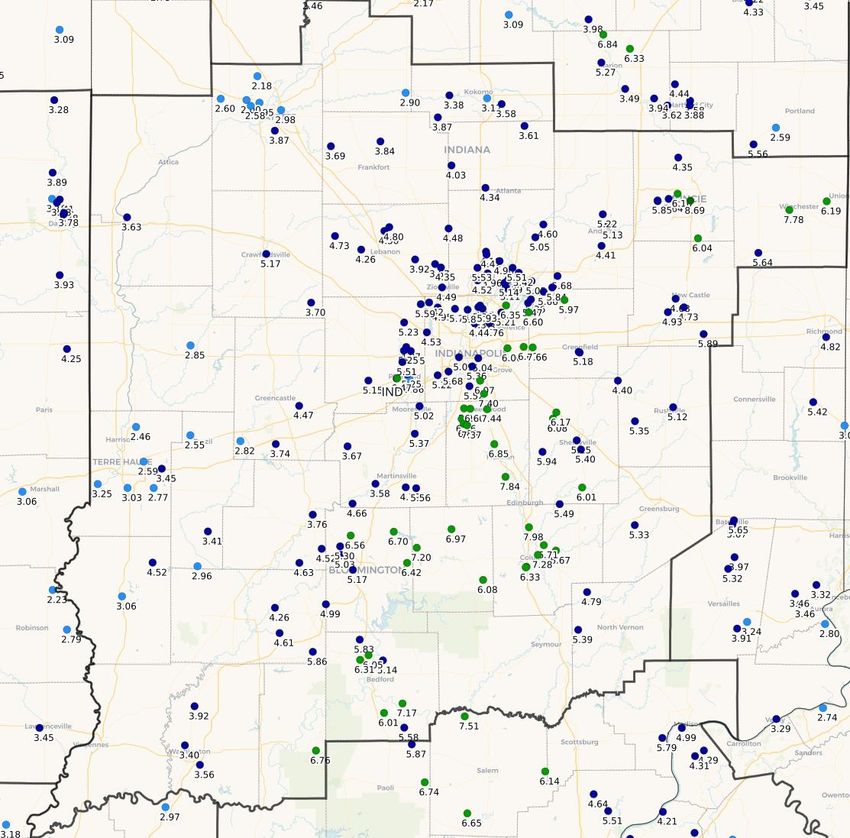
September 2021 was the 23rd wettest for the Indianapolis Area since weather records began in 1871.September 2021 Total Precipitation, Through the Morning of 10/1
As Reported By Central Indiana CoCoRaHS Observers
For the period 700 AM EDT 9/1/2021 -to- 700 AM EDT 10/1/2021. Data is unofficial.
Rain totals were greatest in Muncie, as well as over the east side of Indianapolis and points south...
the Wabash Valley saw near-normal rainfall, while the rest of central Indiana was above normal.Severe Weather
September 2021’s thunderstorms were sporadic with only two noteworthy episodes. On the
evening to early morning of the 7th-8th, an approaching cold front brought widespread
thunderstorms with a few embedded, briefly strong cells.
On the 14th, a very warm and rather humid air mass combined with an approaching cold front
to set off numerous afternoon/evening thunderstorms. A couple cells were marginally severe
in far northeastern counties, with reports of a downed tree and power lines, and shingles blown
off a house, in and to the south of Muncie ... as well as a tree downed to the east of Farmland
(Randolph Co.).
For info on severe weather in other areas during September, visit the Storm Prediction Center
“Severe Weather Event Summaries” website at spc.noaa.gov/climo/online
Miscellaneous
The month’s maximum wind gust at the Indianapolis International Airport was 40 mph (from
the northwest) on the 22nd. Greater peak wind gusts at other 1st-order airports included 43
mph at Muncie (from the northwest) on the 14th, and 41 mph at Lafayette (from the north) on
the 7th.
Fog occurred at Indianapolis on 8 days, with no dense fog observed. All 1st-order airports
outside of Marion County saw fog more often, on 17 days at both Bloomington and Terre Haute
and on 14 days at Shelbyville. Bloomington saw fog every day during the 15th-22nd, while all
sites observed fog during the damp 20th-22nd. Dense fog occurred at Terre Haute, Bloomington
and Lafayette on 4, 3, and 2 days, respectively.
Thunder was reported on 5 days at Bloomington and Shelbyville, 3 days at Indianapolis, and 2
days or less elsewhere … with all sites reporting thunder on the 14th.
October 2021 Outlook
The official outlook for October 2021 from the Climate Prediction Center indicates above
normal temperatures are likely for central Indiana. The normal October temperature for
Indianapolis is 55.5 degrees.
The outlook also indicates equal chances of above, below or near normal precipitation for
central and northeastern counties, with a slightly greater chance of above normal precipitation
southwest of the I-65 corridor. The normal October precipitation at Indianapolis is 3.22”.
Data prepared by the Indianapolis Weather Forecast Office’s State Climate Team
Questions should be referred to nws.indianapolis@noaa.govYou can also read