Central Indiana June 2021 Climate Summary
←
→
Page content transcription
If your browser does not render page correctly, please read the page content below
Central Indiana
                         June 2021
                     Climate Summary
               33rd Warmest on record at Indianapolis
            Tied for 13th Wettest on record at Indianapolis

Temperatures
June 2021’s daily temperatures were considerably less anomalous than May 2021’s, with the
month featuring longer periods of very warm to hot conditions and a few short cooler periods
under Canadian high pressure. If a heat wave is considered to be a prolonged period of high
temperatures hitting 90F or higher, then the only borderline occurrence was during the second
week of the month, in isolated locations; the warmer periods were driven more by warm,
humid mornings than afternoon maximums.
The cool late May blast that brought several morning lows into the 40s lingered into June, with
essentially all sites at least slightly below normal through the 2nd, as readings diurnally ranged
from the 50s to the 70s. A slow moderation lead to a prolonged humid, and at least briefly hot
period during June 7th-13th, as a disorganized upper ridge built over the central US. Nearly all
1st-order airports peaked in the 90s on the 11th and 12th, with 90F+ heat continuing at Terre
Haute and Shelbyville through the 14th. The 12th was the hottest day of this warm spell at all
sites, with both Lafayette and the Purdue farm northwest of West Lafayette hitting 98F, while
95F was reached at both the Purdue farm northeast of Vincennes (Knox Co.) and Shoals 8S
(Martin Co.). Perhaps more pronounced was the humidity which held Indianapolis’ low
temperatures from 68F to 71F during the 7th-13th, with similar trends seen at other sites.
Northerly winds brought a respite of milder Canadian high pressure into Indiana for June 15th-
17th as temperatures dropped to the mid to upper 50s all three mornings at essentially all sites.
This drier air’s temperature was quick to rebound, however, as robust southwesterly flow
returned. June 18th-20th was quite warm to briefly hot, as many sites recorded their highest
temperature of the month on the 18th (hours before the severe weather outbreak, see below).
The Vincennes and Shoals sites both hit 95F again.
A broad and deep, yet quick-moving upper trough provided another quick blast of much cooler
air to the region on June 22nd-23rd. The 22nd was the cooler day, with morning lows into at
least the 50s and daytime highs only rebounding into the low to mid 70s despite the strongest
sun angle of the year. Crawfordsville 6SE plummeted to 46F, while Tipton 5SW dropped to 47F.
Heat and humidity then returned for June 2021’s last several days. June 25th-30th saw morning
lows remain at 70F or above at Indianapolis. Daytime highs were less impressive as the humid
air and frequent showers/thunderstorms prevented any prolonged heat, although the low 90s
were reached at several sites on both the 28th and 29th.
Overall, June 2021’s generally 1.5F to 2.5F above normal temperatures reversed the rather cool
trend of May 2021 ... while continuing the rather warm trend of June 2020.
June 2021 June 2021 Highest Lowest
Site Average Temp Dep from Nml Temperature Temperature
Indianapolis Int’l AP 74.1 +1.6 93 on 12th, 18th 53 on 22nd
Lafayette 77.3 +6.6 100 on 18th 53 on 16th, 22nd
Muncie 75.8 +2.5 95 on 12th 52 on 22nd
Terre Haute 74.9 +2.2 96 on 18th 54 on 17th, 22nd
Bloomington 74.2 +2.2 94 on 12th, 18th 53 on 23rd
Shelbyville 75.7 +2.5 96 on 18th 54 on 22nd
Indianapolis Eagle Creek (*) 74.6 M 94 on 12th 53 on 22nd
(*) − Temperature data missing for Indianapolis Eagle Creek on June 21 and June 20’s max temp.
At Indianapolis, June 2021’s daily average temperatures were above normal on 18 days and
below normal on 9 days. It was the 33rd warmest June for the Indianapolis Area since weather
records began in 1871.
Precipitation
June 2021 was wetter than normal for most of central Indiana, in both rainfall frequency and
amounts. The couple 4-5 day blasts of cool, dry Canadian air through the middle of the month
acted as intermissions between distinct periods of daily showers. The month started wet on
the 1st-3rd, especially across southern counties where 3-day totals were as high as 3.66” at
Shoals 8S (Martin Co) ... with significant rains falling on the 2nd at Indianapolis (1.19”),
Bloomington (1.56”) and Shelbyville (1.21”). The next round of summer showers fell from the
8th-12th, again with the most common daily totals of 0.50-1.00” generally falling along and/or
south of the I-70 corridor ... with the greater 5-day rainfall totals around 2.00” for several
counties, and as high as 3.70” near Flat Rock (southern Shelby Co) ... and the greatest 1-day
sum of 2.25” on the 12th near Warren Park (Marion Co).
Several rounds of intense storms on the 18th-19th led to extreme rainfall totals of ~3-8” along a
broad Terre Haute – Bloomington – Columbus zone, including 7.42” at Ellettsville 0.6 SSE
(Monroe Co) and 7.41” at Spencer (Owen Co), the latter being the greatest 1-day total in the
station’s 76-year record ... while less-extreme heavy rains of 1-3” fell on several counties to the
north and south of the bulls eye. Over 30 of central Indiana’s river and stream gages rose toflood stage following this event, including moderate flooding on the North Fork Salt Creek at
Nashville, Haw Creek at both Hope and Clifford, and Salt Creek at Harrodsburg. Moderate
flooding on the East Fork of the White River at Seymour crested just shy of major flood stage.
The month ended on a humid and showery note, as showers and thunderstorms were common
for June’s last seven days, especially along the Wabash River Valley from Kokomo to Terre
Haute. The 24th-26th rains totaled around 2.00” to well over 3.00” for northwestern zones,
including 3.73” in Covington (Fountain Co). On the 27th, many locations saw around 1.00”, with
2.60” at West Lafayette 3.3 WNW, and several reports of 1.15-1.55” over the portions of Owen
and Monroe Counties that saw the 18-19th bulls eye. The 29th’s storms brought about 2.00” to
much of northern Marion County, including 2.35” in Williams Creek ... before the month ended
on a rainy note: the 30th‘s early morning and evening storms totaled 0.50-1.00” on many sites,
including 1.43” at the Indianapolis Int’l Airport.
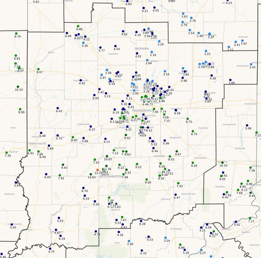
Normal June rainfall totals range from 4.50 to almost 6.00” across central Indiana. June 2021’s
totals encompassed near normal to anomalously high values, with the region split between 3-6”
over most north-central/northeastern zones, and generally 6-10” along the southern half and
far northwestern counties ... while most of Marion County saw 6-9”, which was greater than
most adjacent counties. There were several exceptions to this pattern, however, including:
several sites totaled over 10” in northwestern Monroe County, as well as neighboring portions
of Owen and Morgan Counties ... as well as only 5-6” over far southwestern counties. The
region’s June total precipitation ranged from around 2.50” in Tipton County to nearly 13” in
southeastern Owen County.
The month’s generally wet pattern across central and southern counties was also exhibited at
Indianapolis, Bloomington and Shelbyville, which each saw 10 days record 0.10”+ (normal for all
sites is 8), while Indianapolis recorded measureable rain of 17 days (normal is 12), and
Shelbyville’s 8 days of 0.50”+ was double their normal tally. Following the modest rains of this
April and May, Indianapolis’ year-to-date total was 2.86” below normal. However, June’s
anomalously high rainfall essentially erased this deficit. Looking back at June 2020,
Indianapolis’ total precipitation was an adequate, yet near-normal 4.44”; June 2021’s sum was
152% of normal.
Site June 2021 June 2021 Wettest Day Longest Dry Stretch
Precipitation Diff. from Normal
Indianapolis Intl AP 7.51 +2.56 2.16 on 19th 5 days, 13-17th
Lafayette 4.35 -0.21 1.26 on 27 th 5 days, 13-17th
Muncie 4.18 -0.63 0.79 on 12th 5 days, 13-17th
Terre Haute 6.59 +1.95 3.54 on 19th 5 days, 13-17th
Bloomington (*) 8.46 INC M M 6 days, 12-17th
Shelbyville (*) 8.31 INC M M 5 days, 13-17th
Indy – Eagle Creek (*) 6.64 INC M 2.41 on 10 th 5 days, 13-17th
(*) − Precipitation data missing for both Bloomington and Shelbyville for portions of
both June 18th and June 19th; and for Indy – Eagle Creek on June 20-21st.
June 2021 tied for the 13th wettest for the Indianapolis Area since weather records began in 1871.June 2021 Total Precipitation, Through the Morning of 6/30
As Reported By Central Indiana CoCoRaHS Observers
For the period 700 AM EDT 6/1/2021 -to- 700 AM EDT 6/30/2021. Data is unofficial.
Rainfall totals were greatest south of I-70, along the Wabash Valley, and within Marion County.Severe Weather June 2021’s severe weather featured an outbreak of large hail, damaging winds and flooding rains (on the 18th-19th) ... central Indiana’s first tornadoes since April 2020 (25th) ... and an otherwise active second half of the month, if much more in frequency than coverage. Excepting a lone event on April 21, 2021, the region’s first severe weather report since late March occurred on the evening of June 12th when a broken line of thunderstorms downed trees and power poles from Indianapolis to the northeastern counties, with isolated 60 mph wind gusts and quarter (1.00”) hail also impacting east-central Marion County. A hot, humid June 18th led to a complex and prolonged series of severe thunderstorms ... starting with late afternoon storms across the far northeastern zones ... next, several rounds of widely scattered evening storms across generally the central and southern counties ... which then near-seamlessly morphed into a widespread mesoscale convective system shortly after midnight, which finally ended after dawn on the 19 th. The first (late afternoon) storms brought a few reports of hail as large as 1.00” just north of Muncie and farther east. Next, a potent supercell started the second (evening) round, dropping hen egg (2.00”) hail from northeastern Marion County to Markleville (Madison Co), before several reports of baseball (2.75”) or larger hail from Hancock County, including a 3.40” stone in New Palestine. (This was only the second time in the last 10 years that hail larger than 3.00” was reported anywhere in the region, the other occasion being 4.00” hail near Montmorencie (Tippecanoe Co.) in May 2019.) The supercell maintained its strength into northern Shelby County, dropping a funnel cloud and what was likely a macroburst, with estimated winds of 70-90 mph over a rural 10 square mile patch between Fairland and Fountaintown. The reported 5-10 minute duration of this intense wind was the likely cause of numerous uprooted/snapped trees and power lines, as well as the top of an older concrete grain silo being blown off. The evening storms brought several other impressive hail reports, including several of 2.50-3.00” hail across far southeastern Putnam County, and 2.75” hail in Cadiz (Henry Co). Very efficient rainfall production during the event’s third phase through the early morning of the 19th ... lead to a broad zone of flash flooding across Owen and Monroe Counties, including downtown Bloomington, due to extreme event rainfall totals of 3-8”. More isolated flash flooding was also reported along and to the north of this maximum, from Fountain County to Johnson County. On the 25th, two tornadoes touched down on the far northwestern corner of the region just before sunset (central Indiana’s first confirmed tornadoes since 4/8/2020). A supercell slowly moving to the east dropped an EF1 that tracked 2.2 miles between Dayton (Tippecanoe Co.) and Rossville (Carroll Co.) with estimated peak winds of 95 mph ... snapping trees, damaging several barns and a small wind mill, and launching tree branches through a farmhouse’s windows. Soon after, the same storm dropped an EF0 north of Burlington (Carroll Co.) that tracked for 2.4 miles while dissipating and quickly starting again several times along its path, with estimated peak winds of 74 mph that uprooted trees and caused some superficial damage to buildings. The remainder of the month saw more modest thunderstorms bring several, noticeably smaller severe events. The 20th had a lone report of 1.00” hail near Zionsville (southwestern Hamilton
Co.) ... on the 26th there were two reports of downed trees across Tippecanoe County ... the
27th had marginally severe winds hit the Indianapolis Int’l Airport (see Miscellaneous section
below) ... and the 29th found a couple slow-moving cells bring marginally severe hail to Seymour
and winds strong enough to down several trees in and south of Jonesville (Bartholomew and
Jackson Counties).

    For info on severe weather in other areas during June, visit the Storm Prediction Center
             “Severe Weather Event Summaries” website at spc.noaa.gov/climo/online

Miscellaneous
The month’s maximum wind gust at the Indianapolis International Airport, 59 mph (from the
southwest) on the 27th, was actually Indiana’s lone severe weather report that day, courtesy of
a marginally severe thunderstorm that passed over the airport. Shelbyville recorded a gust of
68 mph (from the north) during the 18th’s severe outbreak.
Fog was reported at Indianapolis on 11 days during the month, with no dense fog. Fog was
most frequent at Eagle Creek (16 days) and Bloomington (15 days). Thunder was reported at
Indianapolis on 14 days, and was elsewhere most frequent at Lafayette and Bloomington (10
days each).

July 2021 Outlook
The official outlook for July 2021 from the Climate Prediction Center indicates a greater chance
for above normal temperatures for central Indiana ... except for the region’s southwestern
counties where an equal chance of above, below or near normal temperatures are expected.
The normal July temperature for Indianapolis is 75.8 degrees.
The outlook also indicates a greater chance for above normal precipitation across the region ...
except for northwestern and far north-central counties where an equal chance of above, below
or near normal precipitation is expected. The normal July precipitation at Indianapolis is 4.42”.

      Data prepared by the Indianapolis Weather Forecast Office’s State Climate Team
               Questions should be referred to nws.indianapolis@noaa.gov
You can also read