Centre for Buckinghamshire Studies Guide to Maps
←
→
Page content transcription
If your browser does not render page correctly, please read the page content below
Centre for Buckinghamshire Studies
Guide to Maps
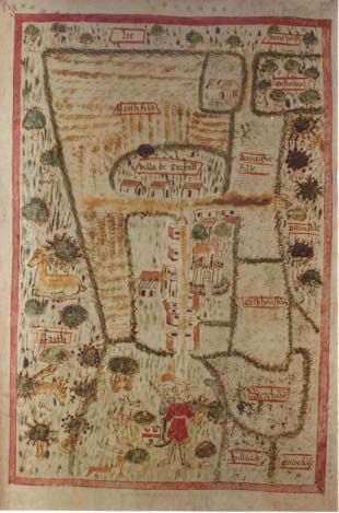
Map of Boarstall, from the Boarstall Cartulary
MAPS IN BUCKINGHAMSHIRE
The Centre for Buckinghamshire Studies holds a large and varied collection of maps of
Buckinghamshire, providing a visual record of the County from the unique Boarstall map of
the fifteenth century up to modern digital mapping from the Ordnance Survey. The Local
Studies Library holds more modern printed material primarily from the Ordnance Survey
whilst the Archives make historic maps available to researchers investigating the history of
their house, family or community. This leaflet aims to list some of the types of map you
might use in your research to help make the most of your visit to our office.Printed County Maps
Early maps showing the whole County can be works of art in themselves. (Colour
facsimiles of several are available for sale.) Some of the most useful County maps can be
found in the Archives, and include:
Jefferys’ map of Buckinghamshire, 1770
Bryant’s map of Buckinghamshire, 1825
A useful list is contained in Maps of Buckinghamshire 1574-1800 by Ursula Price. The
list includes printed maps of the County held in the Archives and elsewhere and has
helpful notes on early cartography. Similarly, Gordon Wyatt’s Maps of Bucks (Barracuda
Books, 1978) is fully illustrated with many examples.
Buckinghamshire by Kitchin and Jefferys, 1749 (County Library)
Historic maps
Maps have been produced for a wide variety of purposes - taxation, enclosure, estate
surveys – and are just as varied in the information and detail they contain. Some, such as
Tithe and Inclosure maps, are usually accompanied by explanatory text which lists the
owners of particular property at a given date. Such information is invaluable for
researching the history of a building or for filling in detail on your family tree.
Catalogues listing the majority of historic maps in the Archives are arranged alphabetically
by parish, so it is important to establish which parish covers the area you are interested in.
Staff will be pleased to advise you and there are numerous reference works available to
help if you are in any doubt. Although not all the following types of map exist for every
parish, some which you might find include:
♦ Tithe maps: produced for most parishes following the Tithe Commutation Act of 1836
to establish how much money property owners should pay in lieu of tithes to the
church. Maps are clearly marked to show buildings and may show names of fields.The text to accompany the map is usually referred to as an ‘Apportionment’ and will give details about the owners and occupiers of the land at that time. ♦ Inclosure maps: produced for those parishes which enclosed their open fields in the eighteenth and early nineteenth centuries. The maps are very carefully drawn to show the new allotments of land, which are also described in written ‘Inclosure Awards’. As in the Tithe Maps, numbered areas on each Inclosure map usually cross-reference to tables in the Award or on the map, which should tell you the names of the owner and the acreage and description of their property. ♦ Surveys of manors and estates: the Lord of a Manor or the owner of a particular estate may have commissioned a survey to be carried out to record the extent of his lands, or to show alterations to the estate. ♦ Highway Diversions: made by the order of Quarter Sessions, these maps show the diversion or stopping up of footpaths and highways in the nineteenth century. A ‘Visual Map Index’ is available in the search room which shows these routes superimposed on modern maps. Maps of Buckinghamshire parishes held in some other Record Offices or repositories are listed in the catalogue labelled ‘Bucks Maps’ and ‘Parishes General’ in the Archives search room. Valuation Maps: Revaluation of land values carried out by the Inland Revenue after 1910 produced coloured and annotated copies of Ordnance Survey maps (usually the 2nd edition 25” per mile maps). Using the maps in conjunction with accompanying volumes researchers can find out the names of the owners and occupiers of particular properties. The Archives has Valuation Maps and schedules to cover the majority of the county, listed in the catalogue, “’Domesday’ Survey (1910 Finance Act)”. Ordnance Survey (‘OS’) The history of the maps and surveys produced by the Ordnance Survey is described in numerous reference works. Particularly helpful is Richard Oliver’s, Ordnance Survey maps: a concise guide for historians (The Charles Close Society, London, 1993) which gives the dates, scales and scope of each survey. A full list of Centre for Buckinghamshire Studies holdings of Ordnance Survey maps and drawings can be found in the catalogue marked ‘Ordnance Survey’ in the Archives search room. The earliest OS maps held are the 1” and 2” drawings produced in the 1820s, followed by the ‘1st edition’ 6” and 25” per mile maps surveyed in the 1870s. The latter are complemented by OS Reference books, listed as D/X 809, found in the Ordnance Survey catalogue. Although OS maps do not give any information about the occupants of an area, the 6-inch maps include geographical features we would expect to find on modern maps, and 25-inch maps are detailed enough to show the existence of a building. Churches, pubs and
important houses are often named, although roads usually are not. The Centre holds
Bucks County sheets from the following editions of the 6 inch and 25 inch maps:
♦ 1870s-1880s (1st edition)
♦ 1898-1900 (2nd edition)
♦ 1919-1926
♦ 1930s (‘Provisional edition’)

Copies of large scale maps (1:1250 and 1:500) exist from 1878 and 1900 for some of the
larger towns: notably Aylesbury, Buckingham and High Wycombe. There are also later
‘National Grid’ OS maps that can be consulted, although there are no complete sets of
any one edition. Staff are always on hand to offer help and advice.

Digital mapping and aerial photographs

The entire County is covered by OS Digital mapping from 1995 (available to print out from
a computer in the Local Studies Library) and in the collection of aerial photographs
produced by the OS and RAF in 1947 and 1958. Place-name indexes and lists of
reference numbers to most aerial photographs are available in the ‘Photographs’
catalogue in the Archives search room.

Other published maps and guides

♦ Ordnance Survey 1 inch:mile map showing Local Authority boundaries in April 1934;
♦ 20th century street maps and guides of larger towns such as Aylesbury and High
  Wycombe;
♦ GOAD maps, published annually since the 1970s, naming all shops in the larger town
  centres;
♦ Hydro-geological maps of the County (only a few held);
♦ Definitive maps of the County, showing Rights of Way.
Reference Books and Guides to Maps of Buckinghamshire

All the following books are particularly useful sources of reference for the history and
location of maps and are available for reference in the Centre:

E M Elvey, A Hand-List of Buckinghamshire Estate Maps (1963) Buckinghamshire
Record Society
William Foot, Maps for Family History: A Guide to the records of the Tithe, Valuation
Office, and National Farm Surveys of England and Wales, 1836-1943, Public Record
Office Readers’ Guide No. 9 (1994) Public Record Office.*
Harley et al., Ordnance Survey maps
(A collection of papers on the history and coverage of the Ordnance Survey.)
Richard Oliver, Ordnance Survey maps: a concise guide for historians (1993) The
Charles Close Society, London.
Ursula Price, The maps of Buckinghamshire 1574-1800, I – III. (List of all published
maps of the County, with a bibliography on early cartography.)
W E Tate, A Hand-list of Buckinghamshire Enclosure Acts and Awards (1946) Bucks
County Council

*The originals of Tithe and 1910 Valuation maps are kept at the Public Record Office,
Kew, together with detailed ‘Field Books’ (PRO Ref: IR 58). Local Record Offices keep
working drafts or copies of the maps, so in some cases there may be slight differences
between them.

Obtaining copies of maps

Photocopies of Ordnance Survey maps out of copyright (over 50 years old) can be
obtained from the Centre, as can the small number of historic maps which would not be
damaged by the copying process. With the permission of the staff on duty, particularly
large, or rolled, maps can be traced or photographic copies can be made. In all cases,
staff will be pleased to advise you on the suitability and legality of making copies.

Facsimile maps for sale

• Buckinghamshire by John Speed, 1610 (1666 edition)             £2.50
• Buckinghamshire by J Blaeu, 1645                               £0.30
• Buckinghamshire by Jan Jansson, 1646 (1659 edition)            £2.50
• Buckinghamshire by R Blome, 1672                               £0.30
• Buckinghamshire by Thomas Dix, 1816                            £2.50
• Buckinghamshire in the 1760s and 1820s:                        £15.00
The County Maps of Jefferys and Bryant.
(Pub: Bucks Archaeological Society, 2000)
• Adapted map of the civil parishes of Buckinghamshire, 1925     £0.30
Useful addresses

Bedfordshire & Luton Archives and Record Service, County Hall, Cauldwell St.,
Bedford. Tel 01234 228833;
website: www.bedfordshire.gov.uk/archive

Hertfordshire Archives and Local Studies, County Hall, Hertford
Tel: 01992 555105; website: www.hertsdirect.org/heritage

Oxfordshire Record Office, St Luke’s Church, Temple Road, Cowley, Oxford OX4 2EX.
Tel: 01865 398200; website: www.oxfordshire.gov.uk/records

British Library Map Library, 96 Euston Road, London NW1 2DB
Tel: 020 7412 7702; website: www.bl.uk/collections/maps

The National Archives, Ruskin Avenue, Kew, Richmond, Surrey TW9 4DU.
Tel: 020 8876 3444; website: www.nationalarchives.gov.uk

Enquiries, Ordnance Survey, Romsey Road, Southampton SO16 4GU
website: www.ordsvy.gov.uk
CENTRE FOR BUCKINGHAMSHIRE STUDIES,
                 County Hall, Walton Street, Aylesbury, Bucks HP20 1UU
                          http://www.buckscc.gov.uk/archives

Opening hours and contact numbers
Archives:  Tues – Fri. 9.00-5.15; Sat. 9.00-3.45

Tel: (01296) 382587 to make an enquiry or reserve a seat.
e-mail: archives@buckscc.gov.uk

It is essential to reserve the large map table several days ahead of your visit to the Record
Office as many maps are large and need to be carefully handled.

Local Studies:      Mon - Wed & Fri: 9.00-5.30;
                    Thurs: 9.00-8.00; Sat: 9.00-4.00
Tel: (01296) 382250
e-mail: localstudies@buckscc.gov.uk
You can also read