Citywide Bicycle Improvements - City of Edmonds, WA
←
→
Page content transcription
If your browser does not render page correctly, please read the page content below
Citywide Bicycle
 Improvements

                   05.04.2021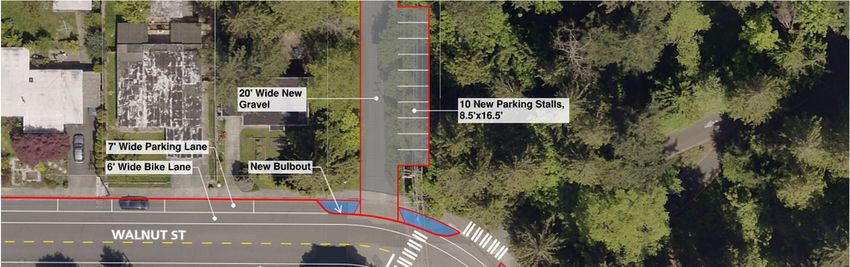
PR OJECT OVERVIEW: PR OJEC T SU MMARY

   Citywide project to add bike facilities on both sides of multiple area streets

   Funded by a $1.85 million Sound Transit Access grant

   Adds over 6 miles of bike facilities, bringing Citywide total to 17 miles – an increase
   of approximately 50%
   Project corridors:
      • 100th Ave W/9th Ave S:        244th St SW to Walnut St
      • Walnut St/Bowdoin Way:        9th Ave S to 84th Ave W
      • 228th St SW:                  78th Ave W to 80th Ave W
      • 80th Ave W:                   228th St SW to 220th St SW

                                                                                      2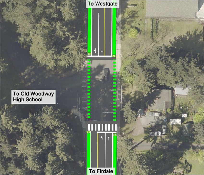
PROJECT OVERVIEW: MAP

                        3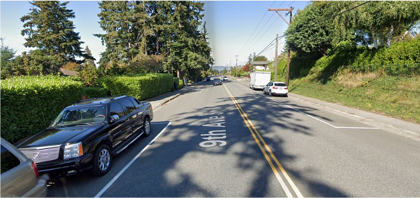
PROJECT OVERVIEW: TIMELINE

   Efforts to Date:
     • 2009-2019       Citywide Bike Plan/TIP/Sound Transit Grant Pursuit
     • July 2020       Public Hearing with City Council
     • Aug 2020        City Council approved Accepting Funds
     • Oct/Nov 2020    Blueline selected to assist City with Outreach and Design
     • Nov/Dec 2020    Survey, Parking Study, Traffic Analysis completed
     • Dec 2020        Listening Sessions held with the Community
     • Jan 2021        Preliminary Design Alternatives submitted to City for Review
     • February 2021   Public Outreach – Website, Survey, Zoom Meeting
     • May 2021        Project update to City Council
                                                                               4
PROJECT OVERVIEW: DESIGN TIMELINE

   Design Timeline:

                                    5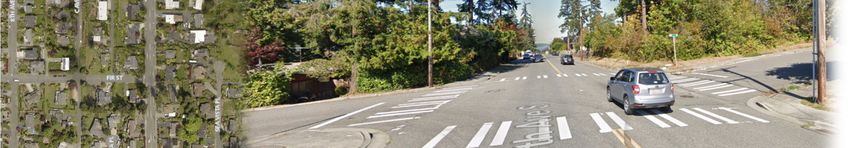
P R O J E C T O V E R V I E W : D ATA C O L L E C T I O N

     Efforts to Date:
         • Mapping/Field Survey
         • Parking Analysis
         • Traffic Analysis
         • Methodology for Alternatives
         • Preliminary Design
         • Public Involvement
            • Listening sessions
            • Public open house
            • Public survey
         • Alternatives Analysis                            6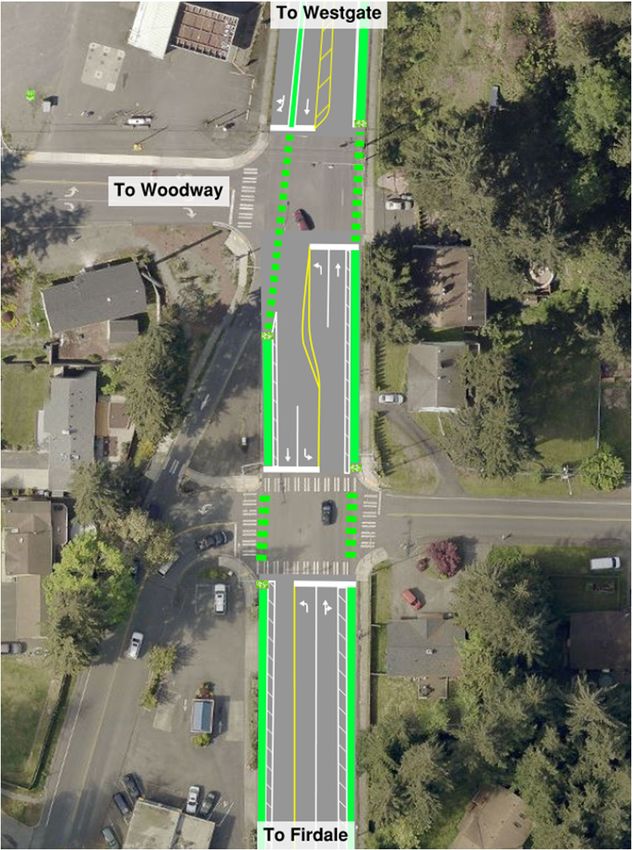
D ATA A N A LY S I S : PA R K I N G

     Data Collection
         • Data was collected over 3 days in
           Nov 2020
             • Wednesday
             • Friday
             • Sunday
         • Number of cars parked was
           recorded every hour from 7:00
           AM to 7:00 PM

                                               7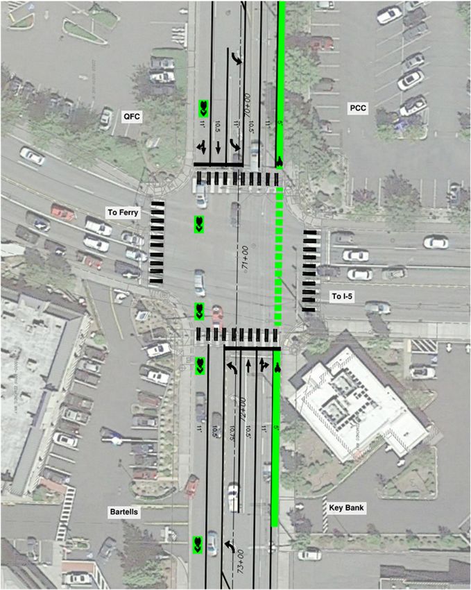
D ATA A N A LY S I S : PA R K I N G

     What does the data show?
         • Total of 518 spaces along project
             • 310 on Bowdoin Way/Walnut St
             • 208 on 9th Ave S
         • Average of 7% of stalls are used
           at any time throughout project
             • 481 parking stalls available
         • COVID correction factor
             • Use rate is similar to results
               collected in 2018, pre-COVID
             • No correction factor applied

                                                8
D ATA A N A LY S I S : T R A F F I C

     Data Collection                           • COVID-19 correction factor applied
                                                  • Based on change in volumes at 238th St
         • Road tube counts were                    SW and Hwy 99 between Aug 2019 and
           collected                                Aug 2020
             • Nov 17th, 2020 – Nov 23rd,         • Morning: 1.7x
               2020 (1 week)                      • Afternoon: 1.3x

         • Turning movement counts
           were collected
             • Wednesday Nov 18th, 2020
             • Turning movements counts
               indicate how traffic volumes
               are split at the intersection

                                                                                             9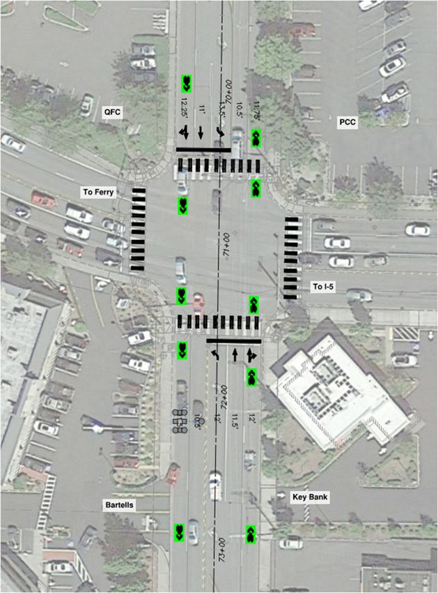
D ATA A N A LY S I S : T R A F F I C

     Dedicated Left Turn Lanes
         • Northbound and southbound left turn lanes will be added at
           9th Ave S and Pine St
             • Data collected in April 2021 during afternoon peak hours meet WSDOT
               Design Manual requirements to add lanes

                                                                                     10
PUBLIC OUTREACH
Efforts to Date:
• Listening sessions – 12/10/2020 • Public open house – 2/24/2021
• 90 residents who previously showed • 90 residents contacted by email to
interest in project were contacted attend
by email to attend, 21 attended • 150 door hangers distributed
• Message board announcing meeting
placed along project
• Postings in Edmonds Beacon, My
Edmonds New and City Facebook page
• 60 attendees
• Public survey – Closed on 3/1/2021
11PUBLIC OUTREACH
100th Ave W/9th Ave S Survey Results
Public Outreach Results 21%
24%
• Key Issues
9%
• Parking at Yost Park
• Improved pedestrian crossings
46%
throughout project areas
Alternative 1 Alternative 2A Alternative 2B Alternative 3
• Speeding vehicles
Bowdoin Way/Walnut St Survey Results
• Survey results
• 91 responses 32%
40%
• 100th Ave W/9th Ave S – Alternative 2A
• Bowdoin Way/Walnut St – Alternative 3
28%
Alternative 1 Alternative 2 Alternative 3
12P U B L I C O U T R E A C H : PA R K I N G AT Y O S T ( B O W D O I N WAY & 9 6 T H AV E W )
13
*for schematic representation onlyPUBLIC OUTREACH: PEDESTRIAN IMPROVEMENTS
Bowdoin Way & Pioneer Way/90th Ave W
• Flashing beacons
• Crosswalk markings
• Bulb-out(s)
14PUBLIC OUTREACH: PEDESTRIAN IMPROVEMENTS
9th Ave S & Pine St
• Flashing beacons
15PUBLIC OUTREACH: PEDESTRIAN IMPROVEMENTS
9th Ave S & 224th St SW/14th St SW
• Flashing beacons
• Crosswalk markings
• Bulb-out(s)
16PUBLIC OUTREACH: SPEEDING VEHICLES
• Bowdoin Way/Walnut St speed study
• Completed in March 2021
• 33mph for 85th percentile (current speed limit 30 mph)
• 9th Ave S/100th Ave W speed study
• Completed in 2017
• 36 mph for 85th percentile (current speed limit 30 mph)
• Vehicle speeds are expected to decrease
• Pedestrian bulb outs, flashing beacons and marked
crosswalks at select locations
• Lane width reduction shown to reduce driving speed
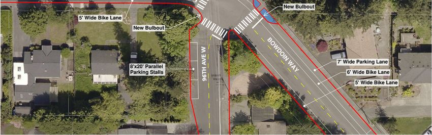
17B O W D O I N WAY / WA L N U T S T ( F R O M F I V E C O R N E R S T O 9 T H AV E S )
RECOMMENDED ALTERNATIVE
LOOKING EAST
• Geometry should contribute to traffic calming
• There is greater usage of parking on the north side of the street
• Street width allows dedicated bike lanes in both directions while retaining parking on one side of the street
• Sharrows are typically used in downhill sections; Bowdoin has both uphill and downhill sections making
sharrows less effective 189 T H AV E S / 1 0 0 T H AV E W ( N O R T H O F S R 1 0 4 )
RECOMMENDED ALTERNATIVE
LOOKING NORTH
• Public survey results indicated alternative 2A was most desired
• Homes on the west side tend to have shorter and steeper driveways, while homes on the east side tend to have more off-
street parking
• The current 4-lane configuration at Walnut St will remain as is to maintain PM peak hour Level of Service
• A greater number of cars park on the west side
19
• There are fewer driveways and streets on the west side, allowing for a greater number of parking stalls to be retained9 T H AV E S / 1 0 0 T H AV E W a n d 2 2 0 T H S T S W I N T E R S E C T I O N
RECOMMENDED CONFIGURATION
• This configuration minimizes lane offset that is currently
present at this intersection
• The northeast corner of the intersection will be widened in
order to provide bike lanes through the intersection along
the curb
• The northbound right turn lane has been removed; however
free right turn movements are not currently allowed at the
intersection
• Left turn movements on 9th Ave S/100th Ave W will get a
green arrow followed by a flashing yellow; This will improve
safety and level of service at this intersection
N
*green is for visual representation only of proposed bike lanes 20S R 1 0 4 a n d 1 0 0 T H AV E W I N T E R S E C T I O N
RECOMMENDED CONFIGURATION
• Provides a single northbound bike lane
• Addition of bike lane has little effect on wait time at the
intersection
• Provides two through lanes with a left turn lane (same as
existing configuration)
• Adds sharrows for southbound travel
• Balances the needs of bicyclists and vehicles
N
*green is for visual representation only of proposed bike lanes 21S R 1 0 4 a n d 1 0 0 T H AV E W I N T E R S E C T I O N
ALTERNATIVE 1 ALTERNATIVE 2
• Provides one bike lane in
northbound direction and
sharrow lane with bike ramps
in southbound direction
• Provides two through lanes in
each direction
• This configuration narrows
the lane width from 13’ to 11’
to provide two through lanes
• This configuration has very
little impact on wait time for
motorists
N
N
• Provides bike lane in each direction
• Significantly increases wait time for
motorists on all 4 legs *green is for visual representation only of proposed bike lanes
22S R 1 0 4 a n d 1 0 0 T H AV E W I N T E R S E C T I O N
ALTERNATIVE 3
• Provides sharrows to the outside lane for bike users who
are comfortable enough to pass through the intersection
with vehicle traffic and will add bike on/off ramps to the
sidewalk for a shared walkway
• In this configuration, it is expected that curb line
adjustments will need to be made in order to provide
enough room on sidewalks to allow pedestrian and bicycles
to comfortably share
• Bike users who are using the sidewalks will be asked to
move through the intersection in the same manner as a
pedestrian, sharing a narrow sidewalk
• This configuration has no impact on wait time for motorists
N
231 0 0 T H AV E W ( S O U T H O F S R 1 0 4 )
LOOKING NORTH
• Provides a bike lane in each direction
• Provides a center turn lane
241 0 0 T H AV E W a n d W O O D WAY C A M P U S I N T E R S E C T I O N
RECOMMENDED CONFIGURATION
• This configuration has the shortest southbound queue
length during extreme traffic conditions (school peak
period)
• This configuration provides a dedicated left turn lane for
school traffic from the northbound direction
• Relocation of crosswalk to south side of the intersection
N
*green is for visual representation only of proposed bike lanes
25F I R D A L E AV E ( 1 0 0 T H AV E W ) a n d 2 3 8 T H S T S W I N T E R S E C T I O N
RECOMMENDED CONFIGURATION
• This configuration has little to no lane offset and has a
relatively short queue length in the southbound right
turn lane
• This keeps the bike lane along the sidewalk through the
intersection in the northbound direction and following
the right turn lane in the southbound direction
N
*green is for visual representation only of proposed bike lanes 26F I R D A L E AV E ( S O U T H O F S R 1 0 4 )
LOOKING NORTH
• Provides a bike lane in each direction
• Provides a center turn lane
272 2 8 T H S T S W ( F R O M 8 0 T H AV E W T O 7 8 T H AV E W )
LOOKING WEST
• Roadway will be widened to add a bike lane in each direction
• Connects into existing bike lanes on 228th St SW near Hwy 99
• Wider bike lane will be provided on the western end of street where existing widths allow
288 0 T H AV E W ( F R O M 2 2 8 T H S T S W T O 2 2 0 T H S T S W )
LOOKING NORTH
• Sharrows will be added in each direction
• Work in Snohomish County
29PUBLIC RESOURCES
Public Contact Information:
• Email: bikelanes@edmondswa.org
• Project Contact: Ryan Hague, Capital
Projects Manager
• Phone: (425) 771-0220
Project Website:
• City Project Website
• Description, Status, Timeline
• Outreach Efforts
30QUESTIONS?
31You can also read