COLLABORATION OF DRONE AND INTERNET OF PUBLIC SAFETY THINGS IN SMART CITIES: AN OVERVIEW OF QOS AND NETWORK PERFORMANCE OPTIMIZATION - MDPI
←
→
Page content transcription
If your browser does not render page correctly, please read the page content below
drones
Article
Collaboration of Drone and Internet of Public Safety
Things in Smart Cities: An Overview of QoS and
Network Performance Optimization
Saeed H. Alsamhi 1,2, *, Ou Ma 3 , M. Samar Ansari 4       and Sachin Kumar Gupta 5
 1   School of Aerospace Engineering, Tsinghua University, Beijing 100084, China
 2   Department of Electonics Engineering, IBB University, Ibb, Yemen
 3   College of Engineering and Applied Science, University of Cincinnati, Cincinnati, OH 45220, USA;
     ou.ma@uc.edu
 4   Software Research Institute, Athlone Institute of Technology, Athlone, Ireland; mdsamar@gmail.com
 5   Department of ECE, SMVDU, Katra, (Jammu & Kashmir), India; sachin.rs.eee@itbhu.ac.in
 *   Correspondence: salsamhi@tsinghua.edu.cn; Tel.: +86-178-0123-9122

 Received: 5 November 2018; Accepted: 1 January 2019; Published: 27 January 2019

 Abstract: This paper studies the network performance of collaboration between the Internet of public
 safety things (IoPST) and drones. Drones play a vital role in delivering timely and essential wireless
 communication services for the recovery of services right after a disaster by increasing surge capacity
 for the purposes of public safety, exploring areas that are difficult to reach, and providing an area of
 rapid coverage and connectivity. To provide such critical facilities in the case of disasters and for the
 purposes of public safety, collaboration between drones and IoPST is able to support public safety
 requirements such as real-time analytics, real-time monitoring, and enhanced decision-making to
 help smart cities meet their public safety requirements. Therefore, the deployment of drone-based
 wireless communication can save people and ecosystems by helping public safety organizations face
 threats and manage crises in an efficient manner. The contribution of this work lies in improving the
 level of public safety in smart cities through collaborating between smart wearable devices and drone
 technology. Thus, the collaboration between drones and IoPST devices establishes a public safety
 network that shows satisfying results in terms of enhancing efficiency and information accuracy.

 Keywords: IoT; public safety network; drone; emergency communication; IoPST; SAR; smart cities

1. Introduction
      Recently, drones have become attractive for research and a variety of applications, because of
their flexibility and the possibility of use in a wide range of applications, such as the security, control,
monitoring, and exploration of terrestrial areas otherwise difficult to reach quickly. Furthermore,
this is transformative technology, enhancing how first responders can reach and carry out rescue
missions at the sites of natural disasters. In addition, it can provide support for delivering medical
supplies, as well as for emergency management cases such as forest firefighting, critical infrastructure
protection and inspection, coastal monitoring, and police augmentation, in addition to helping smart
cities meet their public safety requirements. The relationship between public safety and the Internet of
Things (IoT) was discussed in [1], while a taxonomy of the IoT-based smart city was provided in [2].
Applying IoT technologies to smart cities could lead to changes and improvements in the economy,
safety, management of public utilization, and transportation in smart cities.
      The most attractive application of drones is the collection of data from IoT using wearable devices
in smart cities or at events [3,4]. A drone can communicate with heterogeneous devices on the ground
that are unable to communicate over large areas and can send information to the intended destination

Drones 2019, 3, 13; doi:10.3390/drones3010013                                  www.mdpi.com/journal/drones
Drones2019,
Drones 2019,3,3,13
x FOR PEER REVIEW 22 of 18
19
the ground that are unable to communicate over large areas and can send information to the intended
in order to make
destination in ordera final
to makedecision
a finaland take action
decision and takein action
a timely
in afashion. The development
timely fashion. The developmentof suchof
communication technologies will lead to changes in how we communicate
such communication technologies will lead to changes in how we communicate with the vast number with the vast number
of
of things
things connected
connected to to the
the Internet.
Internet. However,
However, the the IoT
IoT refers
refers to
to the
the connections
connections among
among the the things
things
themselves. The concept of IoT refers to things that are not intelligent, and does not include
themselves. The concept of IoT refers to things that are not intelligent, and does not include artificial artificial
intelligence
intelligence(AI).
(AI).Furthermore,
Furthermore,the theInternet
Internetof ofrobotic
roboticthings
things(IoRT)
(IoRT)isisananintelligent
intelligentconcept
conceptthatthatgives
gives
the associated things the capacity for negotiation, reasoning, decision, and delegation
the associated things the capacity for negotiation, reasoning, decision, and delegation [5]. In contrast, [5]. In contrast,
the
theInternet
Internetof
ofpublic
publicsafety
safety things
things(IoPST)
(IoPST)refers
refersto
towearable
wearablethings
things for
for first
firstresponders
respondersthatthatare
areused
used
for
for public
public safety
safety and
and areareconnected
connectedvia viathe
theInternet,
Internet,such
suchas ascameras,
cameras,sensors,
sensors,and
anddrones.
drones. IoPST
IoPST
covers
covers different
different types
types ofof public
public service,
service, such
such as
as emergency
emergency response,
response, disaster
disaster relief,
relief, traffic
traffic control,
control,
crime
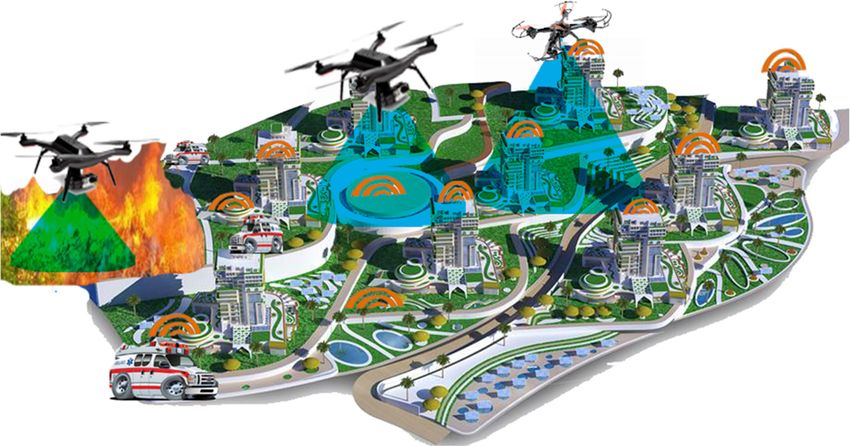
crime control, investigating accidents, smart event management, etc., as shown in Figure1.1.
control, investigating accidents, smart event management, etc., as shown in Figure
Figure1.1. An
Figure An illustration
illustrationof
ofthe
theIoPST
IoPSTconcept.
concept.
Wearable IoPST devices connect with each other in smart cities for the purposes of public
Wearable IoPST devices connect with each other in smart cities for the purposes of public safety,
safety, and allow first responders to share information with command posts and relevant parties.
and allow first responders to share information with command posts and relevant parties. These
These connected devices can help relief teams and police to identify when or where disasters or crime
connected devices can help relief teams and police to identify when or where disasters or crime have
have happened, as shown in Figure 2. On the basis of this, the police can successfully take decisions in
happened, as shown in Figure 2. On the basis of this, the police can successfully take decisions in
order to track down perpetrators.
order
Drones to track
2019, down
3, x FOR perpetrators.
PEER REVIEW 3 of 19
However, due to the limited transmission power of wearable devices, they are unable to send
data over long distances. Drone technology, however, is able to deliver services over a large
geographical zone in real time. The use of drone technology represents the cheapest and most
efficient way to monitor a criminal on the run, find a missing person, survey a disaster scene, etc.,
especially in time-critical situations. Therefore, the best features of the integration of drones and
IoPST are those that are supposed to achieve and provide maximum benefits, such as their
reprogrammability, good sensing capability, ability to interconnect and identify things, ubiquity,
communication capability, etc.
Figure2.2.An
Figure Anillustration
illustrationofofdevices
devicesconnecting
connectingtotoaadrone
dronefor
forthe
thepublic
publicsafety
safetynetwork.
network.
This article
However, duemainly focuses transmission
to the limited on the network performance
power of wearableofdevices,
drones and
theyIoPST. Furthermore,
are unable we
to send data
introduce
over the novelDrone
long distances. concept of collaboration
technology, between
however, is able drones andservices
to deliver IoPST in smart
over cities,
a large in order to
geographical
enhance
zone thetime.
in real network
Theperformance
use of droneand maintainrepresents
technology the QoS. Furthermore,
the cheapestwe anddiscuss drones in
most efficient public
way to
safety applications. With respect to public safety, we discuss the capability of drones and IoPST to
collect data in real time, track crimes, and guide police in finding crime locations, as well as guiding
Search and Rescue (SAR) teams effectively and efficiently, leading to improved orientation [6]. In this
case, the collaboration between drone technology and IoPST represents a key technology for
determining the location of lost people in SAR events in smart cities. Additionally, metrics for theDrones 2019, 3, 13 3 of 18
monitor a criminal on the run, find a missing person, survey a disaster scene, etc., especially in
time-critical situations. Therefore, the best features of the integration of drones and IoPST are those
that are supposed to achieve and provide maximum benefits, such as their reprogrammability, good
sensing capability, ability to interconnect and identify things, ubiquity, communication capability, etc.
This article mainly focuses on the network performance of drones and IoPST. Furthermore,
we introduce the novel concept of collaboration between drones and IoPST in smart cities, in order
to enhance the network performance and maintain the QoS. Furthermore, we discuss drones in
public safety applications. With respect to public safety, we discuss the capability of drones and
IoPST to collect data in real time, track crimes, and guide police in finding crime locations, as well as
guiding Search and Rescue (SAR) teams effectively and efficiently, leading to improved orientation [6].
In this case, the collaboration between drone technology and IoPST represents a key technology for
determining the location of lost people in SAR events in smart cities. Additionally, metrics for the
evaluation of the performance of drones and IoPST are considered, including path loss probabilities,
elevation angle, delay, and throughput. Our results show that the collaboration of drones and the
IoPST can significantly enhance the performance of emergency communication services by maintaining
high QoS, helping SAR teams to perform their duties efficiently, and reducing economic losses.
1.1. Related Work
Due to the occurrences of natural disasters, crime, and terrorist attacks, emergency services and
healthcare providers, in particular, must pay close attention to safety [7]. For this purpose, the wireless
communication linkage plays a vital role in assessing a damaged area, collecting data on supplies,
helping police to find the locations of incidents in smart cities, coordinating rescue team and relief
team activities, saving people’s lives, and accounting for missing people. To establish an efficient and
effective wireless communication network for delivering data in a disaster area spectrum width is
highly recommended [8,9]. However, terrestrial wireless communication technologies could be missing,
unavailable through congestion, or damaged [10]. The critical factors for emergency communication
network solutions and disaster recovery are rapid deployment, immediate availability, and reliability.
Therefore, space technologies represent the best solution for disaster recovery, public safety,
SAR, and emergency services [11]. Space technologies are used for collecting information needed
to protect human and reduce economic losses. In the aftermath of a disaster, a satellite is a reliable
communication solution [12], but the weakness is a time delay and launching cost. Therefore, using
an aerial platform can be a better solution, because it has the merits of both space and terrestrial
wireless communication systems. Mohorcic et al. [13] argued the use of aerial platforms for disaster and
emergency situations and also showed the significance of rescue teams during the disaster. The ability
of an aerial platform to deliver communication services such as E911 to facilitate SAR operations
is discussed in [14]. The advantages of aerial platforms are the capability and stable coverage area,
survivability [15], mitigated interference that occurs in the wireless communication [16], and ability to
manage traffic [17]. They offer a valuable alternative to support emergency communications after a
disaster [18]. Disaster prediction coverage for mitigation of disaster impact a from low-altitude platform
(LAP) is discussed in [19].
Drones belong to the LAP family [20,21], and are considered to be space robots. The significant
advantages of drones are deployment cost, line of sight (LoS), low propagation delay, rapid deployment,
fixed station, and use in disasters. The propagation models, mobility, and positioning of drones for
a communication network are discussed in [22]. Drones are attractive for emergency communication
because of the possibility of rapid deployment and users operating them from their existing mobile
handsets in disaster zones. Therefore, drones represent the best solution for disaster recovery and
emergency services because they can be used to support relief and rescue teams in performing their
tasks efficiently. Drones play a vital role in connected devices in smart cities. Hence, the authors of [23]
reviewed the various aspect of drones related to privacy, cyber security, and public safety in smart cities.Drones 2019, 3, 13 4 of 18
IoT devices, robots, and humans can communicate as a cooperative. In particular, when flying
drones are used, they can support the connectivity of existing terrestrial wireless networks such as
cellular and broadband networks. Compared to terrestrial base stations, the advantage of using drones
as flying base stations is their ability to provide on-the-fly communications and to establish a LoS
communication links to ground users. However, the coverage area for the deployment of drone base
station was considered for minimizing energy cost, improving the coverage radius and optimal altitude
of drones [24]. Indeed, another important application of drones is in IoT scenarios [25,26], because
devices often have small transmission power and may not be able to communicate over a long range.
Sharma et al. [27] summarized the various cooperation approaches for the formation of drones. Also,
Sharma et al. [28] developed a scenario for traffic management and cooperation of drones and nodes on
the ground to provide continuous data transfers and network stabilization by using adhoc technology.
The target applications and technological implications of IoT-aided robotics were discussed [29].
Furthermore, Dutta et al. [30] addressed the network security enhancement of IoT-aided robotics in a
complex environment. In addition to the work of the authors in [30], the authors of [31,32] reviewed
the convergence in terms of network protocols, architectures, and embedded software for IoT robotics
for smart cities. The interaction of robotic and IoT devices was investigated [33,34]. Therefore, AI,
robots, and IoT will provide the next generation of IoT applications [35]. Moreover, renewable energy
harvesting was discussed for the energy Internet of drone communication and networks [36]. Therefore,
drone technology and information and communication technologies pay a vital role in smart cities’
reduction of resource consumption and costs. Greening information and communication technologies
enabled the green IoT [37] by reducing energy consumption, pollution, and hazardous emissions in
smart cities. Most of the challenges regarding energy efficiency, interference, and communication
networks are discussed in depth [38–42], along with intelligent techniques for processing data [43,44].
Furthermore, the authors of [45] explored the potential usefulness of the IoT to enhance public
safety and discussed the challenges and opportunities of using the IoT to support public safety
networks and SAR. The hybrid network architecture for public safety broadband communication was
discussed in [46], in which the stationary base station supports heavy traffic after an incident. However,
LTE network architecture towards 5G in order to support emerging public safety was discussed
in [47]. The authors of [48] analyzed how the deployment of the drone as a base station could deliver
communication services to a particular area. Furthermore, the coexistence between heterogonous
devices and drones was discussed. The fundamental operation and techniques were introduced for
enhancing the efficiency and accuracy of public safety network using IoT technologies. Moreover,
the authors of [49] reviewed the techniques and the availability of IoT for disaster management.
Reina et al. [50] outlined the disaster management and the importance of using IoT and big data.
The study focused on the use of drones as 0th responders to deliver communication service to victims
in a disaster. The main idea of the 0th responder was to arrive at the disaster area before the first
responders. The work was divided into two parts, the collection of data and the use of local searching
to find the optimal position in which the drone could deliver communication services to the victims.
Furthermore, the work in [50] was supported by [51], in which the position of the 0th responder was
considered for delivering communication services to victims in disaster areas. However, keeping
a connectivity link between the 0th responder and other responders was not discussed. Therefore,
Alsamhi et al. [52] developed an artificial neural network to predict signal strength between the
drone and wearable IoT devices or other responders on the ground to keep up connectivity for
delivering services. The collaboration of drones and IoT plays a significant role in public safety.
The proposed network architecture, that is, the integration of drones, IoT and smart wearable devices,
offers numerous services like supporting disaster relief team to save human lives, long-distance
communication, greening communication, etc. To the best of our knowledge, no study has been done
to evaluate the collaboration of drone and IoPST performance network. The summary of related work
is shown in Table 1.Drones 2019, 3, 13 5 of 18
Table 1. Summary of the related work.
Smart Public
Ref. Highlighted SAR IoT Drone Focus
Cities Safety
◦ Use of drones as 0th
responders to deliver
Importance of using IoT communication service
and big data for disaster √ √ √ √ to victims
Reina et al. [50] (2018)
management and public ◦ Collection of data and the use
safety of local searching to find the
optimal position
◦ Co-existence between drone
Drone deployment to and D2D
Mozaffari et al. [48] provide wireless √ √ √ √ communication network
(2016) communications services ◦ The tradeoff between coverage
to a given area and delay
◦ Reviewed the enabled
Zanella et al. [32] √ √ protocols, technologies, and
IoT for smart cities architecture of IoT for
(2014)
smart cities.
◦ Reviewed the enabling
Green IoT for healthy √ √ √ √ technologies to reduce
Alsamhi et al. [37]
environment and in pollution, energy consumption,
(2018)
smart cities and resource usage.
◦ Increased global connectedness
to be offered by IoT
Msadaa et al. [45] IoT in Support of Public √ √ √ ◦ Save lives and the
- - environment by helping PS
(2016) Safety Networks
organizations face threats and
manage crises efficiently
◦ Source IoT platforms for
Mehmood et al. [2] Devise a taxonomy of the √ √ realizing smart
◦ ◦ ◦ ◦
(2017) IoT-based smart city city applications
Average traffic of public √ √ ◦ Reduction of the required
Chen et al. [46] (2016) safety networks ◦ ◦ ◦ ◦ ◦ number of base stations
architecture
LTE network architecture √ √ ◦ Supporting network mobility
Favraud et al. [47]
towards 5G in order to ◦ ◦ ◦ ◦ ◦ ◦ Less expensive
(2016)
support emerging PS
Importance of
incorporating the drones ◦ Enable high data rate
√ √ √ ◦ Improving the 5G
Naqviet al. [53] (2018) in the heterogeneous
network for capacity and energy efficiency
coverage extension
◦ Effective and efficient data
dissemination represents the
key technology of processing
The communication public safety.
technologies that enable √ √ ◦ Collected data help to build a
Kolios et al. [6] (2016) better picture of the situation
data dissemination in
public safety networks ◦ Data distributed to individuals
can reassure them of the
measures taken to alleviate
the risks.
Mohamed et al. [4] Integrating drones in √ √ √ √ ◦ cost-effective services
(2018) smart cities ◦ reduce resource consumptionDrones 2019, 3, 13 6 of 18
Table 1. Cont.
Smart Public
Ref. Highlighted SAR IoT Drone Focus
Cities Safety
◦ 0th responders are to arrive at
the disaster scenario before the
Drone as 0th responders √ √ √ √ 1st responder
Reina et al. [51] (2018)
and its best position ◦ Finding the best position of
0th responders
Signal strength between √ √ √ ◦ Predict the accurate
Alsamhi et al. [52]
drone and IoT device in signal strength
(2018)
smart cities
◦ The collaboration of advanced
Collaboration of drone √ √ √ √ √ technologies for public safety
Alsamhi et al.
and Internet of public ◦ Efficient connectivity services
[The proposed work]
safety things ◦ Enhancing QoS
2. Public Safety Network
A public safety network between victims and first responders is vital for search and rescue
operations. Capable and fast emergency communication is needed for an effective public safety
communication network. During public safety communication, efficient communication technology
will save people’s lives and improve connectivity among the SAR teams. WiMAX, WiFi, ad hoc,
and long-term evolution (LTE) are the potential broadband communication types dedicated for
public safety networks. However, these technologies are useless if a disaster occurs. Therefore,
space technology is the best solution for public safety and disaster recovery when terrestrial
communication systems are destroyed [54]. In this regard, drones play a vital role in public safety and
disaster recovery/emergency services because they are able to reach areas human rescue teams cannot
reach immediately and provide a critical first response.
2.1. Drones for Public Safety
Drones can fly autonomously in the sky and are associated with different applications in
civilian tasks such as transportation, communication, agriculture, disaster mitigation, emergency
response, smart things, and environmental preservation. They are a promising technology because of
their rapid and easy deployment, ability to dynamically change location in an emergency situation,
quick reconfiguration, and flexible technology. Furthermore, they can provide effective communication
for a public safety network, as shown in Figure 2. Moreover, drones can move around to provide large
disaster coverage area faster, and achieve ubiquitous connectivity within a minimum time in a public
safety network.
Emergency communications are the most important and specialized field for giving high value
to people’s lives. During an earthquake or tsunami, there is no ground transportation, so drones
can provide and maintain wireless emergency communication services during and after the disaster.
Therefore, the SAR team can easily perform their tasks in a sequential manner. When a drone reaches
the desired altitude, the affected area will be surveyed via a digital video camera. Then, collected
images will be sent to a ground station for monitoring the area of operation and coordinating SAR
teams with first responders’ arrival. The authors of [40] introduced a multi-drone network architecture
and demonstrated the network benefits in SAR and disaster assistance.
Drones are all about the payload, so the type of event determines what equipment should be in
the payload. Therefore, the most common drones used for public safety are the Dà-Jiāng Innovations
(DJI) Inspire and DJI Phantom, as shown in Figure 3; both are from the DJI family. The DJI Phantom
is easy to acquire, land and take off, flexible in terms of the camera tilting, and able to fly around
objects, but even experienced pilots can get into tough spots. The features and advantages of the DJI
drone are explained in [23]. Furthermore, DJI drones provide better SAR [55], so they can be usedarchitecture and demonstrated the network benefits in SAR and disaster assistance.
Drones are all about the payload, so the type of event determines what equipment should be in
the payload. Therefore, the most common drones used for public safety are the Dà-Jiāng Innovations
(DJI) Inspire and DJI Phantom, as shown in Figure 3; both are from the DJI family. The DJI Phantom
is easy
Drones to 3,acquire,
2019, 13 land and take off, flexible in terms of the camera tilting, and able to fly around 7 of 18
objects, but even experienced pilots can get into tough spots. The features and advantages of the DJI
drone are explained in [23]. Furthermore, DJI drones provide better SAR [55], so they can be used for
for
all all
sortssorts
of of activities
activities suchasasenvironmental
such environmentalmonitoring,
monitoring,disaster
disastermanagement,
management, mapping,
mapping, andand 3D
3D
modeling.
modeling. During the launch of a DJI drone, it starts looking for interference, and when found itit will
During the launch of a DJI drone, it starts looking for interference, and when found will
try
try to
to localize
localize thethe interferer.
interferer. It
It will
will also
also change
change the
the flight
flight plan
plan to get the
to get the next
next meaningful
meaningful measurement
measurement
point,
point, reducing the flight time. The DJI drones are efficient at capturing imagery of sufficient quality
reducing the flight time. The DJI drones are efficient at capturing imagery of sufficient quality
for the 3D mapping required for accident reconstruction and crime scene visualization
for the 3D mapping required for accident reconstruction and crime scene visualization in smart cities. in smart cities.
Figure 3.
Figure 3. Public safety
safety DJI
DJI drone
drone [23].
[23].
Recently,
Recently, aa lot
lot of
of studies
studies have
have investigated
investigated various
various design
design challenges
challenges such
such as
as 3D
3D deployment,
deployment,
energy
energy efficiency, and time flight constraint. The optimal 3D deployment of drones for extending the
efficiency, and time flight constraint. The optimal 3D deployment of drones for extending the
coverage area and
coverage area and enhancing
enhancingthe theQoS
QoSisisdiscussed
discussedinin [56].
[56]. TheThe idea
idea is supported
is supported by aby a study
study [57] [57]
that
that discusses
discusses the 3Dthedeployment
3D deployment of a multiple
of a multiple drone
drone base base to
station station to maximize
maximize the coverage
the coverage area and
area and maintain the link quality between drones and the ground station by
maintain the link quality between drones and the ground station by using the practical swarmusing the practical
swarm optimization
optimization technique. technique. Furthermore,
Furthermore, drones’ drones’ 3D deployment
3D deployment represents
represents a key technology
a key technology that can
that can
assess assess
drones to drones
deliver to deliverservices
network networkfor services for public
public safety safety management.
and disaster and disaster Therefore,
management. the
Therefore, the authors of [58] proposed a practical swarm optimization technique to enable the
drones’ 3D deployment to provide a large coverage area, maintain connectivity, and satisfy users’
QoS requirements and drone capacity. Also, 3D deployment for swarm drones was introduced for
maximizing the available lifetime of drones and the total throughput of all users [59].
2.1.1. Coverage Area
The optimal placement of drones for public safety communications to enhance the coverage
performance is discussed in [60]. The coverage can be extended with a number of drones, as shown
in Figure 4. These drones can connect with each other and with first responders over an emergency
or disaster area for delivering services accordingly. A drone lifts a flying platform by incorporating
communication technologies such as ad hoc, WiFi, WiMAX, or LTE equipment to provide efficient
communication services. A disaster generally destroys all of the communication and electric supply
infrastructure. For some people, the availability of electricity means the difference between life and
death. Electric power is required for lighting medical aid stations, ventilation, and delivering water
to people in shelters, as shown in Figure 5. The figure illustrates the architecture power beaming
transport from a drone. Therefore, power is beamed from a drone to the rescue and relief team receiver
devices over the disaster area.
During an earthquake, power may go out immediately. During a tsunami, the water level remains
high for several hours, and many people are swept away several kilometers out to sea, creating an
urgent need for rescue and relief over the sea. Therefore, the emergency communication system
must take into consideration that no support can come via ground transportation. Hence, power
transmission technologies must have a time-varying electromagnetic field [61]. Wireless transmission
power is electric power that transmits from the power source to destination machines without discrete
human-made conductors [62]. Wireless power transmission is useful in case of hazards. A transmitter
machine connected to the source of power, then using an electromagnetic field for power transmissionin Figure 4. These drones can connect with each other and with first responders over an emergency
or
or disaster
disaster area
area for
for delivering
delivering services
services accordingly.
accordingly. A A drone
drone lifts
lifts aa flying
flying platform
platform by
by incorporating
incorporating
communication
communication technologies such as ad hoc, WiFi, WiMAX, or LTE equipment to provide
technologies such as ad hoc, WiFi, WiMAX, or LTE equipment to provide efficient
efficient
communication
communication services.
services. AA disaster
disaster generally
generally destroys
destroys all
all of
of the
the communication
communication and and electric
electric supply
supply
infrastructure.
infrastructure. For some people, the availability of electricity means the difference between life and
For some people, the availability of electricity means the difference between life and
Drones 2019, 3, 13 8 of 18
death.
death. Electric
Electric power
power isis required
required for
for lighting
lighting medical
medical aid
aid stations,
stations, ventilation,
ventilation, and
and delivering
delivering water
water
to
to people
people in in shelters,
shelters, as
as shown
shown inin Figure
Figure 5.5. The
The figure
figure illustrates
illustrates the
the architecture
architecture power
power beaming
beaming
transport
transport from a drone.
from a drone.
across an intervening Therefore,
Therefore,
space power
to one orpower is beamed
is beamed
more receivers, from
from
will a drone
a drone
finally to the rescue
to the rescue
be converted and
back toand relief team
reliefpower
electric team
receiver
receiver devices
devices
for utilization over the disaster area.
over the disaster area.
[61].
Figure
Figure 4. An extension of the public safety network by using a team of
of drones.
Figure 4.
4. An
An extension
extension of
of the
the public
public safety
safety network
network by
by using
using aa team
team of drones.
drones.
Figure
Figure 5.
Figure 5. Drone
5. Drone for
Drone for IoPST
for IoPST in
IoPST in emergency
in emergency services
emergency services and
services and disaster
and disaster recovery.
disaster recovery.
recovery.
2.1.2.During
Probabilityearthquake,
of Line of Sight
During anan earthquake, power power maymay go go out
out immediately.
immediately. During
During aa tsunami,
tsunami, thethe water
water level
level
remains
remains high
The high for
line for several
of sight
several hours,
means
hours, and
theand many
straight people
many path are
from
people swept
arethe
swept away
signal
away several
source kilometers
to akilometers
several out
out to
targeted locationto sea,
in
sea,
creating an
an urgent
three-dimensional
creating need
need for
urgent space. rescue
rescue and
and relief
Environmental
for over
impacts
relief the
overand sea.
sea. Therefore,
the elevation angle the
Therefore, playemergency
the a vital rolecommunication
emergency in determining
communication
system
system must
propagation take
take into
mustfeatures consideration
from
into that
a drone to IoT
consideration no
no support
thatdevices on the
support can come
come via
ground.
can via ground
For the transportation.
design
ground Hence,
of a communication
transportation. Hence,
power
power transmission
system,transmission
the transmitted technologies must
signal should
technologies must have
be have a
receivedtime-varying
with sufficient
a time-varying electromagnetic field
signal strengthfield
electromagnetic [61].
without Wireless
[61].distortion.
Wireless
transmission
The power
probability
transmission power is
is electric
distortion forpower
electric that
that transmits
transmits from
LoS corresponding
power the
the power
to each
from source
elevation
power to
angle
source to destination machines
in each propagation
destination machines
environment was calculated in [63]. The LoS probability from a smart drone to IoT devices on
the ground will be used to estimate the coverage area and capacity, which allow IoT devices in smart
environments to move around and gather data in the drone coverage area.
The primary application of the channel analyzer is the ability to optimize the performance of the
smart drone rapidly. The altitude of a drone plays a vital role in determining the coverage area and
received signal strength on the ground. Increasing the height of a drone will lead to enhancing the
coverage area. Therefore, it will deliver services to a larger area and many users and devices will get
services. Finding an optimized altitude is significant for maximizing the probability of coverage and
small loss. If the height of the drone is h and the radius of the coverage area is R, then the distance
between the drone and the ground receiver d is given in Equation (1):
q
d= R2 + h2 , (1)Drones 2019, 3, 13 9 of 18
where the elevation angle θ of the drone concerning the user on the ground depends on the height of
the drone and the coverage radius. This is given in Equation (2):
h
θ = tan−1 ( ). (2)
R
The path loss depends on the carrier frequency fc , the distance between drone and receiver on the
ground d, and light speed c. The path loss is given by [64], as shown in Equation (3):
(
20 log(4πfc d/c) + εlos Los
PL(dB) = , (3)
20 log(4πfc d/c) + εnlos NLoS
where εlos and εnlos are the average additional losses to the free space loss. One of the most significant
advantages of drone communication is LoS. Therefore, the LoS probability is crucial to correctly
predicting signal attenuation among drones, IoT devices, robots or any objects on the ground.
Prediction of accurate LoS probability determination helps to obtain more realistic path loss models.
The elevation angle is the most critical parameter for predicting LoS probability. Plotting the probability
of LoS depends on the parameter values of the environmental variables α, β, γ, which are given
different values in different areas based on [65]. The investigation of the probability of LoS condition
based on [65] and the final formula of LoS probability is:
(n+0.5)(ht−hr) 2
m [ht− m+1
]
−
Plos = ∏ [1 − e 2γ2 ] (4)
n=0
p
m=r αβ − 1 (5)
r = h tan(θ ) , (6)
where ht and hr represent the height of the receiver and transmitter, respectively; r is the ground
distance between the receiver and transmitter. However, plotting the resulting base on Equation (4)
will smooth out because of the significant value of ht. Therefore, Plos is considered to be calculated
based on θ and environmental parameter impacts [63]. Holis et al. [63] directly suggested Plos as:
θ − C3 C5
Plos = C1 − (C1 − C2)/(1 + ( ) , (7)
C4
where C1 . . . C5 are environments parameters are given in [63]. However, Hourani et al. [65,66]
expressed the Plos by sigmoid term concerning elevation angle θ as:
1
Plos = , (8)
1 + ae−b(θ−a)
where a and b represent the S-curve parameters. Here, the Plos is easy to calculate and analytically flexible.
2.2. IoT Devices for Public Safety
IoT devices can play a vital role in enhancing the performance of a public safety network in
terms of accuracy, efficiency, and predictability [45]. Furthermore, IoT devices have to analyze,
aggregate information, and transmit without human intervention. This ensures the accuracy of
received information and enhances the ability to anticipate crimes and other incidents. It is helpful to
predict where crimes and natural disasters are more likely to occur. Figure 6 shows the classification of
IoT for disaster management, which includes natural, manmade, service orientation, and post-disaster.
Natural disasters include floods, earthquakes, landslides, etc.; however, the post-disaster focus is onlyIoT devices can play a vital role in enhancing the performance of a public safety network in
terms of accuracy, efficiency, and predictability [45]. Furthermore, IoT devices have to analyze,
aggregate information, and transmit without human intervention. This ensures the accuracy of
received information and enhances the ability to anticipate crimes and other incidents. It is helpful to
predict
Drones where
2019, 3, 13 crimes and natural disasters are more likely to occur. Figure 6 shows the classification
10 of 18
of IoT for disaster management, which includes natural, manmade, service orientation, and post-
disaster. Natural disasters include floods, earthquakes, landslides, etc.; however, the post-disaster
on saving
focus victims
is only in their
on saving locations.
victims On locations.
in their the other hand,
On theIoT for hand,
other service-oriented disaster management
IoT for service-oriented disaster
has been discussed in [67–69].
management has been discussed in [67–69].
Terrorist
Man Made Industrial
IoT for Disaster Managment
Service Attack and Collision
Orientation
Flood
Post- disaster
Earthquake
Natural
Volcanic
Landslide
Figure 6. IoT-based
Figure 6. IoT-based disaster
disaster management
management classification.
classification.
2.3. Drones and IoT for Public Safety
2.3. Drones and IoT for Public Safety
Recently, drones have played a vital role in developing the next generation of wireless network
Recently, drones have played a vital role in developing the next generation of wireless network
and IoT. Therefore, they have attracted the attention of people who want to quickly develop drone
and IoT. Therefore, they have attracted the attention of people who want to quickly develop drone
applications that serve society, industry, government, and the environment. Furthermore, drones have
applications that serve society, industry, government, and the environment. Furthermore, drones
a branch of sensors that can get real-time information everywhere they fly. Recently, a lot of connected
have a branch of sensors that can get real-time information everywhere they fly. Recently, a lot of
sensors are being efficiently replaced by one drone that has the most essential features such as ease
connected sensors are being efficiently replaced by one drone that has the most essential features
of deployment, flexible payload, programmability, and the ability to measure anything at any time
such as ease of deployment, flexible payload, programmability, and the ability to measure anything
anywhere. Drones can enable communication services while wireless communication networks are
at any time anywhere. Drones can enable communication services while wireless communication
damaged during disaster [19]. They can also be used to gather information at a particular place and
networks are damaged during disaster [19]. They can also be used to gather information at a
send the information to a control center in real time to aid with making the right decisions.
particular place and send the information to a control center in real time to aid with making the right
Drones offer several advantages over IoT stationary devices such as: they can be used for lengthy
decisions.
periods at any altitude, they have better resolution image quality, are low cost, have a rapid response,
Drones offer several advantages over IoT stationary devices such as: they can be used for lengthy
are capable of flying in any conditions, and are able to get closer to areas of interest. They represent
periods at any altitude, they have better resolution image quality, are low cost, have a rapid response,
a useful emerging technique for delivering wireless service to users or IoT devices on the ground,
are capable of flying in any conditions, and are able to get closer to areas of interest. They represent
and have been investigated for their large coverage area and reduced power consumption [70].
3. Collaboration of Drones and Internet of Public Safety Things
IoPST wearable devices (i.e., sensors, cameras, other sensors) are ideal for first responders.
The combination of a wireless sensor network and IoT is developed for a safety management system
for tower crane groups [71]. Furthermore, wearable IoT devices present high potential for monitoring
rescue and research teams during the disaster and communicating with the devices in the payload of
the drone, as shown in Figure 2. The wearable IoPST devices connect over smart cities or a disaster
area to allow first responders to share information with command posts and relevant parties, as shown
in Figure 7. The drones play a vital role in collecting data from different devices during a disaster or
scheduled event in smart cities. These connected devices help police and SAR teams identify when or
where a crime or disaster happened. Therefore, police or SAR teams can make the right decisions and
track down perpetrators. Here, drone technology is capable of carrying these devices and delivering
services over a large coverage area, whereas connected devices are unable to send data a long distance
due to their limited transmission power. The operational protocols of drones enable them to impact
directly on the SAR team performance. SAR represents the most promising drone applications forthe drone, as shown in Figure 2. The wearable IoPST devices connect over smart cities or a disaster
area to allow first responders to share information with command posts and relevant parties, as
shown in Figure 7. The drones play a vital role in collecting data from different devices during a
disaster or scheduled event in smart cities. These connected devices help police and SAR teams
identify when or where a crime or disaster happened. Therefore, police or SAR teams can make the
Drones 2019, 3, 13 and track down perpetrators. Here, drone technology is capable of carrying these
right decisions 11 of 18
devices and delivering services over a large coverage area, whereas connected devices are unable to
send data a long distance due to their limited transmission power. The operational protocols of
public
drones safety.
enable SAR
themprocessing can vary
to impact directly ontremendously
the SAR teambased on weather,
performance. SAR environment,
represents the the
mostexperience
of the searchers, and the location of the lost people.
promising drone applications for public safety. SAR processing can vary tremendously based on
Drones
weather, will sendthe
environment, outexperience
the collected
of thedata in realand
searchers, time.
theFurthermore,
location of thethey provide tactical assistance
lost people.
Drones public
to increase will send out the
safety collected
and officerdata in real
safety in time.
termsFurthermore,
of situationaltheyawareness.
provide tactical assistance
Drones not only offer
to increase public
immediate care tosafety
thoseand officer safety
impacted in terms of situational
by a crime/disaster but canawareness.
also gather Drones
data not
thatonly
helpoffer
cities rebuild
immediate care to those impacted by a crime/disaster but can also gather data that
after a disaster occurs. Furthermore, decision-making about public safety will be taken based on help cities rebuild
after a disaster occurs. Furthermore, decision-making about public safety will be taken based on
massive quantities of revel vent data collected by various devices connected to drones that are able
massive quantities of revel vent data collected by various devices connected to drones that are able
to send data out in real time. Real-time data allow public safety authorities to quickly take action to
to send data out in real time. Real-time data allow public safety authorities to quickly take action to
keep peoplesafe.
keep people safe.The
The authorities
authorities willwill
taketake real-time
real-time analytics
analytics based
based on on real-time
real-time data from
data received received from
aa drone. Real-time analytics will help resolve public safety problems in time
drone. Real-time analytics will help resolve public safety problems in time to help people before to help people before
events/crimes occur.
events/crimes occur. Therefore,
Therefore, the combination
the combination of drones
of drones and will
and IoPST IoPST will contribute
contribute to many tasks
to many tasks
and applications,asas
and applications, shown
shown in Figure
in Figure 8. The8. The applications
applications include include police infrastructure,
police infrastructure, surveillance,
surveillance,
equipment tracking,
equipment tracking, andandemergency
emergency services.
services.
Figure 7. An7.illustration
Figure
Drones 2019, 3, x FOR PEER REVIEW of drones
An illustration and IoPST.
of drones and IoPST. 12 of 19
Figure
Figure 8. IoPSTapplication
8. IoPST application and
anddevice
deviceproliferation.
proliferation.
4. Results and Discussion
The most important aspect of drones and the IoPST is the ability of these two technologies to
form an effective and efficient communication network for public safety. Drones offer many benefits
such as rapid deployment, LoS, reprogrammability, etc. Therefore, the network performance of the
collaboration of drones and IoPST before, during, and after a disaster should improve greatly.Drones 2019, 3, 13 12 of 18
4. Results and Discussion
The most important aspect of drones and the IoPST is the ability of these two technologies to
form an effective and efficient communication network for public safety. Drones offer many benefits
such as rapid deployment, LoS, reprogrammability, etc. Therefore, the network performance of the
collaboration of drones and IoPST before, during, and after a disaster should improve greatly.
The simulation network is made using OPNET 14.5. The scenario consists of three drones and
three SAR responders. A mobile ad hoc network (MANET) is proposed to connect the drones and
responders to perform tasks efficiently. Also, the AODV routing protocol is considered for unicast
and multicast routing services. Furthermore, the simulation time is 500 s. One drone is moving
around closer to the events, as shown in Figure 2. This drone will capture an image of the event and
share it with other drones and SAR on the ground for performing relevant actions according to the
available data given by drone-2. Drone-1 and drone-3 are used to guide and deliver the supplies
required by the SAR or people in a particular area. SAR-1, SAR-2, and SAR-3 are performing their
duty by the guiding of drones and their wearable devices help drones to identify the location where
they are needed. QoS parameters such as delay and throughput are considered for measuring the
performance of the drones and SARs in particular events. The throughput and delay are measured
for each device
Drones 2019, 3, connected in a network, for testing joint performance during a disaster. Furthermore,
x FOR PEER REVIEW 13 of 19
the loss probabilities are calculated and simulated by a Matlab code.
The throughput increased with Table
the2.increase
Throughput for different
of the packet nodes.
size through all number of nodes. Thus,
the difference between each number
Object Minimumof nodes also increases
Maximum Averageduring
Stdthe
Devincreasing packet size in
the different time, as shown in
SAR-1 Figure 9.
0 Throughput
7908.8 decreases
4016.3 when1368.3 wireless node increases.
some
Throughput is the total data traffic
Drone-3 in 0bits per second
6648.0 successfully
3496.3 received
1243.9 then forwarded to the
drone. Each node has different SAR-2 throughput 0 and5624.0
Table 2 shows2788.6 the minimum,
782.0 maximum, average,
and standard deviation (Std Dev). The0maximum
Drone-2 throughput
5395.2 is changed
2722.4 963.7 from 2814.4 bit/second in
the case of drone-1 to 7908.8 SAR-3
bit/second0in the case 5180.8
of SAR-1.2620.0
Also, the 926.9
average throughput is changed
from a maximum of 4016.3 in the case of SAR-1 to 1827.2 in the case of330.3
Drone-1 0 2814.4 1827.2 drone-1.
Figure 9.
Figure Throughput vs.
9. Throughput vs. time.
time.
The time delay will be affected by an increasing number of wireless nodes, and will decrease
with an increase in packet size through all different number of nodes, as shown in Figure 10. In the
case of minimum delay, SAR-2 is the lowest, but drone-2 has the highest minimum delay, which is
0.8 ms. However, drone-1 has no delay. Also, it is the same in the case of maximum and average delay
for each node, as shown in Table.3.Drones 2019, 3, 13 13 of 18
Table 2. Throughput for different nodes.
Object Minimum Maximum Average Std Dev
SAR-1 0 7908.8 4016.3 1368.3
Drone-3 0 6648.0 3496.3 1243.9
SAR-2 0 5624.0 2788.6 782.0
Drone-2 0 5395.2 2722.4 963.7
SAR-3 0 5180.8 2620.0 926.9
Drone-1 0 2814.4 1827.2 330.3
The time delay will be affected by an increasing number of wireless nodes, and will decrease with
an increase in packet size through all different number of nodes, as shown in Figure 10. In the case
of minimum delay, SAR-2 is the lowest, but drone-2 has the highest minimum delay, which is 0.8 ms.
However, drone-1 has no delay. Also, it is the same in the case of maximum and average delay for
each node, as shown in Table 3.
Table 3. Delay for different node.
Object Minimum Maximum Average Std Dev
Drone-2 0.0008937 0.014345 0.0017257 0.0018513
Drone-3 0.0010700 0.005018 0.0015526 0.0007544
SAR-3 0.0010346 0.007813 0.0014888 0.0009098
SAR-1 0.0010634 0.007173 0.0014134 0.0006074
Drones 2019, 3, x FOR PEERSAR-2
REVIEW 0.0002425 0.011812 0.0005631 0.0012831 14 of 19
Figure
Figure 10. Delay
Delay for
for different
different nodes vs. time.
The LoS probability vs. elevation angle is depicted in Figure 11 for urban and suburban areas
and dense urban area. Figure 11 shows the S curve, which is a direct approximation of ITU-R P.1410-
2. However, the prediction is more accurate. Generally, the LoS probability increases when increasing
the elevation angle. LoS probability reached a maximum at 30° elevations in the urban area. However,
the LoS probability reaches a maximum at 60° and 70° in the case of suburban and dense urban areas,Drones 2019, 3, 13 14 of 18
Figure 10. Delay for different nodes vs. time.
TheLoS
The LoSprobability
probabilityvs.
vs.elevation
elevationangle
angleisisdepicted
depictedininFigure
Figure11 11for
forurban
urbanandandsuburban
suburbanareas
areas
anddense
and denseurban
urbanarea.
area.Figure
Figure1111shows
showsthe
theS Scurve,
curve,which
whichisisa adirect
directapproximation
approximation ofof ITU-R
ITU-R P.1410-
P.1410-2.
2. However,
However, the the prediction
prediction is more
is more accurate.
accurate. Generally,
Generally, the LoS
the LoS probability
probability increases
increases whenwhen increasing
increasing the
the elevation
elevation angle.
angle. LoS LoS probability
probability reached
reached a maximum
a maximum at ◦30°
at 30 elevations
elevations inin theurban
the urbanarea.
area.However,
However,
theLoS
the LoSprobability
probability reaches aa maximum
maximumatat60° 60◦and
and ◦ the
70°70in casecase
in the of suburban
of suburbanand and
dense urbanurban
dense areas,
respectively.
areas, respectively.
Figure11.
Figure 11.LoS
LoSprobability
probabilityofofdrone
droneinindifferent
differentenvironments
environmentsvs.
vs.elevation
elevationangle.
angle.
Figure
Figure12 12depicts
depictsthe
theLoS
LoSprobability
probabilitybased
basedon onaadifferent
differentelevation
elevationangle
anglefrom
fromthethesmart
smartdrone
drone
for
fordifferent
differentenvironments.
environments. TheTheLoSLoS
probability changes
probability according
changes to the to
according environment either an
the environment urban,
either an
suburban,
urban, or dense
suburban, urban
or area.
dense
Drones 2019, 3, x FOR PEER REVIEW However,
urban area. in urban
However, areas
in the
urban elevation
areas theangle should
elevation be
anglesmall to
should keep
be the
small
15 of 19
LoS probability
to keep the LoSsmall and the small
probability elevation
andangle should not
the elevation be greater
angle shouldthan 70◦greater
not be ; otherwise,
thanthe
70°;connection
otherwise,
thebe
will connection will be lost.
lost. It is observed thatItthe
is observed that the
LoS probability LoS probability
shows similarities shows
with the similarities with in
LoS presented the[16],
LoS
presented
but here theinprediction
[16], but here the prediction
was more was more
accurate because of accurate because
the estimation ofofthethe estimation
LoS of the
probability LoS
at any
probability
location at any location
and elevation angle.and elevation angle.
Figure 12.LoS
Figure12. LoSprobability
probabilitywith
withdifferent
differentelevation
elevationangle
angleand
andenvironment
environmentvs.
vs.elevation
elevationangle.
angle.
5. Conclusions
Drone technology is increasingly being applied to improve first responses and public safety, due
to the important features such as easy deployment, low cost, and ease of maintenance and operation.
Drones also offer analytically sophisticated remote sensing solutions in SAR and medical supplyDrones 2019, 3, 13 15 of 18
5. Conclusions
Drone technology is increasingly being applied to improve first responses and public safety, due
to the important features such as easy deployment, low cost, and ease of maintenance and operation.
Drones also offer analytically sophisticated remote sensing solutions in SAR and medical supply
delivery to remote locations, and so on. From this work, it is concluded that reliable public safety
networks could be developed through the application of IoPST and drone technology. The drone-based
IoPST would provide efficient connectivity services in the evacuation of affected people and can
control crime much more conveniently with the interaction of relief, rescue, and police teams. Thus,
the embedded system of IoPST and drones can be deployed during red alerts at unreachable sites
for achieving data communication with a large coverage area. Hence, the collaboration of IoPST and
drones would provide instant connectivity services with enhanced QoS parameters (i.e., delay and
throughput) when there is a failure of ground-based wireless communication infrastructure.
Author Contributions: The presented work was carried out with the collaboration of all authors, who
equally contributed.
Funding: This research was partially supported by Research Development Funds from Tsinghua University.
Conflicts of Interest: The authors declare no conflict of interest.
References
1. Fraga-Lamas, P.; Fernández-Caramés, T.M.; Suárez-Albela, M.; Castedo, L.; González-López, M. A review on
internet of things for defense and public safety. Sensors 2016, 16, 1644. [CrossRef] [PubMed]
2. Mehmood, Y.; Ahmad, F.; Yaqoob, I.; Adnane, A.; Imran, M.; Guizani, S. Internet-of-things-based smart cities:
Recent advances and challenges. IEEE Commun. Mag. 2017, 55, 16–24. [CrossRef]
3. Dhillon, H.S.; Huang, H.; Viswanathan, H. Wide-area wireless communication challenges for the Internet of
Things. IEEE Commun. Mag. 2017, 55, 168–174. [CrossRef]
4. Mohamed, N.; Al-Jaroodi, J.; Jawhar, I.; Idries, A.; Mohammed, F. Unmanned aerial vehicles applications in
future smart cities. Technol. Forecast. Soc. Chang. 2018, in press. [CrossRef]
5. Alsamhi, S.; Ma, O.; Ansari, M. Artificial Intelligence-Based Techniques for Emerging Robotics
Communication: A Survey and Future Perspectives. arXiv 2018, arXiv:1804.09671.
6. Kolios, P.; Pitsillides, A.; Mokryn, O.; Papdaki, K. 7—Data Dissemination in Public Safety Networks.
In Wireless Public Safety Networks 2; Câmara, D., Nikaein, N., Eds.; Elsevier: Amsterdam, The Netherlands,
2016; pp. 199–225.
7. Gomez, K.; Hourani, A.; Goratti, L.; Riggio, R.; Kandeepan, S.; Bucaille, I. Capacity evaluation of aerial
LTE base-stations for public safety communications. In Proceedings of the 2015 European Conference on
Networks and Communications (EuCNC), Paris, France, 29 June–2 July 2015; pp. 133–138.
8. Komnakos, D.; Vouyioukas, D.; Maglogiannis, I.; Constantinou, P. Performance evaluation of an enhanced
uplink 3.5 G system for mobile healthcare applications. Int. J. Telemed. Appl. 2008, 2008. [CrossRef]
9. Alsamhi, S.; Rajput, N. An Efficient Channel Reservation Technique for Improved QoS for Mobile
Communication Deployment Using High Altitude Platform. Wirel. Pers. Commun. 2016, 91, 1095–1108.
[CrossRef]
10. Lee, Y.-M.; Ku, B.-L.; Ahn, D.-S. A satellite core network system for emergency management and disaster
recovery. In Proceedings of the 2010 International Conference on Information and Communication
Technology Convergence (ICTC), Jeju, South Korea, 17–19 November 2010; pp. 549–552.
11. Alsamhi, S.H.; Ansari, M.S.; Ma, O.; Almalki, F.; Gupta, S.K. Tethered Balloon Technology in Design Solutions
for Rescue and Relief Team Emergency Communication Services. Disaster Med. Public Health Prep. 2018, 1–8.
[CrossRef]
12. Yoo, J. Performance Evaluation of Voice Over IP on WiMAX and Wi-Fi Based Networks; Communication Networks
2009. Available online: http://www2.ensc.sfu.ca/~{}ljilja/ENSC427/Spring09/Projects/team1/ensc427-
finalreport.pdf (accessed on 5 November 2018).
13. Mohorcic, M.; Grace, D.; Kandus, G.; Tozer, T. Broadband Communications from Aerial Platform Networks.
In Proceedings of the 13th IST Mobile & Wireless Communications Summit, Lyon, France, 27–30 June 2004.You can also read