Community Wildfire Protection Plan - Municipality of Anchorage
←
→
Page content transcription
If your browser does not render page correctly, please read the page content below
Municipality of Anchorage

Community Wildfire
Protection Plan
Municipality of Anchorage
Community Wildfire Protection Plan
        Craig P. Goodrich, Fire Chief, Anchorage Fire Department

                                  by

                     Susanne U. Rodman, MS, CF
                 Forester, Anchorage Fire Department
                           Anchorage, Alaska

                              Joe Stam
                        Stam’s Consulting, LLC
                           Wasilla, Alaska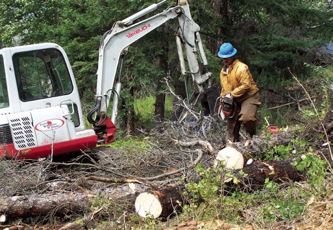
Susanne U. Rodman is the forester for the Anchorage Fire Department. She works with public and private land owners to treat forest fuels to limit the spread
and intensity of wildland fire. She has a B.S. and an M.S. in forestry while retaining the certified forester credential through the Society of American Foresters.
       Joseph C. Stam is a consultant for incident management with respect to all types of emergencies. Having served as the chief of fire and aviation for the State
of Alaska Division of Forestry for eight years and as the incident commander for the Alaska Type I Team for seven years, Mr. Stam contributes significant skill and
experience to all agency projects.
       Contributions to the Municipality of Anchorage Community Wildfire Protection Plan were made by Jennifer M. Klugh, Jason T. Kohler, Michelle Weston,
Thomas G. Kempton, Bridget C. Bushue, Frank V. Cole, local residents and a host of agency staff from within and outside of Alaska. Jennifer M. Klugh serves the
Anchorage Fire Department as the Firewise education specialist and supporting public information officer. She works with private residents to implement Firewise
principles and leads the Wildfire Mitigation Office in education and outreach. Jason T. Kohler is the aviation manager and fuels specialist for the Anchorage Fire
Department. His experience in wildland firefighting and helitack lends a high level of expertise and skill to the AFD Aviation Program. He also coordinates wildland
fire training for all AFD personnel. Michelle Weston, deputy chief of administration, is in a key leadership position for AFD by directing all support functions for
the department. In her previous position as forester with the Wildfire Mitigation Office, she co-wrote the original Anchorage Wildfire Program strategic plan: a
primary component of this Community Wildfire Protection Plan. Thomas G. Kempton, battalion chief, is the primary public information officer for the Anchorage
Fire Department and supervises the Wildfire Mitigation Office. His role extends to the Alaska Type I and II Incident Management Teams as information officer on
state and national wildland fires. Bridget C. Bushue, division chief of public affairs, supports education and communication between AFD and the community. Frank
V. Cole serves the State of Alaska Division of Forestry as the fire behavior and fire weather coordinator. His work involves fire weather interpretation and prediction
along with analysis of statewide and local fire weather. He serves incident management operations across the state of Alaska and the nation.
       Sue Mitchell of Inkworks provided editing, design, and layout for this document. Her insightful contributions made this document into a readable and useful
publication.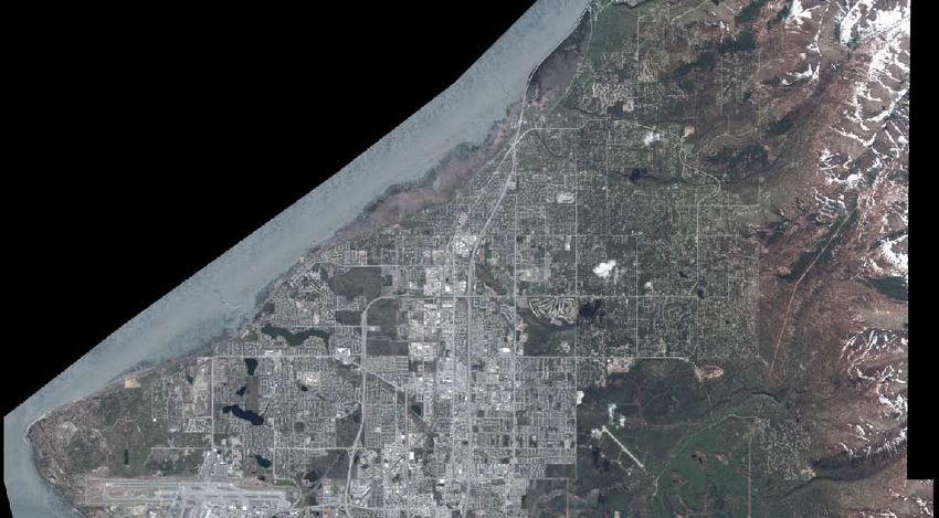
Table of Contents
Executive Summary. . . . . . . . . . . . . . . . . . . . . . . . . . . . . . . . . . . . . . . . . . . . . . . . . . . . . . . . . . . . . . . . . . . . . . . . . . . . . 1
1. Introduction . . . . . . . . . . . . . . . . . . . . . . . . . . . . . . . . . . . . . . . . . . . . . . . . . . . . . . . . . . . . . . . . . . . . . . . . . . . . . . . . 3
2. Planning Process. . . . . . . . . . . . . . . . . . . . . . . . . . . . . . . . . . . . . . . . . . . . . . . . . . . . . . . . . . . . . . . . . . . . . . . . . . . . 5
       2.1 Step-by Step-Process . . . . . . . . . . . . . . . . . . . . . . . . . . . . . . . . . . . . . . . . . . . . . . . . . . . . . . . . . . . . . . . . . . . . 5
       2.2 The Core Team . . . . . . . . . . . . . . . . . . . . . . . . . . . . . . . . . . . . . . . . . . . . . . . . . . . . . . . . . . . . . . . . . . . . . . . . . . 7
3. Community Profiles . . . . . . . . . . . . . . . . . . . . . . . . . . . . . . . . . . . . . . . . . . . . . . . . . . . . . . . . . . . . . . . . . . 8
       3.1 Anchorage. . . . . . . . . . . . . . . . . . . . . . . . . . . . . . . . . . . . . . . . . . . . . . . . . . . . . . . . . . . . . . . . . . . . . . . . . . . . . . . . 8
       3.2 Chugiak–Eagle River . . . . . . . . . . . . . . . . . . . . . . . . . . . . . . . . . . . . . . . . . . . . . . . . . . . . . . . . . . . . . . . . . . . . . . 9
       3.3 Girdwood . . . . . . . . . . . . . . . . . . . . . . . . . . . . . . . . . . . . . . . . . . . . . . . . . . . . . . . . . . . . . . . . . . . . . . . . . . . . . . . . 9
4. Community Wildland Fire Risk Assessment . . . . . . . . . . . . . . . . . . . . . . . . . . . . . . . . . . . . . . . . . . . 11
       4.1 Community Wildfire Protection Plan Boundary. . . . . . . . . . . . . . . . . . . . . . . . . . . . . . . . . . . . . . . . . . . . 13
       4.2 Wildland Fire Hazards in the Wildland-Urban Interface . . . . . . . . . . . . . . . . . . . . . . . . . . . . . . . . . . . . 13
       4.3 Value Loss Potential. . . . . . . . . . . . . . . . . . . . . . . . . . . . . . . . . . . . . . . . . . . . . . . . . . . . . . . . . . . . . . . . . . . . . . 18
       4.4 Risk of Wildland Fire Occurrence. . . . . . . . . . . . . . . . . . . . . . . . . . . . . . . . . . . . . . . . . . . . . . . . . . . . . . . . . . 19
       4.5 Alaska Interagency Fire Management Plan. . . . . . . . . . . . . . . . . . . . . . . . . . . . . . . . . . . . . . . . . . . . . . . . 21
5. Wildland Fire Response Capability . . . . . . . . . . . . . . . . . . . . . . . . . . . . . . . . . . . . . . . . . . . . . . . . . .  22
       5.1 Apparatus and Equipment. . . . . . . . . . . . . . . . . . . . . . . . . . . . . . . . . . . . . . . . . . . . . . . . . . . . . . . . . . . . . . . . 22
       5.2 Helicopter. . . . . . . . . . . . . . . . . . . . . . . . . . . . . . . . . . . . . . . . . . . . . . . . . . . . . . . . . . . . . . . . . . . . . . . . . . . . . . . 24
       5.3 Water Resource Improvements and Cataloging. . . . . . . . . . . . . . . . . . . . . . . . . . . . . . . . . . . . . . . . . . . . 24
       5.4 Wildland Fire Training and Response. . . . . . . . . . . . . . . . . . . . . . . . . . . . . . . . . . . . . . . . . . . . . . . . . . . . . . 25
6. Wildland Fire Mitigation Strategies. . . . . . . . . . . . . . . . . . . . . . . . . . . . . . . . . . . . . . . . . . . . . . . . . .  27
       6.1 Firewise Education. . . . . . . . . . . . . . . . . . . . . . . . . . . . . . . . . . . . . . . . . . . . . . . . . . . . . . . . . . . . . . . . . . . . . . . 27
       6.2 Hazard Fuel Reduction. . . . . . . . . . . . . . . . . . . . . . . . . . . . . . . . . . . . . . . . . . . . . . . . . . . . . . . . . . . . . . . . . . . 29
       6.3 Comprehensive Strategic Plan. . . . . . . . . . . . . . . . . . . . . . . . . . . . . . . . . . . . . . . . . . . . . . . . . . . . . . . . . . . . 33
7.     Memorandum of Agreement and Signature Page. . . . . . . . . . . . . . . . . . . . . . . . . . . . . . . . . . . . .  37
Appendix A: Community Fire Planning: Summary of Public Comments . . . . . . . . . . . . . . . . . . . .  39
Appendix B: List of Abbreviations and Acronyms. . . . . . . . . . . . . . . . . . . . . . . . . . . . . . . . . . . . . . . . .  43
Appendix C: References . . . . . . . . . . . . . . . . . . . . . . . . . . . . . . . . . . . . . . . . . . . . . . . . . . . . . . . . . . . . . . . . 44

                                                                                                                                                                                  iii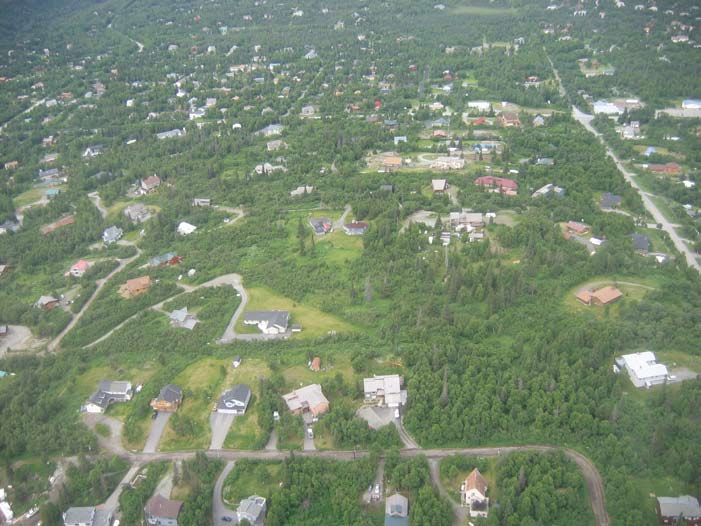
Trees killed by spruce bark beetles contribute to the wildland fire hazard fuel load, causing greater fire intensity and reducing
the fire suppression capability of ground crews.
Executive Summary

T    he Municipality of Anchorage Community Wildfire Protection Plan is a collaborative effort in re-
     sponse to the 2003 Healthy Forests Restoration Act (HFRA). The HFRA directs communities ex-
posed to wildland fire to conduct a risk assessment and create a hazard fuel mitigation plan. Anchorage
and its surrounding communities have been designated as “urban wildland interface communities with-
in the vicinity of federal lands that are at high risk from wildfire” (Federal Register 2001). Through col-
laboration with other municipal departments and federal, state, and local agencies, the Anchorage Fire
Department (AFD) has been working to mitigate the risks and hazards of wildland fire in the municipal-
ity. This process of developing a Community Wildfire Protection Plan (CWPP) for local communities
will document that work and serve as the catalyst for future projects.
     AFD has been working with its interagency partners for many years to educate the community about
the potential for wildland fires. Community awareness has increased since the disastrous 1996 Miller’s
Reach Fire in the Matanuska-Susitna Borough (454 structures lost) and from the recent spruce bark
beetle epidemic and resultant dramatic increase in hazard fuels. Just after the Miller’s Reach Fire, AFD
was awarded $200,000 from the Federal Emergency Management Agency (FEMA) to initiate an intensive
public education campaign in the Municipality of Anchorage (MOA), focusing on defensible space prep-
aration for homeowners. In 1997, AFD received a $400,000 Project Impact Grant from FEMA to con-
tinue the wildland fire awareness program. In 2001, the MOA started receiving additional federal fund-
ing to mitigate wildland fire through Firewise education, hazard fuel reduction projects, and improving
AFD’s wildland fire response capability.
     Many hazard fuel reduction projects have been accomplished since 1997 on the residential and
neighborhood levels. Although the community has experienced several significant wildland fire events in
recent years (including the 2 ½-acre Dowling Fire in 2003 and the 50-acre Otter Lake Fire in 2006), we
have been very fortunate in not having had any loss of life or property from a wildland fire.
     Residents played a key role in establishing priorities for wildland fire preparedness and mitigation
strategies in this community-based fire plan. During the 2007 initial planning process, AFD collaborated
with the community councils in the Anchorage Bowl, Chugiak–Eagle River, and Turnagain Arm areas.
Within those broad geographic areas, community council involvement ensured that neighborhood val-
ues formed the foundation of the Community Wildfire Protection Plan.
     To make wildfire preparedness a part of community life for the long term, AFD retains dedicated
staff and resources to implement the plan’s high-priority objectives during the next three years and be-
yond. Building a sustainable program that will last beyond the current funding through federal appro-
priations is a critical element in the plan. AFD continues to partner with the Federation of Community
Councils to engage the interest and participation of local residents to become prepared and to treat
public forests to reduce risk. AFD continues to improve its wildland fire suppression capability through
training and tactical response planning.

Community Wildfire Protection Plan—Municipality of Anchorage, Alaska                                     1
The wildland-urban interface exists throughout the Municipality of Anchorage; it is not limited to the perimeter of the devel-
oped area. Exposure to wildland fire is dependent upon the vegetation type, its respective fuel loading, the proximity of homes
to one another, and the fire suppression response capability.
1
 . Introduction

T     he Anchorage Fire Department (AFD) is dedicated to being prepared for wildland fire by culti-
      vating awareness in the community, reducing hazardous forest fuels, and improving its fire sup-
pression response capability. By developing the Community Wildfire Protection Plan (CWPP), AFD is
documenting its progress in mitigating the risks and hazards of wildland fire and projecting its goals
for the next three years.
     The national Firewise Communities/USA program has served as the template for developing the lo-
cal Anchorage Wildfire Program. Firewise Communities/USA encourages wildland fire preparedness
through partnerships within a neighborhood facilitated by local agencies. Key principles involve pre-
paring the home to resist ignition from a wildland fire, preparing the family to find safe shelter during
a fire, and engaging neighbors to help one another. AFD uses the existing Federation of Community
Councils (www.communitycouncils.org) to communicate with residents and to plan hazard fuel reduc-
tion projects.
     The Healthy Forests Restoration Act (HFRA), enacted by the United States Congress in 2003, empha-
sizes the need for federal agencies to collaborate with communities to reduce the risk of destructive wild-
land fires. The HFRA recognizes that a successful CWPP depends on involvement of local governments,
local fire districts, state entities, and other agencies that manage lands within and around the communi-
ty. Through this process, communities have the opportunity to influence where and how federal agencies
implement fuel reduction projects on federal lands and how federal funds are distributed for projects on
nonfederal lands, as is the case in the Municipality of Anchorage (MOA). The MOA has received federal
grants and appropriations to mitigate the risk and hazard of wildland fire since 1996. There are three re-
quirements for a complete CWPP as described in the HFRA:

1. Collaboration: A CWPP must be collaboratively developed by local and state government represen-
   tatives, in consultation with federal agencies and other interested parties.
2. Prioritized Fuel Reduction: A CWPP must identify and prioritize areas for hazardous fuel reduction
   treatments and recommend the types and methods of treatment that will protect one or more at-risk
   communities and essential infrastructure.
3. Treatment of Structural Ignitability: A CWPP must recommend measures that homeowners and
   communities can take to reduce the ignitability of structures throughout the area addressed by the
   plan.

    The HFRA emphasizes that priority for federal assistance will be given to communities that have
identified treatment areas through a CWPP. The objectives of the CWPP are to (1) help local fire dis-
tricts, local governmental agencies, and residents identify lands that pose a severe wildland fire threat;
(2) decide how to reduce hazard fuels on those lands while improving forest health; and (3) improve

Community Wildfire Protection Plan—Municipality of Anchorage, Alaska                                         3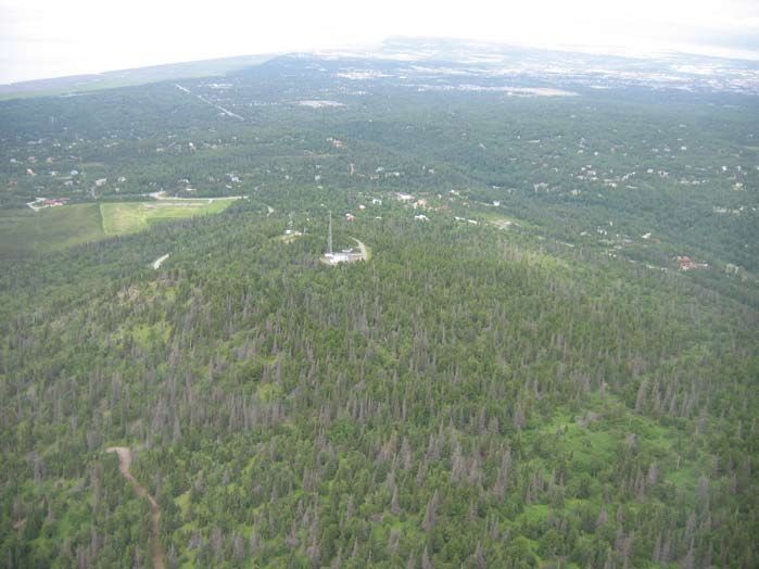
refighting response capabilities. Completing this document shows that a community has a plan to im-
fi
plement projects and therefore is well-suited to receiving federal and state grants.
The existing Anchorage Wildfire Program is consistent with these requirements for a CWPP. AFD
staff partnered with local, state, and federal agencies to develop a formal plan in 2001. AFD established
the Wildfire Mitigation Office and hired dedicated staff to promote Firewise homes and treat hazardous
forest fuels. At the residential level, Firewise practices help keep the home from catching fire and keep
the family safe during a wildland fire. AFD initiated the Anchorage Fire Exposure Model (AFEM) to
assess risks and hazards in order to prioritize fuel reduction projects. Where private property meets pub-
lic property, forest management helps keep fire from crossing these boundaries. These program elements
are integrated into AFD fire suppression operations through the annual wildland fire refresher and mul-
tiagency simulation exercises.
The HFRA requires strong community involvement and commitment so that local knowledge and
perspectives are included in the plan. To meet this requirement, 20 community councils have been di-
rectly involved in this process, along with individual residents at additional community meetings. Other
entities such as Chugach State Park, MOA Heritage Land Bank, MOA Parks and Recreation Department,
MOA Anchorage School District, U.S. Forest Service Chugach National Forest, Bureau of Land Manage
ment Campbell Tract, the public at large, and local leaders were contacted for input into the final plan.
Annual reviews by the AFD staff, agency partners, consultants and community council members will
provide updates to the plan, document project accomplishments, and schedule additional projects. AFD
identified action items to initiate and continue mitigating wildland fires in the wildland–urban interface.
This comprehensive list includes programmatic elements completed since 2001 and projections for the
next three years.
The potential for loss of life and property is directly related to the risk of ignition and the hazard-
ous fuels that support fire. Case studies show that people and structures can survive a wildland fire when
Firewise principles are implemented. The Anchorage Fire Department provides technical support to cre-
ate Firewise homes as a key objective of the Anchorage Wildfire Program. The independent and self-reli-
ant nature of Alaska residents forwards their capacity for individual preparedness. AFD uses Firewise
Communities/USA and Emergency Watch to harness this energy. As shown in the cases of the 2003 Cedar
Fire and the 2001 Cerro Grande Fire, homes them-
selves become the primary fuel supporting wild-
land fire.
Firewise-compliant homes, private and public
forest stewardship, and a well-trained fire suppres-
sion force are critical elements to our community’s
survival during a wildland fire. The MOA CWPP
addresses the Anchorage Fire Department’s role in
mitigating wildland fire through partnerships and
preparedness.
Conner’s Lake and bog area near Jewel Lake Road,
Anchorage.
4 Community Wildfire Protection Plan—Municipality of Anchorage, Alaska2
2. Planning Process
A CWPP enables a community to clarify and refine its priorities for protecting life and property in
the wildland–urban interface. This collaborative process unites federal, state and local governments
with other interested parties to discuss mutual concerns in the wildland-urban interface. In addition,
these groups can review the risk and create a plan for action. The CWPP process allows all interested
parties to become involved and to address challenges such as local wildland firefighting capabilities;
defensible space around homes, public buildings, and other improvements; and how to prioritize land
management activities on public lands. A CWPP can be incorporated into a Firewise program and used
by working groups, individual property owners, fire departments, and government wildland fire man-
agement personnel.
The 2004 handbook Preparing a Community Wildfire Protection Plan: A Handbook for Wildland-Urban
Interface Communities was a guide for completing the Municipality of Anchorage’s Community Wildfire
Protection Plan.
2.1: Step-by-Step Process
The handbook provides eight steps to guide the development of comprehensive fire plans for the respec-
tive community council areas throughout the municipality:
Step 1: Convene decision makers
Step 2: Involve federal agencies
Step 3: Engage interested parties
Step 4: Establish a community base map
Step 5: Develop a community risk assessment
Step 6: Establish community hazard reduction priorities and recommendations to reduce structural
ignitability
Step 7: Develop an action plan and assessment strategy
Step 8: Finalize the Community Wildfire Protection Plan
Step 1: Convene Decision Makers
The Anchorage Wildfire Steering Committee developed the initial wildland fire mitigation plan that
is the foundation for this CWPP. This team of interagency experts also provided oversight to subcom-
mittees focusing on Firewise education, wildland fire suppression, hazard fuel reduction projects, and
community risk assessment. Currently, the Anchorage Fire Department’s Wildfire Mitigation Office
performs the daily tasks to implement Firewise education and hazard fuel reduction. Support from
additional AFD staff is critical in providing the synergy between Firewise and fire suppression opera-
tions. Major program decisions are currently made within AFD through consultation with agency part-
ners and municipal management staff. To formalize this Community Wildfire Protection Plan for the
Community Wildfire Protection Plan—Municipality of Anchorage, Alaska 5Municipality of Anchorage, authority is granted from the mayor; the fire chiefs for Anchorage, Girdwood
and Chugiak; and the area forester for the Alaska Division of Forestry.
Step 2: Involve Federal Agencies
Managers and field staff from the Alaska Division of Forestry, U.S. Forest Service, Bureau of Land
Management, National Park Service, U.S. Fish and Wildlife Service, and U.S. Army Ft. Richardson have
participated in developing and implementing the Anchorage Wildfire Program. Their technical support
continues to improve operational standards and procedures for the three focal elements of the program:
education, hazard fuel mitigation, and wildfire suppression capability.
Step 3: Engage Interested Parties
AFD and partner agencies have attended many community council meetings, homeowner association
meetings, local events, and corporate safety meetings. Local residents have expressed sincere interest in
learning about wildland fire risk and homeowner preparedness. Many of these local voices have partici-
pated in steering committee meetings, raising local issues and concerns, providing valuable suggestions,
and offering constructive criticism to improve program delivery to the community. AFD returns to
community council meetings regularly to further engage residents and local leaders while accepting sug-
gestions to develop and maintain an effective community fire plan.
Step 4: Establish a Community Base Map
The Municipality of Anchorage has a comprehensive set of mapping layers that detail a number of physi-
cal attributes across all land ownerships. Available through the internet, municipal mapping layers sup-
port land ownership boundaries, satellite imagery, topography, and streets and addressing, among many
other datasets.
Step 5: Develop a Community Risk Assessment
In assessing the exposure of Anchorage area neighborhoods to wildfire, AFD staff use a suite of tools to
evaluate fuel types, potential fire behavior, likely ignition sources, value loss potential and fire suppres-
sion capability. These tools include several computer models along with field reconnaissance and coop-
erative planning with Alaska Division of Forestry. The Anchorage Fire Exposure Model (AFEM) yields
a picture of exposure to wildfire risk. This model analyzes many of the datasets used in the community
base map in combination with expected fire behavior.
Step 6: Establish Community Hazard Reduction Priorities and Recommendations
to Reduce Structural Ignitability
The AFEM evaluates the vegetation (or fuel) with respect to its expected fire behavior. Forest treatment
projects are prioritized based on these variables, population density, and the potential for a fire ignition.
Firewise principles are integrated into the Anchorage Wildfire Program through individual home as-
sessments, available to all area residents. Homeowners are provided with a list of recommended actions
to reduce the potential for a structural ignition. The Firewise principles are the backbone of mitigating
wildland fire at the urban interface: they are described in all of the educational media published by AFD.
6 Community Wildfire Protection Plan—Municipality of Anchorage, AlaskaStep 7: Develop an Action Plan and Assessment Strategy
The municipality is divided into three major areas: Anchorage Bowl, Turnagain Arm, and Chugiak–
Eagle River. Within these three areas, assessments and action plans are specified at the community
council level with reference to the Anchorage Fire Exposure Model (AFEM). By using this existing
structure, AFD is able to work with cohesive neighborhoods to plan forest treatment projects and ex-
tend Firewise principles directly to the residents.
Step 8: Finalize the Community Wildfire Protection Plan
The draft plan will be routed through the leaders of participating organizations to attain consensus
on strategies and actions identified. The final plan will be available to the public and published widely.
Implementing and updating will be an ongoing process within each community council area.
2.2: The Core Team
Since the formal inception of the Anchorage Wildfire Program in 2001, Anchorage Fire Department staff
has worked in cooperation with other municipal departments and agency representatives from local,
state, and federal organizations. Initially, a multiagency group (Steering Committee) developed a plan of
action for mitigating wildland fire risks and hazards in the wildland-urban interface of the Municipality.
That plan has adapted to technical advances in fire and fuel management, wildland fire training, public
outreach, and the changing community.
2001 Steering Committee: Original Membership*
Harry Kieling Municipal Manager Municipality of Anchorage
Dr. Richard Dworsky Director, State and Federal Grants Municipality of Anchorage
John Fullenwider Fire Chief Anchorage Fire Department
Hal Wiley Deputy Chief, Operations Anchorage Fire Department
Sue Rodman Forester Anchorage Fire Department
Michelle Weston Forester Anchorage Fire Department
Bill Sobers Executive Director Anchorage Soil & Water
Conservation District
Bill Beebe Fire Management Officer Alaska Department of Natural
Resources, Division of Forestry
John See Director, Urban and Community Forestry Alaska Department of Natural
Resources, Division of Forestry
Ken Bullman Area Forester Alaska Department of Natural
Resources, Division of Forestry
Al Meiners Superintendent Alaska Department of Natural
Resources, Chugach State Park
Kelly Kane Fire Specialist USDA State and Private Forestry
*Many of these members now serve in different capacities or with different agencies.
Community Wildfire Protection Plan—Municipality of Anchorage, Alaska 73 Community Profiles
3.
This section is excerpted from the Anchorage 2020 Comprehensive Plan.
3.1: Anchorage
Anchorage is located in southcentral Alaska at the head of Cook Inlet. It lies about 1,400 air miles
northwest of Seattle. The Municipality of Anchorage encompasses 1,955 square miles between northern
Prince William Sound and upper Cook Inlet. The area consists of mostly rugged mountainous terrain
and coastal plains. Only 10% of the municipality is inhabited; 84% of the total land base is within the
Chugach National Forest and Chugach State Park.
Most residents live in the Anchorage Bowl, which covers approximately 100 square miles and is sur-
rounded by Chugach State Park, Turnagain Arm and Knik Arm of Cook Inlet, Elmendorf Air Force
Base, and Fort Richardson Military Reservation. Anchorage residents outside the bowl either live on mil-
itary reservations, farther north in the suburban/rural community of Chugiak–Eagle River, or in small
settlement areas along Turnagain Arm.
History
Early inhabitants in the Anchorage area were the Eklutnas, a small group of Athabaskan Indians. The
village of Eklutna is near the northern end of the municipality. The earliest Caucasians in the area were
Russian fur traders and missionaries, later followed by gold prospectors and traders passing through on
their way to other gold deposits. Some stayed to prospect the area, resulting in a few mining camps and
small settlements along Turnagain Arm, most
notably Girdwood. However, Anchorage was
not established until the federal government
decided to build a railroad from the tidewater
community of Seward to the interior gold min-
ing community of Fairbanks.
The city of Anchorage was founded when
the government established the field headquar-
ters for the construction of the Alaska Railroad
at Ship Creek in 1914. Shortly thereafter, a tent
city was set up along the shores of the creek by
people seeking work on the railroad or business
opportunities associated with it. The following
year, a townsite auction of 600 lots established
the downtown grid pattern that is still in place
today. Anchorage incorporated as a city in 1920.
8 Community Wildfire Protection Plan—Municipality of Anchorage, AlaskaDuring World War II, Anchorage’s strategic location made it well positioned for defense support fa-
cilities serving the North Pacific. This advantage resulted in the building of Elmendorf Air Force Base
and U.S. Army Fort Richardson. During the same period, construction of the Glenn and Alaska high-
ways gave Anchorage an overland link through Canada to the Lower 48. Anchorage’s strategic location
continued to play a valuable role during the conflicts in Korea and Vietnam and throughout the rest of
the Cold War era. It remains a vital national security asset today.
Culture and Demographics
For most of its history, Anchorage grew as a community of immigrants: newcomers from outside the
state and Alaska Natives from rural areas within the state. At the time of the 1990 census, approximately
one-quarter of Anchorage’s residents were born in Alaska.
For decades, a seasonal boom-bust economy and military personnel rotations have made Anchorage
a fast-growing town of transients. Anchorage’s diverse demographics are characterized by racial and eth-
nic minorities accounting for 27% of the population. Alaska Natives make up eight percent of the total
population and are the largest minority group.
Anchorage
Vicinity
Community Wildfire Protection Plan—Municipality of Anchorage, Alaska 9Economy
Anchorage is the State’s primary transportation, communication, trade, service, and finance center.
Anchorage is home to 42% of the state’s population and accounts for 47% of the employment. Nine of
the 10 largest private employers are headquartered here. More than 70% of the state’s legal, business, en-
gineering, and management service employment is based in Anchorage.
Transportation
Anchorage’s transportation system is made up of several major elements, including the Port of
Anchorage, Ted Stevens Anchorage International Airport, and the Alaska Railroad terminal. Access
to the Interior is provided by the Glenn and Parks highways, and access to the Kenai Peninsula is pro-
vided by the Seward Highway. The Alaska Railroad runs from the Port City of Seward to its terminus in
Fairbanks. Anchorage is also the aviation hub for southcentral Alaska and provides commuter aviation
and charter service to the western Interior.
3.2: Chugiak–Eagle River
The Chugiak–Eagle River area north of the Anchorage Bowl began to develop shortly after the 1900s,
when traders and prospectors began to arrive looking for minerals and routes to the gold fields. Ekultna
was the dominant settlement in the area in the 1920s. However, growth occurred closer to Anchorage
with the development of the U.S. Army Fort Richardson and Elmendorf Air Force Base. Military person-
nel and civilians associated with military construction jobs moved into the Chugiak–Eagle River area,
and commercial enterprises soon followed.
In the Chugiak–Eagle River area, local retail growth in response to the increasing population has
made retail trade the area’s largest employment sector. Service-related jobs and the government are the
second and third largest employers in the area, respectively. A large portion of the working population
commutes to the Anchorage Bowl for employment.
3.3: Girdwood
Girdwood was founded just before the turn of the century as a supply and transport center for the area’s
placer and lode gold mines. The mining claims operated through the 1930s, when they stopped either
due to the exhaustion of lode deposits or lawsuits and presidential orders to stop the environmentally
destructive hydro-mining. In the 1920s, the construction of the Alaska Railroad benefited Girdwood.
Development in the Girdwood area was revived in 1949 with construction of the Seward Highway. Much
of the growth and development in Girdwood since the 1950s has been associated with skiing and other
recreational opportunities.
The service industry is Girdwood’s largest employment sector, with the largest employer being the
Alyeska Resort. The construction industry is second, and the third largest employment sector is trade,
mostly associated with tourism. Girdwood’s economy is likely to remain based on tourism and recre-
ation because there are plans for additional hotels and new recreational amenities. Many of the jobs in
Girdwood are seasonal and are associated with the ski industry in the winter or with tourism during the
summer. Many Girdwood residents also commute to Anchorage for employment.
10 Community Wildfire Protection Plan—Municipality of Anchorage, Alaska4 Community Wildland Fire Risk Assessment
4.
T he purpose of a community risk assessment is to locate wildland fire hazards in the wildland–urban
interface, to identify the values at risk, and to determine and prioritize hazard fuel reduction proj-
ects. Risk assessments also consider wildland fire occurrence, local preparedness, and wildland firefight-
ing capabilities. The risk assessment process is ongoing and future assessments will be attached as adden-
dums to this plan.
The Anchorage Fire Exposure Model (AFEM), created by Geographic Resource Solutions, calculates
the fire exposure across designated areas within the Municipality of Anchorage, based on 30-by-30 meter
pixels. Exposure is the relative ranking of a location’s exposure to the impact of wildfire. The exposure is
based on the cumulative effect of four components (GRS 2007):
• Hazard, the potential to burn, is based on the structure of forest fuels (horizontal-vertical arrange-
ment) combined with slope and aspect to yield flame length and rate of spread. The AFEM uses
nationally accepted fuel models to estimate expected fire behavior through both the Anderson and
Scott and Burgan types.
• Risk, the potential for a fire to ignite, stems primarily from human-caused fires: residential brush
burning, recreational fires, fireworks, and homeless person camps. Roads and trails are considered
access for humans to ignite fires.
• Values, the potential for loss of life and property, include homes, public facilities, businesses, and
utility infrastructure. This element does not include the monetary value associated with each struc-
ture or pixel, but rather evaluates its size and land use.
• Suppression, AFD’s response capability, estimates how quickly water can be applied to the fire with
consideration for the distance from a fire station, accessibility, and proximity to a water source.
The AFEM is used on conjunction with two other software programs that calculate fire spread at dif-
ferent scales. FlamMap software was developed by Systems for Environmental Management in Missoula,
Montana. It models fire behavior characteristics, including spread rate, flame length, and crown fire ac-
tivity, by evaluating the fuel model, wind, and other conditions at the pixel level. FarSite software applies
a combination of many pixels to the designated landscape area. It models the growth of a fire across the
landscape using wind and weather data, fuel types, aspect, and slope to interpret fire behavior outputs.
The resulting raster maps show the extent of a fire over a specified time period. This type of output can
be used to determine the best use of available fire suppression resources such as fire engines, helicopters,
air tankers, and fire crews.
In evaluating each component of the AFEM, AFD has selected areas where mitigation through forest
treatment may limit the area’s exposure to wildfire. For example, a municipal-owned parcel that has high
fuels hazard, high ignition risk, and is close to a subdivision would be prioritized for fuels reduction. Next,
AFD would work with the local community to write a suitable site prescription that addresses the forest fu-
els and forest health while carefully adjusting for stream and riparian zone protection and aesthetic values.
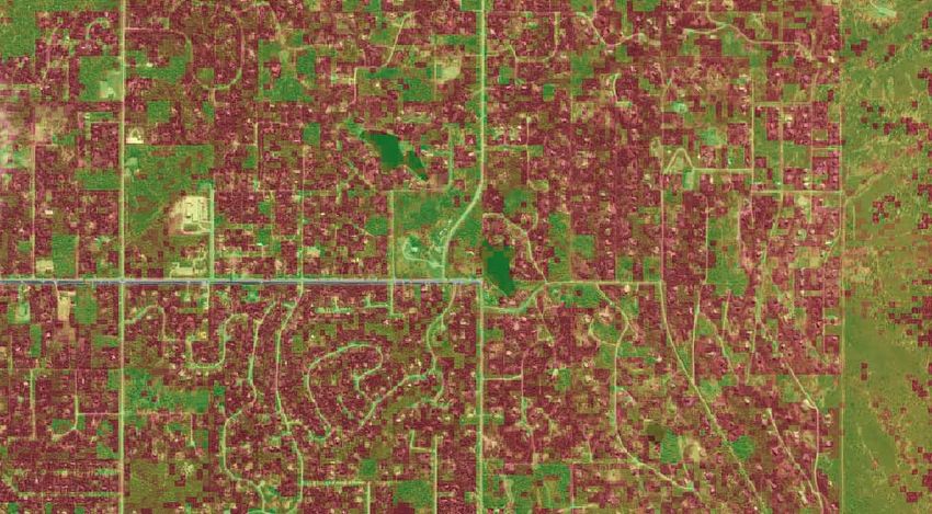
Community Wildfire Protection Plan—Municipality of Anchorage, Alaska 11Upper Anchorage Hillside Wildfire Exposure
Far North Bicentennial Park
Abbott Road
Hillside Drive
Chugach State Park
O'Malley Road
Upper Huffman Road
Wildfire Exposure
Value
-
High : 82.492409
Low : 5.000000
Sample of the Anchorage Fire Exposure Model (AFEM) of the Anchorage Hillside area, showing wildfire exposure with
an emphasis on value.
08.13.07 Anchorage Fire Department. S.Barkwood
12 Community Wildfire Protection Plan—Municipality of Anchorage, AlaskaSpecial considerations for many neighborhoods throughout the municipality include the topography
and water availability. Due to the east-west orientation of canyons and valleys, north-south road corri-
dors are often discontinuous. This increases fire suppression response times. Water availability is severely
limited because much of the wildland–urban interface has well and septic tank systems with limited
pressure instead of hydrants pressurized by the municipal water system.
4.1: Community Wildfire Protection Plan Boundary
The wildland–urban interface can be described as the space where structures and other human-made
development meet and intermix with the natural vegetation that often serves as fuel for a wildland fire.
Wildland fire in the interface is one of the most costly and dangerous types of fires faced by fire manag-
ers today. Federal, state, and local governments place a high priority on working collaboratively to ad-
dress the wildland fire threat to communities within the wildland–urban interface. Some proven meth-
ods of reducing the risk of wildland–urban interface fires include
• reducing the volume of wildland fuels in the interface area;
• breaking up the vertical and horizontal continuity of vegetation;
• instructing and educating the public on Firewise concepts;
• involving individual landowners in implementing Firewise concepts on their properties;
• developing improved wildland fire suppression capabilities and infrastructure at all levels; and
• decreasing the incidence of human-caused wildland fires through multiagency prevention efforts.
The Healthy Forests Restoration Act describes the WUI as those areas within or adjacent to an at-
risk community and defaults to ½ to 1 ½ miles from the community boundaries. The MOA CWPP is
designed for all neighborhoods within the Municipality of Anchorage, from Portage to Eklutna. Inside
of this political boundary, additional specific risk assessments and action plans are being developed for
community council areas that have a high potential for a wildland–urban interface fire, as determined
by the AFEM and field reconnaissance. Other large land bases that would impact the spread and inten-
sity of wildland fire include Chugach State Park, Bureau of Land Management (BLM) Campbell Tract,
U.S. Forest Service Chugach National Forest, U.S. Army Ft. Richardson, and lands held within private
ownership.
4.2: Wildland Fire Hazards in the Wildland-Urban Interface
Alaska’s Key Wildland Fire Fuels
• Fire-prone areas are in flat and rolling terrain below 3,500 feet in elevation.
• Homes in the boreal forest of major population centers.
• North-facing slopes are poorly drained, underlain by permafrost, and host black spruce.
• South-facing slopes are fairly well drained and typically host deciduous species.
• Rivers meander and have stringers of white and black spruce and mixed deciduous trees.
The fire “problem” at the wildland–urban interface is solely dependent upon the existence of struc-
tures within or adjacent to forests that naturally burn. Many methods of construction and materials
are available to homeowners that will increase a home’s resistance to an external fire ignition. These
Community Wildfire Protection Plan—Municipality of Anchorage, Alaska 13Municipality of Anchorage Community Councils
Anchorage Bowl
Government Hill
Downtown Mountain View
Russian
South Addition FairviewAirport Jack Northeast
Heights Park
North Star
Rogers
Turnagain Park Scenic
University Area
MidtownTudor Foothills
Spenard Area
Campbell Park
Taku/Campbell Basher
Sand Lake
Abbott Loop
Mid-Hillside Hillside
Bayshore/Klatt East
Huffman/
O'Malley
Glen
Old Seward/ Alps
Oceanview
Rabbit Creek
Bear Valley
-
Anchorage Bowl Community Council area.
14 08.07.07 Anchorage
CommunityFire Department.
Wildfire S.Barkwood
Protection Plan—Municipality of Anchorage, AlaskaEagle River - Chugiak
Eklutna Valley
Chugiak
Birchwood
Municipality of Anchorage Community Councils
Eagle
River
Eagle River Valley Turnagain Arm Communities
South Fork
Eagle River–Chugiak Community Council area.
-
08.07.07 Anchorage Fire Department. S.Barkwood
Girdwood
Turnagain Arm
Portage Valley
Turnagain Arm Community Council area.
Community Wildfire Protection Plan—Municipality of Anchorage, Alaska 15measures and the implementation of the Firewise principles are critical to protecting a structure from
a wildland fire. Once ignited, a structure is a dense fuel that burns hot while also projecting burning
embers that may ignite more brush fires or structures. This same phenomenon applies to forest fires, be-
cause burning embers are carried in front of the fire to ignite spot fires in advance of the main fire. The
situation in the Municipality of Anchorage demonstrates that the extent of the wildland-urban interface,
or intermix, extends throughout many developed neighborhoods. Personal and structural exposure to
wildland fire exists for individual residents, considering the ignition potential from human-caused fires,
the combustibility of homes themselves, and the proximity of homes to one another that can contrib-
ute to fire spread and intensity. While AFD does assume a strong responsibility to partner with public
land managers to treat forested areas, homeowner preparedness through Firewise practices is also very
important.
The forests across the Municipality of Anchorage represent the transition between coastal and boreal
forest types. Stands of white, black, Sitka, and Lutz spruce mingle with mixed hardwoods, muskegs, and
alder thickets. Hemlock is common on slopes and along the Turnagain Arm. Above treeline, expanses of
tundra shrubs, herbs, and lichen coat the mountains beneath thousands of acres of glaciers.
The coniferous stands of the boreal forest support high-
intensity fire due to their stand structure and chemical compo-
The goal of the Anchorage
sition. A surface fire depends on the fuels on the forest floor, in-
Wildfire Program is for
cluding mosses and duff layers of the soil stratum. Intermediate
homes and people to survive
sized fuels such as branch wood combine with larger fuels such
a wildland fire without
as logs to increase the intensity of the fire. Persistent branching
having an associated
of white, black, and Lutz spruce amid tall shrubs creates a ladder
residential disaster.
effect. In dry, windy conditions, a vigorous surface fire can ig-
nite these lower branches and cause a crown fire. Lichen growth
on spruce tree branches and volatile organic compounds in spruce needles contribute to the volatility of
this species.
Native bluejoint reed grass (Calamagrostis canadensis) is the primary carrier of wildland fire in
southcentral Alaska. This fuel type is most dangerous in spring, before green-up. The dry cured mat of
grass resembles straw. Wind can quickly spread a small grass fire across tens of acres before firefighters
arrive. Flame lengths in grass frequently exceed four feet in length, exceeding the capability of firefight-
ers on the ground. The danger of this fuel type cannot be overestimated. It is the fuel that has caused
hundreds of homes to burn throughout Alaska, including in the 2007 Caribou Hills Fire. This grass type
occurs in forest openings common in the wake of the spruce bark beetle epidemic, fire, and timber har-
vesting. The hazard of this fuel type is easily mitigated by annual mowing. In managed areas, this spe-
cies of grass may be replaced by other native grasses, although the success of this technique is still being
monitored.
Black spruce stands, common on lowland and upland sites throughout the state, present a particular-
ly dangerous fuel type. Sites are typically poorly drained and are almost always underlain by permafrost.
Feather mosses dominate the forest floor in these stands; these fine fuels react quickly to dry conditions
and significantly increase fire behavior. Tree branches extending to or near the ground and dead branch-
es draped with bearded lichen contribute to the extreme flammability of this fuel type and lead to crown
fires.
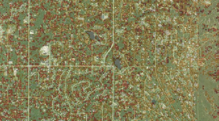
16 Community Wildfire Protection Plan—Municipality of Anchorage, AlaskaUpper Anchorage Hillside Fire Behavior
Far North Bicentennial Park
Abbott Road
Hillside Drive
Chugach State Park
O'Malley Road
AK_Viereck_40 Flame Length ft
Very Low 0-1 ft
Upper Huffman Road
Low 1-4 ft
Moderate 4-8 ft
-
High 8-12 ft
Very High 12-25 ft
Extreme 25-50 ft
Upper Anchorage Hillside fire behavior map showing relative flame lengths based on the vegetation type, aspect,
and slope.
08.13.07 Anchorage Fire Department. S.Barkwood
Community Wildfire Protection Plan—Municipality of Anchorage, Alaska 17White spruce typically displays less intense fire behavior than black spruce. Although more com-
monly found on upland sites, it also occurs in stringers and stands along river bottoms and valleys.
Crown fire and torching rarely occurs in white and Lutz spruce.
Deciduous tree species include birch, aspen, and poplars. Typically these forest fuel types do not burn
with high intensity but are difficult to extinguish because of deep leaf litter and longer intervals between
fires. Deciduous forest species are often in mixed stands with black and white spruce. Deciduous stands
exhibit less intensity and may be used as a fire break in
certain conditions. However, this fuel type burns readily
in late summer if dry conditions persist.
Beetle-killed spruce timber represents a dynamic fuel type. Soon after the tree dies, the red needle
phase can support dangerous crown fires. Dry branches and crowns may ignite from surface fire in nee-
dles, grasses or organic layers. Five to 10 years after an
The potential for southcentral infestation, the beetle-killed spruce trees fall down as the
Alaska’s boreal forest to burn base of the tree rots from red belt fungus and/or carpen-
is exacerbated by the extent of ter ants and they become susceptible to wind-throw. As
the spruce bark beetle epidemic, the forest canopy opens, bluejoint reed grass
increasing the fuel loading on (Calamagrostis canadensis) invades the site. Combined
each acre to increase a fire’s with forest debris accumulating from decadent trees
intensity. There are approximately breaking down over time, the cumulative fuel complex is
three million acres of forested dangerous. The severe fires that burn in these heavy fuels
land impacted by the beetle. The result in ecological damage. Also, snags act as a receptor
U.S. Forest Service, U.S. Fish and for aerial firebrands and an overhead safety hazard to
Wildlife Service, and the Alaska firefighters. Firefighters cannot safely fight fire on the
Division of Forestry continue ground because they can’t move through the forest and
working with local government retreat to safety zones. This increases the dependence on
agencies to mitigate the aerial fire suppression resources such as helicopters and
consequences of wildland fire in air tankers, often in short supply during the wildland fire
these forests. season.
The 2006 report of Forest Health Conditions in
Alaska (USDA Forest Service 2007), compiled by the
U.S. Forest Service’s Alaska Region and the Alaska Department of Natural Resources, stated that spruce
bark beetle activity in the Municipality of Anchorage was estimated at 2,500 newly impacted acres in the
Bird and Indian Creek valleys along the Turnagain Arm. Over 85,000 acres across the MOA have been
impacted during the past two decades. Statewide, this impact exceeds three million acres of forest land,
with over 119,000 acres of activity detected in 2006.
4.3: Value Loss Potential
Defining characteristics of the Municipality of Anchorage include its centrality of commerce, open green
spaces, wildlife, and dramatic mountain views. Fire in the boreal forest that is common in the munici-
pality is a natural force that creates and changes this ecosystem. Choosing to live in this environment
places a responsibility on each resident, because fire can and will happen. Choosing to be prepared al-
18 Community Wildfire Protection Plan—Municipality of Anchorage, Alaskalows residents to survive a fire event and sustain this lifestyle. Protecting these values must incorporate
Firewise principles for homes, forest management, diligent fire response training, and a well-maintained
fleet of firefighting apparatus.
Throughout the municipality, hundreds of homes are nestled in the boreal forest. The potential
for fire to spread through these neighborhoods combined with the limitations of the road system and
topography, creates a challenge for fire suppression. In many of these areas, fire engines are challenged by
narrow gravel roads, dead ends, and steep grades. Response times and maneuverability may be consider-
ably limited. With the potential for panic during a serious wildland fire, the risk for a vehicular accident
and personal injury increases dramatically for both civilians and emergency personnel.
The AFEM evaluates only human-made improvements: public infrastructure, homes, schools and
other facilities. This objective methodology allows fire management staff to plan forest treatment proj-
ects on public lands and conduct outreach to specific neighborhoods with high risk of structural loss.
4.4: Risk of Wildland Fire Occurrence
Boreal forests throughout southcentral Alaska experience wildland fire at varying intervals and inten-
sities, depending on annual weather patterns, fire ignitions, and moisture content of the vegetation.
Springtime before green-up and late summer often deliver dry weather and warm winds.
The wildland fire history data for the Anchorage Bowl and Eagle River Valley was tabulated for the
period 2001 through 2006, yielding 622 calls that burned 200.3 acres (see table below). The majority of
these wildland fires were of an undetermined origin. These are often instances where the fire was very
small in size or already out upon arrival, making determination of the cause difficult or impossible. The
misuse of fire in an unintentional way accounts for fires such as burn piles or campfires that were started
for a specific, controlled purpose and became out of control. Intentional fires or those started with in-
cendiaries accounted for 82 fires burning 12.7 acres. These fires are likely started by juveniles experi-
menting with fire but without any intention to cause harm. Cigarette smoking caused 65 fires over the
past six year. Lightning or other acts of nature caused 26 fires, burning 18.1 acres. Fires caused by equip-
ment accounted for 42.7 acres burned, including the 40-acre Otter Lake Fire at U.S. Army Ft. Richardson
on May 23, 2006. It was caused by welding sparks that ignited grass along the railroad tracks.
Wildland Fires in the Municipality of Anchorage, 2001–2006
Cause Number Percent Acres
Undetermined/Other 260 41.80 76.3
Misuse of Fire/Unintentional 176 28.30 41.2
Intentional/Incendiary 82 13.18 12.7
Smoking 65 10.45 9.3
Act of Nature/Natural 26 4.18 18.1
Equipment 13 2.09 42.7
TOTAL 622 100.00 200.3
Wildland fires in the MOA are usually human-caused. Human-caused wildland fires account for
96% of fire ignitions in the MOA since 2001. However, lightning strikes have increased in frequency in
recent years, with several strikes recorded in Anchorage in 2005. In the AFEM, the risk of human-caused
Community Wildfire Protection Plan—Municipality of Anchorage, Alaska 19fire ignition is based on the proximity of an area relative to human concentration. Roads and trails are
weighted higher than areas with no access to reflect the potential for a human to ignite a fire. As shown
in the risk map, ignition potential is shown as high near transportation corridors.
Alaska is a vast state, encompassing 375 million acres with approximately 220 million acres vulnera-
ble to wildland fire. During the Alaska interagency fire management planning process in the early 1980s,
Alaska was divided into four generalized geographic areas in an effort to describe fire regimes. These fire
regimes are Southeast, Southcentral, Interior, and the Arctic–West Coast. Over the past 10 years, fires
have burned millions of acres across these regions, with the least impact occurring in the Arctic.
The Municipality of Anchorage falls entirely within the southcentral fire regime, which is in the
transition zone between marine and continental climate influences. The majority of fire starts in this
regime are human-caused, but lightning is also a factor. Vegetation is a mix of tussock-tundra, conifers,
and deciduous forests. The area receives an average of 60 inches of precipitation and averages 188 fires
per year. Burning intensity is moderate to extreme, and resistance to control is moderate to high. This
regime has a serious wildland-urban interface problem. The 1996 Miller’s Reach Fire burned 37,700 acres
and destroyed 454 structures. This fire demonstrated that even with road access, densely populated re-
gions of the state can suffer disastrous consequences from wildland fire.
In the last 10 years, the State of Alaska has averaged 478 fires each year; 30% ignite from lightning
strikes and 70% are human-caused (Alaska Department of Natural Resources July 2007). Lightning sea-
son starts in mid-May and generally peaks by mid-July. The majority of the human-caused ignitions oc-
cur on the road system in the southcentral and interior fire regimes.
Wildland-urban interface fires challenge suppression agencies in Alaska just as they do in other parts of
the country. The most acute increase in population and subsequent increased housing density at the inter-
face, on the road system, is occurring on the Kenai Peninsula, in the Matanuska-Susitna Borough, and near
Anchorage and Fairbanks. These areas all have the classic wildland–urban interface problems associated
with rapid population growth without adequate zoning or fire planning.
Key Wildland Fire Weather Factors (Stam 1999)
• There is no “typical” weather pattern for any part of Alaska.
• Weather prediction in Alaska is difficult.
• Strong high-pressure systems can dominate for days with clear skies, warm temperatures, and low
humidity.
• Daily thunderstorm activity and atmospheric conditions during these periods can contribute to
high-intensity, plume-dominated, blow-up fires.
• High-pressure systems can break down rapidly. Cool, moist arctic air can move in, followed abruptly
by a return of high pressure and good burning conditions.
• Summer temperatures range from 50 to 85°F, with occasional readings in the 90s.
• Winds are variable, depending on local terrain. Winds can sometimes exceed 80 mph.
• Mountain ranges, glaciers, and permanent snowfields can cool air masses, causing down-slope flows.
• The 24-hour daylight in June and July decreases the normal daily differences in temperature and
relative humidity. This limits “recovery” of humidity that is common in the Lower 48, where fire ac-
tivity decreases dramatically during the evening hours.
• Critical weather factors are:
20 Community Wildfire Protection Plan—Municipality of Anchorage, Alaska1. Heavier fuels will burn at 50% relative humidity.
2. Relative humidity below 30% and temperatures in excess of 80°F indicate extreme fire behavior
in black spruce.
3. Winds at 20 mph and higher contribute to extreme fire behavior.
The interagency fire community in Alaska adopted the Canadian Forest Fire Danger Rating
System (CFFDRS) for predicting fire danger. This interagency decision was made in the early 1990s
based on the fact that the CFFDRS was developed in fuels similar to those in Alaska and at similar
latitudes. The Canadian Forest Service has provided technical support to Alaska fire research projects
and suppression policies.
4.5: Alaska Interagency Fire Management Plan
Virtually all forested lands in Alaska are covered by the Alaska Interagency Fire Management Plan,
which was developed in the 1980s to provide a coordinated and cost-effective approach to fire manage-
ment on all lands regardless of ownership. The plan is an interagency document and has been signed by
all major landowners in Alaska. It classifies forested lands into four fire management categories: critical,
full, modified, and limited. The fire management levels are evaluated based on the protection of human
life, private property, and pre-identified high-value resources. All of the lands in the Municipality of
Anchorage (except for some uninhabited areas in the Chugach Mountains) are classified as critical, full,
or modified protection areas and receive aggressive initial attack.
The Big Su Fire, June 2007.
Community Wildfire Protection Plan—Municipality of Anchorage, Alaska 215 Wildland Fire Response Capability
5.
T he Anchorage Fire Department, Girdwood Volunteer Fire Department, and the Chugiak Volunteer
Fire Department have embarked on an aggressive wildland fire preparedness program formally
starting in 2001, coinciding with the first federal appropriation for wildland fire mitigation. The contin-
ued development of the urban-interface areas of the municipality in conjunction with the spruce bark
beetle epidemic in southcentral Alaska has heightened the need for the Municipality of Anchorage to
prepare for a serious wildland fire. Since receiving this initial funding, a host of operational and equip-
ment improvements have been made.
Virtually all state, federal, and local government entities with wildland firefighting resources have
entered into cooperative agreements or memorandums of understanding. These interagency agreements
clarify agency responsibilities and enhance the rapid mobilization of interagency resources to sup-
press wildland fires. AFD has agreements in place with its state, federal, and local government partners
guaranteeing ready access to their resources during a serious wildland fire. A similar agreement exists
between the three boroughs: Municipality of Anchorage, Kenai Peninsula Borough, and the Matanuska
Susitna Borough, to provide resources to one another during an emergency and to be reimbursed for ser-
vices from that borough.
AFD has upgraded its response capability through training and apparatus, catalogued available natu-
ral water resources, and contracted a helicopter with a water bucket for the wildland fire season. With its
mutual aid partners, AFD has conducted interagency emergency response drills that include evacuation,
emergency access use, and sheltering vulnerable populations.
5.1: Apparatus and Equipment
Congressionally appropriated funding in 2001 designated $1.75 million to the Municipality of Anchorage
for wildland fire equipment and response. These funds have been directed toward augmenting the sup-
pression fleet of all three fire departments. This additional apparatus supports the primary role of the
structural suppression force by adding smaller vehicles to accommodate neighborhoods with narrow
roads and small-radius turnaround areas.
• KME Mini Pumper (Brush 10) is a Type III wildland engine that is more maneuverable than AFD’s
structural engines. It carries 300 gallons of water and includes a compressed air foam system that
applies foam to structures to protect them from an approaching wildfire. It is housed at Station 10,
directly adjacent to Bear Valley, and also services Rabbit Creek.
• Tender 14, with a 2,500-gallon capacity, is housed at Station 14, at the base of the Campbell Airstrip
Road accessing Stuckagain Heights. This neighborhood is home to over 150 families at the end of a
four-mile road with no secondary egress route. Alternate routes are limited by the Campbell Creek
canyon and Ft. Richardson Army Base. Several similar limited-access neighborhoods in high fire
22 Community Wildfire Protection Plan—Municipality of Anchorage, AlaskaYou can also read