Draft Galway County Development Plan Submission 2022-2028 - Lands at Carrowmoneash, Oranmore, Co. Galway
←
→
Page content transcription
If your browser does not render page correctly, please read the page content below
Draft Galway County
Development Plan Submission
2022-2028

Lands at Carrowmoneash,
Oranmore, Co. Galway
DOCUMENT DETAILS

Client:               Sean McDonnell, Mary Dooley and Helen
                      Staunton

Project Title:        Lands at Carrowmoneash, Oranmore, Co.
                      Galway

Project Number:       210749

Document Title:       Draft Galway County Development Plan
                      Submission 2022-2028

Document File Name:   DP Sub – F – 210749 – 2021.07.29

Prepared By:          MKO
                      Tuam Road
                      Galway
                      Ireland
                      H91 VW84

Rev   Status          Date         Author(s)    Approved By

01    Final           30/07/21     HF           SMC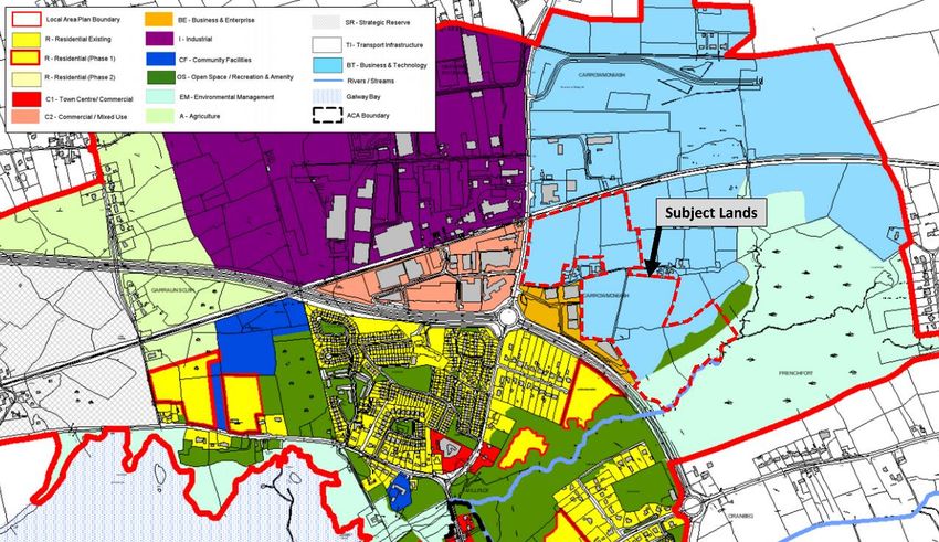
Lands at Carrowmoneash, Oranmore, Co. GalwayLands at Carrowmoneash, Oranmore, Co. Galway

     Table of Contents
1.   INTRODUCTION .................................................................................................................................. 2
     1.1             Preamble ...............................................................................................................................................................2
     1.2             County Development Plan Review .......................................................................................................2
     1.3             Site Specific Context .....................................................................................................................................2
     1.4             Proposed Rezoning ........................................................................................................................................2
2.   SUBMISSION TO THE DRAFT DEVELOPMENT PLAN ............................................................ 4
     2.1             Strategic Location of the Subject Site ............................................................................................... 4
            2.1.1             Access to National Road Network ............................................................................................................ 4
            2.1.2             Regional Markets, Producers and Supply Chain ................................................................................ 5
            2.1.3             Demand Pressures of Galway Metropolitan Area ............................................................................ 5
     2.2             Driving Factors for Change of Zoning ................................................................................................ 6
            2.2.1             Limited Development over the life of the Local Area Plan .......................................................... 6
            2.2.2             The Impact of Britain’s Exit from European Union (Brexit) .......................................................... 6
            2.2.3             Post- COVID-19 Resiliency & Climate Change ................................................................................... 7
            2.2.4             Improvements to Road Access (Regional and Local) ..................................................................... 8
                    2.2.4.1       The opening of the M17/ M18 -Tuam to Limerick Motorway ........................................................................ 8
                    2.2.4.2       Part 8 – Station Road (R381) Improvement Works ............................................................................................ 8
     2.3             Proposed Zoning Change .......................................................................................................................... 9
            2.3.1             Existing Zoning and Land Use of the Subject Site ............................................................................ 9
            2.3.2             Proposed Draft Zoning and Land Use of the Subject Site .......................................................... 10
     2.4             Regional Growth & Employment .......................................................................................................... 11
            2.4.1             Athenry Economic Corridor ......................................................................................................................... 11
            2.4.2             Atlantic Corridor – West to South-East ............................................................................................... 12
3.   CONCLUSION .................................................................................................................................... 13

     TABLE OF TABLES
     Table 1-1 Land Use Zoning Matrix for BT-Business & Technology ......................................................................................... 9
     Table 1-2 Land Use Zoning Matrix for BE-Business & Enterprise .......................................................................................... 10

     TABLE OF FIGURES
     Figure 1 Aerial View of the Subject Site (outline in red) ............................................................................................................. 3
     Figure 2 Ordinance Survey Map of the Subject Site (outlined in red ...................................................................................... 3
     Figure 3 All Island Illustration of Road Access .............................................................................................................................. 4
     Figure 4 Aerial View of the Subject Site 2000 -2012 ..................................................................................................................... 6
     Figure 5 Existing Zoning of the Subject Site (outlined in red) ................................................................................................... 9
     Figure 6 Draft Zoning of the Subject Site (outlined in red)....................................................................................................... 10
     Figure 7 Core Strategy of the Draft Galway County Council Development Plan 2022-2028........................................... 12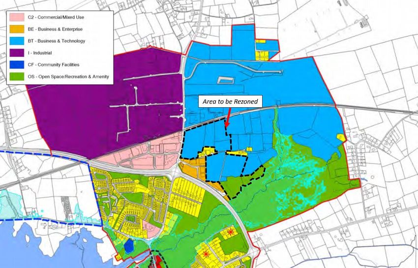
Lands at Carrowmoneash, Oranmore, Co. GalwayLands at Carrowmoneash, Oranmore, Co. Galway
1. INTRODUCTION
1.1 Preamble
MKO have been appointed by Sean McDonnell, Mary Dooley and Helen Staunton to prepare a
submission to Galway County Council on the Draft County Development Plan 2022-2028.
This submission relates to Lands at Station Road, Oranmore, Co. Galway, adjacent to Oranmore Business
Park and Deerpark Industrial Estate. This submission is laid out in accordance with the following key
points, which we respectfully ask that Galway County Council take cognisance of in their preparation of
the Draft County Development Plan:
Strategic Location of the subject Site;
Factors Influencing Change of Zoning;
Existing and Draft Zoning of the Subject Site; and
Changing landscape of employment, logistics and regional access.
There is an opportunity within the emerging Development Plan to recognise the changing requirements
of lands designated for various forms of employment and industry. The following submission has been
informed by the National Planning Framework, the Regional Spatial and Economic Strategy for the North
and Western Regional Assembly, Local Authority Plans and with an eye to the National Development
Plan and Climate Action Plan (2019).
1.2 County Development Plan Review
In accordance with Parts 9 and 11 of the Planning and Development Act 2000 (as amended) Galway
County Council are obligated to make a development plan every 6 years and open the draft plan to
public consultation during the process. The Galway County Development Plan 2022-2028 is currently in
its second (Draft Plan) stage of review; the public consultation of which is currently taking place from 20 th
May 2021 to 30th July 2021. This report forms the basis for a submission to the draft plan review. Our
client is taking a logical approach towards the planning and development of Galway County. Such an
approach is key to ensuring that suitable lands are developed in the most efficient and sustainable manner
feasible, to enhance tourism and the heritage of the area, and to meet the aims and objectives of national
and regional policy and guidance of the same.
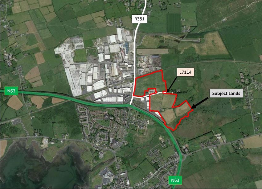
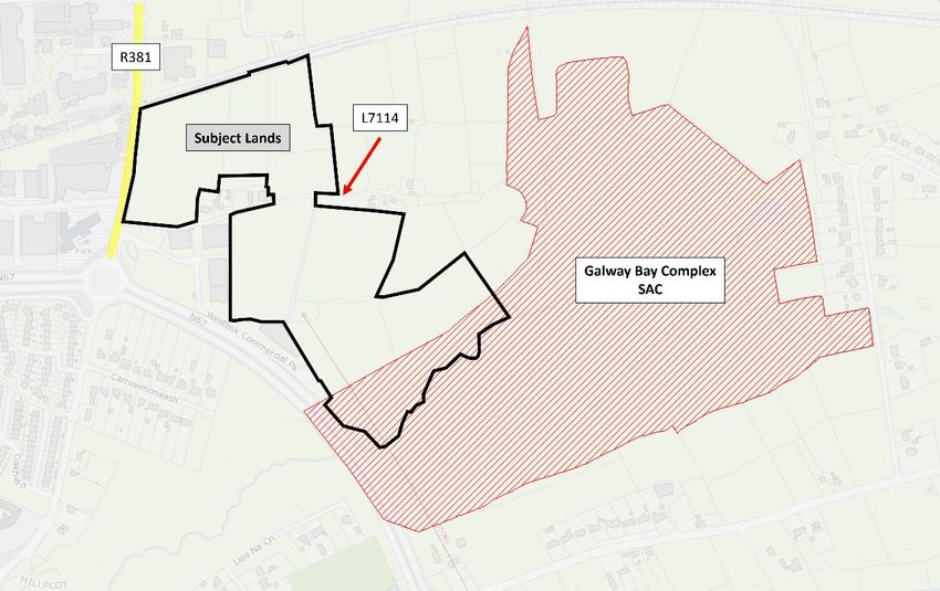
1.3 Site Specific Context
The subject site is located to the east of the Claregalway Road (R381) and has access from a laneway to
the north (L71114). The subject site is circa 12.09 Hectares in size and is currently underutilised as farm
land, but is currently zoned as Business and Technology, OS - Open Space and A - Agriculture in the
Oranmore Local Area Plan 2012-2022.
1.4 Proposed Rezoning
On behalf of our client, Sean McDonnell, we respectfully request that the subject lands are zoned
‘Business & Enterprise’ in the adopted Galway County Development Plan 2022-2028.
The rationale and justification for this rezoning is set out in the Sections below.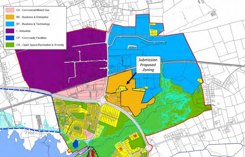
Lands at Carrowmoneash, Oranmore, Co. GalwayLands at Carrowmoneash, Oranmore, Co. Galway

Figure 1 Aerial View of the Subject Site (outline in red)

Figure 2 Ordinance Survey Map of the Subject Site (outlined in black)
Lands at Carrowmoneash, Oranmore, Co. GalwayLands at Carrowmoneash, Oranmore, Co. Galway
2. SUBMISSION TO THE DRAFT
DEVELOPMENT PLAN
2.1 Strategic Location of the Subject Site
The subject site is strategically well located with short journey times to the N67 (Galway to Moneypoint),
M6 (Galway to Dublin, M17 (Galway to Tuam) and M18 (Galway to Limerick) roads. This provides for
fast regional access to a number of important settlements, employers and supply chain industries and
logistics infrastructure.
The following sub-sections will set out how this high accessibility is more benefiting of the proposed
change of zoning to Business & Enterprise.
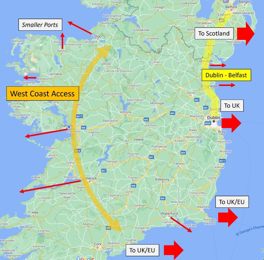
2.1.1 Access to National Road Network
Currently there exists an abundance of reliable road access in close proximity to the subject site. This
affords strong regional and national access to the motorway network, ports and the wider economy of the
island of Ireland.
Figure 3 All Island Illustration of Road Access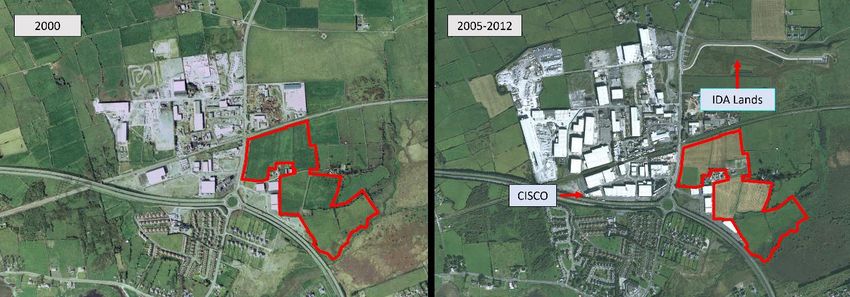
Lands at Carrowmoneash, Oranmore, Co. GalwayLands at Carrowmoneash, Oranmore, Co. Galway

        Due to the ease of access to the national road network the subject site is well placed to support businesses
        and enterprises which benefit employment not just in the metropolitan area or County, but also on a
        national and all-island basis.

2.1.2   Regional Markets, Producers and Supply Chain
        The Galway Metropolitan Area currently has a population of circa 80,000 people, this substantial urban
        population generates its own economic demands and an available workforce. The Galway City
        Metropolitan Area and surrounding areas of employment have attracted a significant range of employers
        including in the Information Technology, Pharmaceutical and Medical Technology sectors. This
        concentration of employers also generates a demand for consumer goods, component parts and other
        ancillary supply chain demands.

        Given the unique demands of these industries it is envisaged that there exists scope and demand for an
        expansion of complementary uses within the Oranmore area. The subject site is well placed to provide
        for a range of use options which in our opinion are better suited by the rezoning of these lands to Business
        & Enterprise zoning.

2.1.3   Demand Pressures of Galway Metropolitan Area
        Galway City as a significant urban centre which has been targeted as one of the 5 no. cities of the National
        Planning Framework for population and employment growth requires its own localised warehousing,
        bulk goods handling, wholesales and flexible space for emerging and innovate enterprises.

        The proximity of the subject site to a range of commercial, industrial and specialised employers creates
        a market for complimentary businesses and competitors. The degree of flexibility offered by potential
        rezoning therefore is more capable of absorbing and catering to this demand than the current Business
        and Technology zoning which is more specialised towards larger scale employers.

        As the city region continues to grow there will also be a growth in the need to service the commercial
        and employment function of the city through ancillary activities, producers and logistics operations. By
        moving away from land use that is overly specialised or calls for higher density offices and production
        facilities, the subject lands will be able to provide a degree of flexibility and adaptability over the life of
        the next Development Plan.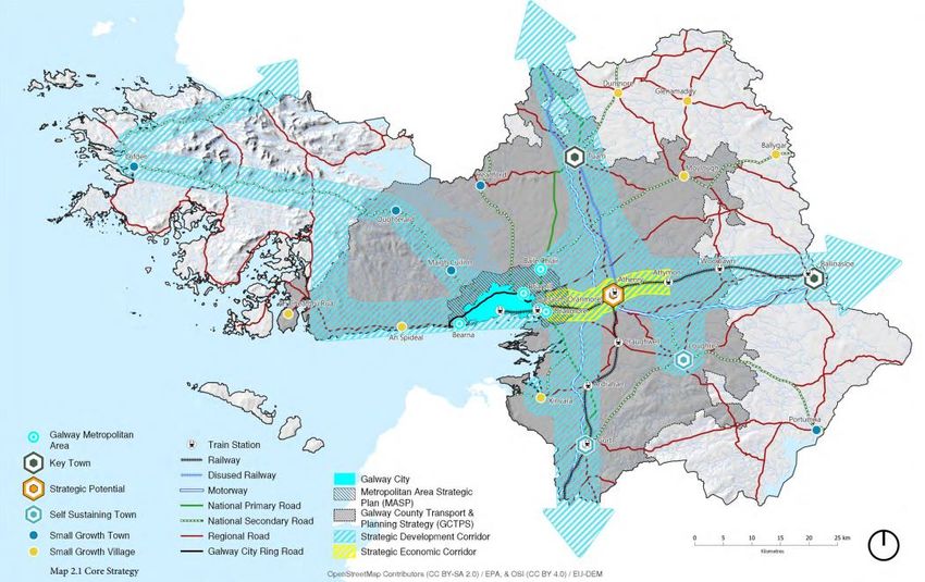
Lands at Carrowmoneash, Oranmore, Co. GalwayLands at Carrowmoneash, Oranmore, Co. Galway

2.2     Driving Factors for Change of Zoning
2.2.1   Limited Development over the life of the Local Area
        Plan
        There is no recent planning history which has taken place within the subject site. The following is an
        aerial history of the subject site and surrounding lands demonstrating the slow change in the creation of
        industrial and enterprise activities at the turn of the century and in comparison, to the existing activity as
        seen in Figure 1 above.

        Figure 4 Aerial View of the Subject Site 2000 -2012

        It is also worth noting that the dedicated and serviced IDA Campus to the north has yet to be occupied
        by any employer. Many of the surrounding lands have not been serviced or provided such high-quality
        infrastructure. Yet, to date there has been no major anchor employer which has taken the opportunity to
        occupy these lands and develop new dedicated facilities. These lands are ostensibly “ready-to-go” yet
        they have not been occupied, it is therefore conceivable that there is an over-concentration of this zoning
        type in the vicinity given the low level of investment and development of available sites.

        The subject lands could, subject to a successful rezoning, attract complimentary and comparable
        employers to those found directly to the south in the Westlink Commercial Park. These lands to the south
        have been zoned Business & Enterprise and this submission generally seeks the expansion of this zoning
        into the subject site.

2.2.2   The Impact of Britain’s Exit from European Union
        (Brexit)
        In 2016 the United Kingdom of Great Britain and Northern Ireland (the UK) voted via referendum to
        leave the European Union (EU), known as colloquially as Brexit. Following a long and protracted
        negotiation processes the UK officially exited the EU in early 2020. After a grace period of 1 year the
        final withdrawal agreement and the provisions of the ‘Northern Ireland Protocol’ came into effect at the
        beginning of 2021. This period has seen a significant shift in the operation of trade and goods movement
        between the Republic of Ireland, Northern Ireland and mainland Britain.

        A de facto EU border exists in the Irish sea, which sets a degree of regulatory and trade differences
        between Northern Ireland and Great Britain. In order to uphold the provisions of the Good Friday
        Agreement and maintain the peace process, the parties of the withdrawal agreement signed up to the
        ‘Northern Irish Protocol’ which has established this new trade relationship and change to customs
        inspections.

        This shift in trade has meant that certain goods, products and services can no longer avail of the land-
        bridge across the UK in order to enter the island of Ireland from continental Europe. In order to maintain
Lands at Carrowmoneash, Oranmore, Co. GalwayLands at Carrowmoneash, Oranmore, Co. Galway
supply chain operations a number of sectors and industries in the Republic of Ireland have availed of a
shift in transport options to new sea route connections to Europe. These new sea crossings have especially
increased the traffic passing through the ports of Cork and Rosslare; with connections to France and the
Netherlands attracting the most significant growth in freight during this period.
Where the subject lands may be able to play a significant role is in the latter stage distribution and storage
of goods entering the markets and industry of Galway City and the wider Northern and Western Region.
The strong road connections of the subject site can provide for an ease of access to end users as well as
potential customers.
In order to better manage freight movements, and changes in the economy, the subject lands are well
suited to a change of zoning which can facilitate the associated land uses and employment opportunities
which can address these recent changes in the economy and trade routes.
2.2.3 Post- COVID-19 Resiliency & Climate Change
As the past number of years have demonstrated, not only has the economy had to adapt and respond to
the unique challenges of the Brexit process, but also to a global pandemic. The significant economic,
social, transport and logistical challenges that the Covid-19 pandemic generated contributed to a notable
increase in the use of online retail, as well as an increase in remote working.
It is with an eye to adaptation for changing work environments and a shift in the lifestyle of the workforce
that it is conceivable that the quantity of lands zoned for “Business & Technology” is no longer required
on the subject lands. There is also likely to be a rise in work from home and remote working hubs as the
availability of technology and infrastructure related to broadband and 5G networks expands throughout
the County and Region.
One particular aspect of the pandemic response which has put pressure on existing infrastructure and
supply chains is the rise of online retail and commerce. This has increased significant demand on the
existing courier’s, postal services and logistics operations of large-scale retailers, as well as further
distributed the delivery locations of such goods. This shift away from traditional retail activity has been
an ongoing trend, however the scale and shift to online shopping during this period has put many systems
under strain and has required additional capacity in warehousing, distribution and last mile/kilometre
handling.
The future of freight and goods handling in urban centres may require a shift to more sustainable modes
of travel, as well as reducing the quantity of goods handled by each vehicle. It is now less likely that
freight movements will be handled by a singular container/trailer leaving a wholesalers/warehouse and
travelling directly to the end user.
This form of freight transport was particularly more common before Brexit owing to the availability of
“roll-on-roll-off” sailings and the UK land-bridge. This could see containers move from continental Europe
to the Island of Ireland with just in time frequency and adaptive response from businesses. The extended
length of travel time to Europe will now necessitate additional capacity for businesses to distribute and
store goods and components as travel times and available routes have been significantly altered.
In response to a distributed customer base and changes in available transport there will be a need for
local and regional logistics activities and businesses which can transfer goods and repackage/combine
shipments in response to localised demands.
The extended periods of lockdown and restrictions enforced upon the nation in order to mitigate the
effects of the Covid-19 pandemic contributed to a precipitous decline in commuting, air pollution and
saw improvements in work-life balance and individual spending power. The long term effects of this shift
in working culture over more than 18-months is likely to further change the demand for centralised offices
or large workforces co-locating within the same specialised campuses.Lands at Carrowmoneash, Oranmore, Co. GalwayLands at Carrowmoneash, Oranmore, Co. Galway
There were also significant environmental benefits to the lockdown period locally and globally with some
reductions in air and water pollution as traffic declined and some industrial activities paused production.
As we adapt to changes in the economy, workforce and industrial practices following this extended
pandemic related change, we also face the coming challenge of climate change. The further adaptation
of our carbon emissions practices, energy demand and commuting patterns is likely to see a shift in the
demand for the type of employers envisaged for “Business & Technology lands”.
2.2.4 Improvements to Road Access (Regional and Local)
2.2.4.1 The opening of the M17/ M18 -Tuam to Limerick Motorway
The combined roads of the M17 and M18 form part of the “Atlantic Corridor” which formed part of a
program of investment in the road network of the west of Ireland to provide links from Donegal along
the settlements of the west and connecting onward to the south-east. The completion of these two roads
in September 2017 has greatly improved regional access to County Mayo and County Sligo via Tuam,
and to County Clare, Shannon Airport and Limerick City and County.
These road projects were completed following the establishment of the current Oranmore Local Area
Plan 2012-2022 and therefore the existing zoning provision does not adequately address the potential
afforded by this level of regional connectivity. As will be discussed in Section 2.3 below there has been
little material change to the quantum of “Business & Technology” lands zoned within the subject site and
surrounding properties.
2.2.4.2 Part 8 – Station Road (R381) Improvement Works
Adjacent to the subject site is a historic long term goal to improve the R381 utilising a Part 8 scheme by
the council under Ref. LA2506 which was granted permission in 2006.
This Part 8 scheme will see improvements to the road layout and new footpaths connecting the nearby
disparate industrial and employment uses. This scheme also will provide a new roundabout c. 700 metres
to the north which will improve upon junction connection to the Deerpark Industrial estate and the
surrounding rural roads, further opening up landholdings to the norther for development.
To date upgrades to the R381 (formerly N18) have mostly been confined to resurfacing and lane layout
changes in recent years following the completion of the M18 motorway further to the east. It is envisaged
that the continued demand placed on this road will eventually see the need for this roundabout fulfilled
and potential changes to the Galway-Portarlington railway level crossing also.Lands at Carrowmoneash, Oranmore, Co. GalwayLands at Carrowmoneash, Oranmore, Co. Galway
2.3 Proposed Zoning Change
2.3.1 Existing Zoning and Land Use of the Subject Site
Under the current Oranmore Local Area Plan 2012-2022 (as extended) the subject site is zoned BT-
Business & Technology, this also includes a sliver of OS - Open Space, and land zoned A-Agriculture
which coincides with the Galway Bay Complex SAC.
Figure 5 Existing Zoning of the Subject Site (outlined by dashed red line)
The following uses are Permitted in Principle and Open for Consideration within the zoning BT- Business
& Technology:
Table 2-1 Land Use Zoning Matrix for BT-Business & Technology
Types of Consent Land Use Matrix
Permitted in Principle Data-Centres/Web-hosting Centres, Office (100 sq m to 1,000 sq m), Office
Park (>1,000 sq m), Science and Technology Based Business.
Open for Consideration Advertisements -freestanding, ATM*, café*, car park*, car park multi-
storey*, childcare facilities (crèche/nursery), conference centre, education
– other educational training facility, enterprise centre, logistic, storage &
distribution units, media recording & general media associated uses, park
& ride facility*, storage depot, utilities infrastructure & public service
installations, and renewable energy*.
* Ancillary to an overall compatible development.
Over the life of the current Local Area Plan for Oranmore none of the Permitted in Principle or Open
for Consideration uses have been developed on the subject lands and adjacent sites, including the IDA
lands to the north which have been specifically serviced for high-intensity employment.Lands at Carrowmoneash, Oranmore, Co. GalwayLands at Carrowmoneash, Oranmore, Co. Galway
2.3.2 Proposed Draft Zoning and Land Use of the Subject
Site
Under the Draft Galway County Development Plan the subject site has been partially rezoned to reflect
the presence of private residences and assorted outbuildings associated with historic agricultural practices.
It is however the long-term viability and success to date of the BT- Business & Technology zoning which
is of most concern to our client as there has been little activity to date, even where sites are serviced and
set up to attract employers. There is also a proportion of the site which under the draft plan has been
rezoned as OS -Open Space/Recreation & Amenity. This portion of the site is not within the Galway Bay
Complex SAC or the flood risk land constraints to the south. It is therefore proposed that this land also
be included as part of the rezoning to BE – Business & Enterprise.
The following is the Draft Zoning, with the area of proposed rezoning outlined by a dashed black line:
Figure 6 Draft Zoning of the Subject Site (outlined in red)
Under the proposed change of zoning to BE - Business & Enterprise the following land uses would apply.
Table 2-2 Land Use Zoning Matrix for BE-Business & Enterprise
Types of Consent Land Use Matrix
Permitted in Principle Conference Centre, Data-Centres/ Web-Hosting Centres, Enterprise
Centre, Media Recording & General Media Associated Uses, and Science
& Technology Based Business.
Open for Consideration ATM, Café*, Cash & Carry, Garden Centre, GP & Medical Related
Services, Household Fuel Depot, Industrial, Logistic, Storage &
Distribution Units, Motor Sales Showroom, Office (1,000 Sq M), Service Garage,
Small Scale Manufacturing, Storage Depot, Transport Depot, Veterinary
Surgery, Warehousing (Incl. Wholesale), Warehousing (Retail/Non-Lands at Carrowmoneash, Oranmore, Co. GalwayLands at Carrowmoneash, Oranmore, Co. Galway
Food/Bulky Household Goods 700 Sq M – 5,000 Sq M), Buildings for the
Health, Safety & Welfare of the Public, and Childcare Facilities (Crèche/
Nursery).
* Ancillary to an overall compatible development.
It is our opinion that the proposed land uses are more suitable for the subject site owing to the inability
of surrounding sites to attract the types of uses currently contained within the BT- Business & Technology
zoning. This also includes the area of open space land which is not within the constrained land use area
or the Galway Bay Complex SAC.
While some uses are comparable there is a degree of flexibility within the open for consideration uses
which are considered to be more applicable to the subject site and may attract more employment and
economic activity to the vicinity.
Figure 7 Proposed Rezoning of the Subject Site
As seen above in Figure 7, following the proposed rezoning the following would be the resulting zoning
map for the subject site. It is our opinion that this is the optimum and suitable zoning use applicable to
the subject site.
2.4 Regional Growth & Employment
2.4.1 Athenry Economic Corridor
As part of the Draft County Development Plan and in line with the Regional Spatial and Economic
Strategy there is a proposed ‘Strategic Economic Corridor’ between Galway City and Athenry. Owning
to the concentration of road and public transport infrastructure along this corridor there is a significant
opportunity for seizing upon this connectivity for economic and population growth.
Oranmore sits comfortably within this corridor with connections north to Baile Chláir (Claregalway) and
south to Gort and other smaller towns. This means that the high concentration of industry, enterprise andLands at Carrowmoneash, Oranmore, Co. GalwayLands at Carrowmoneash, Oranmore, Co. Galway
employment around Oranmore is well placed to link to the surrounding region via the national road
network as well as regional and local roads.
Figure 8 Core Strategy of the Draft Galway County Council Development Plan 2022-2028
The strategic location of the subject site between important road junctions with the M6 motorway and
the wider region provides for ample connectivity and scope for attracting employers and activity which
can capitalise on this infrastructure and contribute to the wider economy of the County and Region.
2.4.2 Atlantic Corridor – West to South-East
A legacy of the Transport 21 project from 2005 is the establishment of an “Atlantic Corridor”
encompassing road and infrastructure upgrades along the west coast of Ireland and connecting onward
to the South-East via Waterford and Rosslare Europort.
To date motorway access from Tuam to Limerick has been completed via the M17/ M18. There is also
ongoing consultation on the potential route options for the M20 Limerick to Cork motorway. Elsewhere
a number of important road upgrades and bypasses have also been completed in recent decades
including the New Ross bypass (N25) and the Enniscorthy bypass (N30) which have improved
connections to the south-east between Waterford and the M11 (Rosslare to Dublin).
There are a number of other town linkages that are part of the current National Development Plan and
programme of roads projects, including the Tipperary bypass, which will complete much of this original
corridor.
It is conceivable that the national road network under the National Planning Framework and current
National Development Plan is capable of supporting a logistical shift to the ports of Galway, Foynes
(Limerick), Cork/ Ringaskiddy, Waterford and Rosslare ports in response to wider economic forces such
as Brexit, the growth of cities outside of Dublin, and given the limitations and capacity constraints on
Dublin port.
The subject site is well connected and capable of supporting a wide range of economic functions which
are capable of taking advantage of this strategic location and contributing to the economic growth of
Galway City and County.Lands at Carrowmoneash, Oranmore, Co. GalwayLands at Carrowmoneash, Oranmore, Co. Galway
3. CONCLUSION
It is our submission that our clients lands are better served by a rezoning from BT – Business &
Technology (including a smaller area of OS -Open Space/ Recreation and Amenity) to BE – Business &
Enterprise. There is a greater scope for flexibility and comparable investment to adjacent lands under
this potential rezoning. This is especially the case owing to the lack of inward investment on BT- Business
& Technology lands, even when sites are well serviced and primed for investment and development. In
summary the key points addressed by this submission are as follows:
The strategic access of the subject site to the national road network including the M6, M17,
M18 and N63;
There is a shift in the needs of industrial, logistics and enterprise zoned lands in response
to Brexit, Covid-19 and Climate Change resiliency;
The subject site is capable of supporting the goals of the Athlone to Galway Strategic
Economic Corridor;
There has been no significant development of BT-Business & Technology zoned lands in
the vicinity over the course of the current Local Area Plan (2012-2018 as extended);
There are comparable land uses amongst the Permitted in Principle uses between the two
zonings;
Under the Open for Consideration uses there is a degree of flexibility that the subject site
could benefit from and compliment adjacent developments;
The subject site is well located to provide support for the goals of the Draft Galway County
Council Development Plan 2022-2028 and the Regional Spatial and Economic Strategy for
the Northern and Western Regional Assembly.
It is under this emerging economic climate and Development Plan policy that the subject site in our
considered opinion can successfully support a change in land use zoning that is responsive to evolving
needs and flexible enough to adapt and change over the life of the new plan. We request the at subject
lands as identified in Figure 7 should be zoned BE – Business and Enterprise in the adopted development
plan.
We trust that the above submission will be given due consideration in the preparation of the Galway
County Development Plan 2022-2028.You can also read