Enabling Efficient Government with Location-Centric CRM
←
→
Page content transcription
If your browser does not render page correctly, please read the page content below
WHITE PAPER

Enabling Efficient Government
with Location-Centric CRM
Table of Contents
CRM in Government                                          2

The Need for Location-Centric CRM                          2

Why Leverage GIS?                                          3

Location-Centric CRM Drives Government Efficiency          4

Motorola’s Government CRM Solution Enables Unmatched       4
Location Processing

How It Works                                               5

Key Benefits of Location-Based CSR                         6

The CSR Experience…Why Location Processing is Essential    7
for Government CRM

Motorola CSR…Using Location To Deliver A Higher Standard   11
of Government Service to Your Citizens
Challenged with meeting the high expectations of citizens, government officials
search for solutions to automate response and standardize the level of services.
Forward-thinking government agencies implement Customer Relationship
Management (CRM) systems to manage citizen inquiries, optimize service
delivery, automate workflow, and improve accountability.

CRM in Government
Several trends currently drive CRM programs for all levels of government (local, state, and federal), including:

•   The Citizen’s demand for better services
•   Achieving Citizen-Centric government without fear of Big Brother
•   Streamlining government service delivery for improved response
•   Expanding accountability back to the public for more transparent government
•   Reducing government inefficiency and costs, while increasing revenue opportunities to demonstrate
    fiscal responsibility

Government CRM systems capture service request details, route the request to the proper agency, track
workflow progress, and measure performance. This coordinated approach helps to improve agency efficien-
cy and bridge municipal silos. In fact, CRM transforms the way government does business. Case after case
proves the cost savings and increased citizen satisfaction that CRM achieves when properly implemented.

However, not all CRM systems match government requirements. Fundamental differences exist
between CRM systems derived from private sector architectures, and systems designed specifically for the
public sector.

Commercial CRM uses a consumer-centric approach, focusing on acquiring and retaining customers through
data capture to enhance customer retention—with the goal of a 360-degree view of the consumer.
Private sector business needs drive commercial CRM product development to guarantee that features meet
marketing, sales, and long-term customer loyalty requirements. Commercial CRM uses a private sector,
consumer-centric data model.

In contrast, government CRM requires a location-aware approach. A successful government CRM system
requires a data model that supports the “way” and “how” government responds to citizens. For all levels
of government, the location of the issue and the agency responsible for that location determines the “way”
and the “how”.

    What does “Built for Government” Mean?
    Commercial CRM                                           Government CRM
    Customer-Centric Features Include:                       Citzen-Centric Features Include:
    • 360º view of consumer buying habits                    • Citizen access
    • Sales force automation                                 • Respects citizen privacy
    • Sales order entry                                      • Government service request and delivery
    • Mobile sales                                           • Workforce management
    • Billing                                                • Correspondence
    • Product delivery                                       • Reporting and performing management
    • Vendor management                                      • Workforce mobility
    • Product warranty and repairs                           • Data model built around the government
    • Data model built around marketing/sales

The Need for Location-Centric CRM
At any level of government, location is fundamental to how agencies operate and respond to their citizens.
Government agencies are organized by jurisdiction and districts—each with unique needs, services, and
regulations. The way an agency processes information requests, service intake, task routing, work
fulfillment, resource management, and performance accountability changes based on the jurisdiction
and geography.

2 WHITE PAPER Location Centric CRM
From the citizen’s perspective, interaction with government usually takes the form of information or service
requests: Whom should they call for streetlight maintenance, pothole repairs, school closings, closest
shelter or food bank, and hundreds of other request types that citizens require from government? Even
though each request may seem minor, collectively the issues add to the perception that government either
“works” or does not “work”.
Whenever a government call center (such as 9-1-1, 3-1-1, or 2-1-1) receives a citizen call, call response and
follow up resource assignments are based upon a geographical reference—specifically, a location-centric
reference. Service and information requests have critical geographical data associated with them. Location
validates that the caller is requesting information or a service provided within the jurisdictional region of
responsibility. If the location is not accurate or unavailable to the CRM system, the following can occur:
• Callers become frustrated because they know they are providing the correct address, but the Call Center
cannot verify the address
• Work orders print with incorrect service locations, which result in crews unable to find the correct
destination
• Abandoned or lost service requests
• Inaccurate work assignments due to incorrect jurisdictional boundaries
• Duplicate service calls for the same issue
Geographical servicing becomes even more important during support of Homeland Security and disaster
events. In these critical scenarios, rapid and adequate response to affected citizens demands multi-jurisdic-
tional collaboration between all levels of government. In multi-jurisdictional coordination, effective response
requires an understanding of responsibilities by task and locality.
Given that government response is location-based, effective application of government CRM requires a data
model that supports the way government serves the public—geographically. Because jurisdictions must
focus on events, locations, and service delivery patterns, the optimal solution for government is a CRM
system built around a data model that fully leverages Geographical Information Systems (GIS).
A CRM solution used in combination with a department’s existing investment in GIS brings logic and
efficiency to managing a wide range of requests for government services.
Why Leverage GIS?
GIS benefits all levels of Many government Information Technology (IT) departments have spent significant resources on GIS
government including: databases for a wide range of collection, analysis, and management tasks. Applications that leverage GIS for
• Homeland Security business applications, in addition to analytics, can rapidly capitalize on the power of GIS.
and Defense
• Emergency Response With GIS, departments link location information to multiple types of data like buildings, addresses, streets,
and Recovery and resource zones. Because GIS data is spatial (consisting of points, lines, and polygons defined by
• Public Health and Safety geographic coordinates), this data maps where the service delivery events occur in relation to where the
• Land Datasets and
resources exist. As a result, government departments can:
Property Assessment
• Public Works
• Urban and Regional
• Map locations of events, services and resources • Locate features on a map
Planning • Discover patterns within the distribution of features • Determine what is inside a region or boundary
• Economic • Record quantities, densities and changes in • Route resources and assign work based on
Development geographic features over time geographical utilization
In a government CRM system integrated with GIS, detailed location information drives the end-to-end
business process. Location-centric CRM fully leverages GIS parameters to optimize business workflow
automation and mapping of citizen service requests. As a result, the CRM system runs analysis based on
where the issue exists, who owns the issue, and who should receive the issue. Government at all levels can
use this information to manage human and environmental resources, extract trend data, and build
knowledge databases.
Every government service category benefits from a geographic context:
• Abandoned Vehicles • Code Violations
• Flooded Basements • Tax Assessments
• Broken Sewer Mains • Commercial, Residential and Environmental Zoning
• Streetlight Outages • Tracking of Disease Outbreaks
3 WHITE PAPER Location Centric CRMThrough location-centric CRM, government can coordinate optimal citizen response across all levels of government and proactively analyze community trends to take action preemptively. Location-Centric CRM Drives Government Efficiency Using the geospatial processing capabilities provided by GIS, a vast range of holistic benefits become available to government CRM. In fact, CRM integrated with GIS improves the entire service delivery workflow through an enterprise view of citizen requests. The ability to assign locations to events is just one of many benefits of having tightly coupled GIS integration. The real power dwells behind the large amount of data accessible through the CRM system, both current and historic in nature. Public Managers throughout all levels of government can analyze this central repository of data, allowing them to focus on decision-making and performance management. By using GIS trends and geographical analysis coupled with a CRM workflow, agencies can reallocate resources based on need and predict trends to solve problems proactively—significantly increasing efficiency in government service delivery processes. Location-Centric CRM at Work in the Community Imagine visualizing where service events occur on a daily basis. Through location processing, managers can retrieve events based upon historic trends—with validated addresses, corridors, or areas placed on a digital reference map. With this capabil- ity, the Public Works Department could map occurrences of broken sewer mains. Land Use Planning could map code violations and analyze where rezoning should take place. In addition, they could map zones with high rubbish concentrations and allocate additional funds for neighborhood clean-up projects. The Public Health Department could monitor, track, and develop strategies to contain the spread of disease like West Nile virus through a region. Additionally by associating location parameters to work requests and processes, preemptive intelligence is available to alert personnel of possible dangers. For example, in a 24-hour span, if more than five citizen requests are received to investigate the presence of a suspicious vehicle within 500 meters of a school, an alert is triggered to the police department. In another example, the Department of Transportation could efficiently route work crews to the mapped locations of streetlight outages called in the day before, and reallocate the crew to target specific areas, real-time. Using location-based routing of mo- bile work crews, work assignments are sent to the closest available crew. During trend analysis, transportation planners could visualize areas with high accident rates retrieved from historic information in the CRM, providing detailed information to improve traffic light timing and budgeting for road expansion. Motorola’s Government CRM Solution Enables Unmatched Location Processing With over 70 years of experience in the government market, Motorola understands the unique needs of the government business model. Motorola translated this knowledge into a Government CRM solution embedded with ESRI’s GIS software, expanding the capabilities of our industry leading Customer Service Request (CSR) system to fully leverage the power of GIS. CSR is a government CRM software application built upon a location-centric data model that provides front-end functionality for government Call Centers, as well as back-end workflow for Departmental Service Delivery. CSR captures, tracks, and manages the work required to respond to requests from citizens and departments through web-based technologies. The CSR application supports government service delivery and work order management by using a unique, three pronged approach to decision-making: • Location-based: Where is the problem? • Service request type: What is the problem? • Customer reference: Who is calling? Motorola’s unique approach to CRM transforms the way that government responds to citizens while optimizing the end-to-end, intake through resolution processes of government constituent response. 4 WHITE PAPER Location Centric CRM
“Embedding ArcGIS in Motorola’s Customer Service Request system extends
GIS capability to more government service providers; it helps make government
more responsive and reliable. GIS helps to improve the quality of service
delivered by government and strengthens communication between citizen and
government throughout the entire lifecycle of the service request.”
Christopher Thomas, ESRI’s Government Industry Solutions Manager

To leverage the power of location processing, Motorola teamed up with the thought leader in GIS
expertise—ESRI®, Inc. Integrated with ESRI’s ArcGIS® server technology, CSR relies on the customer’s
existing infrastructure data enabling a direct interface with government GIS. In addition, configuration of
CSR’s spatial database occurs simply by using standard ESRI tools, eliminating the need for costly
proprietary processing.

 The Power Behind ESRI’s ArcGIS
 GIS goes beyond mapping software. ESRI’s ArcGIS enables users to deploy GIS functionality wherever it is needed—in
 desktops, servers, or custom applications; over the Web; or in the field. Not only does ArcGIS provide powerful visualization
 and cartographic mapping tools for business and scientific use, it includes a complete set of tools that:

 •   Automate workflows through a visual modeling environment
 •   Optimize agency resource allocation
 •   Discover and characterize geographic patterns
 •   Predict potential outcomes based on historical patterns

 ArcGIS is a comprehensive management system for geographic information. ArcGIS Server enables organizations to dynamically
 fuse information from multiple data sources, servers, and business systems throughout the enterprise for use by analysts,
 decision makers, and mobile workers.

The CSR/GIS integration strategy evolved from Motorola’s experience with large government agencies and
their unique GIS requirements. As a result, CSR users can maximize their ROI in GIS and CRM—bringing
logic and efficiency to managing a wide range of request scenarios for government services.

How It Works
With CSR, customer service begins in the call center. The intake process takes place through the multiple
channels that citizens use to contact government such as the internet, calls from home or work, and mobile
phones. The call center uses CSR to create a service request. Then, the system validates the request against
a GIS map address, and determines possible courses of action using intelligent business rules.
To eliminate the chance of duplication, CSR verifies the authenticity of the new request based upon user-
defined thresholds.

Customer service, however, is delivered by government service delivery departments. CSR enables
end-to-end customer service by automatically routing the service request to the appropriate jurisdiction and
department for accountable issue resolution. The system performs a proximity check against the GIS data
to determine the availability of resources. With live geographical data representing all services, the system
spatially stores and regularly updates the information. Management can then map CSR’s data into a logical
presentation for trending and analysis, enabling efficient Performance Management.

CSR allows all levels of government to visualize their GIS data, providing accurate locations and layered,
spatial information such as council districts, infrastructure (roads, bridges, water/sewer systems), and flood
zones—all which already exist in agency GIS departments. Through this capability, CSR automatically
assigns service requests to the correct department—simplifying processing, scheduling and routing of
service requests, and their ultimate delivery.

5 WHITE PAPER Location Centric CRM
Motorola’s CSR is a proven, location-centric CRM solution that addresses the
challenges government managers face today.

Key Benefits of Location-Based CSR
Designed from the ground up for government and GIS, CSR uses location processing and mapping to focus
on the service type and the jurisdiction of the request.

Optimized for Government
CSR use a tightly coupled, location-centric data model designed specifically for the way government delivers
services. This is in direct contrast to consumer-centric systems modified for government use.

Enterprise-Driven Management
GIS data and location processing makes possible end-to-end management of the citizen request—from
the intake process through resolution—all integrated with call center, knowledge base, and workflow
functionality to most efficiently allocate resources and effectively respond to citizens.

Multi-Agency, Multi-Jurisdictional Support
Location-based processing helps remove barriers between citizens and government. CSR can filter
information and validate issues based on where the problem is. Not only can a citizen receive timely and
relevant information during their initial contact, CSR’s ability to assign ownership based on the service
district improves government accountability.

Knowledge Management
Because 60-70% of calls from citizens contain “information only” requests, knowledge management
becomes critical in government CRM. To provide rapid access to accurate information, CSR contains a fil-
tered knowledge base that reports information back to the citizen that is only relevant to their jurisdiction.

Multiple Layers of Spatial Data
CSR goes beyond simple address and location validation. For example, users can query distance parameters
such as single point, area, and corridor during duplication checking for that region.

Empowers the Citizen
CSR gives citizens the power of location processing, making the citizen more efficient during web-based
information searches. In this scenario, CSR filters information and processes service requests using valid
location data, the same as in the call center. This ensures that citizens receive the most appropriate
information, that departments capture service requests for valid locations within their jurisdiction, and that
the intake process verifies request data directly with the citizen.

Advanced Trending and Analysis Capability
CSR’s data model links directly to GIS datasets for mapping, trending, and analytics. This direct connection
to the spatial data both to the customer as well as back into CSR enables a GIS department to perform
additional analysis beyond what exists in the CSR system itself. Having this pointer maximizes the ROI of
the customer’s GIS infrastructure.

6 WHITE PAPER Location Centric CRM
The CSR Experience…Why Location Processing is Essential
                                  for Government CRM
                                  Efficient Call Handling Increases Citizen Satisfaction
                                  The purpose of government is to be accountable to the needs of the public. When it comes time to vote and
                                  establish budgets, citizens remember how well government performed. Citizens hold officials responsible
                                  when encountering layers of bureaucracy, like having to go through five departments just to request ser-
                                  vices for a litter-clogged storm drain. Cutting through silos of bureaucracy requires a location-aware approach
                                  to enable fast and efficient call classification, routing and processing.

                                  For each information or service request, CSR’s location filtering provides the most relevant and valid infor-
                                  mation to a call agent. This helps call centers quickly determine to which jurisdiction the problem requires
                                  routing, and who is responsible. Additionally, CSR uses duplicate service request checking to ensure that call
                                  takers route only the original request and allocate the appropriate resources for service resolution.

                                  Motorola’s CSR Enables the Nation’s First Multi-Jurisdictional 3-1-1 System
                                  More than 30 cities nationwide have 3-1-1 systems, whereby residents can call one phone number to
                                  access a variety of non-emergency city services. What is unique about Miami-Dade’s 3-1-1 system is that it
                                  provides callers with services that cross local governmental lines. Callers can request information about City
                                  of Miami services or those from Miami-Dade County departments by using the same 3-1-1 number. During
                                  the next several years, it is expected that the nearly 30 other municipalities within Miami-Dade County will
                                  join the system, thereby making obsolete the multitude of phone numbers that departments within those
                                  municipalities maintain.
“Citizen-Centric government
                                  Miami-Dade County alone has about 1,600 offices listed in the “Blue Pages” of the AT&T phone book,
can only be achieved when
the citizen doesn’t have to       leaving residents prior to September 2005 with a daunting array of choices when trying to figure out whom
figure out who to call.”          to call. With the release of the 2006-2007 phone books, there will only be 17 County phone numbers to
                                  choose from (the mayor, county manager, 13 commissioners, 9-1-1, and 3-1-1). For non-emergency service,
Judy Zito, Director of the
Government Information            residents can simply call 3-1-1.
Center (GIC), Miami-Dade County
3-1-1 Answer Center
                                  Motorola’s CSR system, the intelligence behind many other 3-1-1 call centers nationwide, was the solution.
                                  Because of its multi-jurisdictional nature, Miami-Dade’s requirements were unique. Motorola needed to build
                                  a solution to accommodate not only Miami-Dade County and the City of Miami, but also the needs of
                                  additional municipalities expected to join the system in the future.

                                  The result of this collaboration yielded a CRM solution that supports multi-jurisdictional requests through
                                  a location-based Knowledge Management feature, which contains a repository of information regarding
                                  County and City of Miami services. The database contains more than 7,000 items, giving call takers access
                                  to the most current, relevant, and accurate information. Supplying information to citizens based on their
                                  location also ensures that the information provided represents the proper jurisdiction—County or City.

                                  Provides a System that Respects Citizen Privacy
                                  Technology continues to encroach on the citizen’s right to privacy. Fear of “Big Brother” government
                                  reduces trust in the agencies created to serve in the public’s interest.

                                  During CRM software evaluations in Calgary, Canada, the issue of preserving citizen anonymity became
                                  a key issue. Canadian laws add an extra layer of protection around their citizens through Freedom of
                                  Information and Protection of Privacy (FOIP) rules. Under these regulations, government can only collect
                                  citizen information if the service relates to their property, and only if the citizen agrees to provide
                                  the information.

                                  Glenn Dreissigacker, 3-1-1 Knowledge Base Coordinator at the City of Calgary says, “Daily services like
                                  streetlight outages and downed stop signs do not require caller information, and are based purely upon
                                  the location.” Calgary realized that by using a location-centric CRM solution, service requests remained
                                  focused on the type of service reqested and its jurisdiction—citizens who report events could choose to
                                  remain anonymous.

                                  7 WHITE PAPER Location Centric CRM
Fraud is one unfortunate post-hurricane issue that Miami-Dade faces. The
County’s Housing Finance Authority (HFA) uses CSR’s location mapping to
identify historical and future trends of predatory lending activities. Through CSR’s
geographic assignments and routing efficiencies, HFA staffers have more time
to work in the field, investigate cases, and educate citizens.
The system evaluates each service request according to the need for caller information. If caller informa-
tion is required in order to proceed, then an alert advises the call taker to inform the citizen. The decision
to proceed stays under the citizen’s control. When a caller requests a status follow-up on a service request
not normally requiring caller information, the CSR system collects their contact information and triggers a
separate activity for the receiving business unit to contact the citizen.
“Government services are normally location-focused. Because commercial CRM systems were not
developed for government, they remain focused on the citizen,” Dreissigacker says. “Citizen-centric tracking
has no place in a government call center. Instead, Motorola’s CSR helps maintain the citizen’s privacy and
allows agencies to do what they do best—manage service delivery and geography.”
Improves Government Responsiveness
With a GIS-integrated data model, agencies work from the same centralized source, making it easier to
distribute and present consistent information internally and to the public. This becomes critically important
during disaster management and recovery.
The Great Calgary Flood
During 2005, heavy rains and rising rivers took the citizens of Calgary by surprise. Fortunately, the City of
Calgary had implemented Motorola’s CSR system. Through location-based workflow and mapping,
departments assigned and routed resources to the trouble spots as they happened.
After the flooding, Calgary used GIS to help position disaster centers. These disaster recovery stations were
setup based upon proximity to the highest volume of issues. In addition, Calgary’s Waste and Recycling
departments determined bin locations for post-flood cleanup and increased garbage pickups within the
impacted areas.
Location processing allowed Calgary to take a proactive approach to utility repairs by predicting which areas
would need assistance. Even though the actual flooding made the news headlines, backed up sewers, flood-
ed basements, and blown off manhole covers caused more service requests than from actual river damage.
Dreissigacker says, “Based upon occurrences from the Calgary flooding, we saw trends in certain communi-
WATR - Drainage Issues
River
ties that we could use for future flood control. To combat future flooding, the city built additional flood ponds
City Limits to alleviate pressure from storm drains. All this was made possible by GIS data because we collected all
the flooding complaints, all the sewer backups, and incidents of man hole covers blown out into the street
Map of Sewage Backup
because of the water pressure. We tracked all those complaints, broke them down, and mapped them.”
service requests for
June 2005
Post-Hurricane Accountability in Miami-Dade County
Government call centers using CSR leverage the power of readily available information to answer the
public’s questions. Multi-jurisdictional counties like Miami-Dade in Florida rely on this capability to improve
responsiveness and establish accountability. By leveraging geographical information embedded in historical
records, the County has the tools to effectively respond to citizens based on their request and home
municipality. During times of emergency, the County’s call center can monitor post-event effectiveness.
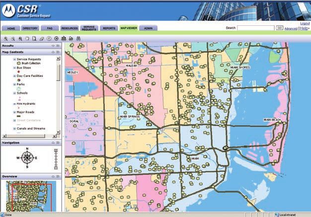
8 WHITE PAPER Location Centric CRMUsing CSR mapping enables
Miami-Dade to see the munici-
pal boundaries, the location of
citizen requests, and the tools
to analyze the storm damage
during hurricane events.
Miami-Dade discovered that CSR, coupled with their 3-1-1 Answer Center, helped improve disaster planning
and recovery, making CSR a valuable crises Performance Management tool. Becky Jo Glover, 3-1-1 Answer
Center Manager at Miami-Dade, says, “The technology used at 3-1-1 enables the County leadership to make
real-time decisions based upon real-time events. Miami-Dade can deploy resources to address urgent
community needs.”
In hurricane prone Miami-Dade, CSR supports the planning process, event triage, and post-event analysis.
During active events, CSR’s mapping provides significant insight into the hurricane’s impact. For example,
the areas that are not calling into the center may be in need of urgent response. Managers can use CSR’s
mapping and performance metrics for post event analysis to help determine where to deploy resources
during future events. As a result, managers can implement process changes targeted at improving low
performing areas.
Streamlines Service Delivery
CSR not only supports citizen request management, but also stands as a powerful workforce automation
tool that improves the end-to-end service delivery process. The spatial ability of GIS coupled with CSR’s
business process automation allows departments to peel away the levels of jurisdiction to find out who
owns what, route the service request directly to the owner, and measure results against defined metrics.
CSR’s ability to plan workday assignments by mapping service requests provides agencies enormous
benefits during every-day departmental operations. With CSR mapping, dispatchers can manage the daily
workload through intelligent crew assignment and route planning—saving travel time and mileage. In
addition, departments can also map service routes to determine where to apply resources.
Through reallocation of resources, the City of Calgary achieved improved efficiencies in several departmental
operations including:
• Moving building/fire inspectors to areas where more inspections were requested
• Assigning road crews to areas with more pothole complaints
• Adjusting garbage routes based on the number of missed pick-up complaints
9 WHITE PAPER Location Centric CRMBy tracking work geographically and by status, CSR enables government Performance Management. Boosting service delivery efficiency is the ultimate objective of Performance Management. Service intake and issue capturing are only one component of the government CRM process. Because many processes share similarities, departments can duplicate and share routing, efficiency, and workflow techniques—saving time and resources. Continuous process improvements supplies government the tools it needs to achieve critical goals as detailed within Performance Management strategies. Improving Departmental Efficiency in Chicago The City of Chicago was the first to implement a comprehensive 3-1-1 system that provides information to citizens, tracks City services from intake to resolution, and fields non-emergency calls. “Linking 3-1-1 to the City’s CSR system took Chicago to another level,” says Ted O’Keefe, director of the 3-1-1 Center, who states that the City dramatically improved its efficiency and response time. For example, prior to implementing CSR, graffiti removal took at least a week. Now, it now takes an average of 3.7 days. Chicago uses CSR’s real-time performance reports to show trends and response times for specific types of service requests and the employees who perform them. This gives supervisors a powerful tool to assign work crews, allocate equipment, and monitor performance. Additionally, CSR provides vital management data on the timeliness of service delivery, allowing the establishment of performance benchmarks and specific outcomes. After reviewing the performance reports, department leaders can take corrective action to adjust resource distribution, level of effort or focus in the department, or revise departmental goals. The result is a more efficient, transparent, and responsive government. Generates Direct Cost Benefits CSR’s spatial analysis capabilities supplies business intelligence to government leaders and managers. Broadly speaking, this allows them to make informed decisions about resource utilization, understand trends in their jurisdiction, and support business process improvements to deliver greater ROI. Consider the following success stories: • The City of Chicago’s Bureau of Electricity tracks requests for streetlight issues using coordinate grids. Call centers match each street light outage to a defined location, which then become duplicates to the initial service request. In 2004, the City estimates that it saved almost $13 million by eliminating the need to dispatch multiple crews to repair the same light. • The City of Baltimore’s Bureau of Solid Waste reduced overtime for mixed refuse pickup by more than 10,700 hours over a 12-month period. Baltimore accomplished this by geographically identifying duplicate requests and determining where and when to best deploy resources. This approach allowed the bureau to confirm the validity of complaints before making a site visit, saving the bureau nearly $250,000 in reduced overtime. • Baltimore’s CIO office reports “The combination of comprehensive CRM tools on the front end such as 3-1-1 and CSR, coupled with a powerful management accountability system such as CitiStat on the back end, produced more than $300 million in savings and revenue enhancements over the past five years. Specifically, we achieved the benefits from reduced overtime, reduced operating costs, increased on-the-job productivity, increased revenue streams, and the termination of costly, low-priority projects.” Location-based CSR drives how government does business throughout the entire service delivery model—including a successful customer service strategy, efficient service delivery process, and an effective Performance Management process. 10 WHITE PAPER Location Centric CRM
Motorola CSR is a location-centric solution built to improve government response
to its citizens, fully leveraging the power of GIS.

Motorola CSR…Using Location to Deliver a Higher
Standard of Government Service to Your Citizens
Using CSR, government agencies can transform the way they deliver services to their citizens, achieve
greater operational efficiencies, and proactively improve the communities they serve. Citizens can count on
having an efficient, knowledgeable point of contact for their non-emergency issues.

CSR captures your citizen’s service request details, routes the request to the proper agency, tracks
workflow progresses, and measures performance, all with a location aware approach. Using location paired
with a robust workflow engine, CSR helps improve agency efficiency and bridge municipal silos. In fact,
CSR transforms the way government does business. Case after case proves the cost savings and increased
citizen satisfaction resulting from a CSR implementation.

For over a decade now, Motorola has delivered our comprehensive CSR solution for managing non-
emergency requests from first call to issue resolution. CSR systems are scalable to fit your community,
whether large or small. You can deploy a single department or build an enterprise solution. A CSR system
can help you achieve:

•   Improved constituent satisfaction and public image
•   Greater accessibility to government information and services
•   A proven disaster response system, to support all non-emergency coordination
•   Efficient collaboration across districts, departments, jurisdictions, and government layers
•   Transparent accountability for government workers, management, and elected officials
•   Reduced operating costs and productivity improvements

CSR optimizes government interactions and service delivery to its citizens – by Location. For all levels of
government, CSR’s location-centric data module can help support the “way” and “how” citizens expect
their government to respond.

11 WHITE PAPER Location Centric CRM
Turn to the CRM Leader for the Public Sector
Motorola is the leading provider of government CRM solutions. For more than 70 years, we have worked
with state and local governments to understand and meet their needs for mission-critical communications
and information systems. Our unique perspective and extensive experience, coupled with deep technical
expertise, allow us to design solutions that take into account the special requirements of government
organizations like yours. Motorola can assist you with every step, from initial needs definition through
design, installation, financing, ongoing maintenance, and upgrades. We offer program management
services and professional consulting assistance, as well as a range of service options up to and including
full outsourcing. We will be happy to work with you to develop a total solution that optimizes your return
on investment. For more information about our company please visit www.motorola.com/CSR.

About Motorola
Motorola is known around the world for innovation and leadership in wireless and broadband communica-
tions. Inspired by our vision of Seamless Mobility, the people of Motorola are committed to helping you get
and stay connected simply and seamlessly to the people, information, and entertainment that you want and
need. We do this by designing and delivering “must have” products, “must do” experiences, and powerful
networks -- along with a full complement of support services and applications. A Fortune 100 company with
global presence and impact, Motorola had sales of US $42.9 billion in 2006.

Motorola, Inc.
1301 E. Algonquin Road
Schaumburg, Illinois, 60196, U.S.A.
www.motorola.com/CSR

MOTOROLA and the Stylized M Logo are registered in the U.S. Patent and Trademark Office. All other product or service names are the property of their respective owners.
© Motorola, Inc. 2007

RO-20-2012
You can also read