Facing the urban transition in Hanoi: recent urban planning issues and initiatives - Danielle Labbé - Espace INRS
←
→
Page content transcription
If your browser does not render page correctly, please read the page content below
Facing the urban transition in
Hanoi: recent urban planning
issues and initiatives

Danielle Labbé
Facing the urban transition in
                                                 Hanoi: recent urban planning
                                                 issues and initiatives

                                                 Danielle Labbé

Institut national de la recherche scientifique
Centre - Urbanisation Culture Société

January 2010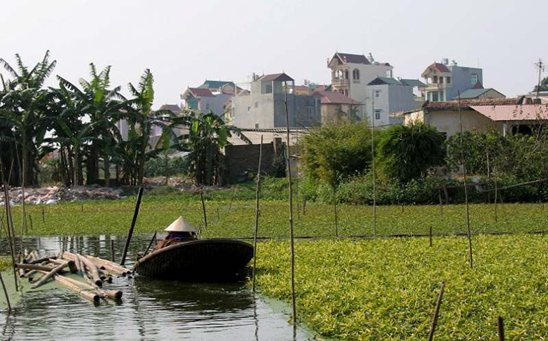
Responsabilité scientifique : Jean-Pierre Collin
jean-pierre.collin@ucs.inrs.ca
Julie-Anne Boudreau
julie-anne.boudreau@ucs.inrs.ca
Institut national de la recherche scientifique
Urbanisation, Culture et Société

Diffusion :
Institut national de la recherche scientifique
Centre - Urbanisation Culture Société
385, rue Sherbrooke Est
Montréal (Québec) H2X 1E3

Téléphone : (514) 499-4000
Télécopieur : (514) 499-4065

www.ucs.inrs.ca

ISBN 978-2-89575-201-1
Dépôt légal : - Bibliothèque et Archives nationales du Québec, 2010
              - Bibliothèque et Archives Canada
© Tous droits réservés
TABLE DES MATIÈRES

URBAN TRANSITION IN VIETNAM: ISSUES AND PROSPECTS ............................ 1

FACING THE URBAN TRANSITION IN HANOI: RECENT URBAN
PLANNING ISSUES AND INITIATIVES ..................................................................... 5

1. INTRODUCTION .................................................................................................. 5

2. HANOI PORTRAIT: HISTORY, TERRITORY, POPULATION, AND
   ECONOMY ........................................................................................................... 7

3. URBAN AND ARCHITECTURAL HERITAGE PROTECTION ............................ 13

4. PUBLIC SPACE UPGRADE AND PROVISION .................................................. 17

5. URBAN TRANSPORTATION: FROM PRIVATE MOTORBIKES TO RAPID
   MASS TRANSIT ................................................................................................. 21

6. HOUSING PROVISION ...................................................................................... 27

7. PERI-URBAN INTEGRATION ............................................................................ 33

8. CONCLUSION AND RESEARCH AVENUES..................................................... 39
    8.1    Integrating Rural and Urban Regional Planning ..................................................... 39

    8.2    Updating Urban Management Mechanisms ........................................................... 40

    8.3    Improving Urban Land Development Planning and Coordination .......................... 40

    8.4    Understanding and Dealing with Urban Poverty..................................................... 41

    8.5    Getting Ready to Face Climate Change ................................................................. 41

REFERENCES ......................................................................................................... 43
iv

                                                 Liste des figures

Figure 2.1 Map of the Hanoi city-province ............................................................................................. 8

Figure 2.2 Map of pre-colonial Hanoi ..................................................................................................... 9

Figure 2.3 Hanoi’s opera house was built during the first decade of the 20th century. ....................... 10

Figure 3.1 Traditional shophouse in the Old Quarter ........................................................................... 13

Figure 3.2 Colonial villa ........................................................................................................................ 14

Figure 4.1 The new Hang Trong Park offers very few recreational options to users. .......................... 17

Figure 4.2 Multiple uses of sidewalk space compete with each other ................................................. 18

Figure 4.3 Sidewalk spaces are extensively used in the new urban areas of Hanoi. .......................... 19

Figure 5.1 Hanoi’s streets look like a continuous stream of motorcycles. ........................................... 21

Figure 5.2 Traffic jams are increasingly common in Hanoi. ................................................................. 22

Figure 5.3 Passenger waiting for the bus in Hanoi .............................................................................. 23

Figure 5.4 Artist’s rendering of a light-rail transit station in Hanoi........................................................ 24

Figure 5.5 New buses interchange at the foot of the Long Bien Bridge .............................................. 25

Figure 6.1 Houses produced by individual households in the 1990s ................................................... 27

Figure 6.2 “The Manor,” a new urban area on the outskirts of Hanoi .................................................. 28

Figure 6.3 Bird’s eye artist rendering of Splendora .............................................................................. 30

Figure 7.1 A new high-rise building overlooks a traditional building in a peri-urban village
          under urbanization. .............................................................................................................. 33

Figure 7.2 Typical peri-urban landscape juxtaposing aquaculture and new houses ........................... 34

Figure 7.3 High-rise buildings in an NUA under construction on the western edge of Hanoi .............. 35

Figure 7.4 A new golf course in the region of Hanoi. ........................................................................... 37

.
Urban Transition in Vietnam: Issues and Prospects
                Jean-Pierre Collin and Julie-Anne Boudreau
               Centre - Urbanisation Culture Société of INRS

Building on two cases studies on the periphery of Hanoi (An Khanh, a commune
recently transformed by planned urbanization policies, and Tan Trieu, which has been
urbanized more spontaneously and for a longer period of time), this research conducted
in partnership with the Sustainable Developement Institute of the North (SDIN) at the
Vietnamese Academy of Social Sciences (VASS) seeks to better understand how various
forms of urbanization (planned, spontaneous) have impacted the life of people and their
relationship with state authorities in a centralized and communist political system that is
undergoing deep transformation due to economic liberalization.

Indeed, processes of urbanization in Vietnam take various forms that can broadly be
divided into two categories: communities that have experienced planned urbanization
versus communities that have experienced spontaneous urbanization (creating what
would commonly be called slums). While spontaneous urbanization remains important
on the periphery of large cities such as Ho Chi Minh or Hanoi, since the years 2000, the
central state has embarked on large-scale urbanization planning with the goal of
fostering economic development. This has meant central decisions to transform
agricultural land into “urban” land (industrial development, new housing for migrant
workers) and revitalization in slum areas (displacing slum dwellers into public housing
complex). Whether urbanization was planned or not, these state policies have immense
consequences for local communities (formerly farmers, or formerly slum dwellers, or
new migrant workers arriving from other areas of Vietnam). In all cases, people have to
cope with numerous challenges: 1) finding new means of living (employment, access to
food, new household time management habits and patterns of mobility), 2) competition
for scarce resources between rural and urban households (changing land tenure), 3)
adapting to rapidly changing (and thus confusing) land use patterns, infrastructure
development and regulatory frameworks.

Periurban spaces, defined as spaces of transition, are fruitful sites for understanding
Vietnam’s socioeconomic and political transformations. Serving as a bridge between the
traditional rural milieu that has historically dominated the economic and sociocultural
life of the country and an urban milieu that is (re)constructing its identity, this periurban
interface enables us to qualitatively explore urban integration. Periurban spaces are
undergoing intense changes at the level of land tenure regulation, economic structures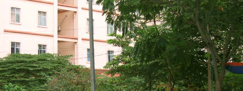
2

(industrialization, foreign investment, infrastructure development, private business),
demographic structures (densification, fertility rates, migration), and spatial
organization (architecture, urban sprawl, housing, etc.).

Our research questions are the following:

    1. What are the coping strategies developed by residents to address the economic,
       social and cultural transformations brought by urbanization?

           a. employment strategies

           b. access to food and consumption patterns

           c. management of family life (gender role, mobility patterns)

           d. conflict mediation and relations with newcomers to the communities

    2. How has the evolution of the central state’s attitude towards urbanization (from
       a negative to a positive perception) influenced people’s perception of these deep
       transformations? How do perceptions compare to the reality of differentiated
       degrees of poverty and wealth?

    3. Were there new civil society organizations formed as a result of these
       transformations? To what extent are these new organizations participating in the
       regulating and planning processes? How and to what extent is local urban
       development taken in charge by these new organizations?

    4. How are populations and authorities coping with environmental problems and
       solutions, in relation to poverty issues?
This research is a pilot for a larger collaborative project on how local populations in
Vietnam cope with the multiplicity of transformations and uncertainties associated with
periurbanization and extreme climate events. In the context of institutional and political
redefinition in Vietnam, this project aims to better understand how periurban local
people and authorities cope with multiple rapid transformations affecting their everyday
lives. More specifically, it looks at two interrelated major forces of change: urbanization
(with a focus on land conversion) and extreme climate events (which may be aggravated
by global climate change). These two forces bring much uncertainty, yet we
hypothesize that local people develop many micro-adaptations strategies, which we
hope to uncover. In order to do so, this project offers a social scientific approach to a
debate currently dominated by climate sciences and urban planning. To this end, this
investigation is centered on concepts of risk perception and social vulnerability. This
will allow an exploration of how the urban transition and climate change combine to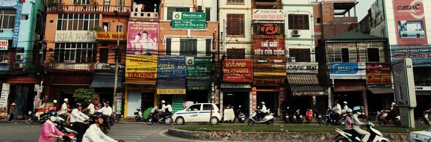
3

affect local living conditions (livelihood strategies, consumption and mobility patterns)
of periurban household as well as the reconfiguration of actors involved in policy-
making and decision-making processes. Five cities of different size, located in four of
Vietnam’s lowland socioeconomic regions, have been pre-selected as case study sites.
In each city specific communes will be identified where both quantitative and
qualitative data will be collected. The study expects to uncover localized micro-
adaptation strategies devised by the populations and authorities caught up in the
maelstrom of periurban and climatic transformations. Ultimately, these adaptation
strategies will inform policy recommendations aimed at strengthening local resilience
and mitigation capacities. These recommendations will be developed and disseminated
through a partnership with the Association of Cities of Vietnam (ACVN), and
interactions with local authorities and the government of Vietnam (through the
intermediary of the Vietnam Academy of Social Sciences).

We wish to thank the Social Sciences and Humanities Research Council of Canada, the
ministère des Relations internationales (Québec), and the scientific direction of the
INRS for their financial support, as well as our Vietnamese colleagues at SDIN-VASS.
Facing the urban transition in Hanoi:
         recent urban planning issues and initiatives
                              Danielle Labbé
               Centre - Urbanisation Culture Société of INRS

1. INTRODUCTION

Vietnam is currently experiencing one of the most intensive urban transitions in the
world. Over the next 25 years, its cities and towns are expected to grow at an average
rate of 6% per year, increasing the national share of Vietnam’s urban population from
one-third to one-half (MoC 2009). This shift from a rural to an urban society is closely
associated with socio-economic reforms instituted in the 1980s that progressively
liberalized the economy and relaxed the grip of the state on population movements and
activities. These reforms fostered a swift transition to an urban society through
combined processes of rural-urban migration, occupational shifts away from agriculture,
the physical expansion of existing urban areas, and the creation of new cities and towns
in densely-settled rural communes.

As the nation’s capital city and second largest agglomeration after Ho Chi Minh City,
Hanoi is one of the key sites of this urban transition. Vietnamese political leaders
acknowledge the fact that the growth of Hanoi and other cities is crucial to the shift
from agriculture to manufacturing and higher order services as well as to improve the
material well-being of the national population. At the same time, the rapid growth of
populations and activities in and around cities puts intense pressure on local authorities
to keep pace with rising demands for infrastructure, social services, housing,
environmental controls, and public amenities. Therefore, while there is consensus on the
potential benefits of urbanization, concerns are also raised by local and foreign
academics, professionals, and decision-makers about the importance of anticipating and
addressing problems ensuing from the urbanization process.

The mechanisms by which the people and authorities of Hanoi plan to ensure the
sustainable growth and development of the city’s territory, society, and space are still
very much in the making. While many problems remain to be addressed, recent years
have seen the emergence of urban development initiatives that aim to mitigate the
negative impacts of urbanization. These are the focus of this report. This survey is
organized as follows: The first section provides a contextual background on Hanoi,
sketching a portrait of its history, territory, population, and economy. The subsequent
sections describe problems and initiatives taken in five urban planning areas: heritage
preservation, public space, transportation, housing production, and peri-urban
6 integration. Existing conditions in each of the areas along with the mechanisms proposed by planning authorities and other stakeholders to cope with emerging issues are presented. The topics of each section are illustrated with case studies. The report concludes by identifying areas in need of further research.
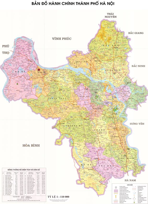
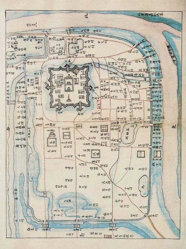
2. HANOI PORTRAIT: HISTORY, TERRITORY, POPULATION, AND
   ECONOMY

Hanoi is situated in the head of Vietnam’s Red River delta. The city-province is
bordered by the provinces of Thai Nguyen to the north, Bac Ninh and Hung Yen to the
east, Vinh Phuc to the south, and Phu Tho and Hoa Binh to the west (see Fig. 2.1). Most
of Hanoi’s area lies within the low floodplain of the Red River, historically a site of
intensive wet rice agriculture. The remaining area is part of Soc Son District (to the
north), which is somewhat mountainous and hilly.

While Hanoi has been occupied by human populations for more than 2,000 years, the
city’s origins officially date back to 1010, when the emperor Ly Thai To built a citadel
and established the capital of his empire on the right bank of the Red River.
Progressively, a small trade area developed next to the imperial city that is now referred
to as the “Old Quarter” (see Fig. 2.2). Throughout the following eight centuries, the city
developed slowly due to state control of trade and a succession of tumultuous wars
between competing dynasties. By the time the French settled in the city, in 1874, Hanoi
was a relatively small agglomeration of less than 100,000 people. Socio-spatially, it
consisted of a combination of three distinct spaces: a citadel, a merchant quarter, and an
agglomeration of rural villages surrounded by a dike (Logan 2000; Papin 2001).

Hanoi was the capital of French Indochina from 1902 to 1953, during which time it
remained a modest city both in size and population, never exceeding 400,000
inhabitants (Wright 1991). Yet French planners greatly transformed the appearance and
functioning of the city. Up to the end of the 19th century, colonial authorities expanded
the city area toward the south and west. There, they developed a new area with broad
avenues which, organized in a grid system and flanked by spacious villas and gardens,
is now referred to as the “Colonial Quarter.” The French also developed major
infrastructures and facilities, including the Long Bien Bridge, a railway and train
station, a post office, and an opera house (see Fig. 2.3).
8

    Figure 2.1 Map of the Hanoi city-province
                 Source: VIAP
9
Figure 2.2 Map of pre-colonial Hanoi
Source: Ngô Đưc Thọ et al. 2002
.10
Figure 2.3 Hanoi’s opera house was built during the first decade of the 20th century.
Source: NXBTT 2006: p.39
In 1946, the Democratic Republic of Vietnam (DRV) took power and declared Hanoi its
capital. The newly independent nation went through the First Indochina War (1945-
1954), followed by the Vietnam War (1962-1975). The government policy of de-
urbanization or dispersal of the population and industries away from Hanoi during the
wars limited both the physical and demographic growth of the city (Nguyên Duc Nhuan
1978). Nevertheless, by 1965, Hanoi’s total population had reached one million. The
city was not to exceed this figure for several decades, for two main reasons: continued
control on rural to urban migration, and economic hardship of the 1980s (Thrift and
Forbes 1986). In the early 1990s, after the launch of a set of policies known as the “Doi
Moi” (renovation) policies, urban population increased substantially. From then on, the
city’s population grew at an annual rate of approximately 3% to reach 3.2 million by
2007. Most of this new population consisted of rural migrants from surrounding
provinces, with natural growth playing only a minor role in the population increase
(Ledent 2002; Gubry et al. 2002).11 Hanoi’s administrative boundaries were redrawn several times throughout the 20th century. Among the major changes was the large territorial expansion of the province in 1978 to encompass over 3,000 km2 (Rossi and Pham Van Cu 2002: 314-17). The boundaries of the province were then redrawn in 1991 around a smaller territory of 900 km2. Thereafter, most of the administrative territorial changes consisted of attributing an urban status to parts of rural districts peripheral to the city (Quertamp 2003: 86-93). In 2008, the administrative boundaries of Hanoi were once again extended to include the neighbouring province of Ha Tay as well as a handful of districts and communes that formerly belonged to the provinces of Vinh Phuc and Hoa Binh. Upon completion of this project, the territory of the capital reached 3,300 km² (3.6 times the size of the previous area). In doing so, Hanoi absorbed wide areas of agricultural land that now constitute two-thirds of its territory. This expansion also implied a doubling of the official population of the capital city, namely, from 3.2 to 6.4 million inhabitants. A large part of this new population is classified as “rural” (3.7 million people, against 2.5 million classified as “urban”) (HSO 2009). In terms of population, Hanoi still comes just after HCMC (6.8 million) but the city is now far ahead of Hải Phòng (1.8 million) and Đà Nẵng (822,000). Although encompassing less densely settled areas, Hanoi’s population density has now reached an average of 1,926 persons per km2 (HSO 2009). The official objectives of the expansion were manifold. The enlargement served to reaffirm the status of the capital city of Vietnam both at the national and regional scale. The so-called “New Hanoi” is expected to become a centre of politics, education, science, economics, and international exchanges. The new territory is expected to contribute to the economic and functional development of the city by encouraging investment, including official development aid (ODA) and foreign direct investment (FDI), and by allowing the expansion and modernization of the region’s infrastructure network. The new territory is also expected to help accommodate the city’s demographic growth and distribute the population outside of the overcrowded urban core (VET 2008). The exact intentions for the future of the New Hanoi will be revealed with the release of the Master Plan for 2030 and Vision for 2050. These two documents have been in preparation since 2009 by a consortium of three planning and architectural firms from South Korea (JICA and Posco) and the United States (Perkins Eastman) working in collaboration with the Vietnam Institute of Architecture and Planning (VIAP).
12

Hanoi’s economy is growing steadily. The city’s GDP expanded three-fold between
2000 and 20081 (HSO 2009: 65). While Hanoi is only home to 7% of Vietnam’s
population, it contributes 12.5% of the national GDP.2 Although the city-province
encompasses a significant area of agricultural hinterland, Hanoi’s contribution to the
GDP from the primary sector is rather low. Hanoi’s gross output of industry is also
relatively low, representing only 13% of the country’s total output (compared to 25%
for HCMC) in 2008. Hanoi is indeed a less industrialized region than HCMC. As can be
expected from a capital city, the proportion of the population working in the
government sector is relatively high, representing 9% of the province’s workforce
(compared to 6% in HCMC and 2% in Hai Phong) (HSO 2009). A growing part of
Hanoi’s economic growth also comes from FDI. In 2008, Hanoi received close to
US$18.8 billion in FDI, accounting for 7% of the total investment in Vietnam (HSO
2009: 222).

The current intentions of the national and municipal authorities are geared to develop a
knowledge-based urban economy. This is manifest in the decision to build a large high-
technology satellite city 30 kilometres west of the city. Upon completion, the so-called
“Lang Hoa-Lac Hi-tech City” will accommodate major universities and high-quality
industrial production and human resources (Nguyen Thai Huyen 2009). The creation of
this “high-tech city” is part of a larger regional development approach that fosters the
creation of a multi-polar urban region consisting of autonomous satellite cities dispersed
around the existing agglomeration.

1
    Based on current prices. However, this period also saw an important rise in inflation.
2
    While substantial, this contribution is only half of that of Ho Chi Minh City.
3. URBAN AND ARCHITECTURAL HERITAGE PROTECTION
The protection of architectural heritage in central Hanoi has a long history. The roots of
this movement can be traced back to the beginning of the 20th century when the French
started to identify and catalogue remarkable monuments on the Indochinese peninsula
(Nishimura 1997). While concerns for the built heritage faded during wartimes and
throughout the subsidy era3, it revived again in the early 1990s. Following the re-
opening of Vietnam’s borders to foreign visitors, Hanoi revealed to the rest of the world
one of the best preserved cities of Southeast Asia.
The city’s architectural and urban heritage combines exceptional monuments and
compounds such as pagodas, temples, the citadel, and government buildings scattered
through the urban fabric. Hanoi also displays exceptional urban ensembles. The core of
the city consists of a traditional merchant quarter dating back to feudal times. This area
is characterized by an organic network of narrow streets lined with traditional
shophouses (see Fig. 3.1) (Pham Dinh Viêt 1997).
Figure 3.1 Traditional shophouse in the Old Quarter
Source: D. Labbé, 2004
3
Vietnamese use the expression “thoi bao cap”—literally translated as “subsidy era”—to refer to the period stretching from 1954 to
1986 during which the state subsidized a large part of socio-economic activities.14
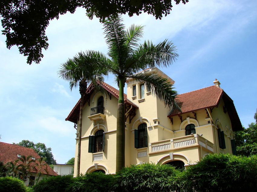
South of the Old Quarter is the Colonial Quarter, an area planned under the French that
functioned as the administrative and commercial centre of Indochina. As mentioned,
this area is characterized by a regular street grid of broad avenues, lined with trees and
flanked by luxurious villas (see Fig. 3.2). Hanoi’s urban fabric further includes a myriad
of erstwhile rural villages now engulfed into the urban fabric. The city is also
characterized by a unique natural environment with numerous rivers and lakes, tree-
lined streets, and parks.
Figure 3.2 Colonial villa
Source: D. Labbé, 2005
This built and natural heritage experienced considerable transformations over time,
either due to war destruction, poor maintenance during less affluent periods,
transformations by users due to changes in needs and tastes, and demolition to make
way for larger and more profitable buildings (UNCHS 2002: 4-42). According to many
experts, Hanoi’s built heritage is at risk of disappearing if nothing is done to curb
degradation, inappropriate renovations, and rapid demolitions (Logan 1994; Maclaren
1996; Parenteau and Champagne 1994; Nguyên Quang and Kammeir 1997; Terunobu et
al. 1997). Throughout the 1990s and 2000s, this prognosis catalyzed an onslaught of
preservation-oriented development projects. During this period, more than twenty
development projects, funded by ten different organizations, addressed the issue of
preserving the built heritage of the Old Quarter and the Colonial Quarter.15
These preservation projects set out with a relatively narrow focus on architectural
preservation but progressively embraced wider concerns about tradition, including the
preservation of immaterial heritages such as traditional economic activities and
lifestyles. Nevertheless, on the whole these heritage preservation projects tended to
focus on a small number of symbolic monuments and on the preservation of the Old
Quarter and the Colonial Quarter to the detriment of other components of Hanoi’s built
and natural landscape. Hence, many of the lakes that once characterized the city have
been filled. The rivers and canals that were once a part of what gave the city a unique
character are also being progressively buried underground (a decision often justified by
high pollution levels) (Shibayama et al. 2008). At the same time, the former villages
that are being integrated into the city space are also witnessing the disappearance of
their ancient gates, central ponds, ancient houses, and other cultural and architectural
landmarks.
Box 3.1: Thang Long Imperial Citadel
In June 2006, the government of Vietnam submitted an application to the UNESCO
for the classification of the Thang Long Imperial Citadel complex as a World
Heritage site. The citadel is a highly significant place in Vietnam’s national history.
The complex covers approximately 50 hectares. It corresponds to the areas of the
Forbidden City and Imperial Citadel which were first built during pre-colonial
times. While most of the original buildings were destroyed during wars, many relics
remain underground that have been unearthed by archaeologists, including many
architectural vestiges and artefacts from the period during which Vietnam was
under Chinese domination and from more recent dynasties. All over the site,
cultural layers appear and are testimonies of continual cultural and physical changes
during a period of over 13 centuries. The Vietnamese authorities are hoping to get
the Thang Long Imperial Citadel listed as one of the UNESCO World Heritage site
in time for the millennial of Hanoi, in 2010.
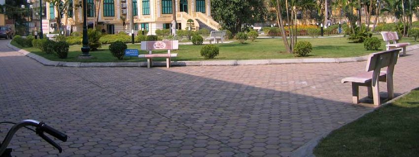
Sources: http://whc.unesco.org/4. PUBLIC SPACE UPGRADE AND PROVISION
Hanoi is recognized as one of the most overcrowded cities in the world. In 2008, human
densities in the urban districts reached an average of 272 persons per hectare and up to
404 persons per hectare in the historic core (compared to 370 persons per hectare in
Hong Kong, 86 in Paris, and 62 in London) (ABD 2006). Such human densities put
enormous pressure on the city to provide common spaces for people to engage in social
interactions, exercise, get away from the traffic and pollution, and enjoy environments
other than the exceptionally cramped quarters of their homes (UNCHS 2002).
However, Hanoi can hardly meet the demand of its citizens for public space.
Recreational areas, in particular, are insufficient to serve the urban population. Urban
parks account for only 0.3% of the city’s territory and represent less than 1m2 per
person. These figures are far below the urban park area offered by other cities in the
region. Bangkok, to take only one example, has nearly twice as much urban park area
than Hanoi (1.8 m2/per capita, see Thaiutsa et al. 2008).
Figure 4.1 The new Hang Trong Park offers very few recreational options to users.
Source: D. Labbé, 200918
Existing parks are unevenly distributed across the city. They concentrate in the urban
core with approximately 1.5 m2 of park space per capita in the four central districts,
while the urban peripheral districts offer only 0.05 m2 of park space per capita. The
parks in Hanoi lack accessibility, in particular for young people and the elderly. About
half of Hanoi’s residents do not have a park within walking distance or with easy access
from their house (HAIDEP 2005). Moreover, existing public spaces, even large ones
such as Reunification Park, often offer few recreational options to users. Instead, urban
public spaces in Hanoi are generally designed with an emphasis on ornamental
flowerbeds and geometrically patterned alleyways. Such areas can hardly meet the
population’s growing demand for spaces that foster socializing and participation in
recreational activities (see Fig. 4.1).
The lack of formally designated and easily accessible urban public parks is informally
compensated by the extensive use of the sidewalk and street spaces in the inner city.
The sidewalks of Hanoi are the site of an eclectic array of activities spanning domestic,
social, recreational, and commercial uses (see Drummond 2000 for a discussion). Such
practices often result in conflicts between public uses and the private appropriation of
public space (see Fig. 4.2).
Figure 4.2 Multiple uses of sidewalk space compete with each other
Source: D. Labbé, 2009
The rampant personal and commercial use of public space is manifested by the plethora
of street vendors, sidewalks being taken over by shop owners for private use (cooking
and eating), and children’s use of streets as their public playground, even to the extent
of competing with busy traffic in narrow lanes. This is compounded by the rapid growth
of the use of motorcycles, invariably parked on sidewalks and forcing pedestrians to
walk in the streets among vehicles. In recent years, municipal authorities have19
attempted to regulate sidewalk use more strictly, prohibiting mobile vending and
controlling some of the private appropriation of public space by shop owners (Kurfürst
2009; Koh 2008). Yet, even the most regulated sidewalks of Hanoi cannot replace safe
and accessible public parks where residents can get away from traffic and air pollution,
enjoy larger playgrounds, and make use of quality community meeting spaces.
Figure 4.3 Sidewalk spaces are extensively used in the new urban areas of Hanoi.
Source: D. Labbé, 2009
Vietnamese authorities recognize the importance of public spaces in the development of
a sustainable and people-friendly city. This is reflected in national planning standards
for parks and green spaces issued by the Ministry of Construction which theoretically
has to ensure the provision of green areas in Hanoi. According to existing regulations,
developers must design new residential areas with approximately 3 to 4 m2 per capita of
parks and gardens in order to get development approvals and buildings permits. In
reality, however, the criteria on minimum park areas are not fully applied and the
responsible authorities do not impose fines on developers who fail to meet prescribed
standards. As a result, many older public parks in the inner city are in need of
improvement, with sidewalks in the new residential areas at the periphery often serving
as the only accessible public space available to residents (see Fig. 4.3).20
Box 4.1: Thuong Dinh Ward’s Playground Upgrade
Thuong Dinh ward is one of Hanoi’s poorest urban wards as it is home to a large
proportion of migrants and adults with unstable jobs and low income. Like in other
poor inner-city neighbourhoods, the lack of green and open spaces has become a
chronic problem in this community. In 2006, a team consisting of Vietnamese
researchers, foreign academics, and a local NGO attempted to remedy this situation
through an innovative community-driven public space improvement project.
The project targeted a small playground which was highly degraded because of low
maintenance and improper use. The project aimed at turning this space into a safe
and accessible community park. It involved local people at all phases, from design
to post-construction maintenance. Early on in the process, ideas were gathered from
local people who asked for raising the site above floodwaters, access to outdoor
seating, for a new playground, and for a community-information posting board. A
student-architect voluntarily provided design ideas which served as the basis for
community discussions. A ward staff from the local People’s Committee helped
produce technical drawings, cost estimation, and negotiated the construction price
with the contractor (also a local resident). Many people, including migrants living
nearby the playground, made cash contribution to the project.
While ward authorities first worried about the community’s capacities, they finally
agreed to delegate most of the tasks associated with the upgrade initiative to local
people. A Management Committee consisting of both members of the community
and authorities was established for supervising the construction. Upgrading work
was carried out within two weeks and provided employment for about ten local
unemployed people. At the end of 2008, the new playground was handed over from
the ward to the community which has since then been responsible for its
maintenance and appropriate use.
Since the upgrade, local residents started to plant trees and flowers in and around
the new playground and cleaning work is now carried out every Sunday morning
under the leadership of a young volunteer.
The ward leaders believe that this experience can be widely replicated across the
city and local people believe that it led to a tightening of the local community’s
relations. Although at a very small scale, this authority-community collaborative
project demonstrates that urban poor in Vietnam have ability to contribute ideas,
financing, labour, and to manage infrastructure projects.
Source: Nguyen Thi Hien 20095. URBAN TRANSPORTATION: FROM PRIVATE MOTORBIKES TO RAPID
MASS TRANSIT
Urbanization in Hanoi is accompanied by rapid motorization, much of which due to
recent wealth accumulation during the liberalization of the private economic sector. The
resulting urban traffic is nearly unparalleled by that of other cities in the world. The
Vietnamese capital is indeed characterized by the lowest use of public transportation
and the highest proportion of private transportation of all Asian capitals.4
The rapid motorization of Hanoi is characterized by a predominance of motorcycles.
Since its first introduction to Vietnam during the subsidy era, this small four-stroke,
two-wheel vehicle has become a symbol of high personal mobility, an asset value, and
one of the most convenient means of transportation in a city the urban fabric of which is
dominated by narrow alleys (JBIC 1999). Motorbike ownership in Hanoi is reaching
high rates compared to income levels, and this despite high import-taxes (70% to 100%)
and registration fees. Four households out of five in Hanoi own a motorbike and two out
of five own at least two (AFD 2008).
Figure 5.1 Hanoi’s streets look like a continuous stream of motorcycles.
Source: J.-F. Légaré-Tremblay, 2009
The rise of motorbike ownership has turned a city where, in 1990, over 80% of trips
were made by bicycles to one where, in 2005, nearly 65% of the 6.3 million daily
journeys were made on motorbikes (ABD 2006). From 1995 to 2005, motorbike trips
4
By 1999, the modal share of buses in Hanoi accounted for less than 6% while it accounted for 70% in Manila in 1996, above 50%
in Jakarta in 1985, and above 45% in Bangkok in 1995 (JBIC 1999: II).22
have multiplied by six. The constant increase in motorcycle ownership is now also
becoming paralleled by a growing number of cars. In 2005, only 2% of households in
Hanoi owned cars, representing less than 4% of the city’s modal share. But between
2004 and 2007, new vehicle registrations in Hanoi increased at a two-digit rate,
reaching 20% over the last two years (Hieu Nguyen Ngoc 2009). In the meantime, the
number of non-motorized vehicles—especially bicycles—on the streets of Hanoi is
plummeting (see Fig. 5.1 and Fig. 5.2).
The already overloaded and weak traffic infrastructure of Hanoi is bearing increasing
pressure. The road network represents less than 7% of the land area (compared to about
15% in most European cities and 11% in China’s large cities). An expansion of the road
system is restricted by the severely high cost of resettlement, which constitutes over
80% of a given project budget. Over the last decade, travel speed and travel time in
downtown Hanoi have worsened not only due to traffic congestion but also to longer
travel distances. The latter is fostered by a master plan prescribing the decentralization
of spatial structures, which further exacerbates the need for transportation linkages
between the city centre and the suburbs (ABD 2006).
Figure 5.2 Traffic jams are increasingly common in Hanoi.
Source: J.-F. Légaré-Tremblay, 2009
Changes in the mix of traffic, slow progress in roads development, undisciplined
driving styles, and lax enforcement of traffic laws increasingly worsen the traffic in the
city. The ever-growing traffic congestion has many negative effects: exclusion of23
vulnerable populations (children, the elderly or disabled, poor populations without
vehicles, etc.), rise in transport costs, urban productivity declines, as well as increasing
greenhouse gas emissions, air pollution, noise, and accidents (ISTED 2006).
Public transportation once played a significant role in the capital’s urban transportation
system, namely, in the early 1980s, when the modal share of buses accounted for 25 to
30%. However, the number of routes and the frequency of the service then decreased in
the 1990s, when subsidies for state-owned enterprises began to get curtailed (JBIC
1999: III). Public transportation nearly collapsed entirely in the late 1980s when
ridership dropped from about 40 million per year to almost nothing (HAIDEP 2007: 8-
7). For more than ten years, Hanoi thus seemed to be establishing itself as a non-public
transit city. To counter this direction, the national government recently launched a new
policy that places public transportation as a priority over other urban concerns. Among
its ambitious targets for Hanoi is the stipulation that 25 to 30% of trips in 2010 and 50
to 60% in 2020 must be carried by public transportation5 (HAIDEP 2007: 8-7).
Figure 5.3 Passenger waiting for the bus in Hanoi
Source: C. Musil, 2009
In 2002, the city of Hanoi, for its part, launched a policy aimed at reviving the nearly
extinct bus system. New bus routes were established, the vehicle fleet was expanded,
and bus shelters and passenger information schemes were introduced (see Fig. 5.3). The
resurgence of the public bus system since 2002 succeeded beyond expectations. In
5
Public transit is not the sole focus of the Vietnamese authorities in terms of transportation infrastructure development with
ambitious programs for highway construction also underway.24
2003, ridership was more than three times as high as during the peak year of the 1980s
(HAIDEP 2007). Yet, despite a spectacular 20-fold increase in bus ridership from 1.2
million monthly trips in 2001 to over 24 million monthly trips in 2006, public transport
still only accounts for only 10% of total trips (ABD 2006).
In light of the fact that the above-mentioned traffic congestion limits the attractiveness
and impacts of a public bus system, new rapid mass transit (RMT) projects operating
outside the regular road network are currently on the drawing boards. Following recent
recommendations from the Japanese International Cooperation Agency (JICA), two bus
rapid transit (BRT) lines are awaiting funding approvals by the World Bank. In parallel,
two rail-based projects are also in the making: a 12.5 kilometre east-west light rail
transit line partly financed by France and a new metro line linking downtown Hanoi to
its international airport (15 kilometres to the north), financed by the Japan Bank for
International Cooperation (JBIC) (see Fig. 5.4) (ISTED 2006). These two projects were
originally expected to be completed for the Hanoi’s 2010 millennium celebrations but
have suffered significant delays.
Figure 5.4 Artist’s rendering of a light-rail transit station in Hanoi
Source: www.archipel-asia.com
International experience shows that large BRT and rail-based transportation systems
take a long time to put in place. In the meantime, much can be done to improve the
current transportation system (see, for instance, Box 5.1). According to the Asian
Development Bank (2006), there is a need to complement planned improvements in
public transport with a comprehensive mobility management strategy that includes car
and motorcycle parking fees, improved enforcement, i.e., collection, of vehicle
registration fees for motorcycles, and taxes on gasoline (currently among the world’s
lowest). Moreover, more attention is needed to increase the efficiency and safety of the
current stream of traffic. Traffic management is still nascent and Hanoi residents have
been slow to accept many basic traffic management techniques. Continued engagement
is needed to build capacity and to prioritize the need for safety and order over unfettered25
mobility. There is also a need to enhance the capacities of the institutions responsible
for land-use development, and to integrate their missions with other transport and
infrastructure plans.
Box 5.1: Long Bien Bus Interchange
In 2009, the City of Hanoi inaugurated a new bus interchange on the edge of the
city densest and busiest neighbourhood. This project was developed through a
decentralized cooperation project between the city of Hanoi and the Région Île-de-
France with funding assistance from the Ecotrans project. This new bus interchange
demonstrates how small-scale but finely designed interventions can substantially
improve transportation quality in Hanoi.
The new bus interchange is efficiently handling a large volume of bus flow and has
considerably improved inter-modality in the area. The new facility can handle
nearly 300 buses per hour at rush hour and over 3,500 passengers a day. It includes
waiting platforms for users, stopping zones and dedicated bus right-of-way lanes,
nearby taxi and park-and-drive facilities for motorbikes and a quick connection to
the Long Bien train station, providing inter-regional rail links. Altogether, these
improvements have significantly facilitated the redistribution of passenger flows
into the central and historic quarters of the capital and to suburban areas and eased
conflicts between users.
In addition to its functional success, the bus interchange has become an
architectural landmark in the area, innovatively integrating component of the urban
landscape in which it was inserted. It is also providing a public space of quality.
Achievements of perhaps deeper meaning are the genuine recovery of this space by
the citizens of Hanoi, appreciative of their vernacular heritage, and the
reinforcement of the links between the people one of the historic symbols of their
city: Long Bien Bridge (see fig. 5.5).
Source: www.imv-hanoi.com
Figure 5.5 New buses interchange at the foot of the Long Bien Bridge
Source: C. Musil, 20096. HOUSING PROVISION
Urban housing is a perennial problem in Hanoi. The issue can be traced back to the
subsidy era when the urban housing sector was allocated a meagre part of state
resources. This was compounded by a subsequent 30 years of wartime economy and the
destruction of buildings by bombing (1945-1975) (Papin 2001; Thrift and Forbes 1986).
By the late 1980s, the acute lack of housing space manifested in population densities
reaching 30,000 persons/km2 in the inner city (Gubry et al. 2008). Inevitably, this
under-investment in housing by a centralized state that kept promising a rapidly
growing urban population the “right to shelter” became a source of popular discontent
(Dao Thi Thu Huong 1999).
The adoption of the Doi Moi policies greatly influenced housing production in Hanoi.
Major changes included the withdrawal of public housing subsidies and the
encouragement of an emerging private housing development sector along with
traditional self-help housing production (Trịnh Duy Luân 1995; Thuc Huy Trinh 2005).
In the 1990s, the progressive removal of state control over the housing and construction
market conflated with newly-formed private capital to foster a construction boom
mainly driven by informal self-help housing practices (see Fig. 6.1) (Everestz 2000;
Parenteau 1997).
Figure 6.1 Houses produced by individual households in the 1990s
Source: O. Jacques, 200928
By 2000, over 70% of the residential floor area built in Hanoi was produced by private
households using their own funds (Geertman 2007). Most of this housing production
took place without construction permits (Koh 2006). Moreover, by the early 2000s, as
much as 90% of the houses in Hanoi did not have proper housing ownership and land
use-rights certificates6 (Luong Thi Hong Hanh 2001).
This self-help housing production contributed to decrease unsustainable housing
densities in the inner city. Between 2000 and 2008, average housing areas per capita
went up from 4.7 m2 to 7m2 (VNS 2009; JBIC 1999). Yet, self-help housing has
systematically been appraised by local experts as a sub-optimal answer to the housing
shortage in Hanoi. One of the main problems is that a large proportion of the dwellings
so produced do not qualify for basic neighbourhood infrastructures, including
environmental utilities and services such as clean water and electricity. The spatial
landscape ensuing from this informal urbanization is also considered as disorderly and
unsuitable for the capital city of a modern, developed, and civilized Vietnamese nation
(PHC 2000; Nguyen Xuan Mai 2001; Lưu Trọng Hải 1995).
Figure 6.2 “The Manor,” a new urban area on the outskirts of Hanoi
Source: D. Labbé, 2005
The proportion of housing space produced by individual households started to decrease
in the early 2000s. By 2008, private households produced just over half of Hanoi’s
urban housing (HSO 2009: 215). This situation was closely tied to the changing
6
In recent years, local authorities have tightened their control over construction activities and legal requirements and informal
housing construction has substantially decreased in most urban districts.29 dynamic of Hanoi’s housing production during the same period. By the late 1990s, central and municipal authorities developed an urban development model referred to as “new urban areas” (khu do thi moi, hereafter NUA). NUAs are large-scale integrated developments displaying standardized urban forms and consumer-oriented architecture (Douglass and Huang 2007; Waibel 2006). They are characterized by the use of a so- called “synchronous planning approach” where the infrastructure system and public facilities are developed concurrently to mixed-use residential constructions (see Fig. 6.2). Over the last decade, over a hundred NUAs have been built around Hanoi, some covering only a few hectares and others covering large expanses of territory and constituting self-contained satellite towns. These projects are, for the most part, invested by domestic enterprises, including a large number of former state-owned construction companies. Yet, in recent years, an increasing number of projects have involved foreign capital originating from the East and Southeast Asian regions (especially Korea, Taiwan, and Singapore) (see Box 6.1). Underpinning the original NUA initiative is the following idea: by supplying good quality housing affordable for all strata of the urban population and located in planned “modern” environments, informal urbanization practices would be progressively marginalized and eventually superseded by a state-guided vision of the urban (Pandolfi 2001). Unfortunately, since its implementation, this initiative has not managed to meet the needs of the ever-growing number of households for dwellings in the capital city. Demand continues to outstrip the supply of housing in NUAs, which in turn fosters speculation. Most NUA villas and apartments are sold off-plan and then re-sold many times prior to completion. Shortage in housing supply has pushed prices up in a succession of so-called land and housing fever periods (Hoang Thi Lich 1999). From 1991 to 1992, prices increased tenfold and from 2001 to 2004, shot up 500% (Hoang Thanh 2007). Hanoi’s land and housing prices are still among the highest in the region. In 2007, a house in the old city was selling for about US$4500-5000 per square metre, an apartment in a mid-range high-rise building at the periphery for about US$1000-1500 per square metre, and an apartment in a lower-range resettlement building for about US$800 per square metre (Tien Manh 2007).
30

     Box. 6.1 Splendora
     Splendora is a massive 264 hectares urban development on the western side of
     Hanoi. The US$2.57 billion zone is invested and built by a joint-venture consisting
     of the state-run Vietnam Construction Import-Export Corporation (Vinaconex) and
     South Korean steel-maker subsidiary POSCO Engineering & Construction (POSCO
     E&C). The first phase of the project, expected to be completed by 2012, will offer
     1,000 villas and apartments, office blocks, retail centers and public infrastructures.
     The project is marketed as an “eco-friendly” and “international environment” with
     “fresh air, dreaming spaces created by artificial lake, flowers gardens, green
     areas” where residents will have a “one-stop life” with “high-class international
     schools, and other functional spaces such as entertainment, culture, office,
     shopping center” available on site. The project is also strongly oriented towards
     security and global aspiration: “at Splendora, you can meet the model of New York
     economic center, fashion and culture center of Paris, tourist and entertainment
     center as Dubai, Sydney…symbol of global life.” The project is expected to be
     completed in 2020 (see fig. 6.3).
     Source: VNA 2009; www.ankhanhjvc.com

                    Figure 6.3 Bird’s eye artist rendering of Splendora
                               Source: www.ankhanhjvc.com

In the current housing market, households with enough capital or good connections to
the state are seizing opportunities to improve their lives, constructing many buildings
themselves and taking advantage of regulatory loopholes in order to speculate in the
land market. But others, looking for affordable housing, are finding that the cost of even
modest housing has become much steeper. The poor, in particular, encounter great
difficulties to access housing (see Box 6.2).
31
Box 6.2: Out of Reach
“Twenty-nine year-old Nguyen Thu Nga can only dream of owning an apartment in
Ha Noi. Nga and her husband are currently renting a small apartment in a five-
storey building in Thanh Xuan District. They earn a total of VND 5 million ($294)
per month, barely enough to get by with their small child in the city: "I’ve heard a
lot about the Government’s project to build cheap houses for low-income earners;
however, it’s still out of my budget," said Nga. Nga and her family have no monthly
savings to purchase a 50 square meters apartment in the capital, which would run
about VND 300 million ($17,600).
Source: VNS 2009
In 2009, Hanoi municipal authorities addressed this situation by announcing plans to
build 15,500 apartments totalling 1.5 million square metres to shelter students, workers
in industrial zones, and low-income Hanoi residents by 2015 (Quynh Nga 2009).
However, the federal government is not planning to subsidize housing directly, and
financial mechanisms to entice private developers to supply affordable housing are yet
to be defined. This is no small challenge. In a market where land values are on the rise
and with a private sector oriented toward more affluent households, one can hardly
expect the market to supply affordable housing. As noted in a recent interview by the
chairman of the Vietnam Construction Association, Pham Si Liem: “Investors need to
turn a profit. One square metre of commercial space can be sold from VND10-20
million (US$600-1,200), while it’s between VND 6-7 million ($350-410) for social
housing. Who would want to build these homes?” In the current market system, seeking
the highest possible returns on land development, the poor are still left to fend for
themselves.7. PERI-URBAN INTEGRATION
For four decades Hanoi remained confined within limited space. Under the influence of
a planned economy, lack of foreign investment, and moderate population growth, the
city was restricted to its four central administrative districts (1950-1990). The city’s
built fabric only started to overflow into suburban districts in the early 1990s. And, at
the turn of the century, urban expansion really began to accelerate with the relaxation of
state control over rural-to-urban land-use conversions. Since then, thousands of hectares
of agricultural land and hundreds of erstwhile rural communities have been engulfed
into the city’s physical and functional space (see Fig. 7.1). The scope and speed of these
changes pose an enormous challenge for local populations who face intensive socio-
spatial transformations as well as for planning authorities who are struggling to cope
with new demands for urban infrastructures, services, land uses, and environmental
controls.
Figure 7.1 A new high-rise building overlooks a traditional building in a peri-urban village
under urbanization.
Source: D. Labbé, 2009
Between the 1990s and the early 2000s, the urban expansion of the city into its rural
hinterland took place mostly informally. The process was largely driven by in-situ
urbanization of pre-existing settlements at the rural-urban interface of the city. Peri-
urban populations and territories were predisposed to such change. For hundreds of
years, the livelihood of people living outside of the city was based on rice cultivation34
and market gardening with crafts and semi-industrial activities such as basket weaving,
metallurgy, textiles, and food processing. This combination of activities required a large
workforce and fostered very high population densities: 1,200 inhabitants/km2 on
average, up to as much as 15,000 inhabitants per km2 in residential areas (Fanchette
2009: 4).
Figure 7.2 Typical peri-urban landscape juxtaposing aquaculture and new houses
Source: D. Labbé, 2005
The potential dynamism of peri-urban populations was relatively contained throughout
the subsidy era; however, in the early 1990s, the opening of the economy, the demise of
collective agriculture, and the redistribution of agricultural land provided the impetus
for rapid local transformations toward more urban land-uses and employment structures.
This created opportunities as well as needs for additional income in rural areas.
Individual households and whole villages started to intensify agriculture, to expand and
develop local handicraft and industrial occupations, and to diversify their livelihood
strategies by sending household members to work in factories or downtown (see Fig.
7.2) (DiGregorio 2009: 2).
Between 1994 and 1999, populations in the rural communes belonging to the city-
province of Hanoi grew by 65% (from 400,000 to over 625,000 people). Redundant
rural workers and manpower idle during the low season began to commute to urban and
suburban areas to work as traders or as industrial or casual workers on a permanent or
semi-permanent basis (Tana 1996). New wealth from the intensification of agricultural
and from craft activities and urban remittances impacted the physical space of villages
where families began replacing traditional rural homes with multi-story urban houses.
Altogether, rising population densities, intensified agriculture, small craft industry, theYou can also read