Flood Risk Research and expertise to understand, anticipate and protect - FLOODrisk 2020
←
→
Page content transcription
If your browser does not render page correctly, please read the page content below
Copyright: Philippe Cantet

Flood Risk
Research and expertise to understand,
anticipate and protect

prénom NoM

                                                                 Flood of the River Rhone in December 2003 in Fourques (Gard, South France). The dykes protect the town. Copyright: Paul Royet

 F
          lood risk represents the                               INRAE — the French National Research Institute for Agriculture, Food and
                                                                 Environment — has been an advisory body for the study and management of
          greatest natural hazard in                             water-related risks for over 35 years, providing scientific expertise and support for
          France. One person in four                             French and European policy and strategy on flood-risk management. INRAE is also
     is at risk1, leaving 17 million                             a national and world leader on the safety of hydraulic structures (levees and dams),
                                                                 and a major contributor to the works of both ICOLD (International Commission on
     inhabitants vulnerable.                                     Large Dams) and CFBR (the French Committee associated with ICOLD). The Institute
     The extreme flash flood events                              owes this prominence as much to its targeted research activities as to its expert
                                                                 advice and support for public initiatives. The work of its hydrologists, hydraulics
     of October 2020 and October                                 engineers and specialists in soil mechanics and civil engineering in Lyon, Grenoble,
     2015 in South-East France,                                  Aix‑en‑Provence and Antony focuses on understanding floods, risk control as well as
     which led to more than 20                                   prediction, and risk reduction and protection measures.

     deaths, and the exceptional
     plain flood on Seine catchment                              Understanding flood events
     of May-June 2016, when fewer                                in order to improve prediction
     lives were lost but considerable
     damage was caused to                                        > In order to study and model flood                              sharing and management: https://bdoh.
     property and infrastructure,                                events on different catchment scales, access                     irstea.fr/.
                                                                 to reliable, long-term data is required.
     are a reminder of just how                                  Since 2013, scientists and practitioners                         > Using data provided by INRAE and
     high the stakes are in terms of                             have been able to access INRAE (formerly                         Cerema (Centre for Studies and Expertise on
                                                                 Irstea)’s hydrological and biogeochemical                        Risks, the Environment, Mobility and Urban
     addressing this risk.                                       data from the long-term observatories it                         Planning), the BDHI (National Database
     How should flood risk be                                    manages or is actively involved in, such as                      on Historical Floods) keeps a record of
     managed?                                                    OTHU Yzeron, ORA-CLE, the Rhone Sediment                         exceptional floods that have occurred in
                                                                 Observatory and OHM-CV, Arc-Isere site                           France in previous centuries. It is updated
     Can flooding be predicted?                                  of the ZABR (Zone Atelier du Bassin du                           with data from new flood events, providing a
     And how can we protect                                      Rhône/Rhone Basin Long Term Ecological                           reference tool for all flood-risk managers. It
                                                                 Research Observatory) or Draix-Bleone                            has been available on line since March 2015:
     ourselves?                                                  observatory of IR OZCAR. This data is stored                     http://bdhi.fr. Another tool developed by
                                                                 in the Hydrological Observatories Database                       Inrae is dedicated to sediment transport data
     1
      national flood risk assessment for 2011, French Ministry
     fot the Environment, Energy, and Sea ( July 2012).          (BDOH), a collaborative tool for open data                       https://en.bedloadweb.com/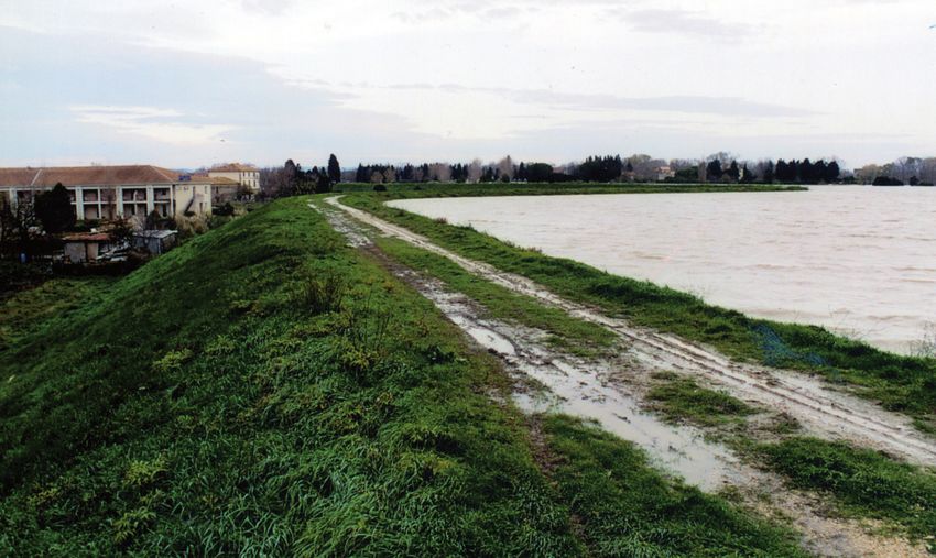
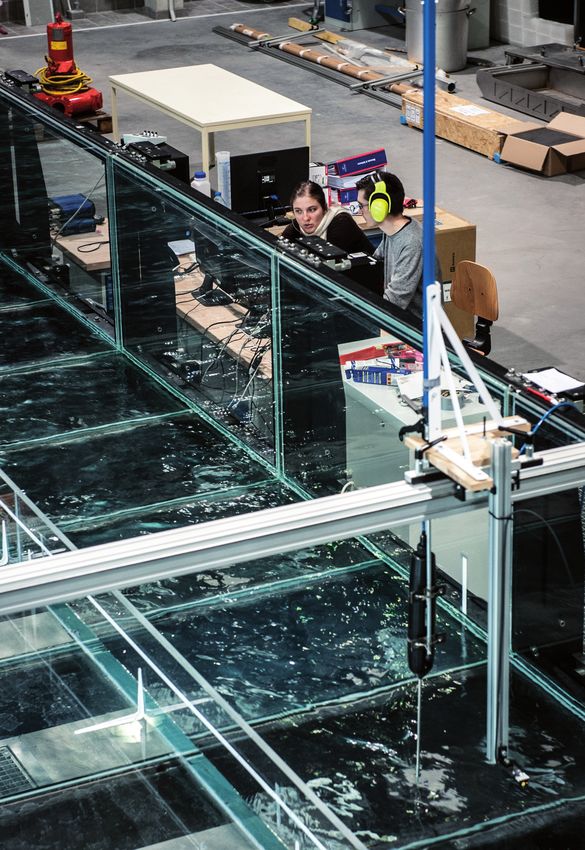
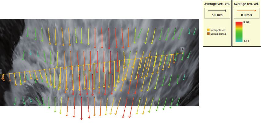
> The study of flash floods, which can                  > It is also possible to produce                                    in 2017, can be used to study floods in a
occur at any time in many places, including             laboratory-based simulations of extreme                             system of streets, with potential interaction
small unmonitored catchments, is a more                 flood events for different types of land                            with urban blocks and sewage systems.
complex matter, especially when there                   use, and INRAE’s platform at its Lyon                               Using these experimental facilities, hydraulic
is little available data. INRAE’s scientists            Villeurbanne centre — the only one of its                           modelling tools can be developed and
have recently carried out a scientific                  kind in Europe — is particularly useful in this                     validated to calculate the extent of flooding
assessment of the suitability and degree of             respect (https://riverhydraulics.inrae.fr/en/                       from rivers, urban systems, and failed
measurement uncertainty of new remote-                  tools/hydraulic-laboratory-hhlab/).                                 hydraulic structures.
sensing techni-ques to measure flow. Such               Its facilities include a glazed 18-metre‑long                       Hydraulic platforms dedicated to the
techniques are safer to use in flash floods and         and 3-metre‑wide flume with a set gradient                          experimental study of sediment transport
include portable speed radars and analysis              for studing the effects of different types                          and morphology of mountain streams and
of camera images and crowdsourced films                 of flood-plain surface roughness (such as                           rivers, including debris-flow torrents, are
posted on YouTube. Thanks to this unique set            meadows, woodland and housing) on a                                 also harnessed at INRAE Grenoble to predict
of data collected on the ground, it has been            river’s flow. An urban flood model, built                           flooding risks in mountain environments.
possible to validate tools for modelling flash
flooding on scales ranging from a few km2 to
2000 km2.

An example of using a crowdsourced flood video to
compute surface velocities and discharge using the
Fudaa-LSPIV software (images of the Gave de Cauterets
flood on 18 June 2013 found on YouTube)

> A further challenge lies in the
prediction of extreme hydrological events
(with a one in a thousand or even one
in ten thousand chance of occurring in a
given year) and their effects not only on the
behaviour of watercourses but also, beyond
these, on vulnerable local features (housing,
industries, transport infrastructure, nuclear
power stations, etc.). To compensate for
the lack of long-term data, the Institute’s
researchers have developed software for
simulating rainfall. The system, known
as a rain generator, is based on observed
rainfall statistics and generates long rainfall
time series. When linked to a hydrological
model, the rain-generator can produce flood
scenarios to identify future risks. Several
hydraulic and morphodynamic numerical
models are being developed for real-time
or ex-post simulation of flood propagation,
sediment transport and bed evolution.
This enables a better understanding of the
potential risks of flooding in long‑reach
networks including dam management or
locally.                                                Simulation of extreme floods in the hydraulic laboratory at INRAE’s Lyon centre. Copyright: Thierry Fournier
FLOOD risk

Practical tools                                  flood forecasting (SCHAPI). Based on the
                                                 flows measured in the rivers, this service
                                                                                                  > For steeply-sloping mountain areas,
                                                                                                  INRAE and Meteo France now offer an
for flood control                                produces a flood warning map, updated at
                                                 least twice a day (https://www.vigicrues.
                                                                                                  innovative risk management and warning
                                                                                                  service using a network of radars adapted
and prediction                                   gouv.fr/). It provides water levels in rivers,
                                                 compares them to reference levels (historic
                                                                                                  to cope with rugged terrain. The data they
                                                                                                  provide is processed using hydrological
> Research data underpins the                    floods), and forecasts their development         models so that local authorities can be
formulation of flood-control policies            over the next 24 hours. The GRP software         warned via the RHyTMME web-based
Ways must be found to anticipate the             (https://webgr.inrae.fr/en/software/grp/)        platform when there are risks of torrential
measures required to mitigate the                developed by INRAE in Antony is among            flooding, mud flows or debris flows and
worst effects of flooding. INRAE has             the tools most widely used by the regional       appropriate safety measures can be taken.
been developing innovative methods to            flood forecasting services to produce their      With three radars installed between 2011
assess flood risk in France. For example,        forecasts. This model calculates future          and 2015, the forecasting platform has been
the Institute has established a single           flows and their associated uncertainty           tested on the ground by local authorities,
standardised national database on flood          in real-time, based on observed rainfall         national agencies and other risk managers
flows (the SHYREG database). Used by the         and streamflow data and scenarios of             and has demonstrated its effectiveness. It
Ministry for Ecology and regionally-based        future rainfall. It has proven invaluable to     has been in operation in the Hautes-Alpes
state agencies, this database fills in gaps in   forecasters for anticipating flood events        since January 2016.
the available data for certain areas, thereby    and is currently used by most regional flood
helping to generate flood maps for Areas at      forecasting services in France.
High Risk of Flooding (TRIs) to comply with
the EU Floods Directive.

> Innovating methods for producing
flood discharge data
In partnership with river monitoring
agencies in France and abroad, INRAE has
developed new methods for safer, more
accurate observation of flood discharges,
and for quantifying the measurement
uncertainty.                                     Vigicrues map 14/04/2021, Provence-Alpes-Côte
Such methods have been implemented               d’Azur
in free software now commonly used
by hydrological services and academics           > Outside the monitored network:
alike. The Fudaa-LSPIV free‑software             the Vigicrues Flash service and the
(https://riverhydraulics.inrae.fr/en/tools/      AIGA method
measurement-software/fudaa-lspiv-2/) for         More than 100,000 km of rivers remain
video-based flow velocity and discharge          “unmonitored“, however. To plug this gap,
measurement has been co-developed                the state has also set up the Vigicrues
with EDF. Based on Bayesian inference of         Flash service, with the help of scientists       An X-band hydrometeorological radar installed at the summit
                                                                                                  of Mont-Colombis in the Hautes-Alpes. Copyright: Alix Guillot
hydraulic equations, BaRatin (for Bayesian       from INRAE Aix-en-Provence who have
Rating curve) and its BaRatinAGE graphical       developed the AIGA method (Adaptation of
                                                 Geographic Information for Flood Warning).       > Radar technology is now being
environment (https://riverhydraulics.                                                             exported to Sao Paulo in Brazil where
inrae.fr/en/tools/measurement-software/          Designed as a support tool for decision-
                                                 makers and managers in crisis situations,        intensive rainfall, especially in January
baratinmethod) are used to build stage-                                                           and February, causes torrential flooding
discharge rating curves and compute              the AIGA method does not provide the
                                                 value of the phenomenon (amount of               and landslides. In a joint project with the
discharge hydrographs with quantified                                                             Novimet company, INRAE’s scientists
uncertainty. The OURSIN method for the           rainfall or predicted flow rate, as with the
                                                 GRP model), but simply displays whether          have adapted their models to the urban
uncertainty analysis of hydroacoustic                                                             environment and subtropical climate of
profiler (ADCP) discharge measurements           it is unusual. For this purpose, the only
                                                 real-time data needed concerns the radar         the area. In particular, predictions are now
has also been implemented in the                                                                  updated every 10 minutes rather than every
internationally-used QRevInt software            rainfalls which are then transformed into
                                                 modelled flows. The results are expressed        hour (the default pattern for many French
(https://www.genesishydrotech.com/                                                                flood forecasting services) and the model
qrevint).                                        as return periods. For example, a flood
                                                 with a return period of 10 years means a         has been extended to include retention
> On the monitored network: the                  flood that has a 1 in 10 chance of occurring     basins designed to attenuate peak flows in
Vigicrues service and the GRP model              each year. Thus, the state services are          urban areas.
In France, 21,000 km of rivers are monitored     informed of the rarity of the current flood,
24 hours a day by the Vigicrues network,         even for rivers that do not have real-time
coordinated by the national centre for           measurements.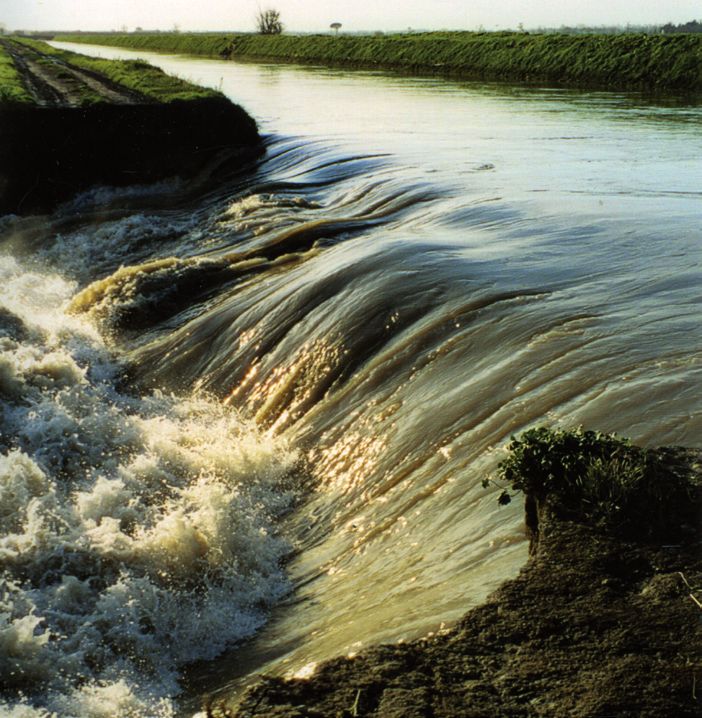
FLOOD risk
Ensuring the safety of levees and dams
> Levees, dykes, or floodbanks, are industrial partners such as EDF which owns a
designed to protect people and property considerable number of hydraulic structures
from flooding. However, the exceptional in France. The experimental apparatus has
floods of the past thirty years in France been handed over to two companies who are
– Camargue in 1993 and 1994, Aude in helping managers to assess their structures:
1999, Gard in 2002, Rhone in 2003 and GeophyConsult since 2012 and Sol Solution
Cyclone Xynthia in 2010 – have revealed a since 2014.
set of structures that are poorly recorded,
insufficiently maintained and neither fully > The repair and reinforcement of
managed nor fully regulated. levees is a further research priority. The
Natural risks in mountains and reality is that most are old and 65% are
hydraulic structures: INRAE’s expertise in a state of disrepair. Together with ISL
system certified ISO 9001 Ingenierie, INRAE is looking into the addition
of lime to strengthen river embankments.
In an ever-changing world, research contribu- As a stronger and cheaper option for the
tions are eagerly awaited and must be com- construction and repair of these structures,
mensurate with the challenges to be met . this method significantly bolsters resistance
In light of society’s expectations in to internal erosion and cuts down on the
terms of agriculture, food and the transport of materials. Full-scale tests are
environment, INRAE’s ability, as a public Experts inspect emergency repair work carried out now in progress to assess the resistance of
research establishment, to ensure a following Cyclone Xynthia. Copyright: Rémy Tourment a lime-treated soil embankment to surface
“research‑expertis“ continuum is essential. erosion.
It is within this framework that the INRAE’s > Monitoring the condition of every
Expertise and Public Policy Support single part of a levee is a challenge for
Department has been committed, since supervisors and managers alike, given that
the Institute’s creation in 2020, to the such structures can extend over many dozens
consolidation and external recognition of kilometres. INRAE’s specialists in levees,
of its expertise and public policy support in partnership with other research teams
missions. (such as Université Gustave Eiffel, Cerema,
Thus, at the beginning of February 2021, IGN and EDF) and specialist companies
INRAE was newly awarded the ISO 9001 (such as Geomatys, Fugro-Geoid, Tencate,
certification for the whole of its expertise Survey Copter and Sintegra), have developed An aerial view of the soil-lime experimental embank-
ment under construction. DigueElite project.
quality system related to the management high-return methods of data collection for Copyright: Dronimages
of gravity risks in the mountains (snow the assessment of structures. These rely on
avalanches, rock falls, debris flows, etc.) and the use of airborne Lidar technology (using > INRAE’s provision of scientific and
hydraulic structures (dams, dykes, etc.). helicopters and drones) and enables the technical support for the inspection of
This certification confirms the sound collection of affordable, high-precision data embankments on behalf of the Ministry
reliability of INRAE’s expertise in these areas for embankments ranging from 10 to 50 km of Ecology includes published reference
of high concern for public safety. in length. materials such as the “Réferentiel technique
In a recently published book, INRAE sur les digues maritimes et fluviales”
describes the first integrated method in (Technical Guide on River Embankments
France for conducting a risk analysis of and Seawalls) and the International Levee
levee systems: the culmination of years of Handbook. The Institute has also created a
development based on actual analyses on digital platform, WikiBarDig, which brings
real levee systems. together comprehensive information on
the design and construction of hydraulic
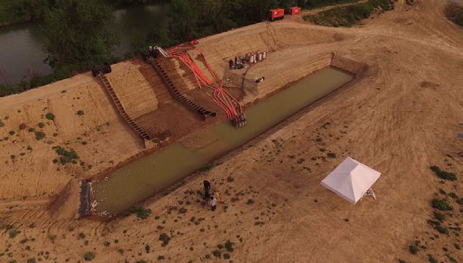
> Most levees are made of earth and structures (embankments and dams) and
their principal cause of failure is internal the processes that cause them to fail or
erosion. INRAE’s soil-mechanics experts have deteriorate with age.
developed an experimental device using The Institute is tasked with providing expert
the Hole Erosion Test (HET) to measure a advice to the Government and lends advice
levee’s resistance to erosion. This makes it during emergencies (Rhone 2003, Agly
possible to estimate the probable timespan 2013, Aude 2014). The extention of its
from the onset of the erosion process to original specialism in river embankments to
the failure of the structure, which can be a include seawalls was recognised and put to
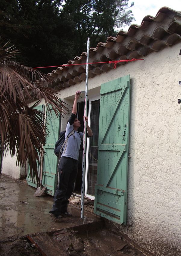
Breach on the Vigueirat dykes in December 2003 matter of hours, days, or longer. Thanks to good use in 2010 in the aftermath of Cyclone
Copyright: Rémy Tourment the HET, appraisal work can be carried out for Xynthia.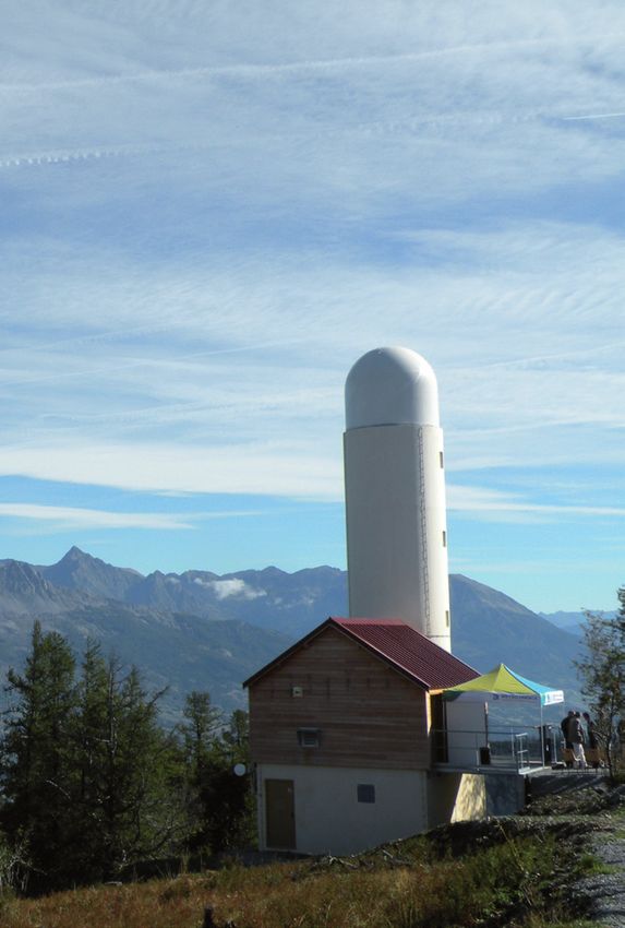
Creating the                                     INRAE’s flood research also includes
 management                                       new projects to address the economics
                                                  and sociology of flood management.
 strategies of                                    In Montpellier, the Institute is analysing
                                                  the viability of the various management
 tomorrow                                         and protective solutions, while in Bordeaux
                                                  it is investigating how governance needs
 > Improving our future readiness                 to adapt to current challenges in flood-risk
 requires us to foster memories of past           management.
 events. Various databases providing
 information on historical flood events from
 across the country (see above, BDHI) have
 been created by INRAE. Available to local
 authorities and groups and, in some cases,       INRAE: providing support for local
 incorporating information provided by            authorities
 members of the public, these are intended        Since 1 January 2018, new responsibilities
 to encourage the pooling of knowledge and        have been devolved to towns and their
 wisdom in order to create a risk culture that    authorities concerning the management of
 is shared by all.                                aquatic environments and flood control (GE-
                                                  MAPI). Not only is INRAE making available
 > On the basis of this historical data,          the tools and methods it has developed, but
 combined with the national evaluation of         its experts are also providing training, giving
 possible consequences of flooding (EPRI,         talks and setting up partnership projects to
 Preliminary Flood Risk Assessment), the          assist elected representatives and their staff
 122 areas at High Risk of Flooding (TRIs)        in their new role.
 in France and its overseas Departments           INRAE (Aix and Antony) also contributes
 have been identified. Flood-risk maps have       to the PICS project (coord. Univ. Gustave
 been generated for these in accordance           Eiffel, https://pics.ifsttar.fr/en/), aimed at
 with the EU Floods Directive. Local Flood        developing a new generation of integrated
 Risk Management Strategies (SLGRIs) must         modelling chains to forecast flash-flood
 be produced within the next six years. In        impacts. With reaction times of less than
 addition, each major catchment now has a         6 hours, these events can cause extensive
 Flood Risk Management Plan (PGRI). INRAE         damage with many casualties, especially in
 has been involved in each of these steps to      the Mediterranean region where extreme
 define and implement the French objectives       flood events are expected to increase in the
 and measures called for by the Directive.        context of climate change.

> Link between floods and climate                 of -23% in Eastern Europe to an increase
change                                            of +11% in Northwestern Europe. Warmer
When a major new flood event occurs, the          temperatures have led to earlier spring
link between the event and climate change         snowmelt floods throughout Northeastern
is debated, especially as damage caused by        Europe, while later winter floods around some
floods has increased significantly in recent      sectors of the Mediterranean coast could be
decades. The temptation is to interpret them      due to a change in atmospheric circulation
as warning signs of the impact of climate         patterns. The fact that no generalised trend
change, calling into question flood control       appears on the flood regime is related to the
measures. INRAE was involved in two               complexity of the physical processes that
pan-European stationarity analyses on flood       cause runoff. They depend both on climatic
characteristics recently published in Nature      evolutions acting on different regional
and Science. More than 3,700 gauging              scales and, in an area with a lot of human
stations with discharge data available over a     involvement, on human activity – often
50-year period (1960-2010) were examined.         flood control and land use change – which
The results show no consensus on observed         can either compoud climate changes
trends in floods, which may be shared on          or, conversely, compensate its effects.
a large scale, whether in terms of severity       Furthermore, the variability in discharge time
or seasonality of events. Europe displays         series is generally very large, especially where
trends, both increasing and decreasing, in the    extreme events are concerned, which makes it
intensity of floods: over the five decades, the   difficult to detect trends.
changes range from a decrease in peak floods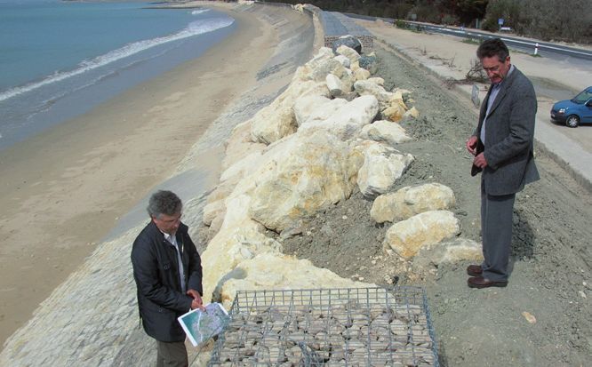
Copyright: Catherine Fouchier
French National Research Institute
for Agriculture, Food and Environment

                       INRAE
             147 rue de l’Université
              75338 Paris Cedex 07
             Tel.: +33(0)1 42 75 90 00

                   Join-us on:

              https://www.inrae.fr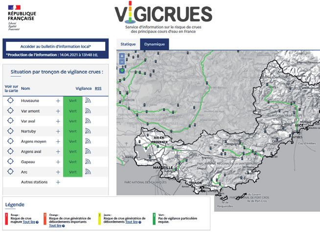
You can also read