2016-2021 CIP Project Descriptions - City and County of Denver Department of Public Works Wastewater Capital Projects Management - City and County ...
←
→
Page content transcription
If your browser does not render page correctly, please read the page content below
WCPM Project Descriptions for 2016-2021 CIP

           City and County of Denver Department of Public Works

                 Wastewater Capital Projects Management

                2016-2021 CIP Project Descriptions

Page | 1                                                        Revised : 2016-06-21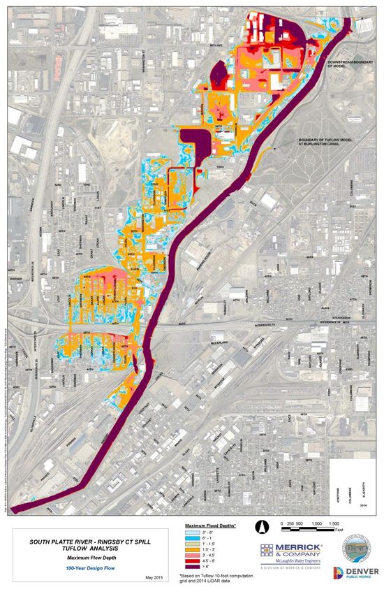
WCPM Project Descriptions for 2016-2021 CIP

Council
Districts   Table of Contents
Citywide    Citywide Concrete Repair Program - Annual ................................................................................................................. 3
Citywide    General Storm Drainage Capital Improvement Program - Annual................................................................................ 4
Citywide    Storm Project Development - Annual ........................................................................................................................... 5
Citywide    Storm Drainage Master Plan Implementation - Annual ................................................................................................ 6
Citywide    Storm Drainage Master Plan (SDMP) Update ............................................................................................................... 7
    9       33rd Street Outfall ........................................................................................................................................................ 8
    2       Glenbrook Detention Basin ........................................................................................................................................... 9
    4       East Yale Avenue Storm, Phase 1 ................................................................................................................................ 10
   8,9      E 16th Avenue Street System, Phase 1 ........................................................................................................................ 11
    8       E 16th Avenue System, Phase 2 .................................................................................................................................. 12
    9       27th Street Interceptor-Phase 1.................................................................................................................................. 13
   1,3      Lakewood Gulch-Sheridan Phase 2, Construction....................................................................................................... 14
  5,10      Jackson Street System ................................................................................................................................................. 15
    9       Marion Street System, Phase 1 ................................................................................................................................... 16
    6       Oneida & Tennessee to Cherry Creek, Phase 1 ........................................................................................................... 17
    8       Park Hill System, Phases VI & 38th Avenue – Dahlia to Holly ...................................................................................... 18
   1,3      UDFCD Study: Sloan’s Lake MDP and FHAD Update .................................................................................................. 18
    3       UDFCD Study: Lakewood Gulch MDP and FHAD ........................................................................................................ 20
   4,6      UDFCD Study: Goldsmith Gulch MDP and FHAD Update ........................................................................................... 20
   11       UDFCD Study: Irondale Gulch OSP update ................................................................................................................. 22
    8       UDFCD Study: Sand Creek (downstream of Colfax) MDP & FHAD ............................................................................. 23
Citywide    UDFCD Study Local Match ........................................................................................................................................... 24
    6       UDFCD CIP: Cherry Creek Stabilization-Holly to Iliff ................................................................................................... 25
    2       UDFCD CIP: Bowles Ditch Separation .......................................................................................................................... 26
    2       UDFCD CIP: Marston Lake North Drainageway MDP Implementation (Reaches 7, 8 and 9) ...................................... 27
    7       FEMA Grant: Sanderson Gulch, Reach 1 ..................................................................................................................... 28
    7       USACE Study/Design: CAP Program-River South......................................................................................................... 29
1,3,6,7,9   USACE Implementation – SPR & Gulches .................................................................................................................... 30
1,3,6,7,9   USACE Implementation – SPR & Gulches (cont.) ........................................................................................................ 33
Citywide    Regional Water Quality Project Development ............................................................................................................ 34
Citywide    Regional Water Quality Construction.......................................................................................................................... 35
Citywide    Public Restrooms Program .......................................................................................................................................... 36
Citywide    Capital Project Support - Annual ................................................................................................................................. 37
Citywide    General Sanitary Improvements ................................................................................................................................. 38
Citywide    Sanitary Project Development - Annual ...................................................................................................................... 39
Citywide    Sanitary Master Plan Updates ..................................................................................................................................... 40
   10       E Cherry Creek Sanitary Upsizing ................................................................................................................................ 41
    9       49th Avenue, Phase 2 Sanitary .................................................................................................................................... 42
    9       York Street Sanitary Improvements ............................................................................................................................ 43

    Page | 2                                                                                                                              Revised : 2016-06-21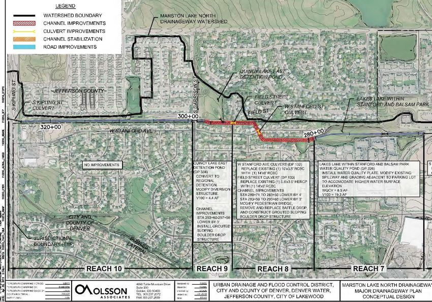
WCPM Project Descriptions for 2016-2021 CIP

Citywide Concrete Repair Program - Annual

This is an on-going cost-shared program with Public Works - Street Maintenance for improvements to
the City's curbs, gutters and cross-pans, handicap ramps, and miscellaneous concrete repairs to facilitate
drainage in the streets and to address critical safety hazards.

Benefits/Avoided Losses:
Areas selected for repair are typically in advance of street paving that is scheduled for the following
year. Improvements to deteriorated portions of curbs and gutters help to direct storm drainage to the
nearest storm drain intake. Cost-sharing with Street Maintenance funding improves the amount that
can be done. Additionally, this program focuses on specific areas with the highest needs thereby
ensuring better bids and more efficient allocation of funds and staffing resources.

Page | 3                                                                            Revised : 2016-06-21
WCPM Project Descriptions for 2016-2021 CIP

General Storm Drainage Capital Improvement Program - Annual

This is an annual on-going program to complete multiple projects to address flooding and other storm
water management issues City-wide. Examples of projects include extending existing storm sewers,
replacing corroded storm pipes, constructing storm drains and open channels, and constructing
interceptor lines where needed.

Benefits/Avoided Losses:
Storm drainage improvements constructed in this program help to reduce localized flooding problems,
as well as reduces impacts on maintenance staff, time, and equipment in responding repeatedly to the
same location.

Example:

Page | 4                                                                          Revised : 2016-06-21

WCPM Project Descriptions for 2016-2021 CIP

Storm Project Development - Annual
This provides “seed money” for project development work and tasks related to storm drainage projects
in the 6-year Capital Improvement Program that are budged in a future fiscal year, but for which scoping
analysis is needed now. This work includes engineering studies, utility locates & dig-ups, environmental,
professional services, etc.

Benefits/Avoided Losses:
This allows issues to be investigated prior to design in order to improve the formal design process of
future-funded storm drainage projects.

Page | 5                                                                             Revised : 2016-06-21
WCPM Project Descriptions for 2016-2021 CIP

Storm Drainage Master Plan Implementation - Annual
This provides annual funding for planning and feasibility studies to refine future storm drainage capital
improvement projects identified in the City’s Storm Drainage Master Plan.

Benefits/Avoided Losses:
This provides funding to respond to storm drainage investigations not anticipated during the annual
budget cycle so that projects can continue to be developed.

Page | 6                                                                             Revised : 2016-06-21
WCPM Project Descriptions for 2016-2021 CIP

Storm Drainage Master Plan (SDMP) Update
In accordance with Denver Revised Municipal Code, Division4, Section 56-110, Denver’s Storm Drainage
Master Plan is updated every five (5) years in order to identify and alleviate present and future drainage
problems in the City.

Benefits/Avoided Losses:
   • Provides a high-level assessment of the drainage needs throughout the city in order to identify
       where existing storm drain infrastructure does not meet current criteria and where new storm
       drains are needed.
   • Includes new information gleaned from other drainage studies conducted in the past five years.
   • Provides updated storm drainage project costs based on the most up-to-date cost data from
       recently-bid projects.
   • Provides a mechanism to coordinate projects with other Divisions within Public Works such as
       the Bridge Group, Street Maintenance Division, as well as Policy, Planning, and Sustainability.
   • Identifies top-priority projects for the 6-year Capital Improvement Plan budget.
   • Utilized by developers and engineers to provide an overview of drainage issues affecting specific
       sites and areas.
   • Informs Community Planning & Development (CPD) Neighborhood Plans and Station Area Plans.
   • Informs council members and residents about the potential for drainage problems in their
       community and to be proactive in addressing potential flood concerns.

Page | 7                                                                             Revised : 2016-06-21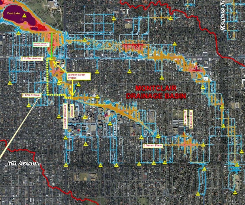
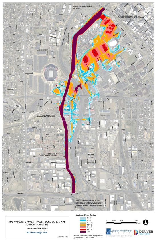
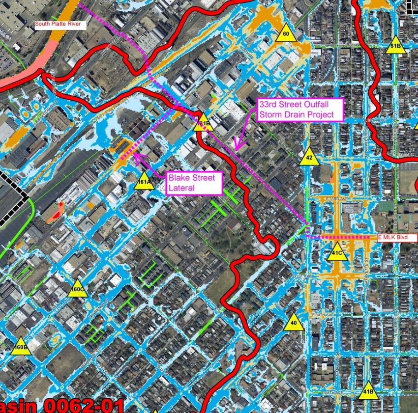
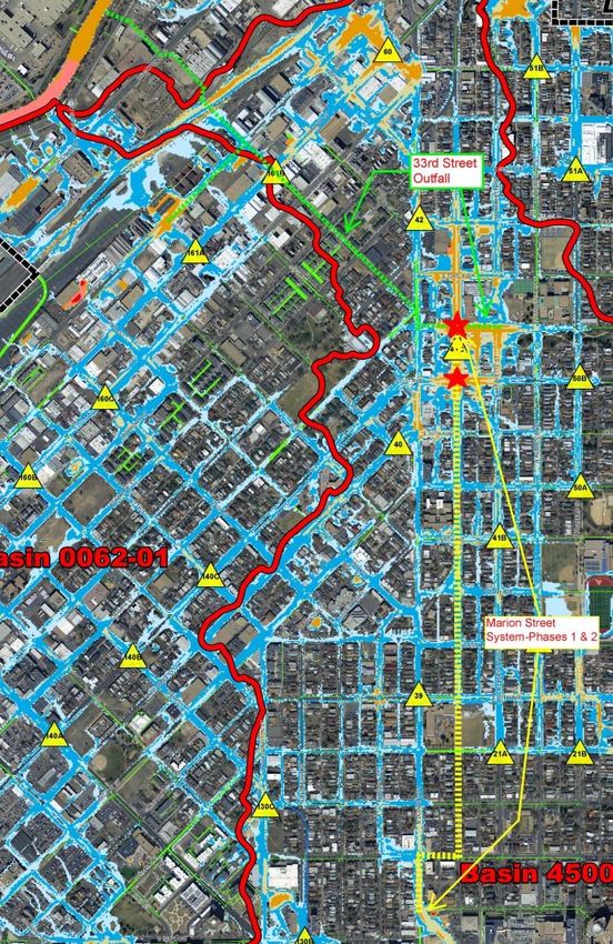
WCPM Project Descriptions for 2016-2021 CIP

33rd Street Outfall

This project is to improve the drainage conditions in Storm Drainage Basins 0062-01 & 4500-02 during a
5 year storm event. The Five Points, Whittier, and City Park West Neighborhoods are situated in these
drainage basins.

The storm drain construction starts at the South Platte River progressing uphill in 33rd Street, crossing
the Downing Street intersection and continuing upstream in Martin Luther King Boulevard from
Downing Street to Lafayette Street.

Benefits/ Avoided Losses:
This will address significant flooding locations at Martin Luther King Boulevard and Marion Street where
2-dimensional flood modeling indicates flood depth of up to three (3) feet deep in a 100-year storm
event shown on the subsequent map in orange. In addition, a lateral system will be constructed in Blake
Street from 31st Street to 33rd Street in order to reduce flood risk at 31st and Blake, where numerous
condominiums flooded on August 8, 2008 and July 11, 2011.

The system would collect storm runoff from the existing storm drain in Downing Street and provide the
ability to extend the improved storm drainage system upstream into the Whittier Neighborhood via the
future “Marion Street System” to address significant flooding at E 31st Avenue and Marion Street and
reduce flood risk in the Five Points and Whittier Neighborhoods between Martin Luther King Boulevard
and E 21st Street.

Page | 8                                                                              Revised : 2016-06-21
WCPM Project Descriptions for 2016-2021 CIP

Glenbrook Detention Basin

This project is to increase storm water detention and water quality and reduce flood risk to adjacent
residential properties located on the northern project boundary from flooding. One home was flooded
April 11, 2005 when snowmelt from a significant storm spilled out of the existing detention basin. The
project is situated in the Marston Neighborhood in southwest Denver. The project will preserve the
existing wetlands in the existing detention basin and provide improved stormwater detention in the
City-owned natural area adjacent to the Garrison/Union Park. Upon completion, this project will
provide a stormwater detention and water quality pond, underground storm sewer facilities, landscape,
and irrigation facilities. In addition, a new concrete trail system will be constructed to connect the
existing trail system to the neighborhood and the Garrison/Union Park.

Benefits/Avoided Losses:
Provide a 100-year level of flood protection to adjacent properties thereby improving public safety,
improve storm water quality treatment, preserve existing wetlands, and disconnect urban storm runoff
from entering the Bowles Lateral Irrigation Ditch, which is located adjacent to the existing detention
basin. The new storm drain in S. Garrison Street constructed with this project will intercept and collect
storm runoff from south of Bowles Lateral Irrigation Ditch, further reducing storm runoff that currently
can enter the irrigation ditch; thereby improving water quality and reducing liability.

Page | 9                                                                             Revised : 2016-06-21
WCPM Project Descriptions for 2016-2021 CIP

East Yale Avenue Storm, Phase 1
The goal of this project is to mitigate flooding that occurs frequently at the sump in S. Glencoe Street,
south of E Yale Avenue which has been identified as a Significant Flooding Location in the City’s Storm
Drainage Master Plan. Phase 1 (low point in Glencoe St. to Dahlia St.) will provide approximately a
10‐year storm drain system that will significantly improve the drainage conditions in the sump, or low
area, during the smaller and more frequent storm events. The phase 1 improvements will not provide a
100-year storm system due to physical limitations in the E. Yale Avenue corridor. This project is located
in the eastern part of the University Hills Neighborhood in southeast Denver.

Benefits/Avoided Losses:
Repetitive flooding has been reported at 2765 S Glencoe, 2752 S Glencoe, and adjacent properties.
Flooding was reported on June 3, 2005 at 2752 S Glencoe in the Denver Post. Subsequent storms on
May 14, 2007; May 28, 2007; July 4, 2007; July 3, 2009; July 14, 2011 and July 14, 2014 also produced
flooding, some damaging. On July 3, 2009, 3 cars were flooded in the street and floodwater reached 3
attached garages and the threshold of 2765 S Glencoe Street. The July 14, 2011 storm flooded one car
and left a debris line 12” up on the garage door at 2765 S Glencoe.
The project improves public safety and contains flooding in the residential area during a major storm by
providing an additional temporary outfall system. The existing overhead utility lines on south side of E.
Yale Ave. will be converted to underground system prior to construction of this project.

Page | 10                                                                           Revised : 2016-06-21
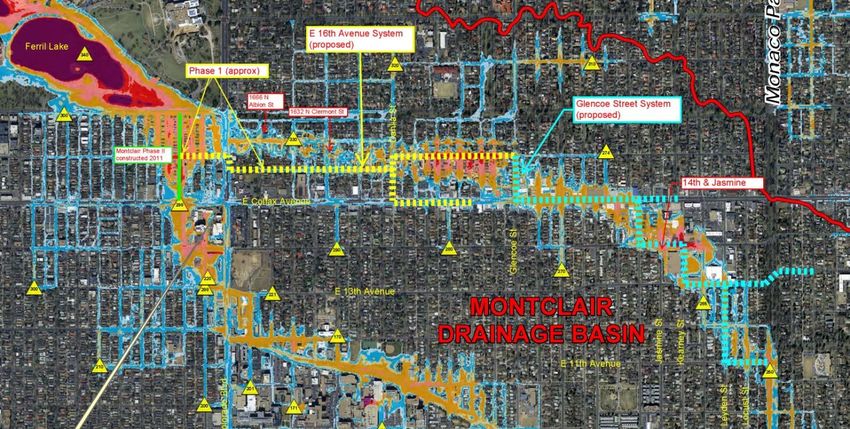
WCPM Project Descriptions for 2016-2021 CIP

E 16th Avenue Street System, Phase 1

 The “E. 16th Avenue Street System-Phase 1” is the first phase in a multi-phase/multi-year effort to
extend and improve the storm drain upstream in the watershed. It will address numerous flooding
issues in the watershed, and capitalize on prior drainage improvements at Ferril Lake (2007-2008) and
“Montclair-Phase 2” storm drain (2011). The first phase would start in the City Park Neighborhood at
16th & Jackson, connecting to the “Montclair-Phase 2” storm drain and continuing eastward as far as
funding allows. Ultimately, per the 2014 Master Plan, the goal for this phase will be to reach
approximately 16th & Albion Street in the South Park Hill Neighborhood, as shown in the map below.
Benefits/Avoided Losses:
Currently, the “Montclair-Phase 2” project does not carry all the runoff that was originally intended in
design since the upstream drainage system improvements are not yet “built-out”.

This project will utilize available capacity in the “Montclair-Phase 2” storm drainage project by
increasing inlet and storm sewer capacity and reducing the flood risk along the Potential Inundation
Areas identified in the City’s 2014 Storm Drainage Master Plan along E. Batavia Place, east of Colorado
Boulevard. Flooding was reported in the South Park Hill Neighborhood at 1666 N. Albion and 1632 N
Clermont (including the alley and back yard) in the July 7, 2011 and June 24, 2014 storms.

This project and its future phases continues the City’s commitment to improving the storm drainage
system in the South Park Hill Neighborhood and further up in the watershed in order to address
repetitive significant flooding upstream in the Montclair Neighborhood at E. 14th Avenue from Jasmine
to Kearney and surrounding properties, as well as the 1100 blocks of Locust and Leyden. Dates of
reported flooding: July 20, 2009, July 11, 2011, September 12, 2013, and June 24, 2015. These
significant flooding locations would ultimately be addressed with the E 16th Avenue Storm System-
Phase 2 improvements and the Glencoe Street System identified in the 2014 Storm Drainage Master
Plan.

Page | 11                                                                            Revised : 2016-06-21
WCPM Project Descriptions for 2016-2021 CIP

E 16th Avenue System, Phase 2

The “E. 16th Avenue Street System-Phase 2” storm drain project further extends and improves the storm
drain system upstream in the South Park Hill Neighborhood in order to address numerous flooding
issues in the watershed, and further capitalize on storm drainage improvements at Ferril Lake (2007-
2008), “Montclair-Phase 2” (2011) and “E. 16th Avenue-Phase 1” (2017-2018). The “E. 16th Avenue-
Phase 2” storm drain would start where Phase 1 ends at approximately 16th & Albion Street and
continue upstream to E. 16th Avenue & N. Glencoe St. It would include a lateral drain in E Colfax Avenue
from Dahlia to Fairfax.

Benefits/Avoided Losses:
The “Montclair-Phase 2” project and “E. 16th Avenue System-Phase 1” storm drains do not collect all the
runoff originally intended in their design since the upstream drainage system improvements are not yet
“built-out”. The “E. 16th Avenue-Phase 2” storm drain will utilize available capacity in the “Montclair-
Phase 2” and “E. 16th Avenue System-Phase 1” storm drainage projects by increasing inlet and storm
sewer capacity. It will reduce the flood risk along the thalweg and major Potential Inundation Areas
identified in the City’s Storm Drainage Master Plan along E. Batavia Place from Colorado Boulevard to N.
Dahlia Street and E. 16th Avenue from N. Dahlia Street to N. Glencoe Street. Flooding was reported in
the South Park Hill Neighborhood at 1666 N. Albion and 1632 N. Clermont (including the alley and back
yard) in the July 7, 2011 storm and the June 24, 2015 storm.

This project, and the future Glencoe Street System, continues the City’s commitment to improving the
storm drainage system further up in the watershed in order to address repetitive significant flooding
upstream in the Montclair Neighborhood where repetitive flooding occurs at E. 14th Avenue from
Jasmine to Kearney and surrounding properties, as well as the 1100 blocks of Locust and Leyden.
Dates: July 20, 2009, July 11, 2011, September 12, 2013, and June 24, 2015.

Page | 12                                                                          Revised : 2016-06-21
WCPM Project Descriptions for 2016-2021 CIP

27th Street Interceptor-Phase 1

Construction of this project would maximize the use of the existing 108” diameter storm drain in the
Coors Field Parking Lot. Currently the tributary drainage area to the existing pipe is only 88 acres. The
new interceptor would start at the existing drain, extending upstream in 27th Street to approximately
Welton Street.

Benefits/Avoided Losses:
The project would capitalize on the investment made in constructing the 108” diameter storm drain in
the Coors Field parking lot in order to maximize the delivery of storm runoff. In doing so, existing storm
drainage systems in the area between 27th and 33rd Streets from Blake to Welton Street would able to
capture more runoff, consistent with the City’s preferred level of service in that area. The new storm
drain would improve drainage in the Five Points Neighborhood and reduce the flood risk at the 27th
Street / Welton Street / Washington Street intersection near the Rossonian Hotel (2650 Welton),
identified as a Significant Flooding Location in the Storm Drainage Master Plan.

This project also provides the ability to extend the storm drainage system upstream to address other
Significant Flooding Locations in the Five Points Neighborhood at 2500 Walnut (at Broadway) and
another extension south in Washington and Clarkson to reach several other Significant Flooding
Locations in the North Capitol Hill Neighborhood between 17th and 19th Avenues / Pearl to Clarkson
Streets.

Page | 13                                                                            Revised : 2016-06-21
WCPM Project Descriptions for 2016-2021 CIP

Lakewood Gulch-Sheridan Phase 2, Construction

The Lakewood Gulch - Sheridan project is a partnership between the City and County of Denver and the
Urban Drainage & Flood Control District between Wolff Street and Sheridan Boulevard on the border
between the Villa Park and West Colfax neighborhoods.

The project will include improvements to Lakewood Gulch to reduce the extent of the 100-year flood
plain, extend the existing multi-use recreation trail, and improve public safety. Along with this project,
there will be substantial amount of land purchases which will be necessary for construction and
maintenance of the gulch. One of these properties to be purchased, a commercial building, will need to
be demolished.

Benefits/Avoided Losses:
The benefits of the project included removing residential structures from the 100-year floodplain,
improving public safety, improving recreational opportunities along gulch, and improving habitat.

Page | 14                                                                            Revised : 2016-06-21
WCPM Project Descriptions for 2016-2021 CIP

Jackson Street System

This project connects to the “Montclair-Phase 2” 14’ wide x 7’ high concrete box storm drain at Colfax
and Jackson Street constructed in 2011 to capitalize on the investment of stormwater detention created
at Ferril Lake in 2007-2008. The “Jackson Street System” extends these storm drain improvements from
East Colfax & Jackson going south/upstream in the Congress Park Neighborhood, crossing Colorado
Boulevard, to E. 12th Avenue & N. Albion Street in the Hale Neighborhood.

Benefits/Avoided Losses:
This project will utilize available capacity in the “Montclair-Phase 2” storm drainage project by
increasing inlet and storm sewer capacity and will reduce the flood risk and Potential Inundation Areas
identified in the City’s 2014 Storm Drainage Master Plan in this area. Currently, the “Montclair-Phase
2” project does not carry all the runoff that was originally intended in design since the drainage system
improvements are not yet “built-out”.

It also continues the City’s commitment to improving the storm drainage system in this watershed in
order to address repetitive significant flooding upstream in the Hale and Montclair Neighborhoods via
the proposed “Hale Parkway System” and the “8th Avenue System” identified in the 2014 Storm
Drainage Master Plan. These future projects would reduce the 100-year Potential Inundation Area
mapped along Hale Parkway and reduce the flood risk of numerous properties at E Severn Place at
Jersey and Jasmine Streets which experienced significant repetitive flooding on August 8, 2008, July 20,
2009, July 11, 2011, and June 24, 2015.

Page | 15                                                                            Revised : 2016-06-21
WCPM Project Descriptions for 2016-2021 CIP

Marion Street System, Phase 1

This storm drain starts at the upstream end of the currently funded 33rd Street Outfall storm drain. The
Phase 1 extension includes a new approximately 8-1/2 foot diameter storm pipe in Marion Street from
Martin Luther King Boulevard, south in Marion Street to E 29th Avenue in the Whittier Neighborhood.

Benefits/Avoided Losses:
Work on this project should begin at the end of the 33rd Street Outfall storm drain and extend upward to
improve the level of drainage service in the basin to address significant flooding reported at E 31st
Avenue & Marion Street on August 13, 2006, and reduce flood risks identified in the Whittier and Five
Points Neighborhoods.

Importantly, this provides the necessary improvements to continue to improve the storm drain system
in future phases and years in order to address additional repetitive significant flooding in the City Park
West Neighborhood including condominiums at E 17th Avenue & Lafayette, E 17th Avenue & Franklin, E
16th & Williams, and E Colfax Avenue at Williams & High Streets.

Page | 16                                                                             Revised : 2016-06-21
WCPM Project Descriptions for 2016-2021 CIP

Oneida & Tennessee to Cherry Creek, Phase 1

This project includes a box culvert outfall starting at Cherry Creek and extending upstream into the basin
in E. Tennessee Street to the sump area at Oneida Street in order to provide 100-year flood protection
at the sump at S Oneida & E Tennessee and includes a new 48-inch lateral in S. Oneida Street. The total
project cost is roughly $12M.

Benefits/Avoided Losses:
Felsburg Holt & Ullevig prepared the February 9, 2011 Tennessee & Oneida Storm Drainage
Alternatives Study. In the report, an 84-inch outfall, following E. Tennessee Avenue, is the shortest and
the most cost effective alternative. It would alleviate repetitive flooding in the sump at S Oneida & E
Tennessee (2002, 8-8-2008, 6-25-2009), as well as flooding issues at 1000 S Monaco Street Parkway.

Page | 17                                                                           Revised : 2016-06-21
WCPM Project Descriptions for 2016-2021 CIP

Park Hill System, Phases VI & 38th Avenue – Dahlia to Holly

This project extends the work that was previously completed in the first five phases of the Park Hill
System, including the currently funded Park Hill Phase V. Phases VI will extend the storm sewer from
the intersection of E Smith Rd and N Dahlia St south along N Dahlia to its intersection with E 38th
Avenue. Phase VII will extend from the end of Phase VI at N Dahlia and E 38th to the detention basin at
38th and Holly.

Benefits/Avoided Losses:
This project will provide a greater level of protection to the Park Hill area, and is part of the
infrastructure necessary to eventually mitigate the significant flooding locations at 4801 E MLK Blvd (at
Eudora) and 3340 N Olive St.

                                                      Park Hill Phase V
                                                      (part of TBDP)

                                                      (Part of TBDP)

                                                        Park Hill Phase VI

                                                        (Part of TBDP)

                                                        38th Avenue –
                                                        Dahlia to Holly

                                                         0

Page | 18                                                                            Revised : 2016-06-21
WCPM Project Descriptions for 2016-2021 CIP UDFCD Study: Sloan’s Lake MDP and FHAD Update This is to update the Urban Drainage and Flood Control District (UDFCD) 1977 Sloan’s Lake Major Drainageway Plan (MDP) and Flood Hazard Area Delineation (FHAD) mapping. Funding represents the City’s share of the Study which would be managed by the UDFCD. The study would correct a technical error found in the 1977 MDP, evaluate water quality and sedimentation in Sloan’s Lake, and re-evaluate the current flood hazard area in northwest Denver from Sloan’s Lake to the South Platte River, including impacts at Colfax & Federal and the Mile High Stadium parking lot. Benefits/Avoided Losses: This provides up-to-date estimated 100-year flood flow rates and identifies alternative solutions to reduce flood risk and improve water quality using updated technologies and improvements. This will improve water quality entering Sloan’s Lake from the west and better identify flood risks downstream of Sloan’s Lake. Projects identified in the updated plan are eligible for cost-sharing between the UDFCD and the City. Page | 19 Revised : 2016-06-21
WCPM Project Descriptions for 2016-2021 CIP

UDFCD Study: Lakewood Gulch MDP and FHAD

This is to update the Urban Drainage and Flood Control District (UDFCD) and City’s 1979 Major
Drainageway Planning for Lakewood Gulch. Funding represents the City’s share of the Study, which
would be managed by the UDFCD.

Benefits/Avoided Losses:
This provides up-to-date estimated 100-year flood flow rates and identifies alternative solutions to
reduce flood risk and improve water quality using updated technologies and improvements.

 Areas of particular concern include significant flooding locations at the Knox Ct culvert crossing and the
Perry culvert/bridge crossing along the gulch. Additionally, the project will focus on removing structures
from within the 100-year floodplain.

Projects identified in the updated plan are eligible for cost-sharing between the UDFCD and the City.

Page | 20                                                                            Revised : 2016-06-21
WCPM Project Descriptions for 2016-2021 CIP

UDFCD Study: Goldsmith Gulch MDP and FHAD Update

This is to update the Urban Drainage and Flood Control District (UDFCD) 1977 Goldsmith Gulch Major
Drainageway Plan (MDP) and Flood Hazard Area Delineation (FHAD) mapping. Funding represents the
City’s share of the Study which would be managed by the UDFCD.

Benefits/Avoided Losses:
This provides up-to-date estimated 100-year flood flow rates and identifies alternative solutions to
reduce flood risk and improve water quality using updated technologies and improvements.

 Areas of particular concern include the underground portion of Goldsmith Gulch beneath the Tiffany
Plaza parking area south of Hampden Avenue; improving function of the Iliff & Monaco Detention pond;
removing properties in the 100-year floodplain between E Iliff Avenue and E Evans Avenue, including the
low area in S Monaco Street Parkway south of E Evans Avenue; and the 100-year floodplain running
down S Monaco Street Parkway.

Projects identified in the updated plan are eligible for cost-sharing between the UDFCD and the City.

Page | 21                                                                           Revised : 2016-06-21
WCPM Project Descriptions for 2016-2021 CIP

UDFCD Study: Irondale Gulch OSP update

This is to update the Urban Drainage and Flood Control District (UDFCD) 1990 Irondale Gulch
Stormwater outfall Systems Plan (OSP) in a cost-share partnership between the UDFCD, City of Aurora,
and the City and County of Denver. The previous study noted that “the Montbello area currently suffers
from a lack of adequate capacity for major floods. The existing channels have the capacity of around the
5- to 10-year flood.”

Benefits/Avoided Losses:
This provides up-to-date estimated 100-year flood flow rates and identifies alternative solutions to
reduce flood risk and improve water quality using updated technologies and improvements

Projects identified in the updated plan are eligible for cost-sharing between the UDFCD and the City.

Page | 22                                                                           Revised : 2016-06-21
WCPM Project Descriptions for 2016-2021 CIP

UDFCD Study: Sand Creek (downstream of Colfax) MDP & FHAD

In 2012, the UDFCD completed a Major Drainageway Plan (MDP) and Flood Hazard Area Delineation
FHAD) for Sand Creek from E Yale Avenue to E Colfax Avenue. This is to extend that study from Colfax
to the South Platte River in a cost-share partnership between the UDFCD and the City and County of
Denver with possible contributions from the Cities of Aurora and Commerce City.

Benefits/Avoided Losses:
The September 2013 storms produced flood damages along Sand Creek within Denver and Commerce
City. This provides up-to-date estimated 100-year flood flow rates and identifies alternative solutions to
reduce flood risk and improve water quality using updated technologies and improvements.

The majority of the City Jail at Smith Road and Havana is in the floodplain. There are also erosion
concerns along the creek and possible property and critical infrastructure impacts.

Projects identified in the updated plan are eligible for cost-sharing between the UDFCD and the City.

Page | 23                                                                            Revised : 2016-06-21
WCPM Project Descriptions for 2016-2021 CIP

UDFCD Study Local Match

This is place-holder funding for cost-sharing on future studies with the Urban Drainage and Flood
Control District that are of benefit to the City and County of Denver. The UDFCD Planning budget looks
at the next 4 years, whereas the City’s Storm Capital Improvement Program budget has a 6-year time
horizon.

Benefits/Avoided Losses:
This it to ensure that the City’s share (maximum $100,000) for UDFCD studies beyond the 4-year budget
cycle of the UDFCD is included in the fiscally-constrained cash-flow model. The City share does not
exceed $100,000 in any given year. Including this in the cash-flow model ensures continued
collaboration with the UDFCD on planning studies which evaluate the adequacy of major streams and
gulches within the City and recommend improvements, if needed.

Page | 24                                                                         Revised : 2016-06-21
WCPM Project Descriptions for 2016-2021 CIP

UDFCD CIP: Cherry Creek Stabilization-Holly to Iliff

This is an ongoing cost-shared project between the City and the Urban Drainage and Flood Control
District (UDFCD) to improve streambed stability to Cherry Creek by the UDFCD. The UDFCD is moving
quickly to address stabilization measures (drop structures and stream-bank protection) in the Holly to
Iliff segment.

Total project cost is estimated to be $12.1 million for the Cherry Creek stabilization measures. Of this
total, $10.6 million is within the jurisdiction of the City & County of Denver, and $1.5 million is within the
jurisdiction of Arapahoe County. The Capital Improvement Project budget is for the City of Denver share
over multiple years.

Benefits/Avoided Losses:
In some areas, the streambed has dropped 10 feet, creating an unstable streambed and stream banks, a
safety risk for users of the corridor, and the near-loss of the Cherry Creek Bike Trail, the most heavily
used bike trail in the City. It will improve accessibility to the Creek, habitat along the creek and also
improve water quality by reducing erosion and downstream deposition.

Page | 25                                                                               Revised : 2016-06-21
WCPM Project Descriptions for 2016-2021 CIP

UDFCD CIP: Bowles Ditch Separation

This project is a cost-shared project with the Urban Drainage and Flood Control District recommended in
the May 2012 Marston Lake North Major Drainageway Plan located in the Marston Neighborhood in
Southwest Denver. The purpose of the project is to eliminate storm water from areas south of the
Bowles Lateral irrigation ditch owned by the Joseph W. Bowles Reservoir Company.

Benefits/Avoided Losses:
Eliminate storm runoff from entering the private irrigation ditch, improve water quality, reduce liability,
and improve safety.

Page | 26                                                                             Revised : 2016-06-21
WCPM Project Descriptions for 2016-2021 CIP

UDFCD CIP: Marston Lake North Drainageway MDP Implementation (Reaches 7, 8
and 9)

This project is a cost-shared project with the Urban Drainage and Flood Control District recommended in
the Marston Lake North Major Drainageway Plan and Flood Hazard Area Delineation study located in the
Marston Neighborhood in Southwest Denver. The project would lower the existing channel and
improve culverts crossing local streets.

Benefits/Avoided Losses:
The purpose of the project is to create water quality in the existing low area within Stanford & Balsam
Park and improve the existing flood control channel and street crossings located between approximately
S Dudley Street and South Garrison Street in order to remove 13 homes from the flood plain.

Page | 27                                                                         Revised : 2016-06-21
WCPM Project Descriptions for 2016-2021 CIP

FEMA Grant: Sanderson Gulch, Reach 1

The existing South Platte River Drive culvert, open drainage channel, railroad bridge, and Lipan Street
box culvert, all within a 900-foot section of Sanderson Gulch are undersized during flood events greater
than or equal to a 10-year rain storm event. Currently during rain storm events equal to or greater than
a 10-year, floodwaters backup into the drainage channel and overtop in the vicinity of the confluence
with the South Platte River. The project will entail widening the channel within the existing right-of-way
in order to remove properties from the flood plain.

Benefits/Avoided Losses:
This project results in removing 94 industrial, commercial, and residential properties, including 28 with
active National Flood Insurance Program (NFIP) policies from within the boundary of the 100-year
floodplain.

Page | 28                                                                            Revised : 2016-06-21
WCPM Project Descriptions for 2016-2021 CIP

USACE Study/Design: CAP Program-River South

The US Army Corps of Engineers (USACE) and Denver have committed to partner in a study of the South
Platte River between Dartmouth and Alameda (River South - RISO) to identify ecosystem, habitat and
floodplain benefits along this corridor. The design is anticipated to cost $1M-$2M at a 50/50 match.
Identified projects would be eligible for federal funding through the Corps' Section 1135 Continuing
Authorities Program (CAP). CAP projects have a 65/35 match (federal/local) up to a total project
amount of $12M.

A federal interest review is tentatively scheduled for 2015 with the year-long study to follow
immediately after in 2016. Pending proper federal authorities, a one to two year design for one of the
identified reaches would commence circa 2017, followed by construction in 2019-2020.

Benefits/Avoided Losses:

Potential benefits include continued improvement of the South Platte River's southern corridor where
$25M-plus has already been invested by the city and others since 2007. An improved ecosystem and
habitat benefit, flood risk reduction, recreation, connectivity and water quality.

Page | 29                                                                          Revised : 2016-06-21
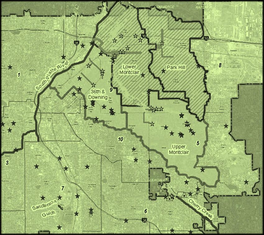
WCPM Project Descriptions for 2016-2021 CIP

USACE Implementation – SPR & Gulches

BR13-0613 approves an agreement with the US Army Corps of Engineers (USACE) for a three-year, $3M
Feasibility Study, with Denver contributing $1,500,000 from the Wastewater Capital Fund, for the South
Platte River from 6th Ave to 58th Ave (RINO), Weir Gulch, and Harvard Gulch in Denver to identify
potential ecosystem restoration and/or flood risk reduction projects. Projects would then be eligible for
up to 65% federal funding with USACE.

Benefits/Avoided Losses:

Potential benefits include reducing flood risk reduction, ecosystem & habitat restoration, water quality,
recreation and connectivity improvements along the river & gulches.

Page | 30                                                                            Revised : 2016-06-21
WCPM Project Descriptions for 2016-2021 CIP

Page | 31                          Revised : 2016-06-21
WCPM Project Descriptions for 2016-2021 CIP

Page | 32                          Revised : 2016-06-21
WCPM Project Descriptions for 2016-2021 CIP
USACE Implementation – SPR & Gulches (cont.)
BR13-0613 approves an agreement with th US Army Corps of Engineers (USACE) for a three-year, $3M
Feasibility Study, with Denver contributing $1,500,000 from the Wastewater Capital Fund, for the South
Platte River from 6th Ave to 58th Ave (RINO), Weir Gulchu, and Harvard Gulch in Denver to identify
potential ecosystem restoration and/or flood risk reduction projects. Projects would then be eligible for
up to 65% Federal funding with USACE.
Benefits/Avoided Losses:
Potential benefits include reducing flood risk reduction, ecosystem & habitat restoration, water quality,
recreation and connectivity improvements along the river & gulches.
Possible Harvard Gulch Alternative
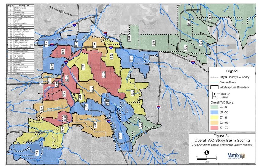
Page | 33 Revised : 2016-06-21WCPM Project Descriptions for 2016-2021 CIP Regional Water Quality Project Development The Water Quality program provides a means to construct facilities to reduce pollutants in stormwater runoff and meet the current TMDL for E. coli that exists on the South Platte River, as well as future regulations for nutrients. The implementation program provides annual funding for planning and feasibility studies of water quality initiatives that build a robust and innovative stormwater program. Water quality facilities, also known as green infrastructure, provide other citywide benefits including increased open space, heat island mitigation, improved air quality, and linkages for connectivity in urban corridors. Below is a draft priority basin map: Page | 34 Revised : 2016-06-21
WCPM Project Descriptions for 2016-2021 CIP

Regional Water Quality Construction
The Water Quality program provides a means to construct facilities to reduce pollutants in stormwater
runoff and meet the current TMDL for E. Coli that exists on the South Platte River and future regulations
for nutrients.

Water quality facilities, also known as green infrastructure, provide other citywide benefits including
increased open space, heat island mitigation, improved air quality, and linkages for connectivity in urban
corridors.

The construction program provides funding for the construction of water quality facilities based upon
opportunities defined in the Water Quality Implementation Plan (Scorecard).

Page | 35                                                                           Revised : 2016-06-21
WCPM Project Descriptions for 2016-2021 CIP

Public Restrooms Program
Public Restrooms Program is a citywide initiative to provide public restroom facilities in strategic
locations around the city. A public health, safety, and water quality benefit is anticipated with the
construction and use of these facilities.

                 Photo of public facility in Northern Ireland; For depiction purposes only

Page | 36                                                                             Revised : 2016-06-21
WCPM Project Descriptions for 2016-2021 CIP Capital Project Support - Annual Annual project for repairs, rehabilitation, and pre-construction activities on capital projects to support timelines and schedules. Page | 37 Revised : 2016-06-21
WCPM Project Descriptions for 2016-2021 CIP

General Sanitary Improvements

This is an annual sanitary sewer program to improve deteriorated gravity-drained sanitary sewer pipes
using either “open trench” digging methods or lining existing sanitary sewers. Each project is evaluated
based on site-specific needs in order to determine the most cost effective methods. Wherever possible,
lining technologies are used, which reduces construction time as compared with open trench methods.
Since no excavation is required, utilities and traffic conflicts are minimized; thereby citizen discomfort
and complaints are reduced to a minimum. The locations for this rehabilitation are throughout the City
of Denver. This project will line approximately 75,000 feet of liner of various sizes.

Benefits/Avoided Losses:
The benefit of this program is to extend the life of the city sanitary system through cost-effective
methods that minimize the impact to the citizens of Denver. A second benefit is to improve water and
groundwater quality by lining existing sanitary systems that have cracks and may be leaking.

Page | 38                                                                           Revised : 2016-06-21
WCPM Project Descriptions for 2016-2021 CIP

Sanitary Project Development - Annual

This provides “seed money” for project development work and tasks related to sanitary sewer projects
in the 6-year Capital Improvement Program that are budged in a future fiscal year, but for which scoping
analysis is needed now. This work includes engineering studies, utility locates & dig-ups, environmental,
professional services, etc.

Benefits/Avoided Losses:
This allows issues to be investigated prior to design in order to improve the formal design process of
future-funded sanitary projects.

Page | 39                                                                            Revised : 2016-06-21
WCPM Project Descriptions for 2016-2021 CIP

Sanitary Master Plan Updates

Sanitary Master Plan Update projects are planning, design, implementation and/or grant initiatives
typically related to partnerships with other agencies, like Metro Wastewater or RTD, whereby a project
is co-funded and co-sponsored with mutual benefits for all parties involved.

Benefits/Avoided Losses:
The goals of these projects are similar to both Annual and Discretionary projects, to provide necessary
improvements to the identified needed locations to restore the existing system in place and/or increase
the system's capacity to meet a future need.

Page | 40                                                                          Revised : 2016-06-21
WCPM Project Descriptions for 2016-2021 CIP

E Cherry Creek Sanitary Upsizing

This project has been scoped to upsize the existing interceptor in Bayaud Avenue. Redevelopment
activity in the neighborhoods east of the Cherry Creek Shopping District has increased unit density and
triggered a need for existing system upsizing.

Benefits/Avoided Losses:
The goal of this project is to provide expanded service in a rapidly developing area of the City.

Page | 41                                                                             Revised : 2016-06-21
WCPM Project Descriptions for 2016-2021 CIP

49th Avenue, Phase 2 Sanitary

The 2nd phase of the NDCC Interceptor improvements would continue a new line east in 49th Avenue to
collect the 600-acres and that currently heads north to Lift Station 5.

Benefits/Avoided Losses:
This will lower operating costs and provide for flexibility in managing increased flow from the
redevelopment of properties served by the interceptor.

Page | 42                                                                            Revised : 2016-06-21
WCPM Project Descriptions for 2016-2021 CIP

York Street Sanitary Improvements

This project is the future phase of the NDCC Interceptor upsize. It will build the pipe to make a new
connection to the line in York Street. This project will reduce the tributary properties by 40%.

Benefits/Avoided Losses:
The reduced flow to Lift Station 5 will lower operating costs and provide additional flexibility for the
development of the NDCC area.

Page | 43                                                                              Revised : 2016-06-21
You can also read