Bedminster Statistical Ward Profile 2020 - May 2020 - Bristol City Council
←
→
Page content transcription
If your browser does not render page correctly, please read the page content below
Bedminster
                                                            Statistical Ward
                                                                       Profile
                                                                        2020
                                                                         May 2020

Insight, Performance and Intelligence Service, Bristol City Council
www.bristol.gov.uk/statistics - email: research@bristol.gov.uk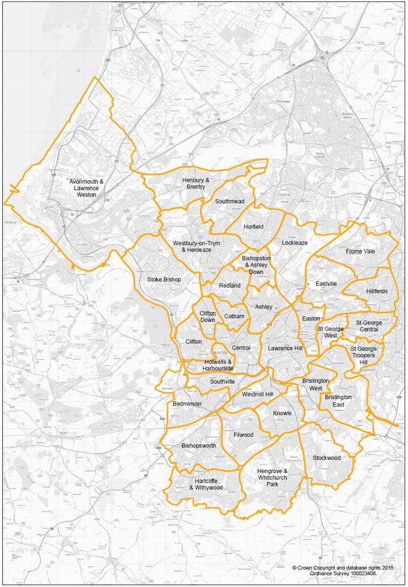
CONTENTS - HELP PAGE
 These 2020 Ward Profiles have been compiled for Bristol City Council wards using latest data as of May 2020. This
 update publishes new quality of life, healthy lifestyles, life expectancy, premature mortality, child poverty, crime and
 social care data, along with some updates to the education data. This interactive tool provides data for each of the
 wards and for Bristol overall, highlighting any significant differences for the relevant ward compared to the Bristol
 average. The tool is designed to allow users to copy pages into other reports, to provide local evidence. There is also
 a suite of individual Ward Profile reports. See
                                            www.bristol.gov.uk/wardprofiles
 Contents
     Page 3    Population - ONS 2018                           Page 19    Mapping Tools
     Page 4    Deprivation - 2019                              Page 20    Sources (p1)
     Page 5    Quality of Life (p1) - 2019-20                  Page 21    Sources (p2)
     Page 6    Quality of Life (p2) - 2019-20                  Page 22    Ward Names
     Page 7    Healthy Lifestyles - 2019-20                    Page 23    Ward Boundary Map
     Page 8    Life Expectancy - 2016-2018
     Page 9    Premature Mortality - 2016-2018
    Page 10    Child Poverty 2018-19
    Page 11    Crime - 2019-20
    Page 12    Education - 2019
    Page 13    Social Care 2020
    Page 14    Housing - Census 2011
    Page 15    Household Size - Census 2011
    Page 16    Car Availability - Census 2011
    Page 17    Ethnicity - Census 2011

 Help / Notes
 1/ The 34 Bristol Wards (established in 2016) are listed in blue down the left hand margin. Click the box to change
 ward.
 2/ The Indicator pages are in orange down the right hand margin. There are 16 pages of data. Click the box            to
 change indicator.
 3/ Full details, definitions and sources for each indicator are noted in the Sources pages.
 4/ Many pages have infographics to highlight a key indicator(s), with other indicators listed below.
 5/ Several pages includes a chart ranking all wards, with the chosen ward noted in a different colour.
 6/ The tool shows the current latest data. It does not show past trend data.
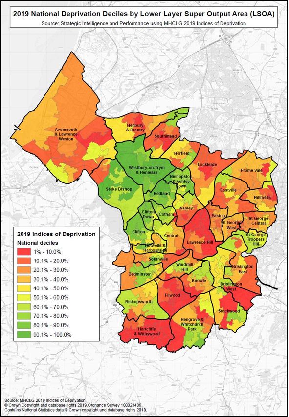
 7/ For Deprivation and Child Poverty, the data is shown by LSOA (Lower Super Output Area) not ward.
 8/ The rating uses statistical confidence intervals or t-tests to identify if the gap is statistically significant. Different
 wards and data-sets have different size confidence intervals, so trigger points for the below colour ratings will
 vary.
 9/ All indicators are colour-coded to show any significant difference between the ward and the city average. These

Significantly Better than the city average                       Significantly Higher than the city average

Not Significantly Different for the city                         Significantly Lower than the city average

Significantly Worse than the city average

 Insight, Performance and Intelligence Service, Bristol City Council                   www.bristol.gov.uk/statistics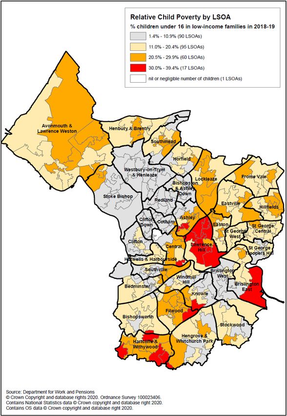
POPULATION ESTIMATE Office for National Statistics 2018
BEDMINSTER
                      Bedminster (population 12,500)                                                                      Significantly High
                                                                                                                  Not Significantly Different
                      Bristol
                                                                                                                           Significantly Low

AGE GROUPS
                                   15.3%                                                                      16.8%
 0-15                                                                   40-54
                                       18.5%                            years                                 16.8%
years

                           9.1%                                                                  8.6%
16-24                                                                   55-64
years                               15.8%                                                        8.9%
                                                                        years

                                                               36.7%                                      13.6%
25-39                                                                    65 +
years                                             27.1%                                                   12.9%
                                                                        years

POPULATION PYRAMID                                                     WARD COMPARISON
                                                                               Children             Working Age             Older People

    90+                                                                                       Ashley
   85-89                                                       Avonmouth & Lawrence Weston
                                                                                       Bedminster
   80-84                                                            Bishopston & Ashley Down
   75-79                                                                            Bishopsworth
                                                                                  Brislington East
   70-74
                                                                                 Brislington West
   65-69                                                                                    Central
   60-64                                                                                     Clifton
                                                                                    Clifton Down
   55-59                                                                                   Cotham
   50-54                                                                                     Easton
           Age

                                                                                            Eastville
   45-49                                                                                    Filwood
   40-44                                                                               Frome Vale
                                                                        Hartcliffe & Withywood
   35-39
                                                                             Henbury & Brentry
   30-34                                                          Hengrove & Whitchurch Park
                                                                                            Hillfields
   25-29
                                                                                            Horfield
   20-24                                                                Hotwells & Harbourside
   15-19                                                                                    Knowle
                                                                                    Lawrence Hill
   10-14                                                                                 Lockleaze
     5-9                                                                                   Redland
                                                                                      Southmead
     0-4                                                                                  Southville
                                                                             St George Central
           20         10               0          10           20       St George Troopers Hill
                                  Percentage                                     St George West
                                                                                       Stockwood
                                                                                     Stoke Bishop
           Bedminster Males                                      Westbury-on-Trym & Henleaze
           Bedminster Females                                                          Windmill Hill

           Bristol Males                                                                                 0K             10K              20K
           Bristol Females                                                                                         Population

Population – Source: Bristol City Council using ONS 2018 Small Area Population Estimates ONS © Crown Copyright
See source pages for further details
 Insight, Performance and Intelligence Service, Bristol City Council                                www.bristol.gov.uk/statistics
DEPRIVATION Indices of Multiple Deprivation 2019
BEDMINSTER

                                                                                       Most deprived 10% in England

       For further information about the deprivation indices, including scores, ranks and maps, please
       refer to ‘Deprivation in Bristol 2019’ report - www.bristol.gov.uk/deprivation
       LSOA maps can be found on Pinpoint http://maps.bristol.gov.uk/pinpoint/

Source: MHCLG English Indices of Deprivation 2019

 Insight, Performance and Intelligence Service, Bristol CityCouncil             www.bristol.gov.uk/statistics
QUALITY OF LIFE 1Quality of Life Survey 2019-20
BEDMINSTER
Significantly Better Significantly Worse Not Significantly Different
Significantly High Significantly Low
Bedminster Bristol
% satisfied with the way the Council runs things 53 43
Council & Democracy
% who feel Bristol City Council provides value for money 32 28
% who feel an elected mayor is improving the leadership of the city 26 23
% who agree they can influence decisions that affect their local area 27 18
% who agree they can influence decisions that affect the public services they
22 15
use
% satisfied with life 82 75
% in good health 90 88
% below average mental wellbeing 14 15
Health & Wellbeing
% who see friends and family as much as they want to 83 82
% who do enough regular exercise each week 74 71
% who play sport at least once a week 42 46
% households with a smoker 20 17
% people at a higher risk of alcohol related health problems 21 16
% households which have experienced moderate to severe food insecurity 4 5
% whose fear of crime affects their day-to-day lives 11 16
Crime &
Safety
% who feel police and public services successfully tackle crime and anti-social
32 28
behaviour locally
% who think domestic abuse is a private matter 7 7
% who feel they belong to their neighbourhood 72 62
% who agree people from different backgrounds get on well together in their
neighbourhood 76 71
% who volunteer or help out in their community at least 3 times a year 47 48
% who have access to the internet at home 98 95
Community & Living
% comfortable using digital services 81 82
% who lack the information to get involved in their community 32 28
% who think noise from residential neighbours is a problem 22 33
% who find it difficult to manage financially 6 9
% satisfied with their local area 90 79
See source pages for further details
Insight, Performance and Intelligence Service, Bristol City Council www.bristol.gov.uk/statisticsQUALITY OF LIFE 2 Quality of Life Survey 2019-20 Bristol Quality of Life
BEDMINSTER
Significantly Better Significantly Worse Not Significantly Different
Significantly High Significantly Low
Bedminster Bristol
% who need to develop at least one of their skills
Education &
24 30
Skills
% who know where to get information, advice and guidance about employment
63 61
and training
% satisfied with adult learning opportunities 27 32
% who think traffic congestion is a problem locally 83 77
% who think air quality and traffic pollution is a problem locally
Transport
84 77
% who ride a bicycle at least once a week 31 28
% satisfied with the local bus service 59 48
% satisfied overall with their current accommodation 92 88
Housing
% satisfied with the state of repair of their home 85 81
% satisfied with the cost of their rent or mortgage payments 57 59
% who think street litter is a problem locally 81 81
% satisfied with the general household waste service 76 71
Sustainability & Environment
% satisfied with the quality of parks and green spaces 79 72
% who visit Bristol's parks and green spaces at least once a week 56 53
% satisfied with the recycling service 70 68
% concerned about climate change 95 88
% who have reduced flying for holidays due to climate change concerns 31 25
% who have reduced their household waste due to climate change concerns 79 69
% who have reduced energy use at home due to climate change concerns 63 57
% satisfied with the range and quality of outdoor events 80 74
Culture & Leisure
% satisfied with activities for children/young people 38 37
% who participate in cultural activities at least once a month 45 43
% satisfied with libraries 40 54
% satisfied with leisure facilities/services 45 46
See source pages for further details
Insight, Performance and Intelligence Service, Bristol City Council www.bristol.gov.uk/statisticsHEALTHY LIFESTYLES Quality of Life Survey 2019-20
BEDMINSTER
Significantly Better
% who say they are in good health Not Significantly Different
Significantly Worse
Bedminster 90 88 Bristol
90 Bristol Average 87.6
%
70
50
St G Troopers Hill
Stoke Bishop
Hillfields
Bishopsworth
Bris East
St G Central
Easton
Bris West
Windmill Hill
Central
Lawrence Hill
Horfield
Hotwells & H'side
Southville
Frome Vale
Ashley
Knowle
Southmead
Stockwood
Bedminster
Henbury & Brentry
WoT & Henleaze
Eastville
Filwood
Redland
Clifton
St G West
Clifton Down
Hengrove & WhitPk
Lockleaze
Hartcliffe & Wwood
Cotham
B'ston & AshDown
A'mouth & LW
Results from the Quality of Life survey 2019-20
Bedminster Bristol
% with illness or health condition which limits day-to-day activities 29 26
% above average mental wellbeing 15 10
% households where someone smokes regularly within the home 6 4
% who cook a 'ready meal' once a week at most 87 84
% who do enough regular exercise each week 74 71
% overweight or obese 36 45
Public Health National Child Measurement Programme 2016/17 - 2018/19
% children in reception (4/5yr olds) who have excess weight 22.7 22.7
% children in year 6 (10/11yr olds) who have excess weight 26.1 32.8
See source pages for further details
Insight, Performance and Intelligence Service, Bristol City Council www.bristol.gov.uk/statistics50
55
70
75
80
50
65
70
85
90
95
60
65
85
90
55
60
75
80
*
Hotwells & H'side Clifton
Males
Cotham Hotwells & H'side
Females
Clifton Cotham
WoT & Henleaze Central
B'ston & AshDown WoT & Henleaze
Bristol males
Bris East Redland
Bristol females
BEDMINSTER
Stoke Bishop B'ston & AshDown
Three Year Averages
Bedminster males
Redland Bris East
Bedminster females
Clifton Down Knowle
Horfield Clifton Down
Ashley Eastville
Frome Vale Henbury & Brentry
Hengrove & WhitPk Windmill Hill
Henbury & Brentry Stoke Bishop
Bishopsworth Bris West
Knowle Bishopsworth
St G Troopers Hill Frome Vale
77.4
78.4
Hillfields Hillfields
Insight, Performance and Intelligence Service, Bristol City Council
Stockwood Ashley
These figures are averages of a 3 year period. See source pages for further details
82.0
Eastville Hengrove & WhitPk
82.6
Windmill Hill St G West
A'mouth & LW Lawrence Hill
Bris West Bedminster
Central Horfield
LIFE EXPECTANCY Public Health 2016-2018
Bedminster A'mouth & LW
Southmead Stockwood
Easton St G Troopers Hill
St G Central Filwood
Lockleaze Lockleaze
Filwood Southmead
Hartcliffe & Wwood Easton
www.bristol.gov.uk/statistics
St G West Southville
Due to the small numbers involved female life expectancy in Hotwells & Harbourside is calculated over 2014-2018.
Not Significantly Different
Significantly Worse
Significantly Better
Southville Hartcliffe & Wwood
Bristol Average 82.6
Bristol Average 78.4
Lawrence Hill St G CentralPREMATURE MORTALITYPublic Health 2016-2018
BEDMINSTER
Three Year Averages
All Causes
Directly age standardised rates for deaths in people aged under 75 Significantly Better
years, per 100,000 population Not Significantly Different
Significantly Worse
Bedminster 495.8 388.0 Bristol
600
500
Bristol Average 388.0
400
Deaths
300
200
100
0
Hotwells & H'side
St G Central
Bris West
Bedminster
Henbury & Brentry
WoT & Henleaze
Hengrove & WhitPk
Eastville
St G West
Ashley
Knowle
Stockwood
Frome Vale
Hartcliffe & Wwood
Clifton
Filwood
Easton
Horfield
B'ston & AshDown
Cotham
Central
Lockleaze
A'mouth & LW
Hillfields
Clifton Down
Southmead
Redland
Bris East
Southville
Windmill Hill
Stoke Bishop
Bishopsworth
Lawrence Hill
St G Troopers Hill
Selected Causes
Directly age standardised rates for deaths in people
aged under 75 years, per 100,000 population
Bedminster Bristol
Cancer 211.8 154.4
Cardiovascular Disease 92.2 77.7
Respiratory Disease 54.3 40.2
These figures are averages of a 3 year period. However, due to the smaller numbers involved figures for respiratory disease have been
calculated over the 5 year period 2014-2018. See source pages for further details
Insight, Performance and Intelligence Service, Bristol City Council www.bristol.gov.uk/statisticsCHILD POVERTY Children living in low income families 2018-19 This is a new measure of the percentage of children living in low income families, mapped by small areas (called “Lower Super Output Areas” or LSOAs), with the Bristol ward boundaries added on top. A family must have claimed one or more of Universal Credit, Tax Credits or Housing Benefit at any point in the year to be classed as low income in these statistics. Insight, Performance and Intelligence Service, Bristol City Council www.bristol.gov.uk/statistics
CRIME Crime and Policing 2019-20 Significantly Better
Not Significantly Different
BEDMINSTER Significantly Worse
Selected Offence Rates
(per 1,000 population) 2019-20 Bedminster Bristol
96.0 113.5
All Crime
Violent &
Burglary Sexual 8.2 28.2 6.7 37.5
Offences
Anti Social 17.7 29.7
Behaviour
500 All Crime Offence Rate (per 1,000 population) 2019-20
450
400
350
300
250
200 Bristol Average 113.5
150
100
50
0
Hengrove &…
Hartcliffe &…
Henbury & Brentry
Bedminster
Bris West
WoT & Henleaze
Frome Vale
Stockwood
Ashley
Knowle
B'ston & AshDown
Eastville
Lockleaze
Filwood
Easton
Clifton Down
Clifton
Cotham
St G West
Central
Southmead
St G Central
Horfield
Bishopsworth
St G Troopers Hill
Hillfields
Redland
A'mouth & LW
Bris East
Stoke Bishop
Southville
Windmill Hill
Lawrence Hill
Hotwells & H'side
Results from youth offending team - Rate of Offenders (per 1,000 10 -17 year olds) 2019-20
Youth
Offences 4.2 6.3
Results from the Quality of Life survey 2019-20 Bedminster Bristol
% who feel anti-social behaviour is a problem locally 35 33
% who feel safe outdoors after dark 72 67
% who have been a victim of crime in the last 12 months 16 13
Sources: 1. Selected Offence Rates 2019-20 from www.police.uk . 2. Youth offending data from Youth Offending Team, Bristol City Council
3. Quality of Life Survey from Bristol City Council
See source pages for further details
Insight, Performance and Intelligence Service, Bristol City Council www.bristol.gov.uk/statisticsEDUCATION Bristol City Council / Dept for Education 2019
BEDMINSTER
Significantly Better
Significantly Worse
Attainment 8 - average achievement score
Not Significantly Different
Significantly High
Significantly Low
Bedminster 39.2 44.2 Bristol
100
75
Bristol Average 44.2
Attainment 8 Score
50
25
0
Henbury & Brentry
Stockwood
Bedminster
Hartcliffe & Wwood
B'ston & AshDown
Frome Vale
Knowle
Bishopsworth
Clifton
Ashley
Lockleaze
Clifton Down
Redland
St G West
Filwood
Bris East
Bris West
Hillfields
Easton
Central
Cotham
Stoke Bishop
Horfield
Southmead
St G Troopers Hill
A'mouth & LW
Southville
St G Central
Windmill Hill
Lawrence Hill
Eastville
WoT & Henleaze
Hengrove & WhitPk
Hotwells & H'side
Education Indicators 2019
Bedminster Bristol Bedminster Bristol
Progress 8 - average progress
Free School Meals % 10.9 20.3 score (KS2 to KS4) across 8 -0.50 -0.07
subjects
Early years pupils achieving a
Disadvantaged % 14.3 27.7 77.0 70.7
good level of development %
Special Educational Needs KS2 reaching expected
13.9 15.4 68.8 64.1
% standard RWM combined %
English as an Additional 11.0 20.9 8.2 7.2
Absence rate %
Language %
Source: Insight, Performance and Intelligence, Bristol City Council
See source pages for further details
Insight, Performance and Intelligence Service, Bristol City Council www.bristol.gov.uk/statisticsSOCIAL CARE Adult Social Care 2020
BEDMINSTER
Clients receiving a community based service aged Significantly Better
65+ (rate per 1000) Significantly Worse
Not Significantly Different
Significantly High
Significantly Low
Bedminster 39.9 31.6 Bristol
100
80
60
Clients (per 1000)
Bristol Average 31.6
40
20
0
Hartcliffe & Wwood
Frome Vale
Knowle
Lockleaze
Clifton Down
Ashley
Bishopsworth
Clifton
St G West
Filwood
Bris East
St G Troopers Hill
Lawrence Hill
St G Central
Easton
Horfield
Bedminster
Central
Hillfields
Stoke Bishop
Bris West
A'mouth & LW
Stockwood
Southville
Cotham
Southmead
Redland
Hotwells & H'side
Hengrove & WhitPk
Windmill Hill
Eastville
Henbury & Brentry
B'ston & AshDown
WoT & Henleaze
Social Care Indicators 2020
Bedminster Bristol
Children in social care (rate per 1000) 12.7 22.9
Clients in Care Homes 65+ (rate per 1000) 15.8 22.3
Clients receiving a domestic care service aged 65+ (rate per 1000) 17.0 17.3
Clients receiving a community based service aged 18 - 64 (rate per 1000) 6.3 6.3
Results from the Quality of Life survey 2019-20
% who feel lonely because they don't see friends and family enough 0 3
% whose physical health prevents them from leaving their home when 6 8
they want to
See source pages for further details
Insight, Performance and Intelligence Service, Bristol City Council www.bristol.gov.uk/statisticsHOUSING 2011 CENSUS
BEDMINSTER
Significantly High
Tenure Not Significantly Different
Significantly Low
Bedminster Bristol
61.2% 54.8% 13.2% 20.3% 25.6% 24.9%
3,236 100,093 697 37,083 1,355 45,571
Owned Social Rented Private & other rented
Accommodation Type
3.2% 5.9% 18.5% 26.3% 50.9% 33.4% 27.3% 34.4%
176 11,164 1,022 49,983 2,811 63,331 1,510 65,239
Detached Semi-Detached Terraced Flat
10K 2011 Houses 2011 Flats
8K
Household spaces
6K
4K
2K
0K
WoT & Henleaze
Southmead
St G Troopers Hill
Hillfields
St G West
Bedminster
Frome Vale
Horfield
Bris West
Clifton
Filwood
Easton
Redland
Lockleaze
Hotwells & H'side
Eastville
Bris East
B'ston & AshDown
Southville
Knowle
Ashley
Hartcliffe & Wwood
Hengrove & WhitPk
Central
St G Central
Clifton Down
Cotham
Bishopsworth
Henbury & Brentry
Stoke Bishop
Stockwood
A'mouth & LW
Lawrence Hill
Windmill Hill
Source: 2011 Census ONS Crown Copyright Reserved [from Nomis]
See source pages for further details
Insight, Performance and Intelligence Service, Bristol City Council www.bristol.gov.uk/statisticsHOUSEHOLD SIZE 2011 CENSUS
BEDMINSTER
Significantly High
Bedminster Bristol Not Signifcantly Different
Significantly Low
1 bedroom or less 14.1% 16.5%
2 bedrooms 36.4% 27.9%
3 or more bedrooms 49.4% 55.4%
Overcrowded Households 3.5% 5.2%
2.4
Average bedrooms Bedminster
per household Bristol
2.6
2.1
Average household size Bedminster
(persons per household) Bristol
2.3
20 %
Overcrowded households
15 %
Households
10 %
Bristol Average 5.2%
5%
0%
Henbury & Brentry
Bris West
Bedminster
Hengrove & WhitPk
WoT & Henleaze
Hartcliffe & Wwood
Frome Vale
Stockwood
Ashley
Knowle
B'ston & AshDown
Clifton
Lockleaze
Eastville
Clifton Down
Easton
Filwood
St G West
Central
Cotham
Bishopsworth
Southmead
Hillfields
Horfield
St G Troopers Hill
Stoke Bishop
A'mouth & LW
St G Central
Redland
Bris East
Windmill Hill
Lawrence Hill
Southville
Hotwells & H'side
Source: 2011 Census ONS Crown Copyright Reserved [from Nomis]
See source pages for further details
Insight, Performance and Intelligence Service, Bristol City Council www.bristol.gov.uk/statisticsCAR AVAILABILITY 2011 CENSUS
BEDMINSTER
Car Availability
Car availability refers to the number of cars or vans that are owned, or available for use, by one or more
members of a household. This includes company cars and vans that are available for private use. It does not
include motorbikes or scooters. The count of cars or vans in an area relates only to households. Cars or vans
used by residents of communal establishments are not counted. Households with 10 or more cars or vans are
counted as having only 10.
Significantly High
Total Cars in the area 5,405 190,530
Not Significantly Different
Significantly Low Ave no. cars per household 1.02 1.04
No cars or vans in 1 car or van in 2 cars or vans in 3 cars or vans in 4 + cars or vans in
household household household household household
Bedminster
28.4% 46.9% 20.1% 3.6% 1%
1502 Households 2479 Households 1065 Households 189 Households 53 Households
Bristol
28.9% 45.1% 20.7% 3.9% 1.3%
52814 Households 82483 Households 37858 Households 7172 Households 2420 Households
2
Average number of cars per household
Bristol Average 1.04
1
0
WoT & Henleaze
Hengrove & WhitPk
St G Troopers Hill
Stockwood
B'ston & AshDown
Henbury & Brentry
Bris West
Hillfields
Clifton
Southmead
Bishopsworth
Hotwells & H'side
Horfield
Windmill Hill
Cotham
Filwood
Bris East
A'mouth & LW
Eastville
Central
Stoke Bishop
Redland
St G Central
Bedminster
Easton
Southville
St G West
Ashley
Knowle
Lockleaze
Lawrence Hill
Clifton Down
Frome Vale
Hartcliffe & Wwood
Source: 2011 Census ONS Crown Copyright Reserved [from Nomis]
See source pages for further details
Insight, Performance and Intelligence Service, Bristol City Council www.bristol.gov.uk/statisticsETHNICITY 2011 CENSUS
BEDMINSTER
Population by Ethnicity BME 6 %
0% 10% 20% 30% 40% 50% 60% 70% 80% 90% 100%
Significantly High
Not Significantly Different
Bedminster Bristol Bedminster Bristol
Significantly Low
88.1 % 77.9 % White British 0.2 % 0.9 % Chinese
1% 0.9 % White Irish 0.4 % 1% Other Asian
0.1 % 0.1 % White Gypsy or Irish Traveller 0.5 % 2.8 % Black African
4.7 % 5.1 % Other White 0.3 % 1.6 % Black Caribbean
2.7 % 3.6 % Mixed 0.4 % 1.6 % Other Black
0.6 % 1.5 % Indian 0.1 % 0.3 % Arab
0.2 % 1.6 % Pakistani 0.3 % 0.6 % Other ethnic group
0.2 % 0.5 % Bangladeshi Black and Minority Ethnic
6% 16 %
Group Total
70%
60%
% population who belong to a
50% Black or Minority Ethnic group
40%
30%
20% Bristol Average 16%
10%
0%
St G Central
Eastville
Bedminster
Lockleaze
Stoke Bishop
Horfield
Cotham
Southville
Lawrence Hill
Clifton
Central
Easton
St G West
Stockwood
Hartcliffe & Wwood
Ashley
Frome Vale
Knowle
Bris East
Southmead
Windmill Hill
Clifton Down
Filwood
B'ston & AshDown
Redland
Bris West
Hillfields
WoT & Henleaze
Bishopsworth
Henbury & Brentry
St G Troopers Hill
A'mouth & LW
Hengrove & WhitPk
Hotwells & H'side
The population as a whole can be broken down into 18 different ethnic groups according to what tick box people
chose on the 2011 Census questionnaire.
The Somali population did not have a separately identified tick box on the 2011 Census questionnaire and so will be
included in both the ‘Black African’ and the ‘Other Black’ groups. The Mixed/Multiple Ethnic Groups have been
aggregated from four separately identified groups to one ‘Mixed’ group in the table above. The Black or Minority
Ethnic group (BME) population includes all ethnic groups with the exception of the White groups (i.e. White British,
White Irish, White Gypsy or Irish Traveller and Other White).
Source: 2011 Census ONS Crown Copyright Reserved [from Nomis]
See source pages for further details
Insight, Performance and Intelligence Service, Bristol City Council www.bristol.gov.uk/statisticsRELIGION, COUNTRY OF BIRTH AND LANGUAGE 2011 CENSUS
BEDMINSTER
Religion
0% 10% 20% 30% 40% 50% 60% 70% 80% 90% 100%
Significantly High
Not Significantly Different
Bedminster Bristol Bedminster Bristol
Significantly Low
48.4 % 46.8 % Christian 0.1 % 0.5 % Sikh
0.5 % 0.6 % Buddhist 0.5 % 0.7 % Other religions
0.3 % 0.6 % Hindu 41.6 % 37.4 % No religion
0.2 % 0.2 % Jewish 7.4 % 8.1 % Religion not stated
1% 5.1 % Muslim
Main Language
Bedminster Bristol
Born
outside
the UK
8.7% 14.7% Not English English
Bedminster
Top 3 countries of birth outside of the UK Bristol
100%
5% 8.5%
200 90%
80%
164 70%
60%
people
50%
94 40%
77 30%
20%
0 10%
95% 91.5%
Poland Other EU Ireland
accession
0%
countries
Source: 2011 Census ONS Crown Copyright Reserved [from Nomis]
See source pages for further details
Insight, Performance and Intelligence Service, Bristol City Council www.bristol.gov.uk/statisticsMAPPING TOOLS Bristol City Council provides a number of web-based tools which are designed to provide users with access to maps and spatial information quickly and easily. The main tools are described below; Pinpoint http://maps.bristol.gov.uk/pinpoint/ Pinpoint is designed to help members of the public locate local information on the most convenient services from a specific location, such as the nearest library to your home or work address. Details such as opening times and contact numbers are also displayed when clicking on a location. Local information is organised under the following themes: community and safety, education, environment and planning, health and adult care, housing and property, leisure and culture, sport and transport and streets. In addition to local information, there is information on council assets and the historic environment. Pinpoint also includes the following area boundaries: Polling Districts, Wards, Parliamentary Constituencies, Lower Layer Super Output Areas and Census Output Areas My Neighbourhood https://www.bristol.gov.uk/my-neighbourhood-search My Neighbourhood includes links to relevant statistical data, and information about planning applications, waste collections, political representation etc in your area, all summarised in a single view. Plus a "find my nearest" search to find the closest of a range of facilities to any given address. Know Your Place https://www.bristol.gov.uk/planning-and-building-regulations/know-your-place Know Your Place provides access to a variety of historic maps that cover the administrative area of the City of Bristol. The majority of the maps have been scanned from original archives held at Bristol Record Office (BRO). Because these are scans taken from the original archives you will see damage to the maps in some places including tears and stains and even some areas where people have tried to repair the map. You will also notice variations in the colour of the maps because they have been digitally stitched together from individual sheets. We hope this adds to the historic character of the website and doesn’t detract from your enjoyment in browsing these maps. The scanned images have been overlain on Modern Ordnance Survey Mastermap digital mapping and contextual layers. Including the historical environment records, picture, postcard and photo collections, public contributions and points of interest. Bristol ArcGIS Online Maps http://bcc.maps.arcgis.com/home/index.html A collection of online maps, map apps and story maps. Open Data Bristol https://opendata.bristol.gov.uk/pages/tools/ A site for using, sharing and visualising open data in Bristol. Under the 'Tools' page you can find the ability to create maps using one or more sets of data that relate to the Bristol area. Insight, Performance and Intelligence Service, Bristol City Council www.bristol.gov.uk/statistics
BACKGROUND AND SOURCES
This Ward Profile tool is produced by the Strategic Intelligence and Performance Team, part of the Insight, Performance &
Intelligence Service in Bristol City Council. Unless noted otherwise, all data and reports below are collated, analysed and
produced by Insight, Performance & Intelligence in Bristol City Council.
See www.bristol.gov.uk/statistics. If any further queries, please email: research@bristol.gov.uk
The Ward Profile tool and reports are part of the overall Joint Strategic Needs Assessment (JSNA) process. They provide a
local ward-based focus on the data produced for the JSNA Health and Wellbeing profile, which is updated throughout
the year. The Ward Profiles can also be used in their own right. For further information on the JSNA, including the JSNA
data profile and Chapters, see www.bristol.gov.uk/jsna
Open Data Bristol A new Open Data platform for Bristol which includes hundreds of downloadable datasets and a number
of Dashboards including Quality of Life in Bristol, Air Quality and Council Elections. Most of the data has been published by
Bristol City Council, based on the services it provides, but data is also welcome from other organisations and companies in
the city. It can be found at https://opendata.bristol.gov.uk. The data can be viewed, used and re-used, subject to the
associated licence terms, with the ability to build maps and charts within the platform. You can also export the data,
2016 wards All data in these Ward Profiles is presented for the ward boundaries that came into effect in May 2016.
Calculation of ratings the ratings use a combination of; statistical tests ("t tests"), standard deviation and confidence
intervals to assess whether the differences between wards and the Bristol average is likely to be “statistically significant” .
Different wards and data-sets have different size confidence intervals, so trigger points for the colour ratings will vary.
Data release periods Where possible, the Ward Profiles will be published twice a year in order to capture the most recently
available data for each topic page. However, each dataset updates at a different time of the year. This means the data
profiles may not always align exactly to other reports, as publication dates may differ. Each page states the time period
that the data is covering for that topic.
Sources
Population estimates Small Area Population Estimates produced by the Office for National Statistics. Mid-2018 population
estimates, released in October 2019. Further details for Bristol overall is in: The Population of Bristol at
Deprivation The Indices of Multiple Deprivation 2019 combine a number of indicators, covering a range of economic,
social, environmental and housing issues, into a single deprivation score for each small area (Lower Super Output Area,
LSOA) in England. The full report: Deprivation in Bristol 2019 is at www.bristol.gov.uk/deprivation
Quality of Life The Quality of Life (QoL) survey is an annual snapshot of the quality of life in Bristol, including community
cohesion, crime, health, sustainability and satisfaction with services. It is the council's main tool for providing
neighbourhood level statistics and public perception information. The 2 pages here are the Priority Indicators from Quality
of Life 2019-20. The report and further indicators are at www.bristol.gov.uk/qol
Crime Avon and Somerset Police provide statistics on Offences in Bristol . This is new data, covers 2019-20. Further notes:
These data are unaudited figures extracted from a live police dataset. Owing to the ongoing nature of police
investigations the information is subject to change and may differ from subsequent national crime statistics, which are
quality assured by statisticians. The data only includes incidents where exact location of the offence has been
recorded. The crime rate per 1,000 has been calculated using offence location and population estimates provided by
Bristol City Council.
Further Police performance data is available at www.police.uk.
Youth Offending data has been provided by the Youth Offending Team, Bristol City Council. This is the number of
offenders (10-17 year olds) who commited an offence during 2019-20 whilst living in that ward at the time, as a rate per
1,000 of the 10-17 years population in that ward.
Insight, Performance and Intelligence Service, Bristol City Council www.bristol.gov.uk/statisticsFURTHER SOURCES
Education
Education
The figures are based on all children in Bristol local authority maintained schools, academies and free schools (but not
The figures areschools).
Independent based onThe
all Bristol
children in Bristol
total local authority
will include pupils whomaintained
live outsideschools (including
the area, but theAcademies
ward figuresbut
willnot
not.
Independent schools). The Bristol total will include pupils who live outside the area, but the ward figures will not.
Attainment 8 and Progress 8 are measures from the Department for Education(DfE)for pupils at the end of Key Stage 4
(age 16), and are ways to measure overall GCSE performance and to encourage students to take at least 8
qualifications. Attainment 8 is a student’s average achievement across 8 subjects, with extra weighting given to Maths
and English. Although it is not compulsory to take eight subjects, failing to do so will reduce a pupil’s Attainment 8
score. Progress 8 is a value added measure which compares how well a student does when compared to other pupils
with the same prior attainment at the end of Key Stage 2. Note - DfE formal explanation of Progress 8 and Attainment
8 is at:
https://assets.publishing.service.gov.uk/government/uploads/system/uploads/attachment_data/file/783865/Secondar
y_accountability_measures_guidance.pdf
The primary indicator for pupils at end of Key Stage 2 (leaving primary school) is "% Key Stage 2 pupils achieving the
expected standard in reading, writing and maths".
Education attainment data for 2019 (for Key Stage 2 and Key Stage 4 pupils) is from the Dept for Education "Key to
Success" secure website, processed via Bristol City Council, and ward data is based on pupil home address. Further
information by school can be found at the Department for Education website www.compare-school-
performance.service.gov.uk
Early Years pupils achieving a good level of development (Source: School statutory submissions for Assessments at end
of Reception Year, 2019).
Free School Meals is pupils “eligible for free school meals on the day of the School Census” (Source: January 2019
School Census).
Disadvantaged is pupils who have “ever been Looked After / In Care, been adopted or been eligible for free school
meals at any point in the last 6 years” (Source: Jan 2019 School Census, updated at end of the school year with
Department for Education data on looked after children (in care)).
Special Educational Needs is all levels of special educational need. That is pupils with an Education and Health Care
Plan or receiving School Support (Source: Jan 2019 School Census).
English as Additional Language (Source: January 2019 School Census).
Absence - Absence rates based on sessions missed (a session equals half a day) (Source: all three 2019 School
Censuses (Jan, May & Oct) combined, to give an average for the 2018-19 school year).
Child Poverty
This release contains annual official experimental statistics on the number of children living in Relative low income families
by local area across Great Britain. These statistics replace earlier Official Statistics previously published by DWP (Children in
out-of-work benefit households) and HMRC (Personal tax credits: Children in low-income families local measure). This new
statistic is not comparable with that reported in previous versions of the ward profiling tool. Although the figures are
calibrated to the Households Below Average Income (HBAI) survey, 3-year regional averages of children living in low
income households, it provides a more coherent picture of children living in low income families by local area not found in
the HBAI.
Health and wellbeing
For further information see the JSNA Health and Wellbeing profile, suite of JSNA Chapters and links to relevant national
data profiles all via the Bristol JSNA website at www.bristol.gov.uk/jsna
Healthy Lifestyles
Data from the Bristol Quality of Life Survey 2019-20 and the Public Health National Child Measurement Programme 2016/17
- 2018/2019(calculated by Public Health Knowledge Service, Bristol City Council)
Life Expectancy & Premature Mortality
Provided by Public Health Knowledge Service, Bristol City Council these are calculated over 3-year aggregated periods.
Social Care
Children and Adult Social Care data provided by Insight, Performance and Intelligence at Bristol City Council, plus Quality
of Life Survey 2019-20.
Community Based Service: refers to any service that is not a residential care or nursing home, eg Domestic (or Home)
Care, Shared Lives, Extra Care Housing, Community Support Services, "meals on wheels" etc
Clients in Care Homes: refers to clients (65 and over) in either a residential care home or a nursing care home.
Children in Social Care: refers to children allocated to a social worker for any reason, also including “Children in care”
or on the Child Protection register (as a rate per 1,000 of the ward child population under 16). For “children in care” it
uses; children in need, child protection and looked after children.
Housing, Household size, Car Availability, Method of travel, Ethnicity, and Country of birth
From the 2011 Census produced by the Office for National Statistics, extracted from NOMIS web site: www.nomisweb.co.uk .
Insight, Performance and Intelligence Service, Bristol City Council www.bristol.gov.uk/statisticsWARD NAMES
Key to short versions of ward names used in charts
Ashley Ashley
A'mouth & LW Avonmouth & Lawrence Weston
Bedminster Bedminster
B'ston & AshDown Bishopston & Ashley Down
Bishopsworth Bishopsworth
Bris East Brislington East
Bris West Brislington West
Central Central
Clifton Clifton
Clifton Down Clifton Down
Cotham Cotham
Easton Easton
Eastville Eastville
Filwood Filwood
Frome Vale Frome Vale
Hartcliffe & Wwood Hartcliffe & Withywood
Henbury & Brentry Henbury & Brentry
Hengrove & WhitPk Hengrove & Whitchurch Park
Hillfields Hillfields
Horfield Horfield
Hotwells & H'side Hotwells & Harbourside
Knowle Knowle
Lawrence Hill Lawrence Hill
Lockleaze Lockleaze
Redland Redland
St G Central St George Central
St G Troopers Hill St George Troopers Hill
St G West St George West
Southmead Southmead
Southville Southville
Stockwood Stockwood
Stoke Bishop Stoke Bishop
WoT & Henleaze Westbury-on-Trym & Henleaze
Windmill Hill Windmill Hill
Insight, Performance and Intelligence Service, Bristol City Council www.bristol.gov.uk/statisticsBRISTOL WARD MAP Insight, Performance and Intelligence Service, Bristol City Council www.bristol.gov.uk/statistics
You can also read


