FORAGING RANGES OF INCUBATING SOOTY TERNS ONYCHOPRION FUSCATUS ON BIRD ISLAND, SEYCHELLES, DURING A TRANSITION FROM FOOD PLENTY TO SCARCITY, AS ...
←
→
Page content transcription
If your browser does not render page correctly, please read the page content below
11
 Neumann et al.: Sooty Terns on Bird Island, Seychelles 11

    FORAGING RANGES OF INCUBATING SOOTY TERNS ONYCHOPRION
    FUSCATUS ON BIRD ISLAND, SEYCHELLES, DURING A TRANSITION
   FROM FOOD PLENTY TO SCARCITY, AS REVEALED BY GPS LOGGERS
                      JESSICA L. NEUMANN1, CHRISTINE S. LAROSE2, GARY BRODIN3 & CHRIS J. FEARE4

          1Dept.of Geography and Environmental Science, Whiteknights Campus, University of Reading, Reading RG6 6AB, UK
                                                   2
                                                     Pointe au Sel, Mahe, Seychelles
                                  3
                                    PathTrack, Unit 3 Chevin Mill, Leeds Road, Otley LS21 1BT, UK
  4
    WildWings Bird Management, 2 North View Cottages, Grayswood Common, Haslemere GU27 2DN, UK (feare_wildwings@msn.com)

                                            Received 30 May 2017, accepted 25 September 2017

                                                                 ABSTRACT

NEUMANN, J.L., LAROSE, C.S., BRODIN, G. & FEARE, C.J. 2018. Foraging ranges of incubating Sooty Terns Onychoprion fuscatus
on Bird Island, Seychelles, during a transition from food plenty to scarcity, as revealed by GPS loggers. Marine Ornithology 46: 11–18.

The foraging tracks of incubating Sooty Terns, nesting on Bird Island, Seychelles, were identified using global positioning system (GPS)
loggers attached to the central pair of rectrices. By chance, our 2014 study covered a transition from food abundance to shortage. Incubation
shifts during food abundance were mainly 1–2 d long but, at the height of food shortage, ranged from 4 d to 13 d, leading to temporary
and permanent nest desertion by individuals left caring for the egg. The duration of foraging trips and the distance travelled also increased,
from 151 km to 271 km for birds absent for 1–3 d, to 2 142–2 779 km by birds that were away from the colony for 4–10 d. This technique,
coupled with spatial analyses that relate track paths and foraging locations to bathymetry, sea surface temperature, and chlorophyll levels,
permitted more detailed investigations of the breeding birds’ use of their oceanic habitats. It also provided data to support and define areas
to be recommended for Marine Protected Area status in Seychelles and elsewhere.

Key words: bathymetry, chlorophyll concentration, food shortage, GPS tracking, Onychoprion fuscatus, Sooty Tern, seabird foraging, sea
surface temperature, Seychelles

INTRODUCTION                                                             Bird Island, Seychelles (3°43′S, 55°12′E) in the Indian Ocean,
                                                                         generally had much shorter incubation shifts, 1–2 d, suggesting that
Sooty Tern Onychoprion fuscatus is the world’s most numerous             their food sources were closer to the colony.
tropical oceanic avian species (Schreiber et al. 2002). As such, these
birds could be valuable sentinels for anomalies in their oceanic         Miniaturization of tracking devices has allowed the distribution of
environment. Knowledge of their feeding areas, and changes to            Sooty Terns at sea to be studied (Soanes et al. 2015; Jaeger et al.
these areas, could be informative at two scales: on a broad oceanic      2017). The advent of very small and light global positioning system
realm when the birds migrate away from their nesting colonies in         (GPS) tracking devices permits identification of feeding areas used
the non-breeding season, and on a more local scale when they are         by breeding seabirds. This technique also facilitates examination
constrained to the vicinity of the breeding colony to incubate eggs      of the relationship between the duration of incubation shifts and
and feed young. The latter will be important for the designation of      distance travelled on foraging trips (Ashmole 1963). Here, we
Marine Protected Areas.                                                  describe the use of GPS loggers to determine, for the first time,
                                                                         where Sooty Terns that nest on Bird Island, Seychelles, forage
Much is known about Sooty Tern biology within breeding colonies          while their mates are incubating. By chance, this study, conducted
(Ashmole 1963, Harrington 1974, Feare 1976, Schreiber et al.             in June–July 2014, spanned a transition from 1–2 d foraging trips to
2002, Jaquemet et al. 2007, Hughes 2014) but, until recently, little     exceptionally long ones that lasted
12                                              Neumann et al.: Sooty Terns on Bird Island, Seychelles

birds (both ringed and unmarked). Monitoring of the incubation shift         Tags were attached to the bases of the central pair of rectrices using
durations of these birds continued until the eggs hatched (8–12 July).       Tesa tape (Soanes et al. 2015, Feare & Larose 2015). The total
When working GPS tags were deployed, beginning 3 July, incubation            weight of tag and tape was ca. 3.6 g (ca. 2% of adult body mass of
shifts of these birds and their mates were monitored by daily nest           180 g, the lightest Sooty Tern on which we put tags).
visits to check the identity of the incubating birds; tagged birds were
given orange Darvic rings, uniquely engraved with letters, while the         Between 3 and 18 July, GPS tags were deployed on 14 incubating
untagged birds were unmarked.                                                Sooty Terns. All the birds returned to their nests and were caught as
                                                                             soon as they were seen, but six birds that had been absent for seven
Identification of food shortage                                              or more days returned without their tags. In one bird, one central
                                                                             rectrix was missing and the other was broken off proximal to the
Breeding Sooty Terns on Bird Island normally alternate incubation            attachment site of the tag; in all other birds that returned without
duty every 1–2 d (Feare 1976). During incubation, especially during          tags, both central rectrices were broken in the same position (as
hotter parts of the day, they occasionally leave the egg briefly to          found also by Soanes et al. 2015). Birds were weighed when tags
fly to the sea immediately offshore to drink, returning after a few          were fitted and on subsequent recapture.
minutes. Apart from this, they are highly attentive. Disturbance
to incubating birds can stimulate regurgitation of food (Feare               Mapping tracks to identify foraging areas and their relationship
1975, 1976; Soanes et al. 2015). Such disturbance can be caused              to oceanographic factors
by fighting between adjacent pairs or defense against intruders.
Human disturbance, walking through the colony or especially                  ArcMap 10.1 (ESRI, 2011) was used to map the tracks taken by
handling birds, also promotes regurgitation. Such disturbances are           Sooty Terns, using latitude and longitude coordinates downloaded
evidenced by dried regurgitations found on the ground. Prolonged             from the tag records. The tracks were displayed as points (where
absences of incubating or brooding birds, manifested by large                each point corresponded to a tag fix in sequential date–time order)
numbers of unattended eggs or dead young, and failure of any bird            and then converted to lines. Areas where birds were recorded
to regurgitate on disturbance, are thus indicative of food shortage          spending prolonged periods of time and making short “hops” around
(Ashmole 1963, Feare et al. 2015).                                           a localized area (i.e., a greater density of points in close spatial
                                                                             proximity) were considered putative foraging areas. Transition flight
GPS tags                                                                     between foraging areas was identified by longer distances between
                                                                             fixes, with movement maintained in a certain direction. Point density,
The tags selected were PathTrack Nanofix GEO+ (www.pathtrack.                illustrating higher concentrations of fixes, was mapped for each track
co.uk). They weigh ca. 3 g (ca. 1.7% of the mass of an incubating            using the Kernel Density function in ArcMap 10.1.
Sooty Tern of ca. 180 g) and measure 25 mm × 10 mm × 8 mm.
Dorsal solar panels recharged the battery, and a posterior 50 mm             In Seychelles, Sooty Terns breed seasonally, from May to October,
antenna received satellite signals. Tags were set to record locations        when the islands are subject to southeast trade winds (Feare 1976).
every 10 min from 05h30 to 19h30 and hourly overnight. (Earlier              This seasonality has been linked to an annual decrease in sea
studies using geolocators showed that Sooty Terns fed little during          surface temperature (SST) and an increase in primary production
the night; Jaeger et al., 2017). In practice, there were occasional          (indicated by chlorophyll concentration in surface waters) at this
breaks in location recording when insufficient satellites (four or           time (Jacquemet et al. 2007). Surface feeding conditions can also
fewer) could be detected for a reliable fix, and one tag had longer          be influenced by underwater structures, such as sea mounts, which
gaps with intermittent recording, suspected to have been caused by           can generate upwellings of cooler water (Pitcher et al. 2007), and by
water ingress. Geographic locations recorded by tags are accurate            convergences of different currents, where turbulence can also bring
to ca. 20 m (PathTrack, unpubl. data).                                       nutrients to the surface.

In addition to horizontal locations, the loggers also provide a GPS-         We overlaid the GPS tracks on basemaps showing bathymetry
derived altitude measurement. However, the altitude recorded by             Fig 1
                                                                              (GEBCO 2014), sea surface temperature (SST; NEO 2017a), and
GPS relates to the reference ellipsoid, a smoothed model of global
sea level. This is not the same as the true sea level (called the geoid),
                                                                                                      70
which is far more irregular, due to the influence of local variations
in the earth’s gravitational pull. There are different methods of                                     60
determining the offset between the reference ellipsoid and the
                                                                             No. of incuba%on shi/s

                                                                                                      50
geoid; in practice, measurements are taken directly at certain points
on the earth’s surface, and geodetic heights between these points                                     40
are estimated by interpolation (Moritz 2011). In the western Indian
                                                                                                      30
Ocean, the reference ellipsoid is ca. 20–60 m above the geoid or
actual mean sea level (NCAOR 2015). Furthermore, actual sea                                           20
level is variable, under the influence of tides, currents, wind, and
                                                                                                      10
atmospheric pressure (Singh & Aung 2005). As a result, GPS
measures of altitude of Sooty Terns flying over the sea are subject to                                 0
spatial variations in the relationship between the reference ellipsoid                                     1   2   3     4    5    6    7   8    9    10   11   12   13
and the geoid and to temporal effects on actual mean sea level.                                                        Dura%on of incuba%on shi/s (days)
These influence the confidence for fine-scale variations in apparent         Fig. 1. Frequency distribution of foraging trips lasting 1–13 d
altitude of Sooty Terns over the sea surface. Thus, in this paper, we        during the periods 18 June–8 July (black bars), and 9–23 July (grey
only make general statements about flight altitude.                          bars) 2014 (Mann–Whitney U = 130, P = 0.019).

                                                      Marine Ornithology 46: 11–18 (2018)
Neumann et al.: Sooty Terns on Bird Island, Seychelles                                                13

chlorophyll concentrations (NEO 2017b), to view the relationships       The work was undertaken under Seychelles Bureau of Standards
between these factors and bird feeding behavior (Jaquemet et al.        permit A0157.
2007). We also investigated possible effects of wind speed and
direction using data for Seychelles from ERA-Interim (Dee et al.        RESULTS
2011) and Windfinder (2017).
                                                                        Incubation shifts

                                                                        Incubation shift durations increased during the investigation from
                                                                        1–2 d (median 1 d, n = 86) during 18 June–8 July, to 4–13 d (median
                                                                        7 d, n = 16) during 9–23 July (Fig. 1).

                                                                        GPS tracks

                                                                        Seven foraging-trip tracks were obtained from tagged birds. Four
                                                                        birds were tagged before departure on a foraging trip between 3 and
                                                                        5 July, and three birds were tagged before departure between 9 and
                                                                        12 July (Table 1). These two groups of birds undertook journeys
                                                                        that differed greatly in duration and distance (Fig. 2). The four
                                                                        birds that departed 3–5 July all foraged over the shallow waters
                                                                        of the Seychelles Bank, to the south of Bird Island (water depth:
                                                                        30–140 m; Fig. 2b). The bird in track 5 left the Seychelles Bank,
                                                                        foraging over deep water (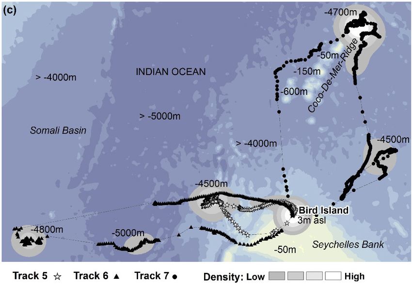
14                                              Neumann et al.: Sooty Terns on Bird Island, Seychelles

09h00. The track 4 bird departed just after 01h00 on 6 July, returning      above mean sea level in this part of the western Indian Ocean (see
at 15h00 on 7 July. The birds in tracks 5–7 spent proportionately less      Methods), this suggests that foraging Sooty Terns fly low over the
time on land after tagging (15%–24%; Table 1) and had no consistent         water, probably below 40 m, but we cannot be more precise. Of the
departure time. They did not return to Bird Island until the end of their   92 fixes above the reference ellipsoid, 33 involved records of two to
journey, suggesting that we caught them soon after their return.            four consecutive fixes, possibly representing sustained flights up to
                                                                            ca. 200 m above mean sea level.
The seven tracks involved 1 892 fixes. Most (94.8%) of the
altitudinal records were below the reference ellipsoid, with 97.1%          The birds provided with GPS tags had a wide range of change in
of them >20 m below it. With the reference ellipsoid being 20–60 m          body mass between tagging and recapture, from a loss of 48 g to a

Fig. 3. (a–d) Tracks obtained from incubating Sooty Terns overlaying the 8 d average SST for four periods between 18 June and 19 July
2014. Inset maps for (c) and (d) illustrate the relationship between high-density areas for tracks 5–7 and small pockets of cooler and variable
SST during the week of departure.

                                                      Marine Ornithology 46: 11–18 (2018)
Neumann et al.: Sooty Terns on Bird Island, Seychelles 15
gain of 23 g, with an average of 7.9 g lost. There was no significant foraging over the Seychelles Bank, inspection of SST maps (Fig. 4)
relationship between weight change and the duration of the interval shows that the bird with track 1 foraged southeast of Bird Island, close
between tagging and recapture (ANOVA F1 = 0.04, P = 0.84). to where SST was markedly cooler, in the week before departure
(26 June–3 July; Fig. 4b). For tracks 2–4, the greatest density of fixes
Foraging patterns was to the southwest, where SST ranged from 25.9 °C to 26.8 °C,
equaling the minimum and maximum SST values for 4–11 July
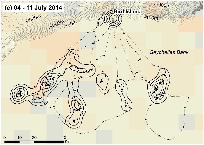
The Seychelles Bank appeared to offer at least three locally (Fig. 5). For birds departing after 10 July, tracks 5–7 also suggest that
important foraging areas between 4 and 7 July (Fig. 2b). birds travelled toward and foraged near areas with small pockets of
Birds did not fly the same routes, nor did they appear to feed cooler water and variable SST (see inset maps on Fig. 3).
concurrently at the same locations, suggesting multiple sites of
food abundance at this time. Track 4 was the first bird to depart Over the Seychelles Bank, chlorophyll concentrations were higher
the island for more than 24 h; the circuitous route taken displays in July than in June (Fig. 6), and in July a corridor of higher
a number of sites of higher-density fixes, suggesting that it took concentration extended from Seychelles to the west, along which
longer to procure food as availability decreased. Tagged birds birds 5 and 6 appear to have flown. Bird 7 tracked northwest toward
departing from 10 July onwards largely avoided the Seychelles the leading edge of a band of increased chlorophyll concentration in
Bank, opting to feed over deeper ocean waters (Fig. 2c). Upon the Indian Ocean (Fig. 6), but fed closer to the Coco-De-Mer Ridge,
departure, birds in tracks 5 and 6 initially passed over the where the concentration was lower.
western bank, where fixes from tracks 2 and 4 had indicated
foraging in previous days. However, density analysis reveals that Unpaired t-tests performed on daily 10 m wind component records
they did not stop here. The bird with track 7 flew directly to the (Dee et al. 2011) showed no significant change in wind speed
north side of the Coco-De-Mer Ridge, where it spent more than between the dates of departure and for the duration of each trip:
72 h over deep water (Fig. 2c). tracks 1–4 mean 6.82 m/s, standard deviation (SD) 2.56; tracks
5–7 mean 7.23 m/s, SD 2.57, t132 = 1.43, P > 0.1. Dominant wind
Between 18 June and 19 July, SST decreased over the Seychelles direction was consistent (southeast) during this period, and wind
Bank and in the wider ocean; this trend was not linear (Figs. 3–5). speed and direction were usual for the time of year in Seychelles
Cooling was most pronounced in the western ocean (Fig. 3). For birds (Windfinder 2017).
Fig. 4. Tracks obtained from incubating Sooty Terns foraging over the Seychelles Bank during food abundance (tracks 1–4), overlaying the
8–d average SST for four periods (a–d) between 18 June and 19 July 2014.
Marine Ornithology 46: 11–18 (2018)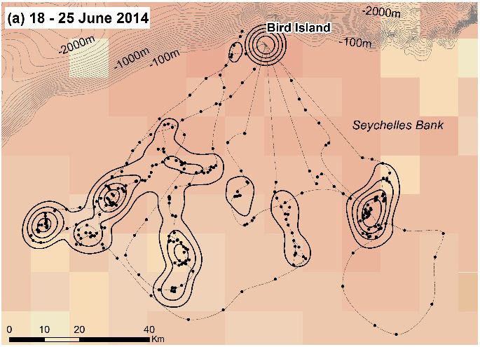
16                                          Neumann et al.: Sooty Terns on Bird Island, Seychelles

DISCUSSION                                                             When food was plentiful, departure of birds to the south in the
                                                                       mornings (readily visible from the island’s west coast) and arrival
Although we obtained GPS tracks from only seven foraging               from the south in the evenings were conspicuous features of Sooty
Sooty Terns in 2014, these tracks revealed an apparently abrupt        Tern behavior on Bird Island, as they have been most years since CJF
change in foraging behavior. This involved a switch from feeding       began studying them in 1972. During the food shortage, this southerly
within 100 km to the south of the Bird Island colony over the          commuting ceased; movements were less coordinated and were to the
shallow waters (10–150 m depth) of the Seychelles Bank, to             north and west. In 2008, northerly departures were also observed; in
much longer trips, in both time and distance, when they fed over       that year, 62 incubation shifts of ringed birds ranged from 1 d to 12
deeper water (4 500–5 000 m) of the western Indian Ocean, to           d, median 5 (CJF and Naomi Doak, unpubl. data), much longer than
the north and west of the breeding colony (Fig. 2). The longer         the 234 shifts that ranged from 1 d to 5 d, median 1, in 1973 (Feare
absences of incubating adults after the switch (Fig. 1) resulted in    1976). Departure and arrival directions on Bird Island might thus be
abandonment of eggs and recently hatched chicks, signifying that       indicative of periods of relative food abundance (over the Seychelles
the change in foraging behavior imposed a high cost on parental        Bank) or shortage and could be used as a quick assessment of feeding
care. These longer incubation shifts, together with the failure of     conditions each breeding season.
adults to regurgitate food when handled by us or disturbed during
intraspecific interactions within the colony, pointed strongly to a    We do not know whether the reduction in food availability was
food shortage beginning around 7 July and suggested that food          mediated through (1) a change in the abundance, behavior, or
availability over the Seychelles Bank had collapsed.                   distribution of potential prey that put them out of reach for surface-
                                                                       feeding Sooty Terns (Ashmole & Ashmole 1967, Schreiber et al.
At about the time of the switch, the SST index for the western         2002), or (2) a change in the distribution of predatory fishes that
tropical Indian Ocean fell sharply by ca. 0.8 °C, but recovered        drive smaller fish to the surface, only then making them available
within three weeks (The state of the ocean climate 2014). This is      to Sooty Terns (Au & Pitman 1986, Le Corre & Jaquemet 2005).
apparent in the SST records in Fig. 5, which indicated a decline
in SST on the Seychelles Bank but a decline with some recovery         The 2014 food shortage event that affected Sooty Terns was short-
over the wider western Indian Ocean. However, although Fig. 4          term and did not appear to have affected Brown Anous stolidus
confirms a general cooling of SST over the Seychelles Bank             or Lesser Noddies A. tenuirostris, both of which continued to
over the period of study, there is nothing in the finer-scale SST
records in Figs. 4 and 5 to account for a sudden collapse in food
supplies over the Seychelles Bank. The June and July chlorophyll
concentration distribution (Fig. 6) likewise gave no indication of
an anomaly on the Seychelles Bank during this period. However,
tracks 5 and 6 showed birds travelling over and feeding in areas of
higher chlorophyll to the west of Seychelles, while track 7 passed
through an area of higher chlorophyll concentration before feeding
to the north of the Coco-De-Mer sea mounts, where chlorophyll
concentrations were lower. The more distant journeys to the north
and west by birds in tracks 5 to 7 take them closer to the Somali
upwelling region, the surface outflow from which produces lower
SST and higher chlorophyll concentrations, spreading into the
northwest Indian Ocean (deCastro et al. 2016).

Fig. 5. Maximum (dashed line), minimum (dotted line), and mode         Fig. 6. Tracks obtained from incubating Sooty Terns overlaying
(solid line) 8 d SST recorded over four weeks. Black lines represent   the monthly average chlorophyll concentration for (a) June 2014
SST values from the Seychelles Bank (in vicinity of tracks 1–4).       and (b) July 2014. Missing data (9% for June and 7% for July 2014
Grey lines represent SST values from the wider ocean (in vicinity      datasets) were calculated using an average for that month from the
of tracks 5–7).                                                        previous five years.

                                                   Marine Ornithology 46: 11–18 (2018)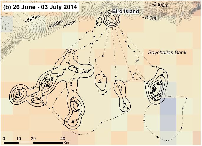
Neumann et al.: Sooty Terns on Bird Island, Seychelles                                         17

regurgitate food when handled for another investigation (C.              ACKNOWLEDGEMENTS
Lebarbenchon, pers. comm. and CJF & CSL, pers. obs.) during
the Sooty Tern food shortage. During the 1973 breeding season            This work was made possible by the generous financial support of
on Bird Island, Feare (1976) recorded two brief periods of weight        the British High Commission (Seychelles, though Commissioner
loss of large chicks, which he attributed to food shortage, and          Lindsay Skoll), James Cadbury, the Percy Sladen Memorial Fund
also recorded periodic sharp changes in the species and size             and U3A Haslemere, UK. Excellent logistical support was provided
of prey being brought to the chicks, suggesting that brief food          by the owners of Bird Island, Guy and Marie France Savy, in the
shortages are not exceptional. Catry et al. (2013) documented            planning and practical phases of the project. We are also grateful
two kinds of food shortage experienced by the seabird community          to Camille Lebarbenchon and Muriel Dietrich for assistance in the
in Seychelles: (1) short-term events affecting just a few seabird        field and discussion, and to two anonymous reviewers and the editor
species, for which the cause was unclear, and (2) longer-term            for helpful suggestions. Gary Brodin is a Director of PathTrack Ltd.
events affecting all species, related to large-scale events such as
El Niño–Southern Oscillation and swings in the Indian Ocean              REFERENCES
Dipole. The food shortage that was associated with tracks 5–7 in
this study was an example of former.                                     ASHMOLE, N.P. 1963. The breeding of the Wideawake or Sooty
                                                                           Tern Sterna fuscata on Ascension Island. Ibis 103b: 297-364.
Due to the uncertainties inherent in the altitude records, we            ASHMOLE, N.P. & ASHMOLE, M. J. 1967. Comparative feeding
cannot determine precisely how high Sooty Terns fly above the              ecology of seabirds of a tropical oceanic island. Bulletin of the
sea surface during their foraging flights. Our data suggest that           Peabody Museum of Natural History 24: 1-131.
they generally fly low, probably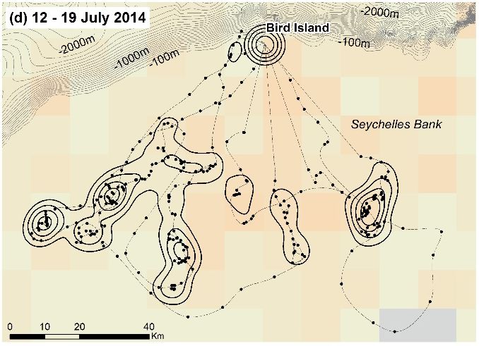
18                                           Neumann et al.: Sooty Terns on Bird Island, Seychelles

GENERAL BATHYMETRIC CHART OF THE OCEANS                                 NATIONAL CENTRE FOR ANTARCTIC AND OCEAN
   (GEBCO). 2014. The GEBCO_2014 Grid, version 20150318.                   RESEARCH (NCAOR). 2015. Indian Ocean geoid low.
   [Available online at: www.gebco.net. Accessed 11 April 2017].           [Available online at: http://www.ncaor.gov.in/pages/
HARRINGTON, B.A. 1974.Colony visitation behavior and breeding              researchview/11. Accessed 27 October 2015].
   ages of Sooty Terns (Sterna fuscata). Bird Banding 45: 115-144.      PITCHER, T.J., MORATO, T., HART, P.J.B., CLARK, M.R.,
HUGHES, B.J. 2014. Breeding and population ecology of Sooty                HAGGAN, N., & SANTOS, R.S. 2007. The depths of ignorance:
   Terns on Ascension Island. PhD thesis. Birmingham, UK:                  An ecosystem evaluation framework for seamount ecology,
   University of Birmingham.                                               fisheries and conservation. In: PITCHER, T.J., MORATO, T.P.,
JAEGER, A., FEARE, C.J., SUMMERS, R.W., LEBARBENCHON,                      HART, J.B., CLARK, M.R., HAGGAN, N. & SANTOS, R.S.
   C., LAROSE, C.S. & LE CORRE, M. 2017. Geolocation reveals               (Eds.) Seamounts: Ecology, Fisheries, and Conservation. Fish
   year-round distribution of a superabundant tropical seabird,            and Aquatic Resources Series 12. Oxford, UK: Blackwell.
   the Sooty Tern Onychoprion fuscatus. Frontiers in Marine             RICHARDSON, P.L. 2015. Upwind dynamic soaring of albatrosses
   Science doi: 10.3389/fmars.2017.00394.                                  and unmanned UAVs. Progress in Oceanography 130: 146-156.
JAQUEMET, S., LE CORRE, M. & QUARTLY, G.D. 2007. Ocean                  SCHREIBER, E.A., FEARE, C.J., HARRINGTON, B., MURRAY,
   control of the breeding regime of the sooty tern in the south-west      B., ROBERTSON, W.B., ROBERTSON, B. & WOOLFENDEN,
   Indian Ocean. Deep Sea Research 54: 130-142.                            G.E. 2002. Sooty Tern Sterna fuscata. In: Poole, A. & Gill, F.
JAQUEMET, S., POTIER, M., CHEREL, Y., ET AL. 2008.                         (Eds.) The Birds of North America, No. 665. Philadelphia, PA:
   Comparative foraging ecology and ecological niche of a                  The Birds of North America, Inc.
   superabundant tropical seabird: the sooty tern Sterna fuscata in     SINGH, A. & AUNG, T. 2005. Effect of barometric pressure on sea
   the western Indian Ocean. Marine Biology 155: 505-520.                  level variations in the Pacific region. South Pacific Journal of
LE CORRE, M. & JAQUEMET, S. 2005. Assessment of the seabird                Natural Science 23: 9-15.
   community of the Mozambique Channel and its potential use            SOANES, L.M., BRIGHT, J.A., BRODIN, G., MUKHIDA, F. &
   as an indicator of tuna abundance. Estuarine, Coastal and Shelf         GREEN, J.A. 2015. Tracking a small seabird: First records of
   Science 63: 421-428.                                                    foraging movements in the Sooty Tern Onychoprion fuscatus.
MORITZ, H. 2011. A contemporary perspective of geoid structure.            Marine Ornithology 43: 235-239.
   Journal of Geodetic Science 1: 82-87.                                The state of the ocean climate [online]. Ocean Observations Panel
NASA EARTH OBSERVATIONS (NEO). 2017a. Sea Surface                          for Climate. [Available online at: http://stateoftheocean.osmc.
   Temperature 8-Day AQUA-MODIS. [Available online at: https://            noaa.gov/sur/ind/wtio.php. Accessed 1 August 2014].
   neo.sci.gsfc.nasa.gov/. Accessed 10 May 2017].                       Windfinder [Online]. 2017. Wind and weather statistics Mahé/
NASA EARTH OBSERVATIONS (NEO). 2017b. Chlorophyll                          Seychelles Airport. [Available online at: https://www.windfinder.
   Concentration 8-Day AQUA-MODIS. [Available online at:                   com/windstatistics/mahe_seychelles_airport. Accessed 15
   https://neo.sci.gsfc.nasa.gov/. Accessed 10 May 2017].                  September 2017].

                                                   Marine Ornithology 46: 11–18 (2018)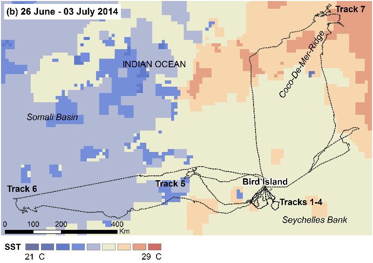
You can also read