Pca postclassicalarchaeologies - european journal of - European Journal of Post-Classical Archaeologies
←
→
Page content transcription
If your browser does not render page correctly, please read the page content below

pca                   european journal of
             postclassicalarchaeologies

                volume 9/2019

SAP Società Archeologica s.r.l.

       Mantova 2019
pca
EDITORS                                                              EDITORIAL BOARD
Gian Pietro Brogiolo (chief editor)                                  Paul Arthur (Università del Salento)

Alexandra Chavarría (executive editor)                               Margarita Díaz-Andreu (ICREA - Universitat de Barcelona)
                                                                     José M. Martín Civantos (Universidad de Granada)
ADVISORY BOARD                                                       Girolamo Fiorentino (Università del Salento)
Martin Carver (University of York)                                   Caterina Giostra (Università Cattolica del Sacro Cuore di Milano)
Matthew H. Johnson (Northwestern University of Chicago)              Susanne Hakenbeck (University of Cambridge)
Giuliano Volpe (Università degli Studi di Foggia)                    Vasco La Salvia (Università degli Studi G. D’Annunzio di Chieti e Pescara)
Marco Valenti (Università degli Studi di Siena)                      Bastien Lefebvre (Université Toulouse - Jean Jaurès)
                                                                     Alberto León (Universidad de Córdoba)
ASSISTANT EDITOR                                                     Tamara Lewit (Trinity College - University of Melbourne)
                                                                     Federico Marazzi (Università degli Studi Suor Orsola Benincasa di Napoli)
Francesca Benetti
                                                                     Dieter Quast (Römisch-Germanisches Zentralmuseum Mainz)
LANGUAGE EDITOR                                                      Andrew Reynolds (University College London)
                                                                     Mauro Rottoli (Laboratorio di archeobiologia dei Musei Civici di Como)
Rebecca Devlin (University of Louisville)
                                                                     Colin Rynne (University College Cork)

Post-Classical Archaeologies (PCA) is an independent, international, peer-reviewed journal devoted to the communication of
post-classical research. PCA publishes a variety of manuscript types, including original research, discussions and review ar-
ticles. Topics of interest include all subjects that relate to the science and practice of archaeology, particularly multidiscipli-
nary research which use specialist methodologies, such as zooarchaeology, paleobotany, archaeometallurgy, archaeome-
try, spatial analysis, as well as other experimental methodologies applied to the archaeology of post-classical Europe.
Submission of a manuscript implies that the work has not been published before, that it is not under consideration for
publication elsewhere and that it has been approved by all co-authors. Each author must clear reproduction rights for
any photos or illustration, credited to a third party that he wishes to use (including content found on the Internet). For
more information about ethics (including plagiarism), copyright practices and guidelines please visit the web site
www.postclassical.it.
PCA is published once a year in May, starting in 2011. Manuscripts should be submitted to editor@postclassical.it in
accordance to the guidelines for contributors in the webpage http://www.postclassical.it
Post-Classical Archaeologies’s manuscript review process is rigorous and is intended to identify the strengths and weak-
nesses in each submitted manuscript, to determine which manuscripts are suitable for publication, and to work with the
authors to improve their manuscript prior to publication.
This journal has the option to publish in open access. For information please visit the web site www.postclassical.it
How to quote: please use “PCA” as abbreviation and “European Journal of Post-Classical Archaeologies” as full title.
Cover image: statue of Mont’e Prama (from F. Pinna with modifications).
“Post-Classical Archaeologies” is indexed in Scopus. It was approved on 2015-05-13 according to ERIH PLUS criteria for
inclusion and indexed in Carhus+2018. Classified A by ANVUR (Agenzia Nazionale di Valutazione del sistema Universi-
tario e della Ricerca).
DESIGN
Paolo Vedovetto
PUBLISHER
SAP Società Archeologica s.r.l.
Strada Fienili 39/a, 46020 Quingentole, Mantova
www.archeologica.it

Authorised by Mantua court no. 4/2011 of April 8, 2011
For subscription and all other information visit the web site www.postclassical.it

ISSN 2039-7895
pca              european journal of
                                              postclassicalarchaeologies
                                                                volume 9/2019

                                                        CONTENTS PAGES

EDITORIAL                                                                5

RESEARCH - PARTICIPATORY RESEARCH IN ARCHAEOLOGY.
LEGAL ISSUES AND GOOD PRACTICES
A. Olivier    Socialising heritage: polity and praxis                    9
G. Tully      Skills, ethics and approaches: an introduction to ‘the     35
              basics’ of participatory archaeology
A. Castillo Mena Participative processes in cultural heritage manage-    61
               ment. Methodology and critical results based on expe-
               riences within the Spanish World Heritage context
B. Wilkins    A theory of change and evaluative framework for            77
              measuring the social impact of public participation in
              archaeology
G.P. Brogiolo, A. Chavarría Arnau Archaeology for local communities      101
               in Northern Italy: experiences of participatory rese-
               arch in an adverse legal framework
F. Pinna      Archeologia e costruzione partecipata dell’identità lo-    123
              cale: percorsi di archeologia di comunità in Sardegna
S. Thomas     Doing public participatory archaeology with “difficult”    147
              conflict heritage: experiences from Finnish Lapland
              and the Scottish Highlands
F. Benetti, C.P. Santacroce In the public interest? Archaeological       169
              research, permits and public participation in Italy
K. Möller     Will they or won‘t they? German heritage laws, public      199
              participation and the Faro Convention
R. Karl       Authorities and subjects? The legal framework for          219
              public participation in Austrian archaeology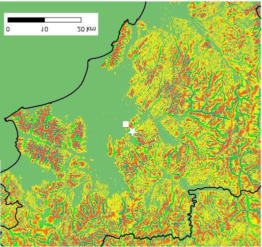
M. Rizner        Participatory research in archaeology in Croatia:                  257
                 between law and practice
L. Delgado Anés, J.M. Martín Civantos The legal framework of                        269
            cultural landscapes in Andalusia (Spain): limits and
            possibilities of public participation from an archaeolog-
            ical perspective
K.A. Pyburn      Archaeology by, for, and about the public                          291

BEYOND THE THEME
E. Zanini        Trama e ordito di un territorio: un esperimento tra                303
                 (micro) Big History e archeologia pubblica a Vignale di
                 Maremma (Toscana)
C. Citter        From roads to mobility. A theoretical framework and a              325
                 case study to investigate the medieval connections net-
                 work
F. Sogliani, D. Roubis The discovery of the monastic settlement of                  343
               Jure Vetere (S. Giovanni in Fiore, Calabria, Italy): a
               multidisciplinary project of landscape archaeology

RETROSPECT
T. O’Keeffe      The archaeology of Ireland’s long middle ages: retro-              365
                 spective and prospective

PROJECT
L. Band          CITiZAN 2015-2018 and 2019-2021, a community                       399
                 archaeology project past and future: successes, chal-
                 lenges, potential solutions

REVIEWS                                                                             411
S. Rippon, Kingdom, Civitas, and County. The Evolution of Territorial Identity in
       the English Landscape - by G.P. Brogiolo
W. Scheidel, The Science of Roman History: Biology, Climate, and the Future of
      the Past - by M. Fecchio
A. Izdebski, M. Mulryan, Environment and Society in the Long Late Antiquity - by
        M. Rottoli
M. Marinato, Alimentazione, salute e mobilità della popolazione in Italia setten-
      trionale tra IV e VIII secolo. Approcci bioarcheologici - by P.M. De Marchi
V. Amorós Ruiz, El Tolmo de Minateda en la Alta Edad Media. Cerámica y Con-
      texto - by J. Sarabia
B. Lefebvre, La formation d’un tissu urbain à Tours. De l’amphithéâtre antique au
        quartier canonial - by M.-A. Causarano
A. Chavarría Arnau, M.-A. Causarano (eds), La memoria culturale dell’Oltresarca
       trentino. Paesaggi, persone e storie di pietre - by V. Higgins

                                                PCA volume 9/2019 ISSN: 2039-7895
                                                Post-Classical Archaeologies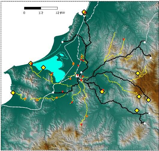
PCA 9 (2019) ISSN: 2039-7895 (pp. 5-8)
Post - Classical Archaeologies

EDITORIAL

    In this ninth volume of the European Journal of Post-Classical
     Archaeologies we publish the contributions of the Spring School held
in Tenno (Trentino, Italy) in April 2018, which was devoted to the meth-
ods of “Participatory Research in Archaeology. Archaeology for the fu-
ture? Legal issues and good practices”. The event was generoulsy fund-
ed by the University of Padova (call Winter-Summerschool 2017) and
broght together researchers and PhD students interested in discussing
the legal framework and constraints that this kind of participatory ap-
proach involves and how good practice in community projects could rep-
resent a turning point for the immediate future of archaeology. Partici-
patory Archaeology has a similar meaning to “Community Archaeology”
and both are included in the wider label of “Public Archaeology”, although
the terms are not at all synonymous. Community and Participatory Ar-
chaeology should not be confused with communication or education
strategies, although these are also of great importance, but it takes col-
laboration between “professionals” and “the public” or the “audience” to
a very different level. Community or Participatory Archaeology follows
the now popular formulation by Gabriel Moshenska of “archaeologists
working with the public” (Moshenska 2017, p. 6; reflected in this volume
by Suzie Thomas at p. 149), but we would add an extra dimension in the
form of a final objective of “working also for the public”.
    An important question emerges here: what public? Does this refer to
“non-professional (in the sense of archaeology) groups and individuals”
who intend to be involved in research “with the goal of finding out more
about archaeological heritage through participatory practices” (as sug-
gested by Thomas)? Or should we include under this label the indifferent
and those who reject the past and its heritage? This inevitably leads us
to reflect on the various meanings today of communities and on which
“participatory practices” are appropriate for their involvement.

                                                                        5
These problems, in turn, lead us to reflect on the cultural policy guide-
lines proposed, after Second World War, by institutions on the world
(UNESCO, International Union for Conservation of Nature (IUCN), World
Bank), European (Council of Europe, European Union) and national (be-
tween principles included in the Constitutions or issued with specific
acts) level. Guidelines, summarized in the contributions of Adrian Olivier
and Lara Delgado Anés with José María Martín Civantos, reveal contra-
dictory or incomplete ideas. This is not only because they have different
aims – “the management of landscapes and uses of land are represented
by a combination of different demands and interests linked to agriculture,
forestry, livestock, conservation of nature, conservation of cultural her-
itage, archaeology and local populations” (Delgado Anés, Martín Civan-
tos) – but also because they fluctuate between proposed identities
(local, national or European), legislation linked to professionalism and pro-
tection from above (see the Valletta Convention) and openness to public
participation (Conventions of Florence and Faro). These contradictions
are reflected in the great variability of national and/or regional norms re-
garding the possibility of public participation in Cultural Heritage in Eu-
rope (discussed in the contributions of Francesca Benetti, Clemente Pio
Santacroce for Italy, Katharina Möller for Germany, Raimund Karl for
Austria, Mia Rizner for Croatia, Lara Delgado Anés, José María Martín
Civantos for Andalusia in Spain). This ranges from the harshest exclusion
(in Italy and Austria) to various modes of involvement, more or less open,
that confirm that Europe is today a sum of states, each of which is at-
tentive to its particular interests, even though they superficially refer to
the search for a common heritage identity. Research into historical iden-
tities, pursued in the past, does not fall within the objectives of commu-
nity archaeology, which highlights the multiplicity of stories that can be
drawn from the infinite information we can document in a region.
    Most of the contributions focus on the variegated “participatory prac-
tices” adopted in concrete projects, noting limits, methods, successes
and difficulties. Projects above all try to involve public participation in all
stages of the project: starting from the planning stage, continuing with
real research and concluding in publication and management of the re-
sults. Different positions are, however, taken by the authors on who has
or should coordinate and lead the projects so as to achieve the difficult
equilibrium between bottom up and top down approaches. The result
often does not reflect the “ordinary perception and needs of the commu-
nities” (Alicia Castillo Mena), which can emerge only through reflection
and comparison: people need the past ... but not “our concept” (academ-
ic) of the past and the value that we as academics attribute to it”. Most
papers consider the possibility of assessing the impact or results of the

6
projects in the territories involved, a subject to which most discussions
were devoted during our week in Tenno. The importance of the subject
led us to contact Brendon Wilkins to delve more deeply into the problem
of evaluation. Best practice and the actual degree of satisfaction and
success of a project can be assessed in relation to the effects on “ar-
chaeology and heritage, individuals, community/society” (a gradation in
three levels). However, this judgment cannot be reserved for experts,
but must be extended to the various components of local communities.
The social impact assessment is also linked to the collection of re-
sources, through crowd-funding and crowd sourcing, discussed by Wilkins
using the example of the Bronze Age site excavation at Flag Fen, near
Peterborough (UK).
    The actual role assigned to the communities finally leads us to reflect
on the themes, strategies and aims of the projects. Lara Band, in the
Project section, offers us a good example with the well-known project CIT-
iZAN, which from 2015-2018 involved 1000 people in the recording of
coastal and intertidal sites in England which were threated by climate
change. This project, which had a notable social and media impact, was
re-proposed for 2019-2021, including, in addition to recording, multiple
collateral initiatives (training sessions, public presentations, websites and
media activation) as are typical of participatory archaeological projects.
    A systemic approach that proposes a reunification of knowledge of-
fers a scientific justification for the “holistic” protection of heritage, and
suggests an archaeology of sustainability in the context of possible eco-
nomic and social uses of results, has been tested in a dozen projects in
northern Italy (Gian Pietro Brogiolo, Alexandra Chavarría Arnau). Con-
crete objectives are able to avoid the construction of political identities,
such as that described by Fabio Pinna for Sardinia, where archaeology
is well-funded by the region with the political objective of creating an
identity linked to the Nuragic civilization of the Iron Age.
    It is also undeniable that community projects very often drag archae-
ologists in complex social and political environments or ethical issues
linked to the kind of conflictual heritage which is involved in the project
(as in Thomas’ paper). Participatory projects take specialists out of the
ivory tower that academia represents into a wider, in some cases un-
known world, and, in the same way as stratigraphic excavation or GIS
managements require specific innate qualities of the archaeologist, par-
ticipatory research also requires particular skills such as being “open,
friendly and effective communicators, adaptable, good listeners, able to
accept varied opinions, efficient record keepers and evaluators, team
workers” (Gemma Tully).

                                                                          7
The concluding paper by K. Anne Pyburn, and which is more than a
conclusion, summarizes and discusses the topics addressed in the sem-
inar, ordering them into eight key subjects or themes: Experts versus ex-
pertise, Agents versus agency, Discovery versus interpretation, Democ-
racy versus sovereignty, Public versus community, Education versus col-
laboration, Legal versus ethical, Protection versus appropriation.
The three papers of the Beyond the Theme sections are linked, in a
different way, to research perspectives on past local communities. Enri-
co Zanini, in relation to the research conducted in Vignale (Grosseto),
hopes for a “form of dialogue with the landscape” that recomposes the
“wear”, produced by excavation, through diachronic routes able to con-
nect activities that are repeated over time: the “warp”, understood as
anthropic activity (the road, the furnaces, the vineyards), compared to
the “landscape weft”, dictated by the earth and water. Carlo Citter com-
pares road networks documented in the cadastral maps of 1823 and
predictive analyses using GIS (in particular cost surfaces and attrac-
tors), emphasizing continuity, starting from the Bronze Age, of the net-
work of local connections through which peasants, merchants and own-
ers moved in relation to a central place (and also, it should be added, in
relation to places and resources). Francesca Sogliani and Dimitris
Roubis present a systemic and multidisciplinary research model applied
to the settlement at San Giovanni in Fiore, Calabria, including written
sources, ethnoarchaeological data, photo-interpretations, geological and
geopedological research based on excavations, surveys, remote sensing,
geophysical surveys, pollen and botanic analysis.
Finally, in the Retrospect section dedicated this time to Ireland,
Tadhg O’Keeffe not only draws the history of medieval archaeology in
that country, but also addresses some issues: “identity and cultural es-
sentialism, the concept of continuity and change, the relationship of pat-
tern to process, the meanings of words”, that emerge above all in the
relationship between the native, “Gaelic-Irish” population with respect to
the “colonial” castle-owning Anglo-Norman class.
8beyond
the theme
Carlo Citter*
From roads to mobility.
A theoretical framework
and a case study to investigate
the medieval connections network
This paper briefly reviews the main methods to study historical mobility over time. Then, it
focuses on a region in southern Tuscany to run a network analysis. We wish to evaluate the
potential connections from a central place to its surrounding hinterland between the Late
Antiquity and the Early Middle Ages and to estimate the longue durée of some geographical
corridors. Some corridors have been used at least since the Etruscan period (7th century
BC). The Romans shaped a series of paths within these corridors to connect fiscal estates’
centres, such as those owned by the emperor for his institutional role (2nd century AD).
This network was resilient to political and climate changes in the Middle Ages and beyond.
Keywords: historical mobility, GIS, spatial analyses, long durée
Questo articolo presenta i metodi di studio della mobilità antica e si focalizza poi su una
regione nella Toscana meridionale per condurre una network analysis. Lo scopo è quello di
valutare le potenziali connessioni da un central place al suo territorio tra il tardo antico e
l’alto medioevo, stimando la longue durée di alcuni corridoi geografici. Alcuni di essi sono
stati in uso almeno dal periodo etrusco (VII sec. a.C.). I Romani hanno poi dato forma a una
serie di percorsi all’interno di questi corridoi per connettere proprietà fiscali, come quelle
possedute dall’imperatore per il suo ruolo istituzionale (II sec. d.C.). Questa rete fu resiliente
a cambiamenti politici e climatici avvenuti nel medioevo e oltre.
Parole chiave: mobilità storica, GIS, analisi spaziali, diacronia
1. Current approaches on historical roads and mobility1
1.1. Roads and routes
Medieval archaeologists are usually less interested in routes than in
settlements, though in the last decades things changed a little all around
Europe2. Topographers are very active, especially in the Mediterranean.
They promote studies on Roman and medieval roads, according to traces
within historical maps and aerial photos and to material remains. This ap-
* University of Siena, Department of Hitorical Sciences and Cultural Heritage, Siena, Italy, carlo.
citter@unisi.it.
1 I wish to thank Susan Oosthuizen who kindly read and commented this text and helped me in word-
ing.
2 Innovative approaches in the last decade are FáBREGA áLVAREZ, PARCERO OUBIñA 2007; HERZOG
2013; VERHAGEN 2013; VAN LANEN et al. 2015.
PCA 9 (2019) ISSN: 2039-7895 (pp. 325-342) Post - Classical Archaeologies
Received: 11-11-2018 - Accepted: 06-01-2019 - Revised: 30-01-2019 325Carlo Citter
proach is robust, because it produces a consistent amount of data to
support the reconstruction of a road3. On the other hand, it often focus-
es on connecting A to B, and on major roads. Sometimes, it also pre-
sumes that a central authority projected any given road. The step for-
ward is to consider a route, rather than a single road. It still connects
A to B, but its path varies over time, due to climate changes, political
events, and so on. The via Francigena or Romea, the route connecting
England to Rome via France, is a typical case study (Stopani 1998). In
fact it is not a Roman major road: pilgrims started shaping its path at
least since the 7th century AD. Actually, there is a robust literature on
Roman roads that takes this into account too4. Thus, researchers have
now accepted a less rigid idea of connectivity.
In the last three decades, there have been two new developments in
this field of research: new theoretical approaches and computer applica-
tions. The first one is a series of new approaches to landscape studies
that opened new questions. The economic aspect is of course relevant,
but it is not the only one. Routes within a historical landscape can shape
a hierarchy of central places and land-ownership and contribute to main-
tain the relationships among different communities5. They can also relate
to belief, being part of wider symbolic paths (Semple 2008).
The rapid development of the digital humanities produced several at-
tempts to shape a route with a GIS-based simulation6. The latter had less
impact on literature, being often considered a deterministic approach. In
fact, it presumes that humans always opted for the least cost path, which
is proved to be not completely true. Things change radically, if we turn
from predict to postdict, i.e. to analyse, which factors influenced a path
we have reconstructed. A GIS-based simulation is thus helpful to evaluate
the changing impact of both human and natural factors over time7.
1.2. Mobility and the longue durée
Current advanced approaches shift the focus from a single route to
potential mobility in a given geographical context. The concept of mobility
is wider than that of route. Settlements can be connected one another
3 It also allows to stress the role of the road as generator and/or attractor of settlements and ser-
vice to people on the move - see CORSI 2000.
4 The idea that even the main roads were a bundle more than a single path is already in CHEVALLIER
1972 and RADKE 1981.
5 See for instance OOSTHUIZEN 2017 on the fragile environment of the Fenland.
6They are grouped under the label “least cost path” and produced an abundant literature. See POLLA,
VERHAGEN 2014. The best overview of a GIS approach is HERZOG 2013.
7 A critical evaluation of pros and cons in CITTER, PATACCHINI 2018.
326From roads to mobility...
with or without a road. Thus, a study of potential connections unveils a
complex network linking all the settlements, not only the main ones. In ad-
dition, it makes possible to connect distant regions through the sum of
local mobility networks. This new approach, promoted mainly by French
archaeogeographers8, changes the way we study the mobility over time.
In fact, it reduces the impact of top-down projects, while stressing the
bottom-up making of local, regional and long-distance connections.
Following this approach, we can define most of major roads recorded
in the historical maps as the transformission of existing paths9. Thus,
these routes are the sum of thousands of segments of local pre-existing
mobility and the longue durée is the only possible time span. Correctly,
archaeogeographers remark the role of resilience of old paths over time.
Something similar raised from the side of GIS-based approach too.
The concept of natural corridors, where the mobility is naturally easier
is quite well developed10.
2. From roads to mobility: a case study
2.1. Introducing the selected area: the geographical settings (fig. 1)
The selected area is a small portion of western central Italy. The lat-
ter is delimited by the Tyrrhenian sea to the west, by the Apennines to
the north and east and by the river Tiber to the east and south. Within
this large area of about 40,000 square km we selected a small portion
to run an analysis of the mobility network between AD 400 and 900: the
territory of Rusellae near Grosseto.
We chose it because we made several excavations11, geophysics
(Campana 2018), surveys (Citter 2011; Vaccaro et al. 2013), and a
complete scrutiny of all the published written sources, that includes his-
torical place-names (Chirico, Citter 2018). This area has a good digital
map service, that includes the georeferenced historical 1823 cadastre,
though it is still not fully covered by free on-line LIDAR survey. For this
study we used a 10 m cellsize DTM (Tarquini et al. 2007 and 2012).
8 An overview of the discipline’s theoretical framework is CHOUQUER, WATTEAUx 2013.
9 This word comes out of transformation + transmission and it explains the concept of an ever chang-
ing feature - see CHOUQUER 2007, pp. 181-183.
10 See among the others WHITLEY, HICKS 2003, though it is not focused on Medieval Europe.
11 The town of Grosseto (CITTER 2007), the town of Rusellae (CATALDI, DE BENETTI 2013), the hilltop
site of Poggio Cavolo (VACCARO et al. 2008) the Roman temple of Diana Umbronensis (SEBASTIANI et
al. 2015). Further notes on the medieval sites of La Canonica and Moscona are in NICOSIA, POGGESI
1998.
327Carlo Citter
Fig. 1. The selected area within Italy. Main geographical features are emphasised.
The area consists of alluvial plains of different extension, and moun-
tains. The highest one, Monte Amiata, reaches 1,700 m. while most of
the land falls into a low- to mid-hill category, i.e. up to 400 m asl. The
main river (fiume Ombrone) flows from north-east to south-west and it
has several smaller tributaries that flow mainly within narrow valleys.
The coast used to be a lagoon to extract sea salt and for fish-ponds until
the end of the Middle Ages and even later. The main resources have al-
ways been pasture and woods, with a considerable portion of coastal
areas cultivated for crops. Since the Late Middle Ages, marshes became
the main problem for this region, due to health diseases and one of the
main causes of depopulation12.
2.2. Introducing the selected area: framing history and settlement
patterns AD 400-900
Rusellae is an Etruscan town and, later, a Roman municipium. We
don’t know when they appointed a bishop there, but he is first mentioned
in AD 499. During the 6th century Rusellae was a Byzantine stronghold
12 Marshes and diseases could have been present even before, but their impact is still under scrutiny
- p.c. Mariagrazia Celuzza who is studying the medieval cemetery of Rusellae.
328From roads to mobility...
while the Lombards possibly appointed a gastaldus there, since a district
is mentioned in the sources (Citter 2007, p. 452).
Major towns and great harbours remained active in northern Tuscany
between AD 400 and 600, while in southern Tuscany, where Rusellae is
positioned, the network collapsed (Cantini, Citter 2010). However, they
did not vanish as recent studies point out. Extensive and long lasting sur-
veys produced a reliable base information about the settlement pattern
(Citter 2011; Vaccaro 2011; Campana 2018). Sparse minor settle-
ments did not vanished, but their impact on the landscape had already
dropped down by AD 300. Large villas flourished until ca. AD 500, while
a handful of them survived between AD 550 and 600. Most of the area
falls within large imperial estates of the res privata or res caesaris,
whose transmission to the royal goods in the Early Middle Ages is proved
to be surprisingly matching (Chirico, Citter 2018). They persisted in the
Middle Ages until the Communal towns promoted a new phase of devel-
oping trades after AD 1100 (Vallelonga et al. 2018). Grosseto devel-
oped from a small to a large village between AD 700-800, when at least
two churches are witnessed, and expanded up to AD 1300.
2.3. Moving all around and creating networks over time
In this paper we wish to start from a network analysis and go fur-
ther13. We wish to study the potential connection from a central place
to its surrounding hinterland. Then, we wish to evaluate the main routes’
resilience over time by comparing the result with the first precise picture
of this area: the 1823 historical cadastre.
Network analyses base the evaluation on a cost surface, which is it-
self an estimation. The researcher should make it according to environ-
mental and human factors that influence mobility14.
In this case study we used the TPI landform classification algorithm
to evaluate the morphology of the selected area15 (fig. 2-a). In a few
words, it classifies each cell of the raster map by analysing its surround-
ings at two different radii (in this case 100 m and 1000 m). Thus, a cell
at 100 m asl could be a height in a plain and a valley bottom in a moun-
tain. Slope is evaluated in the same way within this algorithm. The re-
turned map is the most accurate description of a landscape from the
morphological point of view.
13 We used QGis 2.18 and SAGA 2.3.
14See HERZOG 2013 and 2014 with detailed analyses of the base map and of the factors to consider.
The procedure we use in this case study can be ascribed to the main category of central point net-
works mentioned in HERZOG 2013, pp. 10-12.
15 Topographical Positioning Index. Details about the algorithm in WEISS 2001 and SEIF 2014.
329Carlo Citter
A
B
Fig. 2. The TPI (a) and TWI (b).
330From roads to mobility...
The TPI raster map has been reclassified according to the possibility
for a man to move within its cells. The output is a simplified raster map,
whose cells have 6 values within a range from 0 to 10016. We repeated
the procedure with the TWI algorithm17 (fig. 2-b). It evaluates the slope
in a given point and the potential humidity catchment area flowing into
that point. We summed the two reclassified rasters within the raster
calculator18 (fig. 3-a). The output is our cost surface, i.e. the base to run
a further algorithm that calculates the possibility to move from a given
point in any direction, according to that specific cost surface19 (fig. 3-b).
Of course, the cost surface can incorporate other factors like market-
places, towns, harbours and so on. We focused on geographical ones to
wonder, whether there could be major channels of movement within this
territory, no matter the period we are studying.
The last step is to simulate a stream network originating from a cen-
tre. We chose the site of Terme Rosellane, a large series of 1st to 3rd
century AD richly refurbished buildings 2.5 km SW of the political centre,
the town of Rusellae, and we generated a stream network from it. It is
likely that it used to be the main fiscal and judicial centre of the selected
area. The streams represent the potential connections between the cen-
tre and the territory in any direction, according to that cost surface20.
The returned map shows a network of polylines that amazingly allow
Terme Rosellane to connect with all the other fiscal estates’ centres
16 They are related to the difficulty of walk through the cost surface, where 0 means no difficulty at
all, while 100 means almost impossible to walk through. The original TPI landforms classification re-
turns 10 classes. In this case we opted to reclassify as follows: canyons, deeply incised streams as
50, midslope drainages, shallow valleys as 20, upland drainages, headwaters as 30, U-shape valleys
as 20, plains as 10, open slopes as 0, upper slopes, mesas as 30, local ridges/hills in valleys as 20,
midslope ridges, small hills in plains as 20, mountain tops, high ridges as 10. We assume that to walk
through an open slope is usually easier than anywhere else. Plains could be easy, but they have no
slope at all and this could mean stagnation especially during the colder and wetter so called Late An-
tique Little Ice Age. Upper slopes and local ridges can be difficult to reach. Of course, other classifi-
cations are possible. See also the notes at 3.3 about who is moving within this landscape. We assume
a single person without heavy baggage.
17 Topographical Wetness Index. For details see SøRENSEN et al. 2006, PEI et al. 2010. For a use in
archaeology see BROGIOLO, CITTER 2018. We reclassified as follows: 2 to 7 = 0, 7 to 10 = 10, 10 to
15 = 20 and 15 to 20 = 70. The last class stresses the cells overlaying the ancient reclaimed lagoon
by considering them as an obstacle.
18 The raster calculator is a simple procedure. The researcher overlays two or more raster maps and
runs the calculation (in this case a sum) of corresponding cells. For instance: a cell, whose value is
10, overlays a cell, whose value is 5. The sum in the raster calculator returns a cell, whose value is
15. The procedure is repeated for all the cells. We ascribed a value of 60% to the TPI and of 40%
to the TWI. Thus the formula is TPI_reclassified * 0.6 + TWI_reclassified * 0.4. This allow, for in-
stance, to let the algorithm feel the presence of the coastal lagoon west of Grosseto.
19 This algorithm is called r.walk and it is incorporated within QGis as one of the GRASS tools. It sim-
ulates the difficulty to move all around a given point by sensing the cost surface as a friction layer.
20 We run the algorithm “channels network and drainage basins” from SAGA with a threshold of 7.
This makes the map less redundant.
331Carlo Citter
A
B
Fig. 3. The cost surface (a) and the r.walk (b).
332From roads to mobility...
apart from Le Paduline and Portiglione, which are the two main harbours
of the region21. They could be both easily linked to Terme Rosellane via
sea/lagoon. We selected only the fiscal estates’ centres that still used
to be active between AD 400-550, but the whole system had been
shaped around AD 100-130 on a previous set of early imperial villas.
Thus, the time span of these connections is of at least six centuries.
This procedure does not return a path like in the least cost path, but
a series of segments. They are the best routes to move through that
given landscape (i.e. our cost surface) from the selected starting point22
(fig. 4-a).
We wished to evaluate, whether these potential routes left a trace in
the 1823 cadastre. Thus, we selected only those connecting Terme
Rosellane with each late antique fiscal estate’s centre, and we run a 100
m buffer on both sides around them. Then, we digitised the 1823 cadas-
tre’s roads and parcel boundaries falling within the buffer, whose orien-
tation is coherent with that of the routes to late antique estates23. De-
spite the raster resolution and the narrow buffer, the outcome is that
there is a match of 42%24. This datum is much more significant, because
most of the estates’ centres had already been abandoned by AD 600
and were no longer settled. Others have been substituted by medieval
castles on the hilltop nearby, but continuity is not proved25. We excluded
a consistent portion of 1823 cadastre’s roads that run parallel to the
buffer because they fall outside it, even if by only a few meters in some
cases. There is a further remark: the cadastre records only parcel
boundaries. If a parcel is divided into several fields with different orienta-
tion, this is not recorded. Thus, there are several reasons to consider
that this match is an underestimation.
We moved to the Early Middle Ages, between AD 600-900. We con-
sidered the Lombard cemeteries, the churches and the royal estates
mentioned in the written sources between Lombards and Carolingians26.
21 For Portiglione see recently VACCARO 2018.
22 Water and men do not move in the same way. But we already achieved a good compromise by as-
signing the steepest slope cells a high value in the cost surface. In addition, the r.walk algorithm in-
corporates several calibrating factors specifically focused on human movement.
23 It is not unusual, for instance, that a road ends in a parcel boundary with the same orientation.
This increases the relevance of those roads as old signs in the landscape. We selected only roads and
parcel boundaries, while we did not consider channels, streams and rivers, apart a few channels and
ditches that are parcel boundaries.
24 In particular 24% roads, 18% parcel boundaries.
25Only 3 used to be inhabited by AD 1823, being one of them the centre of the stream network: a
small village of no relevance.
26 We considered also some churches that are not mentioned within written sources but well dated
thanks to archaeological excavations.
333Carlo Citter
We run the same procedure focusing on the town of Rusellae. The
stream network is very similar, because the two centres of the evalua-
tion are close to each other. But the settlements included in the two
evaluations are different. Despite this, all the early medieval settlements
match exactly with the late antique routes to fiscal estates’ centres
and/or to the additional extensions run by Rusellae (fig. 4-b).
Some major routes point toward royal estates that fall out of the
early medieval jurisdiction of Rusellae but very close to its boundary and
within the selected area27. We added them into the calculation. The
match is lower if we consider only the additional paths28, but if we con-
sider them altogether it is 38%. The main result is that 20% of the
roads drawn in the 1823 cadastre overlie a potential connection among
Terme Rosellane and late antique estate centres on the one hand and
among Rusellae and early medieval settlements on the other. Most of
them had already been abandoned long before the cadastre was drawn.
It would be intriguing to keep on with the timeline. But after year
1000 the incastellamento and the emerging power of Pisa along the
coast and Siena in the inland make it difficult to find a proper centre from
which to run a new stream network. Grosseto inherited the bishopric of
Rusellae in AD 1138, but its role, from a political point of view, never
went beyond a short radius from the town itself. The best solution for
further attempts would be to split the area into smaller ones and to run
the procedure focusing on each main castle29.
3. Concluding remarks. From roads to mobility: a theoretical framework
3.1. Pros and cons of current approaches
Researchers often studied medieval roads to know the fate of the
Roman ones. This leads to an underestimation of the medieval mobility
network. Because the focus was on major roads, their impact is overes-
timated too. At least in Italy, excavation of roads is still underdeveloped
and, from an administrative point of view, it is not easy to plan trenches
along a path30.
27 The jurisdiction had an effective role only on churches. Thus, we uploaded only the churches belonging
to the bishopric of Rusellae, while for cemeteries and royal estates we clipped to the selected area.
28 In fact it reaches the 32%.
29 However, if we simply upload the 12th-13th century castles within the selected area we notice that
12 on 149 fall within the 250 m buffer from the routes to fiscal estates’ centres and early medieval
extensions. This figures raises to 62 on the whole stream network generated from Terme Rosellane.
30 The whole system of excavation’s permission is focused on the concept of settlements and cadas-
334From roads to mobility...
A
B
Fig. 4. A: the evaluated stream network for the period AD 400-550 and the fiscal es-
tates’ centres; 1-Le Paduline and 2-Portiglione. B: the evaluated mobility and the early
medieval settlements AD 600-900.
335Carlo Citter
That said, the topographical approach is well rooted and trained, its re-
sults are convincing; but it focuses on connecting two points and it is hard
to manage at different geographical scales. This provokes a misunder-
standing of the meaning of a path at different scale levels. In addition, it
stresses the role of the top-down process, which is not always correct
(see below 3.2). The digital revolution could help a great deal, but it did not,
because it consisted mostly of a digital version of a not-digital thought. On
the contrary, archaeogeography, whose theoretical framework owes much
to geography, considers both the changing scale factor and the longue
durée as pillars and stresses the bottom-up process of mobility making31.
GIS approaches start with the least cost path. It evaluates the path
from A to B by moving each time in the least cost cell among the sur-
rounding ones. This is quite tricky, because the cost is a floating number.
For the algorithm decimals are relevant, while for a human moving within
a landscape they are not. The determinism is also hidden in the assump-
tion that I always choose the straight path32. We can reduce the impact
of this weak point, but we cannot solve it completely. Further possibili-
ties are available with different procedures and outcomes33.
A further crucial weak point is the cost surface that is the base from
which to evaluate the least cost path. It is a raster map, whose cells each
have a given weight. Who decides how should they be weighed? There is
no automatic procedure to weigh each cell. But it should not be subordi-
nated to the researcher’s free will. The concept of attractors seems to
be a good compromise. The researcher shapes the cost surface according
to a set of weighed environmental and human factors evaluated as attrac-
tors/detractors and facilitators/obstacles. In this case the weights are ex-
plicit and readers can criticize the whole procedure in detail. A further
useful concept is postdiction rather than prediction34. Least cost path
originated from the mainstream of predictive models in archaeology, but in
most cases the path is known from other sources, being the key question:
why did it run like that? Thus, we can shape the cost surface until the eval-
uated path matches the existing one or the most part of it (postdiction)35.
tral parcels. Thus, to plan a series of trenches along a path that fall within different parcels and Coun-
ties could be really challenging.
31 See below note 39.
32 An army going to face the enemy is eager to search for the shortest path. However, a merchant
going to a marketplace would be interested in visiting smaller ones along his route, even if this would
cost some more miles. A pilgrim would be attracted by places of worship before the final destination
and a longer path could be attractive too as a spiritual route toward sanctity.
33 HERZOG 2013 for a detailed overview with pros and cons of each approach.
34 A detailed analysis of these theoretical issues in CITTER, PATACCHINI 2018.
35 Due to the raster resolution — i.e. the cellsize — and the above mentioned constraints of the al-
gorithm, it is unlikely that an evaluated path could match exactly the existing one. See HERZOG 2013,
336From roads to mobility...
This produces a preliminary estimation of which factors could have influ-
enced that shape, thus, helping the researcher to raise new questions36.
The shift from single path to stream network opened new perspec-
tives within GIS approaches to mobility. It consists of shaping the cost
surface in order to simulate a stream network originating from a source
(the settlement) flowing in any direction in a given landscape37, by con-
sidering its opportunities and constraints too (Murrieta Flores 2012).
Thus, we can evaluate the potential connections among a single settle-
ment and its surrounding territory. The changing weights of the factors
incorporated into the cost surface enables to enhance the human or the
natural influence on mobility.
The match between the evaluated stream network and a narrow
buffer on the 1823 cadastre is encouraging. It seems that these con-
nections have been not only possible, but relevant enough to leave a per-
manent footprint in the cadastre38.
The main Roman roads, whose long lasting use is proved by other data
(Citter 2007), have no relationship at all with the picture we derive from
this study (fig. 5). The reason is that the former were planned by the Ro-
mans by connecting those pieces of historical routes that fitted better
with their goal: to link Rome to the Gaul with the shortest path. Where
there was no previous path to use, they went straight. During the Early
Middle Ages, the main Roman roads in Rusellae’s territory, such as via
Aurelia vetus and via Aemilia Scauri, still played a role as attractors of
settlements along a south-north axis. In this paper we considered for the
first time a resilient and long lasting connection network that allowed ef-
ficient links between the coast and the inland over time. Thus, our overall
evaluation of the Roman legacy needs to be reformulated.
3.2. Top down - bottom up: evaluating the making of a connections’
network
There are of course roads that have been built in a given period to
connect A to B. Literary sources often mention roads with a name or
p. 2 for an advice on this.
36 For instance, we could not get a good match with the path of the Roman main road named via Au-
relia vetus in the area around Grosseto, until we incorporated the harbours into the algorithm. This
reinforced the idea that not only in Latium, but also in Tuscany this road was built to connect the har-
bours as a military path.
37 FáBREGA áLVAREZ 2006 and LLOBERA et al. 2011 are the seminal papers to introduce the reader
to this approach.
38 This study is a further proof that the concept of transformission proposed by archaeogeographers
is correct. In fact it does not prove the resilience over time of a single path as a whole, but of seg-
ments of different paths connected in different ways, according to different needs.
337Carlo Citter
Fig. 5. Main Roman roads in the selected area and the mobility network among Terme
Rosellane and the fiscal estates’ centres.
with the name of the source and destination points. Sometimes we have
also sources mentioning the date of construction39. But we should won-
der, whether they built in the middle of nowhere or if they selected only
those paths useful to reach the goal, according to the geographical con-
straints/opportunities and the political/cultural will of the moment. The
output of this study goes in this direction. Thus, written sources suggest
that sometimes a top-down process occurred, but this seems to be an
exception. Most roads connecting medieval villages and castles are
flanked by pre-Roman monumental tombs, Bronze Age hilltop sites and
so on. Major Roman roads could thus be the sum of local mobility net-
works on a supra-regional scale. This complicated network is still visible
in the 1823 cadastre, if we read it as a palimpsest or, rather, as an ar-
chaeological stratigraphy.
French archaeogeographers have shown the potential of this approach
and the flexibility of the chronological and topographical scale factors40. In
39 It is the case of the projected road connecting Siena to the sea harbour of Talamone in AD 1309
- see SORDINI 2014.
40 WATTEAUx 2013. Here one can also find a synthesis of archaeogeographers’ theoretical framework.
338From roads to mobility...
this paper we added the potential of GIS spatial analyses. We stressed
the persistence and, in some cases, the resilience of the network over
time. The percentage of 1823 cadastre parcel boundaries and roads seg-
ments within the narrow buffer of 100 m on the routes to fiscal estates’
centres (42%) and on the early medieval extensions (32%) cannot be for
fortune. It suggests that there used to be a long lasting route along some
geographical corridors that was shaped according to ever changing needs.
One of them is the cadastre itself, whose paths in most cases follow the
same route, though just outside the narrow buffer. This ongoing process
of making/unmaking paths does not need nor central authority, neither a
planning. In this case the Romans willing to connect the fiscal estates’
centres adapted themselves to an existing situation. In fact, within the se-
lected area 40 Etruscan settlements intersect a 250 m buffer from the
routes to fiscal estates’ centres41. If we move back to the Bronze Age as
a whole, without any further subdivision, and we repeat the same analysis,
we notice that only 4 settlements satisfy the same conditions42. Accord-
ing to this scenario, it seems that the routes to Roman fiscal estates’
centres have something to do with the making of the Etruscan mobility
network, but also, though at a lower rate, with previous situations.
If we change a little our perspective, things change too. If we inter-
sect the Bronze age and the Etruscan settlements with a 250 m buffer
on the whole stream network generated from Terme Rosellane, figures
increase significantly. In particular, there are respectively, 12 Bronze
Age and 234 Etruscan settlements. They correspond, respectively, to
the 27% and to the 34% of the settlements of each period within the
selected area. Thus, we could argue that the Romans selected only
those paths useful for their goal.
The main conclusion we can derive from this study is that past re-
search has overestimated the importance of main Roman roads like the
via Aurelia and the late medieval ones like the via Francigena or the via
from Siena to Talamone. Of course, they had a key role in the political
scenario of the time and they used to be attractors even later. But they
tell us only a part of the story. The 1823 cadastre is an extraordinary
chance to extract fragments of a long lasting process of transformission
of mobility all around in a given area. In this paper we concentrated on
In particular, it is worth to quote pp. 81-94, where the author sums up her research on Vendée. It
is the most clear example of the potential of this approach to study historical mobility.
41 The buffer’s surface is 234 square km. The number of known Etruscan settlements in Grosseto’s
province is 1022, but only 679, corresponding to the 64%, fall within the selected area. The settle-
ments falling within the buffer correspond to 6.5 % of those within the selected area. Their chronol-
ogy spans between 700-200 BC.
42 The number of known Bronze age settlements in Grosseto’s province is 109, while 44 fall within
the selected area. I am grateful to Giovanna Pizziolo for this information.
339Carlo Citter
the geographical constraints/opportunities, but it is only a first step.
Some of them can soon turn into human factors, thus gaining a further
role of attractors for an ever changing mobility network43.
A further note is that the natural corridors generated from Terme
Rosellane, a Roman large settlement close to Rusellae, though on the
plain, seem to attract a considerable percentage of Etruscan settle-
ments. This reinforces the idea that the Romans shaped those paths by
selecting within a large and already functioning mobility network.
3.3. Farmers, merchants, pilgrims: which mobility am I studying?
Mobility comes out of a need to connect. But we should also ask,
whether different needs produce different networks. This question is al-
most absent within a traditional topographical approach, but it is on the
fore when using the stream network simulation as we did in this case
study. Which factors should I incorporate in the cost surface? How much
should they weigh one another? For a merchant a market place is much
attractive, while for a pilgrim a place of worship is more fascinating. Are
fresh water springs attractive as well?44 Do I care about a mid-steep
slope if l am a farmer travelling with a wagon to the nearby town?45
We have already mentioned the deep difference between the network
of local connections and the long distance roads like via Aurelia. The for-
mer for peasants, merchants and owners moving or at least relating
themselves to a central place within the region, the latter for armies
moving straight from Rome to the north. But the sum of local networks
makes a regional and then a national larger network. Thus, also the main
Roman roads should be investigated according to a stream network fo-
cused on Rome, searching for the potential connection all around within
an area that is Italy or even Europe.
43 Sometimes a spring generates a place of pray/worship, a watershed becomes a political boundary,
an easily accessible area becomes a marketplace.
44 We incorporated the springs in several least cost path analyses on the Roman roads in Latium,
but they resulted irrelevant.
45 Merchants and messengers travelling along the network of caravanserais in the Middle East pre-
ferred a mid slope on a shorter path than a gentle slope on a longer one, because they used to travel
in summer - see TAVERNARI, CITTER 2014.
340From roads to mobility...
References
G.P BROGIOLO, C. CITTER 2018, Paesaggi e sis- C. CITTER, S. NARDI, F.R. STASOLLA (eds) 2018,
temazioni agrarie nel baso corso dell’Adi- Entre la terre et la mer. La via Aurelia et
ge da Montagnana al mare, in G. VOLPE la topographie du littoral du Latium et de
(ed), Storia e archeologia globale dei pae- la Toscane, Atti del convegno inter-
saggi rurali in Italia fra tardoantico e al- nazionale (Parigi, 2014), Roma.
tomedioevo, Bari, pp. 599-621.
C. CITTER, A. PATACCHINI, 2018, Postdittività e vi-
S. CAMPANA 2018, Mapping the Archaeological abilità: il caso della direttrice tirrenica, in
Continuum. Filling Empty Mediterranean CITTER, NARDI, STASOLLA 2018, pp. 57-75.
Landscapes, Cham.
C. CORSI 2000, Le strutture di servizio del cursus
F. CANTINI, C. CITTER 2010, Le città toscane, in publicus in italia. Ricerche topografiche ed
P. DELOGU, S. GASPARRI, M. VALENTI (eds), evidenze archeologiche, Oxford.
Le trasformazioni del V secolo. l’Italia, i
barbari e l’occidente romano, Atti del II P. FáBREGA áLVAREZ 2006, Moving without des-
seminario internazionale (Poggibonsi, tination. A theoretical GIS-based deter-
2007), Turnhout, pp. 401-435. mination of movement from a giving ori-
gin, “Archaeological Computing Newslet-
F. CATALDI, M. DE BENETTI 2013, Roselle: le ter”, 64, pp. 7-11.
monete dagli scavi archeologici (1959-
1991) e dal territorio, Arcidosso. P. FáBREGA áLVAREZ, C. PARCERO OUBIñA 2007,
Proposals for an archaeological analysis
R. CHEVALLIER 1972, Le voies romaines, Paris. of pathways and movement, “Archeologia
e Calcolatori”, 18, pp. 121-140.
E. CHIRICO, C. CITTER 2018, I beni pubblici e della
corona dall’impero romano ai longobardi: il R. FARINELLI 2007, I castelli nella Toscana delle
caso di Roselle (Grosseto), in C. GIOSTRA città deboli. Dinamiche del popolamento e
(ed), Archeologia dei Longobardi. Dati e del potere rurale nella Toscana meridiona-
metodi per nuovi percorsi di analisi, Atti le (secoli VII-xIV), Firenze.
del convegno (Milano, 2017), Mantova,
pp. 77-100. R. FARINELLI, E. VACCARO, H. SALVADORI 2008, Le
chiese nel villaggio: la formazione dell’abita-
G. CHOUQUER 2007, Quels scénarios pour l’his- to medievale di Poggio Cavolo (Gr), in S.
toire du paysage? Orientations de re- CAMPANA, C. FELICI, R. FRANCOVICH, F. GAB-
cherche pour l’archéogéographie, Coim- BRIELLI (eds), Chiese e insediamenti nei
bra-Porto. secoli di formazione dei paesaggi medievali,
Atti del convegno (San Giovanni d’Asso-
G. CHOUQUER, M. WATTEAUx 2013, L’archéologie Montisi, 2006), Firenze, pp. 169-197.
des disciplines géohistoriques, Paris.
I. HERZOG 2013, Least cost paths, in G. EARL,
C. CITTER (ed) 2007, Archeologia urbana a Gros- T. SLY, A. CHRYSANTHI, P. MURRIETA-FLO-
seto. origine e sviluppo di una città me- RES, C. PAPADOPOULOS, I. ROMANOWSKA,
dievale nella Toscana delle città deboli. Le D. WHEATLEY (eds), Archaeology in the
ricerche 1997-2005. II: edizione degli Digital Era, Proceedings of the 40th CAA
scavi urbani 1998-2005, Firenze. Conference (Southampton, 2012), Ams-
C. CITTER 2007, La viabilità romana nell’area terdam, pp. 240-251.
grossetana durante l’alto medioevo: alcuni I. HERZOG 2014, Least-cost paths – some
spunti di riflessione per una geografia del methodological issues, “Internet Archaeolo-
potere, in C. CITTER A. ARNOLDUS-HUYZEND- gy”, 36, https://doi.org/10.11141/ia.36.5.
VELD (eds), Archeologia urbana a Grosse-
to. origine e sviluppo di una città medievale M. LLOBERA, P. FáBREGA áLVAREZ, C. PARCERO
nella Toscana delle città deboli. Le ricerche OUBIñA, C, 2011, Order in movement: a
1997-2005. I: la città di Grosseto nel gis approach to accessibility, “Journal of
contesto geografico della bassa valle del- Archaeological Science”, 38, pp. 843-
l’Ombrone, Firenze, pp. 212-221. 851.
C. CITTER 2011, Dati archeologici: insediamenti, P.A. MURRIETA FLORES 2012, Understanding
viabilità, sfruttamento delle risorse, in C. human movement through spatial tech-
CITTER, A. ARNOLDUS-HUYZENDVELD (eds), nologies. The role of natural areas of
Uso del suolo e sfruttamento delle risorse transit in the late prehistory of south-
nella pianura grossetana nel medioevo. western Iberia, “Trabajos de Prehistoria”,
Verso una storia del parcellario e del pae- 69(1), pp. 103-122.
saggio agrario, Roma, pp. 41-54.
341You can also read