GLACIERS IN NEW YORK CITY
←
→
Page content transcription
If your browser does not render page correctly, please read the page content below
GLACIERS IN NEW YORK CITY
                          AN INTRODUCTION TO REGIONAL GEOLOGY

       In his book “Two Mile Time Machine,” Richard Alley explains that “To read the record of past
       climate shifts, we have to find the right history book” (p.11). Alley uses the chemical and physical
       evidence recorded in the layers of ancient ice to read the climate record. Rocks also record Earth’s
       history, and the rock record extends almost to the time of Earth’s formation 4.56 billion years ago.
       So you don’t need to go to Greenland with a drilling rig to read Earth’s history – you only need go
       to the park!

       In this laboratory, you will go into Central Park to learn to read the rock record and convince
       yourself (or not) that New York City was really buried under a thick slab of ice.

Field Geology

Outcrops, or exposures of bedrock at the surface of the Earth, are places where the rock record
can be examined in situ (in place). Observation of rocks in outcrop is the most fundamental tool
of geologists, allowing them to reconstruct the past.

Field geologist Robert Compton wrote that, “The
primary physical operation in studying outcrops is
looking.” In an outcrop there is a lot to observe and
geologists often talk about “getting your eye into it”, by
which they mean seeing past the vegetation, deposits of
the city, recent cracks or fractures in the rock etc… and
seeing the layers upon layers of processes recorded by a
parcel of the Earth. The goal of the field geologist is to
(a) observe the rock and record “the facts”; and to (b)
interpret the facts to infer processes.
                                                                            Fig. 1. Grand Canyon

Rock Formation and Deformation in the Earth’s Crust

                                                                         If you have ever visited the Grand
                                                                         Canyon, you’ll remember that the
                                                                         walls of cliffs are layered (Fig 1).
                                                                         Geologists call this layering
                                                                         bedding and it is a primary feature
                                                                         that you’ll be looking for in the
                                                                         field. Each layer represents a
                                                                         deposit of sediment (carried by
                                                                         water or air) that became
                                                                         compacted and solidified to form
 Fig. 2. At left, the 1906 earthquake on the San Andreas                 sedimentary rock. The principle of
 Fault offsets a fence 8.5 feet in Point Reyes, California.              superposition (young sediment is
 At right, frost action has created joints in the bedrock                deposited on old sediment) states
 and erratic boulders dot the surface.                                   that as you travel downwards in
                                                                         space, you are traveling backwards

Page 1 of 9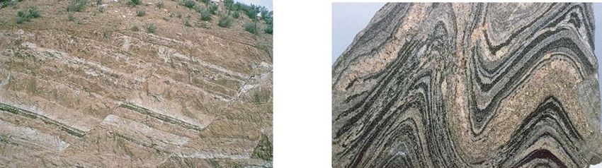
in time - the same as with the ice cores.
The nearly flat layering of the Grand Canyon can easily become warped and broken. When
things get cold, they tend to break under stress, but when they are hot, they tend to stretch and
bend (you’ll hear more about this in Professor Helfand’s lectures). Rocks are the same way. At
the Earth’s cool surface, brittle deformation causes rocks to break. A fault is a break
accompanied by motion (e.g. the San Andreas Fault), usually from an earthquake, whereas
fractures or joints might simply be cracks due to freeze-thaw cycles (Fig. 2). Deeper in the Earth,
increased pressure and temperature cause rocks to undergo ductile deformation and fold (Box 2).
When the temperature rises sufficiently, the chemical constituents of sedimentary rocks react to
create new minerals and new textures. This process of transformation is called metamorphosis.
In this lab, you’ll see the Manhattan Schist, which is an example of a metamorphic rock (BOX
I).
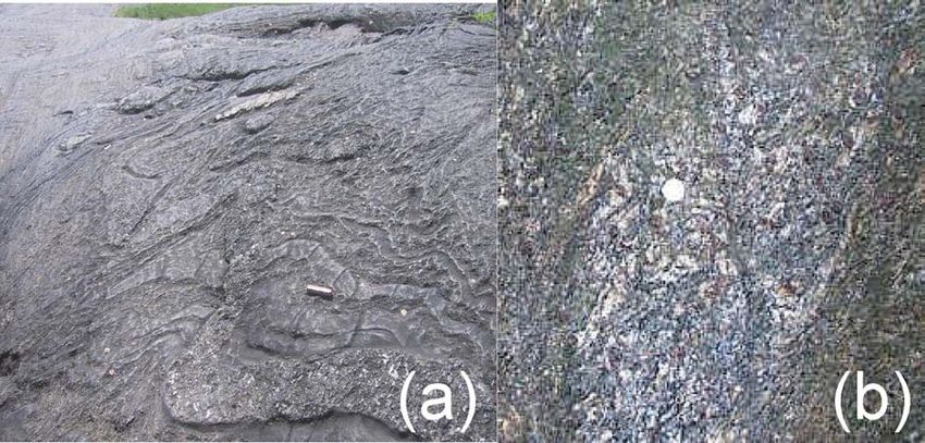
BOX I: MANHATTAN SCHIST IN THE FIELD.
(a) A typical Central Park outcrop of schist. The elongated layers of bedding or “foliation” are prominent in this
image; it is highly folded and weathered such that some layers stick out more than others. (b) This schist is
typical of outcrops in Inwood Park. Metamorphic minerals called garnets (the red-colored knobs) and mica
(shiny silver platy flecks) are prominent in this image. The highly deformed and folded structure is still evident.
Both images contain a familiar “object for scale” (a Swiss army knife and a dime respectively). All pictures and
sketches from the field require such a reference mark – otherwise it isn’t clear if the image is the size of your
fingernail or a mountainside.
Page 2 of 9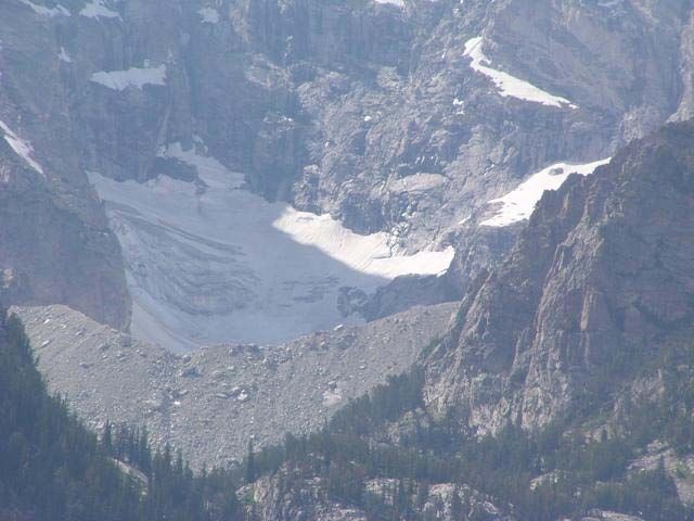
The Manhattan Schist – The bedrock of New York City

Most of Manhattan is underlain by the Manhattan Schist (BOX I), the bedrock that supports New
York’s towering skyscrapers. Have you ever wondered why there are no tall buildings in
Greenwich Village while midtown and downtown are full of skyscrapers? Manhattan schist is
found 18 feet below the surface in Times Square and 260 feet below in Greenwich Village.
Where the schist dips down skyscrapers are much more difficult to construct because there is no
bedrock to provide structural support. Greenwich Village remains a low-lying neighborhood, but
skyscrapers dominate midtown and the financial district where schist lies close to the surface.
Similarly, the supports for the George Washington Bridge are on Manhattan Schist. To
understand the history of New York City, you have to start 500 million (5x10⁸) years ago in the
Paleozoic Era.

                                           Figure 3: A map of bedrock geology reveals the
                                           patterns and structures made by the rock units in the
                                           Earth’s crust. This map is presented either in map
                                           view (or “birds eye” view) (a), or it can give a cross
                                           sectional view (b). Because each view is only a two-
                                           dimensional slice, we need both views to understand
                                           three-dimensional rock structures.

                                          X                                                         Y
       X
                                           New Jersey                                   New York
                                           Palisades Sill
                                           (Triassic Volcanic Rock)
                     Y

                                                                                        Manhattan
                                                                                        Schist

                  A                                                    B

Page 3 of 9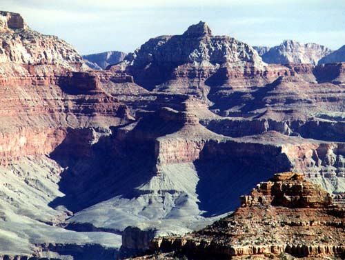
Figure 4 gives a sense of the vast history
of our planet. In this lab you’ll be
looking at rocks that are 500 million
years old, first deposited before the
evolution of plants. Even so, the rocks
you’ll see only represent the last 10% of
Earth’s history! These pages will
describe three important events in the
city during that time that will set the
stage for what you’ll be seeing on your
field excursion: the Taconic Orogeny,
the opening of the Atlantic Ocean, and
the glacial episodes of the recent
geological past, which you’ll learn about          Fig 4. Timing of some events in Earth history.
in lecture.

     The Taconic Orogeny

New York City bedrock began as muds and sands deposited 500 million years ago in an ocean –
the Iapetus Ocean – off the coast of what is now North America. These deposits were buried and
compacted, and eventually turned into sedimentary rock. Due to plate tectonics (for more info
see http://pubs.usgs.gov/publications/text/dynamic.html), an earlier Atlantic Ocean (the Iapetus
Ocean) closed as a massive chain of islands (analogous to Japan) collided into North America
between 480-440 million years ago. The once flat-lying sediments became folded and deformed
and were buried deep within a mountain range called the Taconic Mountains, which were a
massive range like the Himalayas. Beneath these ancient peaks, the sedimentary rocks were
heated, compressed, and metamorphosed to create the Manhattan Schist (Box I). A mountain
building event such as this is called an orogeny. During the last major collision at 310-250
million years ago, all of the continents came together to create one supercontinent called Pangea,
meaning “all Earth” (Fig. 5).

Where are these mighty peaks now you might ask? As far as mountains are concerned, if you
aren’t on your way up, you are on your way down. After the collision ended the once high and
mighty Taconic Mountains eroded away and eventually exposed their ancient metamorphosed
core, including the Manhattan Schist, for your viewing pleasure.

Page 4 of 9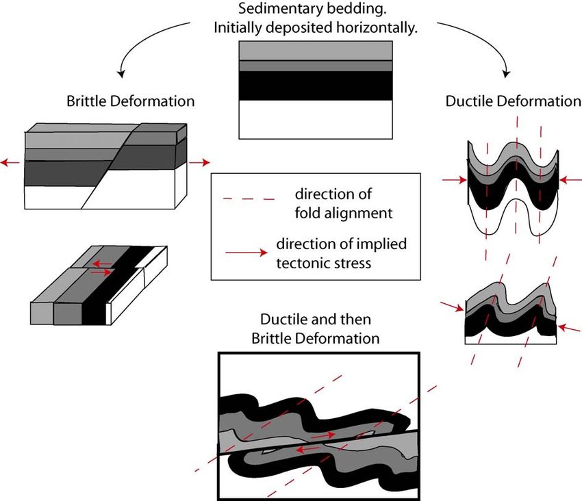
BOX II: BRITTLE VS DUCTILE DEFORMATION
 We all know that rocks near the surface of the Earth behave in a brittle manner: they fracture
 and fault in response to stress. As we go deeper in the Earth the strength of these rocks
 initially increases. At a depth of about 15 km we reach a point called the brittle-ductile
 transition zone. Below this point rock strength decreases because the temperature is higher.
 The rocks behave in a ductile manner; they fold and deform like stiff taffy.

Page 5 of 9
The Opening of the Atlantic Ocean

                                                            Pangea began to “rift” apart ~200 million
                                                            years ago at the end of the Triassic Period –
                                                            the beginning of the age of dinosaurs – when
                                                            the Americas began to pull apart from Europe
                                                            and Africa, and again forming mountains and
                                                            valleys (rifting creates long linear valleys
            Figure 5
                                                            with mountain ranges on each side – Nevada
                                                            is composed entirely of long rift valleys with
   Fig. 5
                                                            mountains on each side). Manhattan lies
                                                            within this ancient rift valley, which filled
                                                            with sediment from the mountains.

Virtually all large rifts on the Earth’s surface have volcanoes. When continents rift apart, hot
molten rock (magma) from the Earth’s interior fills the gap in the form of volcanoes and dikes.
The cliffs across the Hudson from Manhattan are composed of a great block of cooled magma –
the Palisades – that forced its way into the sedimentary layers in the rift during the break-up of
Pangea. In the field, you might also see smaller dikes cross-cutting the bedding in the Manhattan
Schist.

Since the break-up of Pangea there have been no more orogenies in New York. Running water
and moving ice have eroded the mountains and valleys. The Palisades and the Manhattan Schist
are exposed today because they are harder and more difficult to erode than the surrounding
sediments. In the field, you’ll see evidence of ancient orogenies and rifting.

In summary, these geologic processes - orogeny, erosion, and rifting - created the rocks in
Manhattan that you will see on your field excursion.

            The Glacial Age of the Last 450 Thousand Years

            In 1815, the Swiss mountaineer Jean-Pierre Perraudin communicated to the scientific
            community a radical notion:

        Having long ago observed marks or scars occurring on hard rocks which do not weather, I finally
        decided, after going near the glaciers, that they had been made by the pressure or weight of these
        masses, of which I find traces at least as far as Champsec. This makes me think that glaciers filled
        in the past the entire Val de Bagnes, and I am ready to demonstrate this fact to the incredulous
        people by the obvious proof of comparing these marks with those uncovered by glaciers at
        present.
                                                  - Quote excerpted from “Ice Ages” by Imbrie and Imbrie

You have read in Alley’s book how ice cores from Greenland and Antarctica record the last
seven glacial episodes in their d18O chemistry, extending back in time nearly half a million years.
The ice core record, however, was a relative latecomer in our understanding of our planet’s
glacial past. Evidence that ice had previously reached low latitudes was recognized by

Page 6 of 9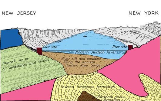
Europeans, such as Perraudin in the 1800s, before the discovery of the atom and long before the
concept of isotopic fractionation between 18O and 16O. Among the many achievements of
Charles Darwin was his recognition that certain sediment deposits in England, and the U-shaped
valleys of Scotland, were formed by glaciers.

Figure 6 shows an artist’s representation of the ice cover during the last glacial maximum, which
ended about 12,000 years ago. We know that the ice extended all the way to New York. (In this
sense, the idea in the movie The Day After Tomorrow, that the ice can reach New York is not
farfetched).

                                             To understand the physical signature of the ice
                                             ages, one needs to understand the physics of ice.
                                             Fresh snow is fluffy and loose (density ~0.14
                                             g/cm3). Like mud and sand transform into harder
                                             sedimentary rocks under pressure, snow too
                                             becomes compacted to form firn, or very dense
                                             snow (density ~0.8 g/cm3). Further compaction
                                             results in the dense crystalline mineral ice. Glacial
                                             ice has a density of ~ 0.9 g/cm3. Ice can be folded
                                             and faulted under stress and pressure just like the
                                             rocks that made the Taconic Mountains. When
                                             enough pressure causes the ice to flow and deform,
 Figure 6
                                             it is called a glacier.

Figure 7 shows a cross section through a glacier. Snow is
replenished in the winter in the zone of accumulation and
snow is lost in the summertime in the zone of ablation. The
mass balance that is struck between these two processes
determines whether the glacier will advance or retreat (get
smaller). Climate is the main influence on mass balance. A
glacier “retreats” when it melts faster than it advances.
                                                               Figure 7

Glacial Landforms Large and Small

The first step in glacial erosion is rock failure. Rock failure can occur as the growth of pre-
existing cracks or the formation of new cracks. Cracks form at weaknesses within the rock.
When water that has infiltrated into cracks freezes into ice it expands up to 10% in volume
(again, because ice is less dense than water – see BOX III). The expansion forces the crack to
widen, a process known as frost action.

The other significant erosional process is abrasion. Debris lodged in the ice grinds into the
bedrock and scars the rock in way that is consistent with how coarse the debris is (just as with
sandpaper on wood). This grinding can leave a finely polished surface or long grooves in the
bedrock called striations (Appendix III). Glacial striae are linear scratches in the bedrock
caused by ice and debris flow. They can occur at all scales, from microscopic scratches to
centimeter wide grooves, to foot wide troughs. (For example, a glacial trough might contain

Page 7 of 9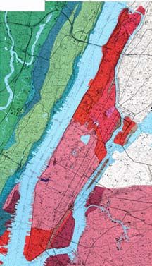
BOX III: HOW GLACIERS FLOW                   smaller grooves within it, and these
                                                           are likely to have scratches that can
                                                           only be seen with a microscope –
                                                           they are all examples of glacial
                                                           striae). Glacial striae are cut into the
                                                           existing bedrock in an orientation
                                                           consistent with the direction of ice
                                                           flow. For this reason, they are often
                                                           at an oblique angle to the bedding.
                                                           [Note: bedding - the sedimentary
   For most compounds, including rock, solids are          layering in the bedrock - can look
 denser than liquids. Because of this property, high       “grooved” as well due to differing
 pressures make rocks less likely to melt because          rates of erosion. Be careful!]
 pressure pushes atoms together. The compound H2O
 possesses a very peculiar property: the liquid form
                                                           If the glacier is no longer present,
 (water) is more dense than the solid (ice) – you know     striations can be used to determine
 this because ice floats. Application of pressure causes
                                                           the direction of ice flow.
 ice to melt, and pressure release causes refreezing.
 Push two ice cubes together with force and then let go
                                                           Unlike rivers or streams, glaciers can
 – they stick!
                                                           move any size particle. Large
                                                           boulders left behind by melting
 A glacier works in the same way: high pressures at the
                                                           glaciers such as this are termed
 base cause the base to flow along at rates of a
                                                           e r r a t i c s because they bear no
 millimeter to a meter per day. While ice at the base
                                                           relation to the surrounding bedrock.
 flows and deforms in a ductile manner, ice at the
                                                           Also, while streams erode bedrock to
 surface fractures and creates crevasses, or brittle
                                                           create “V-shaped” valleys, glaciers
 deformation.
                                                           create broad erosional features called
                                                           U-shaped valleys (Fig. 8) and fjords.
                                                           The relationship between U-shaped
                                                           valleys and glaciers were first
                                                           noticed in high mountains containing
                                                           mountain glaciers You will be
                                                           looking for glacial striations and
                                                           erratics during your lab exercise.

                                                           The end of a glacier is called the
 For the same reasons, glacial ice melts when it is        terminus and its position reflects the
 pressurized against a bump in the bedrock. On the         mass balance of the glacier in
 other side of the bump, the ice refreezes and plucks      response to climate. While the
 chunks off of the bedrock. The net result is a            glacier is advancing, it works like a
 landform called a roche moutoneé that is rounded and      plow, pushing everything in its path.
 smoothed on one side, and angular, blocky and steep       When the glacier retreats during a
 on the other. These forms occur in all sizes – from       warming period, it leaves its load of
 small outcrops to mountain range shapes. Some of          debris and creates a landform called
 you will be looking for these features in the field.      a terminal moraine (Fig. 8, and see
                                                           G l o s s a r y ). The sediment of a

Page 8 of 9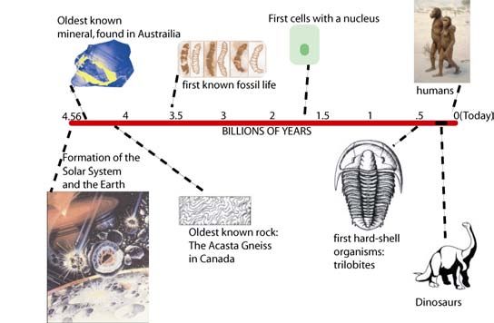
moraine is called till (a Scottish word for rocky soil). Till units are not size-sorted the way a
stream deposits are – with bigger particles falling out first and fine particles settling out later on.
Rocks carried by glaciers do not become sorted by mass as they travel down-slope (remember,
glaciers have unlimited carrying capacity).
Mapping the farthest advance of an ice front simply becomes a matter of mapping the limit of till
deposits which make up the terminal moraines. You’ll do this too!
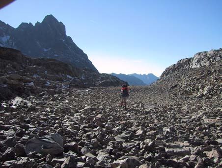
The boulder field (Wind River, WY) at left below is part of the terminal moraine of the last
ice sheet that covered North America. “Small” glaciers associated with high mountains
also make U-shaped valleys and terminal moraines as shown at the base of Teton Glacier,
WY (at right below).
Figure 8
Page 9 of 9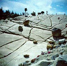
You can also read