Guadalupe-Blanco River Authority Guadalupe River Habitat Conservation Plan Second Public Stakeholder Meeting December 12, 2022 - NATHAN PENCE ...
←
→
Page content transcription
If your browser does not render page correctly, please read the page content below
Guadalupe-Blanco River Authority

Guadalupe River
Habitat Conservation Plan

Second Public Stakeholder Meeting

December 12, 2022
N AT H A N P E N C E
E X E C U T I V E M A N AG E R O F E N V I R O N M E N TA L S C I E N C E
Introductions: GBRA Staff and Consultants
      •   Nathan Pence
           Executive Manager of
           Environmental Science                     Project Management,
           npence@gbra.org                                HCP, NEPA
                                                                                     Water
      •   Chad Norris                                                                Quality
           Deputy Executive Manager of   Mussels
           Environmental Science
           cnorris@gbra.org
                                                                                    Water Quantity
      •   Jana Gray
            HCP Coordinator
            jgray@gbra.org
                                                                           Suzanne
                                                                                    Facilitation
                                         ESA Legal                         Schwartz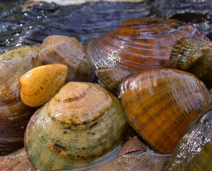
Meeting Agenda
•   Meeting Purpose / Overview of Agenda
•   Fundamentals of Habitat Conservation Plans
•   Follow-up from the First Stakeholder Meeting
•   Update from the Technical Advisory Group
•   GRHCP Covered Activities
•   GRHCP Hydrologic Modeling Approach
    •   Surface Water Quantity Modeling
    •   Water Quality Modeling
• Input Session Explained
• GRHCP Website
• Next Stakeholder Meeting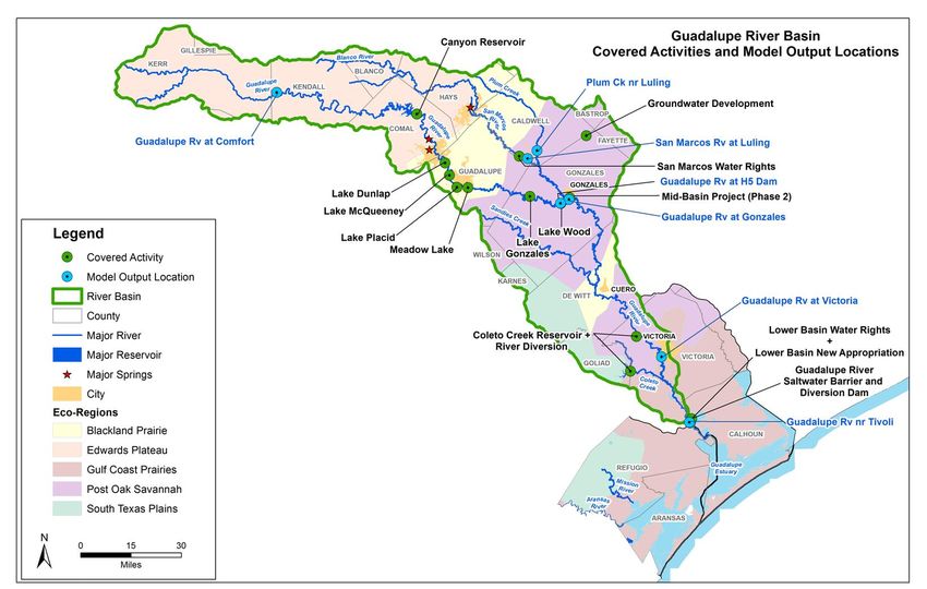
Fundamentals of Habitat Conservation Plans

                 • Take: action of or
The                attempt to hunt, harm,
                   harass, pursue, shoot,
Endangered         wound, capture, kill,
Species Act        trap, or collect a
                   species
prohibits        • Harm: any act that
take of listed     kills or injures species,
                   including significant
species            habitat modification or
                   degradation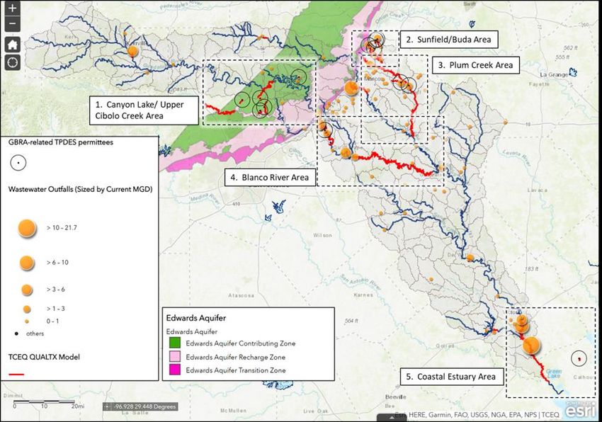
Fundamentals of Habitat Conservation Plans
• Purpose of a Habitat Conservation Plan
 o Allow GBRA to legally proceed with an activity that would otherwise result in the
   unlawful take of a listed species
• What is it?
 o A plan to mitigate for GBRA’s potential impacts to federally protected endangered
   species
• What it is not?
 o Not a re-do of the Environmental Flows planning process.
 o Not a general conservation planning process
 o Will not cover all GBRA’s conservation efforts
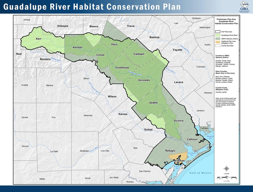
Follow-up
from First
Stakeholder
Meeting
Revised GRHCP
Plan Area
Follow-up from First Stakeholder Meeting
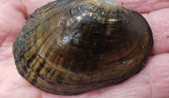
Species considered but not covered:
• American Eel
• Guadalupe Bass
• Sea Turtle
• Cagle’s Map Turtle
• Jaguarundi
On the Website:
• References and literature used in development of the GRHCP
• Provide links to other HCPs with 30 or 50 - year permit terms
• Recording of the meeting can be found at:
https://www.gbra.org/environmental/habitat-conservation-plan/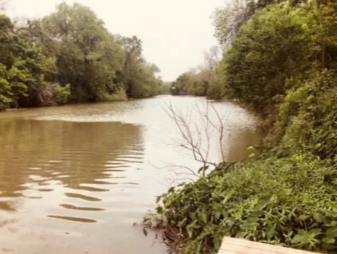
Update from the Technical Advisory Group
  Members:

             Dan Opdyke                          Cindy Loeffler
             Chair of Committee                  Retired TPWD
             Anchor QEA                          Texas Water Policy and HCPs
             Water quality and hydromodeling

             Webster Mangham                     Ryan Smith
             Trinity River Authority             Texas Nature Conservancy
             Mussel Policy and River Authority   Texas water and ecosystems
             operations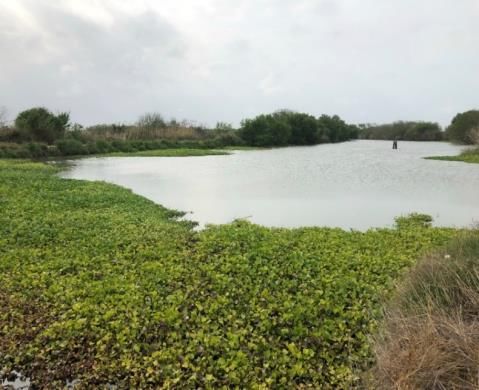
Technical Advisory Group Activities
• TAG may review any and all draft technical memos and HCP chapters, but will focus on
  technical issues
• First formal meeting was held October 3, 2022
• Comments have been provided on the following memos
         • Project goals                • Covered activities
         • Permit term                  • Existing information on species
         • Covered species              • Hydrologic modeling needs

• Additional memos will be reviewed in the coming months
• Changes in response to TAG comments will be reflected in HCP chapters
GRHCP Covered Activities -
 Methodology

Location            Timing              Impact               Control            Data
                                           Reasonable
                                                                Is/could be,       Sufficient
                                           likelihood of
  Within the plan   Within the permit                           under direct      information
                                         resulting in take
       area               term                                control of GBRA     available to
                                          of ≥ 1 covered
                                                                    (COI)       evaluate impact
                                              species
GRHCP Covered Activity Types –
Preliminary List
Water Supply Use of water rights to divert, treat, and transport water to
Impoundment, Production, supply municipal, industrial, agricultural, and other water
Diversion & Delivery needs from GBRA-owned and/or operated facilities.
Wastewater Collection and treatment of wastewater and discharge of
treated effluent from GBRA-owned and/or operated
Treatment/Discharges facilities.
O&M of Dam Facilities (and In-stream dams and associated power-generation plants
and other infrastructure from GBRA-owned and/or operated
failed structures) facilities.GRHCP Covered Activity Types –
Preliminary List
Other In-stream Various localized infrastructure in the Guadalupe River or
Infrastructure major tributaries owned and/or operated by GBRA.
Water Management Various activities related to managing water in the
Guadalupe River or major tributaries from GBRA-owned
Activities and/or operated facilities
Distribution and Underground and overhead pipelines and cables to
transport water, wastewater, electricity, and other services
Utility Lines from GBRA-owned and/or operated facilities.GRHCP Covered Activity Types –
Preliminary List
Parks/Recreation Facilities O&M of various parks and park facilities owned and/or operated by GBRA
Permitting Issuance of GBRA permits for waterfront construction
Administration & Construction and O&M of various administration and maintenance
Maintenance of Buildings buildings/facilities owned and/or operated by GBRA.
GRHCP Implementation & Habitat restoration, research/sampling/monitoring efforts, and other
conservation measures with the primary purpose of mitigating impacts to
Other Conservation Activities species by covered activitiesWhy Model?
• Inform decision making for GRHCP
• Assess Impacts from Activities –
Water Quantity and Quality
• Quantify take estimates for GBRA
Species
and 2nd party stakeholders
Habitat
Model
• Evaluate resiliency of conservation
measuresGRHCP Hydrologic Modeling Approach
Surface Water Quantity
General Approach: TCEQ Permits - Return
Flows
• Use Water Availability Model (WAM) for
the Guadalupe - San Antonio (GSA)
River Basin
• Provide monthly (daily) regulated Flow
streamflow estimates at specific Water
Qx,t
Usage WAM
locations throughout the entire basin Estimates
• Simulate all existing surface water
rights and major reservoir operations in
SW/GW
the basin Interactions
• Simulate assumed hydrologic and water Sediment in
Reservoirs
management conditions
Qx,t is flow estimate at time (t) and location (x)GRHCP Hydrologic Modeling Approach – Surface Water Quantity Selected Streamflow Locations* for Model Output 1. Guadalupe River at Comfort 2. Guadalupe River at H5 Dam 3. San Marcos River at Luling 4. Plum Creek near Luling 5. Guadalupe River at Gonzales 6. Guadalupe River at Victoria 7. Guadalupe River near Tivoli * USGS Gage Station
GRHCP Hydrologic Modeling Approach
                            Current (2020)                          Future (2070)
                                                     • Firm Yield of Canyon Lake under 2070
                       Average of 2010-2020 reported conditions
Water         GRHCP          surface water use       • Full authorized consumptive use under all
Quantity                                             other GBRA water rights
Assumptions                                           • Municipal - using population/water use
                       Average of 2010-2020 reported
               Non-                                   projections from 2022 State Water Plan
                        surface water use for all use
              GRHCP                                   • Industrial - No change from current use
                                    types
                                                      • Irrigation - No change from current use
                                                     • Estimate using population projections from
                                                     2022 State Water Plan
              Return   Average of 2010-2020 reported • Conservation assumption – 25% reduction
              Flows          surface water use       from current
                                                     • Reuse assumption – 50% reduction of
                                                     increased amount
GRHCP Hydrologic Modeling Scenarios – Surface Water Quantity
Scenario Purpose Flow and Related Attributes
Reference Determining Baseline Current water management in
the basin without GBRA +
second parties covered
Initial activities
Scenarios
Covered Activities Impact Analysis Current water management in
the basin with future GBRA +
second parties covered
activities.
Scenario Purpose Flow and Related Attributes
Climate Change Evaluate resiliency of future Use future evaporation,
mitigation efforts precipitation, and streamflow
Subsequent projections
Scenarios Conservation Strategy (up to Assess extent to which Proposed future operational
two scenarios) conservation measures flows, conservation flows,
mitigate take and restoration
Supplemental (if needed) TBD TBDGRHCP Hydrologic Modeling Approach
Overview
TCEQ Permits -
Return Flows WQ TCEQ Permits -
Effluent Limits
Climate Model
Scenario
Take
Flow Estimates
Water i
Usage WAM Qx,t WQx,t
Estimates
SW/GW
Interactions
Sediment in
Species
Conservation
Conservation
Reservoirs Habitat Strategy
Strategy
Model
Qx,t is flow estimate at time (t) and location (x)
WQx,t
i is the value of the water quality parameter (i) at time (t) and location (x)GRHCP Hydrologic Modeling Approach
Water Quality
General Approach
• Water quality modeling will be used to assess how the predicted flows
(streamflows and wastewater treatment plant return flows) can impact
water quality in the basin.
• TCEQ’s standard model (QUAL-TX) will be used as the water quality
modeling platform.
• QUAL-TX Models are used in permitting for TPDES outfalls and are used
for determining effluent limits to protect dissolved oxygen standards in
receiving streamGRHCP Hydrologic Modeling Approach
Water Quality
Key water quality constituents considered will
be Dissolved Oxygen, Temperature, and
Ammonia.
Assumptions
• Monthly flow estimates from WAM will be
discretized into daily flows to calculate the
7Q2 critical flow.
• Each GBRA discharge in the future
scenarios will have the same permit limits
as they have today – excluding discharge
volume.GRHCP Hydrologic Modeling Approach Water Quality Five Water Quality Modeling Focus Areas 1. Canyon Lake/Upper Cibolo Creek Area 2. Sunfield/Buda Area 3. Plum Creek Area 4. Seguin/Gonzales Area 4. Seguin/Gonzales Area 5. Coastal Estuary Area
GRHCP Hydrologic Modeling Approach
Overview
                   TCEQ Permits -
                    Return Flows                              WQ                  TCEQ Permits -
                                                                                  Effluent Limits
    Climate                                                  Model
   Scenarios

                                                                                             Take
                                       Flow                                                Estimates
    Water
    Usage             WAM                            Qx,t          WQx,t
                                                                         i
                                    Estimates

    SW/GW
  Interactions
                    Sediment in
                                                            Species
                                                                                        Conservation
                    Reservoirs                              Habitat                       Strategy
                                                             Model
   Qx,t   is flow estimate at time (t) and location (x)

   WQx,t
      i     is the value of the water quality parameter (i) at time (t) and location (x)
Input Session Explained Why are we holding these input sessions? •Give stakeholders an opportunity to provide input •Add to our base of information •Anticipate issues and refine our work •Inform how information is communicated in final document
Input Session Explained
Logistics
  • Break into four groups:
      o Go to easel pad with color indicated on your agenda
      o Each group will be facilitated by a Project Team member or GBRA staff
      o Experts will circulate among the groups
  • Virtual participants will provide input on the virtual platform
Discussion leaders will facilitate input on the following:
   •Comments on or concerns, or anything missed about the approach used
   for:
      o Covered Activities
      o Surface Water Quantity
      o Water Quality Modeling
gbra.org/environmental/habitat-conservation-plan
Information available on GRHCP
website:
• Upcoming and past meetings and events
• Proposed Covered Species
• Documents
o Technical Memoranda that have
completed the review process
o TAG overview and review process
• Maps
• Frequently Asked Questions
o References cited in Technical MemorandaNext Public Stakeholder Meeting Spring 2023 Topics of Discussion: • Climate Change • Species Impact Analysis
You can also read