Domestic Geographic Name Report - Oregon ...
←
→
Page content transcription
If your browser does not render page correctly, please read the page content below
Date submitted: March 26, 2021
Domestic Geographic Name Report
Action Requested: Proposed New Name
Recommended Name: Lark Island
State: Oregon
Administrative Area: Clatsop County
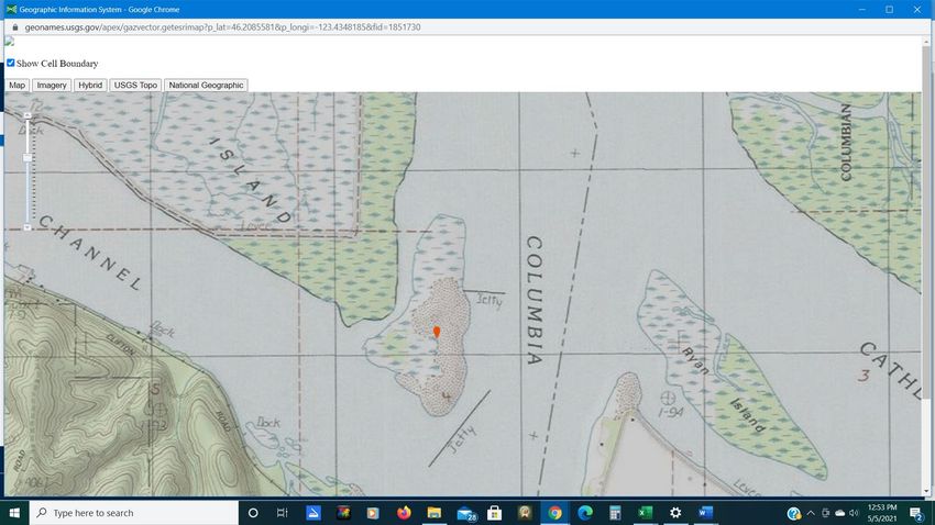
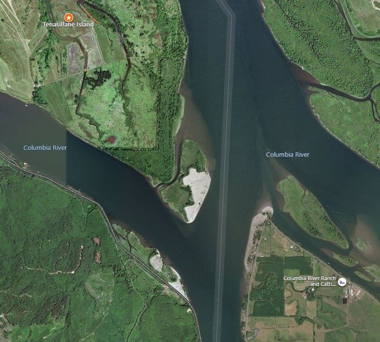
Specific Area Covered : Island in the Columbia River:
Center at N 46° 12’ 32.3” W 123° 26’ 4.2”
Township and Range: T8N R6W Willamette Meridian
Elevation 0 to 40 Feet
Type of Feature: Uninhabited Island
Is the feature identified (including other names) in the Geographic Names Information
System (GNIS)?: No
Description of Feature: Lark Island is a 113-acre island separated from Tenasillahe Island by a
navigable, unnamed slough on the west side and bordering the main channel of the Columbia
on the east side, across from Puget Island, Washington. It is approximately .9 mile long and .3
mile wide for much of its length, narrowing toward the northern end so that the island is roughly
horn-shaped. The NOAA chart still shows much of the island in green, or subject to be
inundated by highest tides, but this is no longer true - the Army Corps of Engineers uses the
island for depositing dredge material so that the majority of the island is currently at 40 feet
elevation.
Name Information (such as origin, meaning of the recommended name, historical
significance, biographical data (if commemorative), nature of usage or application, or any
other pertinent information):
Lark Island is one of the few remaining nesting areas for a rare subspecies of Horned Lark. The
Streaked Horned Lark, Eremophila alpestris strigata, is the most colorful of the Horned Lark
subspecies. They once occupied open country from southern British Columbia through the
Rogue and Umpqua valleys in Oregon. They have now been extirpated from most of their
former range and number somewhere between 1170-1610 individuals (Altman, 2011). Among
the last strongholds of the larks are the dredge material islands of the Columbia River. Since the
bird was listed as Threatened under the Endangered Species Act in 2013, the U.S. Army Corps
of Engineers has managed the timing and placement of dredge material to benefit the larks,
which thrive in the sparse prairies which emerge two to three years after the deposit of sandy
dredge material. Unlike some other endangered species, the presence of Streaked Horned
Larks has not been controversial, since they thrive on this disturbance from the primary
economic activity on the islands. More information on the Streaked Horned Lark may be found
here: https://www.fws.gov/oregonfwo/articles.cfm?id=149489450
Reference: Altman, B. 2011. Historical and Current Distribution and populations of Bird Species in
Prairie-Oak Habitats in the Pacific Northwest. Northwest Science, 85(2):194-222.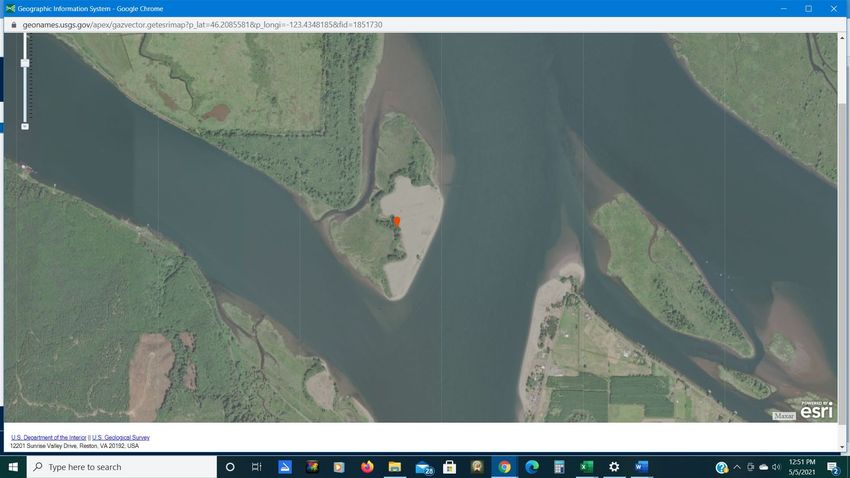
Maps and Other Sources Using Recommended Name:
The Lower Columbia River Estuary Partnership’s map of the Lower Columbia River Water Trail
lists Lark Island as a designated camping area:
https://www.estuarypartnership.org/water-trails/columbia-river
The page specific to Lark Island is here:
https://www.estuarypartnership.org/locations/campsite/lark-island-eastern-tip-of-tenasillahe-or
This is significant, for the only other name to which the island is referred is Tenasillahe, the
adjacent, larger island. Lark Island, however, is a separate island under different management.
Tenasillahe Island is part of the Julia Butler Hansen National Wildlife Refuge for the Columbian
White-tailed Deer, which expressly prohibits camping. Lark Island is managed by the Army
Corps of Engineers, and camping is permitted.

A 2005 Washington State Department of Natural Resources publication on Streaked Horned
Lark nesting success (see page 14):
https://cascadiaprairieoak.org/documents/Finalreport2005.pdf
This document notes that “Lark Island” is an unofficial name for the unnamed island.

eBird, the largest international database documenting bird distribution, abundance, habitat use,
and trends, lists Lark Island as a hotspot - a public area that is a good place to find birds:
https://ebird.org/hotspot/L6655727
Notably, Tenasillahe Island is listed as a separate hotspot.

Is the recommended name in local usage? Yes, for over 20 years
Is there local opposition to, or conflict, with the recommended name (as located)? No,
though a large number of local people simply call the island “Tenasillahe”, the name of the
larger, nearby island.

Other Names (variants) Tenasillahe

Maps and Other Sources Using Other Names or Applications:
This U.S. Army Corps of Engineers report “Maximizing Streaked Horned Lark Success Using
Strategic Placement of Dredged Material in the Columbia River”, by Kristine Lightner, October
24, 2018, refers to the island as “Tenasillahe” on a photo of the island and on their map of
Columbia River dredge material locations. This is available as a pdf file on line.

For proposed new name, please provide evidence that feature is unnamed: NOAA chart
18523 shows the island just SE of Tenasillahe Island as unnamed:
https://www.charts.noaa.gov/OnLineViewer/18523.shtml

Additional information: The reasons for officially naming the island “Lark” are two-fold.
The first is simply to avoid confusion. The only other name for the island in use is “Tenasillahe”,
but Tenasillahe is a separate island under completely different management. Tenasillahe is 2200
acres, most of it diked forest and pasture, managed by the U.S. Fish and Wildlife Service as a
part of the Julia Butler Hansen National Wildlife Refuge for the Columbia White-tailed Deer.
Lark Island is 113 acres mostly consisting of sandy dredge material, with some wetlands and
cottonwood forest along the slough that separates it from Tenasillahe Island. It is managed by
the U.S. Army Corps of Engineers, is a popular local fishing spot, and allows camping
(Tenasillahe does not).
The second reason for calling the island “Lark” is that the Streaked Horned Larks that nest there
are a large part of what make the island special. Their colorful plumage, bubbling song, and
dramatic breeding display are gone from most of their former range, yet they are thriving under
the Corps of Engineers’ management in this unlikely place. The hope of those who support this
name proposal is that highlighting the presence of this endangered bird will encourage people,
especially visitors to the island, to appreciate and protect it for future generations.

Submitted By: Andrew Emlen
140 Oatfield Road
Skamokawa, WA 98647
360-795-8009
emlenandrew@gmail.com
March 24, 2021

Authorities for Recommended Name:
George Exum and Carol Carver
Retired: engineer and director of St. James Family Center, respectively
541 West Birnie Slough Road
Cathlamet, WA 98612
360-849-4324
carver.exum@gmail.com
The Carver-Exums have lived on the western tip of Puget Island since 1979, directly across the
shipping channel from Lark Island. This makes them among the closest residents to Lark Island.
They have visited Lark Island many times.

Chris Hathaway
Community Programs Director, Columbia River Partnership
811 SW Naito Parkway, Suite 410
Portland, OR 97204
503-226-1565 x. 228
CHathaway@columbiariverpartnership.org
Chris started promoting the Columbia River Water Trail in 2001.

Kyleen Austin
Owner/guide, Columbia River Kayaking
422 East Birnie Slough Road
Cathlamet, WA 98612
360-849-9091
kyleenaustin@gmail.com
Kyleen first came to Puget Island in 2012. As an owner/ guide for Columbia River Kayaking, she
is one of the most frequent visitors to Lark Island.
Lark Island proposal 2021

                   Tenasillahe Island                                      WA

                                             Lark Island

     OR

                                                            Puget Island

              Tenasillahe Island
                                                                           WA
                                        Lark Island

       OR

                                                           Puget Island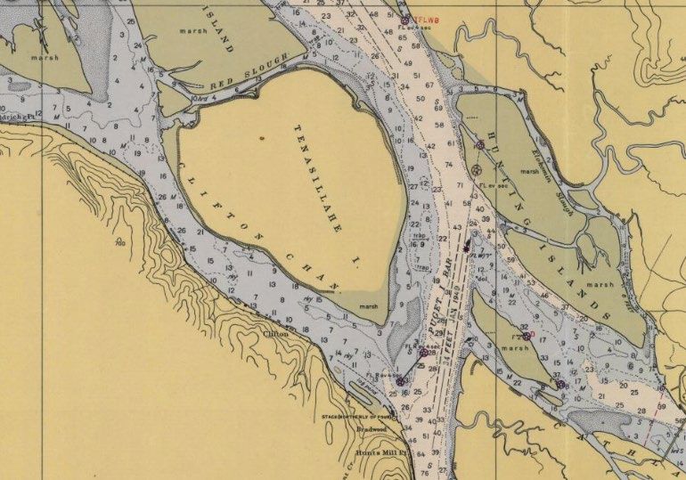
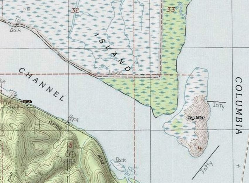
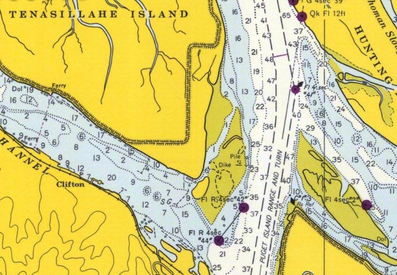
1971

   NOAA Navigation Chart 1948 Chart 6152

   NOAA Navigation Chart 1971 Chart 6152
z
Tenasillahe Island with new detached island.
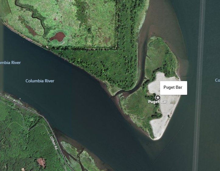
Tenasallahe Island and Puget BarPuget Bar is listed in GNIS as a ‘Bar’ not an island.
Bruce Fisher

Fwd: [EXTERNAL] Proposed geographic name "Lark Island"
Mark Flannery                       Tue, Jun 22, 2021 at 8:08 PM
To: Bruce Fisher , Champ Vaughan

 Here's a supportive response on Lark Island from Jackie
 Ferrier, of the Willapa National Wildlife Refuge Complex
 (USF&W). They manage the Julia Butler Hansen Refuge,
 adjacent to Lark Island.

 Mark
 ---------- Forwarded message ---------
 From: Ferrier, Jackie
 Date: Tue, Jun 22, 2021 at 8:58 AM
 Subject: Re: [EXTERNAL] Proposed geographic name "Lark Island"
 To: irenalfo@gmail.com
 Cc: Bonello, Jake E

 Hi Mark,

 We support the proposal to name the island adjacent to Tenasillahe Island within the Julia Butler Hansen
 Refuge for the Columbian White-tailed Deer, Lark Island.

 Thanks,
 Jackie

 ~~~~~~~~~~
 NOTE NEW ADDRESS & PHONE NUMBER:
 Jackie Ferrier
 Project Leader
 Willapa National Wildlife Refuge Complex
 7112 67th Place
 Long Beach, WA 98631
 360-642-3860

 From: Willapa, willapa@fws.gov
 Sent: Tuesday, June 22, 2021 7:55 AM
Bruce Fisher

Naming of an island in the Columbia River
WALKER Vicki * DSL                   Wed, Jul 21, 2021 at 6:41 PM
To: Bruce Fisher

 Hi, Bruce. We've determined the Dept of State Lands has ownership of the island. We do
 not oppose the proposed name of Lark Island and think the name is most appropriate.

 Thanks for your inquiry.

 Vicki

 Vicki L. Walker, Director
 Oregon Dept of State Lands
 (503) 986-5237 (w)
 (503) 798-2019 (c)

 Sent from my Verizon, Samsung Galaxy smartphone
 Get Outlook for Android

 From: Bruce Fisher
 Sent: Wednesday, July 14, 2021 1:34:57 PM
 To: WALKER Vicki
 Subject: Naming of an island in the Columbia River

 [Quoted text hidden]
You can also read