Hampton Court Circular walk - Saturday Walkers Club
←
→
Page content transcription
If your browser does not render page correctly, please read the page content below
Saturday Walkers Club                                                       www.walkingclub.org.uk

Hampton Court Circular walk
Two royal parks and Britain's finest surviving Tudor building.
Length            Main Walk: 12½ km (7.8 miles). Two hours 35 minutes walking time. For the
                  whole excursion including trains, sights and meals, allow at least 6½ hours.
                  Short Walk, starting from Hampton Wick: 9 km (5.5 miles). One hour
                  50 minutes walking time.

OS Map            Explorer 161. Hampton Court is on the Greater London/Surrey border, 3 km
                  SW of Kingston.

Toughness         1 out of 10.

Features          This walk explores the two royal parks next to Hampton Court Palace, with
                  the opportunity to spend time at the end in the palace grounds. After a short
                  stretch past the palace on the Thames Path the walk enters Home Park, the
                  local name for Hampton Court Park. It was originally enclosed as a hunting
                  ground for Henry Ⅷ and still contains a herd of fallow deer, but its
                  appearance has changed significantly since Tudor times. The Long Water
                  was added by Charles Ⅰ and the three lime tree avenues by William Ⅲ &
                  Mary Ⅱ, completing its transformation into parkland typical of the 17thC
                  baroque period.
                  The annual RHS Flower Show is held in early July but this should not affect the
                  suggested route through Home Park. However, the whole area will be much busier
                  than usual at that time.

https://www.walkingclub.org.uk/walk/hampton-court-circular/                                     1/10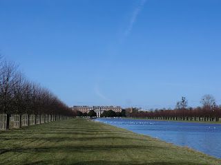
The walk leaves Home Park at Kingston Gate and crosses the A308 to enter
the larger Bushy Park. This too started as a royal hunting ground and has
had a similar evolution into more formal parkland. Its many water features
were the result of Charles Ⅰ ordering the construction of the Longford River
through the park to bring fresh water from the River Colne to Hampton Court
Palace. In the 20thC two attractive plantations were created along the course
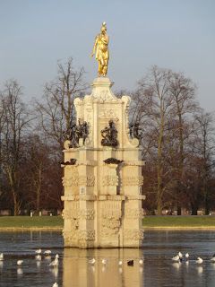
of the river and the walk goes through these Woodland Gardens to the
restored Water Gardens, another reminder of the park's baroque history. It
then loops back through the centre of the park and goes along part of the
mile-long Chestnut Avenue (with the iconic Diana Fountain as its
centrepiece) to Hampton Court Gate, opposite the palace's Lion Gates.
The Water Gardens are closed on Mondays (except Bank Holidays, when they are
closed on the Tuesday).
The final part of the walk is through the grounds of Hampton Court
Palace. This was originally built for Cardinal Wolsey, but when he fell out of
favour in 1529 it passed to Henry Ⅷ and was enlarged into a royal palace.
At the end of the 17thC it was again greatly extended by William & Mary,
who grafted a completely new baroque palace onto the Tudor buildings as
well as redesigning the surrounding parkland (but not perfectly: the king was
fatally injured by a fall when his horse stumbled on an ant hill). Full-price
admission to the palace buildings, maze and formal gardens is around £25
(2021) but there is often a 2-for-1 offer on the train companies' Days Out
Guide.
Although Historic Royal Palaces decided to end the free winter opening of the formal
gardens in 2016, the ‘informal gardens’ to the north and west of the palace buildings
are still freely open to the public.
Note that some of the parks and gardens along the route close around dusk.
Walk The Short Walk cuts out the first leg of the Main Walk by starting from
Options Hampton Wick station. There are also many short cuts which you could take
in Bushy Park, most drastically by omitting the 4 km loop out to the Water
Gardens.
Conversely, there are several ways of lengthening the walk slightly. In
particular it is well worth exploring the many attractive little paths inside the
Woodland Gardens rather than taking the straightforward route through
them described (for simplicity) in the walk notes.
There are bus routes along the roads around Bushy Park (but none through
it), so head for the nearest gate if you want to abandon the walk in the
middle.
Transport There is a half-hourly service between Waterloo and Hampton Court (in TfL
Zone 6), taking 36 minutes. For the Short Walk, Hampton Wick (also Zone 6)
is on the Kingston loop line with trains from Waterloo via both Wimbledon
and Richmond.
If you want to arrive in style (if not speedily) there is a summer riverboat
service from Westminster and Richmond to Hampton Court.
If driving, Hampton Court station car park costs £7.50 Mon–Sat, £3.50 Sun
(2021). There are free car parks inside Bushy Park, but these fill up quickly in
fine weather.
https://www.walkingclub.org.uk/walk/hampton-court-circular/ 2/10Suggested If you are planning to have lunch midway through the Main Walk at the café
Train in the centre of Bushy Park, take the train nearest to 10:30 from Waterloo
to Hampton Court. There are several other lunch and tea places (see
below) and in practice you could start the walk at any convenient time.
Lunch The most convenient place to stop for lunch is halfway round the walk at the
Pheasantry café (020-8943 1347; open to 5pm winter, 6pm summer), just
inside the entrance to the Woodland Gardens in the centre of Bushy Park. It
is likely to be busy on fine days but you have two chances to stop there for
refreshment as the walk loops back to it an hour or so later.
If you want a pub lunch you could stop earlier in Hampton Wick, after 4 km.
The Old Kings Head just outside Kingston Gate has closed, but a short detour
up the High Street would take you past the White Hart Hotel (020-
8977 1786) at #1, the Swan (020-8977 2644) at #22 (Thai food Mon–Sat;
no food Sun) and the Foresters Arms (020-8943 5379) at #45.
Tea If you have had an early pub lunch you could break for tea when you pass
the Pheasantry café (see above) for the second time. There are many
places towards the end of the walk at Hampton Court, including the
popular (but fairly expensive) Tiltyard café (020-3166 6971; open to
4.30pm) inside the palace grounds.
On the way to the station you pass some large pubs on the other side of the
main road, while a short detour into East Molesey will reveal a number of
independent cafés and more pubs. There is also a Coffee Bay kiosk in the
small station concourse.
Help Us! After the walk, we would love to get your feedback
You can upload photos to the ⬤⬤ SWC Group on Flickr (upload your photos)
and videos to Youtube. This walk's tags are:
swcwalks swcwalk240
By Car Start KT8 9AE
Help National Rail: 03457 48 49 50 • Travelline (bus times): 0871 200 22 33
(12p/min) • TFL (London) : 0343 222 1234
Version Jul-21
Copyright © Saturday Walkers Club. All Rights Reserved. No commercial use. No
copying. No derivatives. Free with attribution for one time non-commercial
use only. www.walkingclub.org.uk/site/license.shtml
Walk Directions
https://www.walkingclub.org.uk/walk/hampton-court-circular/ 3/10Walk Map All maps © OpenStreetMap contributors Walk Options M. Main Walk (12½ km) a. Short Walk, starting from Hampton Wick (9 km) Walk Directions If you are doing the Short Walk (from Hampton Wick), start at [10] in §B. https://www.walkingclub.org.uk/walk/hampton-court-circular/ 4/10
A. Hampton Court Station to Hampton Wick (4 km)

 1. Go straight ahead out of Hampton Court station, following signs to the palace. Stay on
    the right-hand side of the main road as you cross Hampton Court Bridge.
     Opened in 1933, this is the fourth bridge over the River Thames at this site. Upstream is Molesey
     Lock.
 2. On the other side of the bridge turn right onto Barge Walk, signposted as the Thames
    Path. You pass piers and mooring points on the river and Hampton Court Palace on the
    left, with the Tijou Screen in front of the Privy Garden.
     The elaborate wrought-iron screen was designed by Jean Tijou (a French Huguenot ironworker) for
     William Ⅲ's Privy Garden in the 1690s. When the baroque style went out of fashion the garden had
     been allowed to revert to a semi-wild state but was restored to its original appearance in the 1990s.
 3. At the end of the palace grounds the path splits into a cycle route and footpath (you can
    take either). In 400m go through Jubilee Gate in the park wall and then another gate
    into Hampton Court (or Home) Park.
 4. Keep ahead on a grassy path, taking care as you cross a number of golf fairways. You go
    through one of the long avenues of mature lime trees radiating out from the palace, then
    pass the tree-lined Oak Pond on your right and Farm Cottages on your left. Continue up to
    the Long Water and turn right to walk alongside it, away from the palace.
     Two new avenues of lime trees were planted alongside the Long Water in 2004 to recreate its original
     appearance.
 5. At the end of the Long Water turn left. Just after the start of an avenue of trees parallel to a
    tarmac lane on your right, bear left onto a track which leads to a surfaced lane in front of
    the Stud Nursery.
     This was built in the early 19thC when George Ⅳ used Home Park for breeding and training horses.
 6. Follow the lane round to the right and back towards the avenue of trees for a short distance,
    then turn half-left onto a clear grassy path.
 7. At the end of the final avenue of lime trees from the palace there are a number of path
    crossings; turn right at the second one.
 8. Follow the grassy path up to the right-hand side of the long Hampton Wick Pond and
    continue alongside it. At the end keep ahead and leave the park through Kingston Gate,
    passing the (closed) Old Kings Head pub on your left.

https://www.walkingclub.org.uk/walk/hampton-court-circular/                                              5/10
9. Unless you want to investigate other pubs in Hampton Wick, cross the A308 carefully at the
traffic lights and go up Church Grove to the pedestrian crossing by St John's church, where
there is a gate in the park wall on the left.
To detour through Hampton Wick turn right onto the A308, go over the pedestrian crossing
and keep left at the roundabout into its High Street. The White Hart Hotel is by the
roundabout, the Swan on the right at the junction with Lower Teddington Road and the
Foresters Arms at the junction with Park Road and St John's Road. Go to the end of
St John's Road to rejoin the main route at [11].
B. Hampton Wick to the Pheasantry Plantation (2¼ • 2¾ km)
10. Starting from Hampton Wick Station (+½ km)
a. Turn left out of the station and go along the main road for 250m, crossing over at some point
(there are pedestrian lights outside the station and also further on, by the Foresters pub).
b. After passing the Foresters Arms turn sharp right into Park Road and then immediately
left into St John's Road. At the far end go straight across Church Grove.
11. Opposite St John's church go through Church Grove Gate in the park wall, with a LOOP
waymarker.
The London Outer Orbital Path runs for 240 km around the edge of outer London. The route
through Bushy Park to the Water Gardens more or less follows this well-waymarked path.
12. At the far end of the tree-lined avenue go through another gate into Bushy Park. Keep
ahead briefly on a surfaced path, then bear right onto a broad grassy track.
13. At the corner of a cricket pitch turn half-right onto the right-hand of two grassy paths and
follow it towards the right-hand end of a wood 400m away.
14. At the edge of the wood bear left to come to a crossing point over a canal joining Leg-of-
Mutton Pond (on your right) and the next pond, 200m further on. Go over the canal and turn
left to walk alongside it.
15. At the end of the canal veer right and left to continue alongside Heron Pond, initially on a
surfaced path and then on a potentially muddy path by the water's edge.
16. Follow the path round to the right to continue alongside the Model Boating Pond. At the end
of this second pond keep ahead on a grassy path alongside a narrow water channel.
17. At the end of the channel turn half-left and make your way across the grass towards a
cast-iron water pump and Chestnut Avenue, the main road through the park.
The mile-long avenue was conceived by Sir Christopher Wren as a grand formal approach to Hampton
Court Palace. It is flanked on both sides by a row of horse chestnuts and several rows of lime trees.
18. Go straight across the avenue and head for a pedestrian gate in the boundary fence around
the Woodland Gardens, about 100m to the left of a vehicle entrance from the main road.
This area was originally fenced off in 1823 to protect a new plantation of oak trees from the deer. The
gardens were developed by the Park Superintendent in 1947, with informal clumps of rhododendrons
and azaleas around a channel of the Longford River. They consist of two enclosures separated by a
narrow strip of parkland, Ash Walk.
https://www.walkingclub.org.uk/walk/hampton-court-circular/ 6/1019. Go through the gate into the first enclosure, the Pheasantry Plantation. If you want to
visit the Pheasantry café, bear right to cross the stream at Crocodile Bridge and follow the
path up to the building.
If you are not visiting the café you could turn left instead of crossing the bridge, going
directly onto the main path through the plantation.
C. The Plantation to the Water Gardens and back (4 km)
20. Make your way to the main path through the Pheasantry Plantation, heading W. From the
café the shortest route is to head SW towards some small ponds, where you can cross a
stream at Duck Bridge and then turn right at a T-junction onto the main path.
21. Where the path splits into two you can take either route (or an earth path just off to the
right, alongside Keeper's River). All routes lead to a wooden gate at the western end of the
plantation.
22. Go out through this gate, straight across Ash Walk and through another gate into the
second enclosure, the Waterhouse Plantation.
23. For the simplest route keep right at the first two path junctions to head roughly NW on the
main path for 300m, then turn right at a T-junction to head N for 350m on a long straight
path.
a. For a more interesting route (using the map) you could detour off to the left and make your
way around Fisher's Pond to the larger Waterhouse Pond (with a small brick building on its far
side, the Water House).
In a glade to the north of Waterhouse Pond, the Canadian Totem Pole was erected in 1992 to
commemorate the country's links with Bushy Park. Upper Lodge was used as a convalescent hospital for
Canadian troops in WW Ⅰ.
b. Paths zig-zagging W and N alongside the Longford River allow for further detours off the main
path. 250m north of Waterhouse Pond there is a striking avenue of hornbeams connecting the
two routes.
The trees are a cultivar (Fastigiata) with upward-pointing branches creating a ‘cathedral’ effect.
24. At its northern end leave the plantation through a wooden gate and turn right. Go out
through another gate into the parkland and turn left onto a broad grassy path heading N,
with a fence on your left.
25. In 550m, where the main path crosses a small stream and turns half-right, there is a narrow
path off to the left leading to the Water Gardens.
To bypass these gardens (eg. on a day when they are closed) stay on the main path as it
goes round to the right, then turn right again onto a surfaced path leading away from the
gardens. In 100m turn right onto a surfaced lane and (for the simplest route) follow it for
800m to a seasonal car park. If you do this, resume the directions at [30].
https://www.walkingclub.org.uk/walk/hampton-court-circular/ 7/1026. For the main route, fork left to come to another surfaced path, which leads to a gate. Go
through this into the Water Gardens.
The Upper Lodge Water Gardens were created in 1710 by the Earl of Halifax, Ranger of Bushy Park,
but gradually fell into disrepair and were virtually forgotten by the 20thC. After a long campaign and
many years of detailed research they were eventually restored to their 18thC baroque style,
reopening in 2009.
27. Keep to the left of the Lower Pool and go past the central Cascade to the far side of the
Upper Pool, ignoring a bridge over the river leading to the Brewhouse (not open to the
public).
28. Leave through a gate in the wooden fence and follow the path round to the right. In 125m
turn right at a T-junction onto a surfaced lane, soon passing Upper Lodge on the right.
The present house dates from the 1840s; earlier buildings on the site were used as the Ranger's
official residence. It was used as a wartime hospital in WW Ⅰ and became part of Camp Griffiss in
WW Ⅱ, an important base for the US forces. The house is now part of the Crown Estate and privately
occupied.
29. After it curves right to head S, the simplest route is to follow the lane (which becomes
Cobbler's Walk) through the park for 1 km, gradually curving left and eventually coming to a
seasonal car park on the right.
a. Alternatively (again using the map) you could bear left off the lane onto a faint grassy path,
which in 150m goes past the right-hand end of the tree-lined Canal Plantation; the white
buildings beyond it are part of the National Physical Laboratory (NPL).
The NPL is the national measurement standards laboratory for the UK. The new buildings were
constructed between 1998 and 2007.
b. You can continue on more grassy paths roughly parallel to the lane, off to the right. You would
pass to the right of a house (Barton's Cottage) after 300m and later bear right in front of a
wood to rejoin Cobbler's Walk by the car park.
30. Take the broad grassy path heading SSE from the far end of the car park, heading for a
pedestrian gate in the wooden fence 300m away (well to the right of a more prominent
vehicle entrance).
The large house which comes into view behind you is Bushy House (originally Lower Lodge). This
former hunting lodge became the original site of the NPL in 1900 and is still part of the organisation.
31. Go through this gate to re-enter the Pheasantry Plantation. Inside the gardens the left-hand
path leads past Mediterranean Mound to the Pheasantry café.
If you are not visiting the café you could take the other path up to the ponds and across
Duck Bridge, then turn left at the T-junction to reach the gate by Crocodile Bridge.
https://www.walkingclub.org.uk/walk/hampton-court-circular/ 8/10D. The Plantation to Hampton Court Station (2¼ km)
32. From the café take the path heading SE to Crocodile Bridge and leave the enclosure
through the gate by which you entered on the outward leg.
33. Keep ahead on a broad grassy path heading S, to the right of a surfaced path. In 350m this
goes up a small bank where the Longford River flows into a culvert.
34. Veer left to head towards Chestnut Avenue where it circles around the Diana Fountain,
perhaps crossing the road into the basin for a closer view of the statue.
The Royal Parks controversially maintain that the bronze statue (gilded in its 2009 restoration)
actually represents the nymph Arethusa rather than the Roman goddess of hunting. It was
commissioned by Charles Ⅰ from Le Sueur in 1637 and originally stood at Somerset House. It was later
moved to the Privy Garden at Hampton Court before being installed as the centrepiece of Wren's
grand Chestnut Avenue in 1713.
35. Head S down the left-hand side of Chestnut Avenue and leave the park through Hampton
Court Gate. Cross the A308 at the pedestrian crossing and go through the imposing Lion
Gates into the grounds of Hampton Court Palace.
The Portland stone piers and wrought-iron gates were designed by Wren in the reign of Queen Anne
and her successor, George Ⅰ.
36. Start by forking right inside the Wilderness, alongside the hedge maze. At the first path
junction the entrance to the Maze is on your right.
The Wilderness was designed as a place for courtiers to wander along winding paths, not unlike the
now-famous Maze which was constructed for William Ⅲ in 1690.
37. Take any route through the Wilderness to the far right-hand corner. Go through an opening
in the brick wall into the Tiltyard and turn right for the Tiltyard café.
As the name indicates this area was used for jousting in Tudor times; above the café is the one
surviving brick tower used by spectators. William Ⅲ later divided the Tiltyard into the Kitchen Garden,
Rose Garden, etc.
38. Make your way from the café to the corner of the enclosure diagonally opposite, where
there are exits into the Rose Garden and the recently recreated Kitchen Garden.
The latter has been planted with vegetables, fruit and flowers typical of an 18thC kitchen garden.
39. Make your way out through the Rose Garden into the main forecourt. Ahead on your left is
the great Gatehouse into the Tudor palace, its entrance flanked by the King's Beasts.
These ten statues of heraldic animals (lions, dragons, unicorns, etc) represent the ancestry of
Henry Ⅷ and his third wife, Jane Seymour.
https://www.walkingclub.org.uk/walk/hampton-court-circular/ 9/1040. Leave the palace grounds by the main Trophy Gate (or one of the side entrances onto
Barge Walk) to come out onto the A309. Go across Hampton Court Bridge to the station.
There are some large pubs directly opposite the palace entrance, and more pubs and coffee
shops across the bridge in East Molesey. There is also a refreshment kiosk inside the
station.
» Last updated: July 2, 2021
© Saturday Walkers Club. All Rights Reserved. No commercial use. No copying. No
derivatives. Free with attribution for one time non-commercial use only.
www.walkingclub.org.uk/site/license.shtml
Saturday Walkers Club • © 2000-2021 All Rights Reserved •
saturdaywalkers@walkingclub.org.uk
https://www.walkingclub.org.uk/walk/hampton-court-circular/ 10/10You can also read