Hawaiʻi Fishing Spots - 2021 Kaulana Mahina Hawaiʻi Lunar Calendar
←
→
Page content transcription
If your browser does not render page correctly, please read the page content below
2021   Kaulana Mahina • Hawaiʻi Lunar Calendar

Hawaiʻi Fishing Spots
Since 1980, almost all of the black coral
harvested around the Hawaiian Islands
was taken by hand from a coral bed in
the Au‘au Channel at depths of 200+
feet. The channel is located between
the islands of Maui and Lāna‘i.

This has always been a high risk fishery
that requires substantial skill and focus.
With each descent, divers knew there
was a high chance it could be their last.
Ensuring that they took their time and
used their expertise allowed them to
continue to fish and tell their stories.

Currently, the harvest of precious corals
in the U.S. Exclusive Economic Zone
(3-200 miles offshore) is regulated
through annual catch limits developed
by the Council.

                                             This species of black coral (Antipathes griggi) can be found growing up to about 360 feet deep in
                                               the Au‘au Channel between Lāna‘i and Maui. Photo taken with the Hawai‘i Undersea Research
                                                                   Laboratory’s Pisces submersible. Photo: Sam Kahng, University of Hawai‘i.

Au‘au Channel
Black Coral Grounds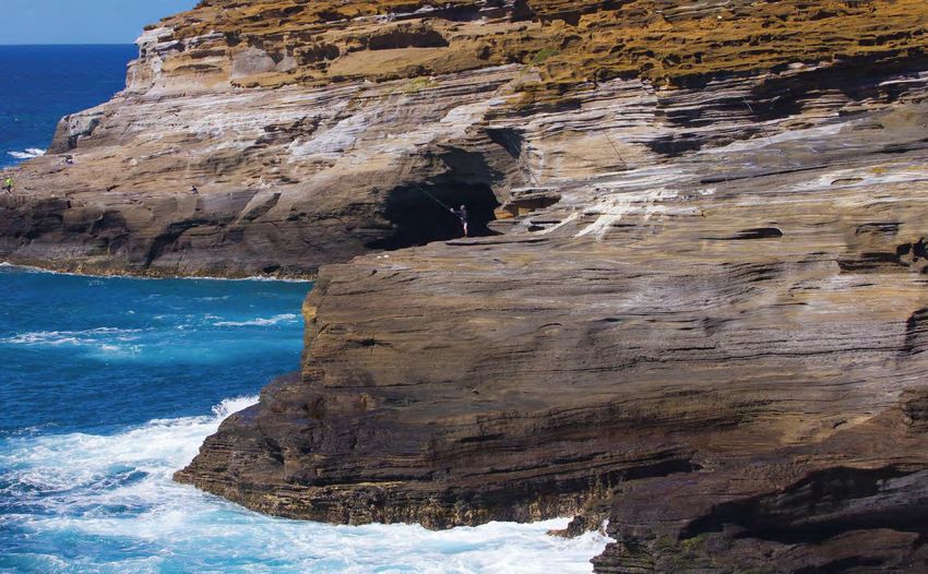
Penguin Bank

Penguin Bank, or “The Bottomfish Grounds,” is a
submerged shield volcano with reef habitat west of
Moloka‘i in the main Hawaiian Islands (MHI). This large
area supports coral and coralline algae at an average      Managing the bottomfish fishery has been
depth of 165 feet.                                         difficult due to insufficient fishery data.
Historically, Penguin Bank has been a popular location     However, with cooperation between state
to fish for bottomfish, including uku (grey snapper) and   and federal management agencies and
the Deep 7 bottomfish species (six snappers and one        fishermen, the Deep 7 bottomfish annual
grouper). It is particularly important for the MHI catch   catch limit increased from 178,000 pounds
of uku, one of few bottomfish species available in         for the 2007-2008 fishing year to 492,000
substantial quantities during summer months.               pounds for the 2020-2021 fishing year.
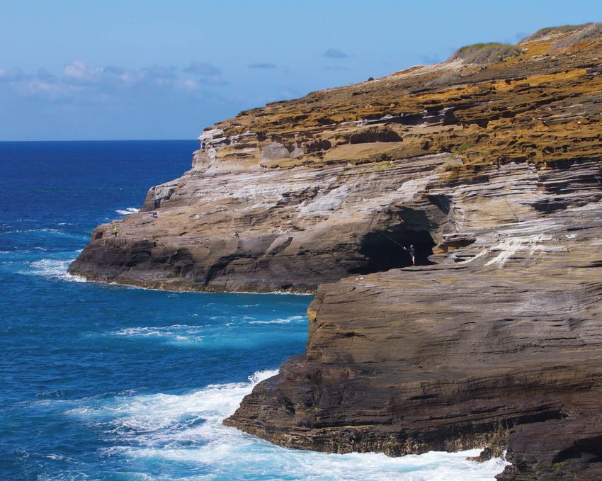
Bamboo Ridge
          Bamboo Ridge is a well-
          known shorecasting spot
          on the southeast shore
          of O‘ahu. The name
          originated from the
          bamboo fishing poles
          that lined the ridge.
          People who fish this
          area target ulua (giant
          trevally) using the slide
          bait method.

          Casting an ulua pole
          requires a unique set
          of skills and timing, but
          some fishermen solve
          the casting problem
          with exotic tricks such
          as using trash bags,
          kites or drones.

Maui
Community Fish
Aggregating Devices
In 2011, a project was piloted off Maui to help
understand the effectiveness of community
fish aggregating devices (CFADs). The
primary objectives of this data collection
program were to provide data on species
composition harvested near the CFADs, the
amount of effort to catch the fish and the
number of fishermen using the devices.            This 120-pound yellowfin tuna was
                                                     caught using a green stick near
                                                      the Mama’s Fish House CFAD.
                                                           Photo: Layne Nakagawa.
In 2013, Maui fishermen requested assistance
in redeploying two CFADs off of Kahului
Harbor. The Western Pacific Fishery
Management Council, Mama’s Fish House
restaurant and fishermen worked together
to redeploy the CFADs and Mama’s Fish
House has continued to collect data useful
for management measures.
Waiāhole Stream is one of the many streams
on the windward side of O‘ahu that input fresh
water into Kāne‘ohe Bay. This fresh-water
supply helps to support the nehu (Hawaiian
anchovy) stock that was historically used to
help fishermen catch larger game outside of the
bay, primarily for the aku (skipjack tuna) boat
fishery. In the past, dozens of aku boats would
set their nets in the shallows of Kāne‘ohe Bay.
The Japanese technique of catching with pole-
and-line and live bait resembled the aku fishing
method traditionally used by Hawaiians. The
modern fishing method uses live bait from a
fishing vessel to simulate a surface school of
fish in a feeding frenzy. He‘eia Kea Boat
Harbor on the windward (east) side of O‘ahu
was homeport for more than 20 boats. The
Hawai‘i skipjack tuna fishery originally supplied
only the local markets with fresh and dried tuna,
which then extended over into the local cannery
before World War II. The aku boat fishery was
once the largest commercial fishery in Hawai‘i
with landings exceeding 5.5 million pounds
annually from 1937 to 1973.
Kāne‘ohe Bay School of nehu.
Photo: James Watt, NOAA.Cross Seamount The Cross Seamount is a unique structure as The Cross Seamount tends to have a boom and the shallowest seamount (about 1,100 feet below bust cycle, which may be due to seasonality and the ocean surface) within the U.S. Exclusive migration patterns. The core group of fishermen who Economic Zone (3-200 miles offshore) around fish in this area view themselves as a community and the Hawaiian Islands. It is located approximately have agreed among themselves on rules and been 140 miles southwest of the Island of Hawai‘i. able to self-regulate. The type of fishing and gear used at the Cross Seamount includes troll, tuna handline, vertical line, deep-sea handline and a hybrid method that combines two or more fishing methods. Fishermen target and catch mainly bigeye tuna, yellowfin tuna, monchong (sickle pomfret) and mahimahi (dolphinfish).
The Cage
In order to meet
the growing
consumer demand
for fresh local fish,
Hawai‘i-based
aquaculture
companies
have worked to
successfully and
sustainably raise
and harvest
species like
Hawaiian kampachi
(amberjack or
kahala) in state
and federal waters.

These aquaculture
cages also act as
exceptionally good
fish aggregating
devices, increasing
catch rates of
ʻōpelu (mackerel
scad), tuna,
ono (wahoo)
and marlin.
                        Offshore aquaculture of Hawaiian kampachi in an Aquapod net pen. Ocean Era’s second aquaculture
                                   trial featuring about 2,000 kampachi in a copper-alloy cage moored in 6,000 feet of water.
                                                                                      Photo: Jeff Milisen and Ocean Era, Inc.
North Pacific Transition Zone
The North Pacific Transition Zone supports
a productive marine food chain due to changes
in nutrient levels. Animals found in this transition
zone include swordfish, tuna, albatross, whales
and sea turtles. The North Pacific plays an
important role for the shallow-set longline fishery
due to this environment and makes it ideal
to target swordfish.
The Hawai‘i-based longline fishery is a limited-
entry fishery with a hard cap of 164 permits. The
fishery operates in two distinct modes: the deep-
set longline targets bigeye and yellowfin tuna,
and the shallow-set longline targets swordfish
or mixed tuna species.
It is important to note that the shallow-set long-
line fishery has 100% federal observer coverage
with the purpose of documenting total catch and
bycatch. The sets from these boats are buoyed to
the surface with four large circle hooks between
floats and are relatively shallow (about 100-300
feet). These sets use light sticks to attract
swordfish that are primarily targeted at night.
A Hawai‘i longline vessel leaves Kewalo Basin
in Honolulu for its next fishing trip.
Photo: Joshua K. DeMello.South Point
South Point, or Ka Lae, located on the Island
of Hawai‘i is the southernmost edge of the
United States. Other than its beautiful scenery,
it is also known as one of the few fishing spots
where fishermen catch large pelagic fish from
the shore. Fish caught include ulua, bigeye and
yellowfin tuna, mahimahi and even marlin.
Anchors do not work very well at this location
since the ocean bottom drops off quickly to
great depths, which are ideal for pelagic fish.
Fishermen gaff and scale a 75-pound yellowfin tuna
up the steep cliff at South Point.
Photo: Joshua K. DeMello.Maro Reef
In the late 1970s, the National Marine Fisheries Service (NMFS),
U.S. Fish & Wildlife Service, Hawai‘i Department of Aquatic
Resources and University of Hawai‘i Sea Grant Program joined
in a cooperative agreement to conduct a 5-year assessment of
the resources around the Northwestern Hawaiian Islands (NWHI).
The survey showed that Maro Reef and Necker Island had large
enough stocks of lobster to support commercial fishing. While as many as
16 banks within the NWHI were fished each year, the majority of the fishing effort
was done near Maro Reef, Gardner Pinnacles, St. Rogatien Banks and Necker Island.
In the mid-1980s, the NWHI lobster fishery
was described as Hawai‘i’s most lucrative
fishery with a boom and bust cycle. All of
the participants used plastic, dome-shaped,
single-chambered traps. From 2001 to 2005,
NMFS did not issue harvest guidelines for the
NWHI lobster fishery due to a U.S. District
Court order to keep the fishery closed until an
environmental impact statement and biological
The Hawaiian spiny lobster
(ula, Panulirus maringatus) can opinion were prepared. The designation of
be found under ledges or in caves.
Fishing for lobster is prohibited the Papahānaumokuākea Marine National
from May through August by
the State of Hawai‘i. Monument in 2006 closed the fishery, and
NMFS has annually set the NWHI lobster
harvest guidelines as zero.The Grounds
Photo: Kevin Hibbard
“The Grounds” is a unique underwater ledge
off the coast of Kona. Upwelling near Ke‘āhole
Point, the westernmost point of Hawai‘i island,
makes these waters very productive. Fishermen
favor the onshore Kohala current over the off-
shore Maui current because it causes pockets
of feeding baitfish such as aku (skipjack tuna)
and oioi (frigate mackerel) to form along the
ledge. The local trolling and charter fishing fleet
from Kona harvests these smaller fish to target
blue marlin, ahi (yellowfin and bigeye tuna) and
other large predators.Pier 38
While not exactly a fishing spot,
businesses located at Pier 38 are
an extension of fishing near the
Hawaiian Islands.
Pier 38 is home to Hawai‘i’s
Commercial Fishing Village that
includes fresh fish distributors, fish
markets and restaurants, and fishing
supply stores. The Honolulu Fish
Auction is the only fresh tuna auction
of its kind in the United States. The
auction is based on the famous Tokyo
fish auction, where large fish are sold
individually rather than by the boatload.
This concept allows fishermen to sell
their fresh catch at a fair price to the
wholesale, retail and restaurant sectors.
The Honolulu Fish Auction was
originally located on River Steet and
sold reef fish in addition the pelagic
species sold today. This discontinued
due to the discovery that an increasing
number of local reef fish had a poison
in their tissues that is produced by
a certain microalgae and causes
ciguatera poisoning in humans.Northwestern Hawaiian Islands The Deep 7 bottomfish fishery in Hawai‘i is composed of six snapper species and one grouper species typically found at depths of 250-1,300 feet. Bottomfishers use a hook-and-line method of fishing in which weighted and baited lines are lowered and raised with electric, hydraulic or hand-powered reels. In the past, bottomfish fishing in the Northwestern Hawaiian Islands (NWHI) was conducted solely by commercial fishermen, and the vessels they used were larger than those fishing around the main Hawaiian Islands due to the greater distance they had to travel. Participation in the NWHI bottomfish fishery was controlled through limited access programs in two management zones (Mau and Ho‘omalu). NWHI bottomfish made up nearly half of the commercial landings of the total local catch. In 2006, President George W. Bush proclaimed the NWHI a Marine National Monument which eventually led to the closure of fisheries in that area on June 15, 2011.
About This Calendar                                                                                                          Hawai‘i Contacts
                                                                                                                             Council Vice Chair Edwin Watamura
The 2021 Kaulana Mahina (Hawaiʻi Lunar Calendar) features 13 fishing spots or locations found within or near the             Phone: (808) 538-6031
Hawaiian Archipelago that are important to fishermen. Each month highlights different aspects of the locations such          Email: watafishing@gmail.com
as an area description, historical and modern information, species commonly targeted and gear type used.                     Council Member Roger Dang
                                                                                                                             Phone: (808) 590-9921
The literal meaning of kaulana mahina is position of the moon. In the traditional Hawaiian calendar, each malama             Email: roger@freshislandfish.com
(month) was determined by the 29.5-day cycle of the mahina and divided into three anahulu (traditional 10-day period).       Council Member McGrew Rice
The first period was called ho‘onui (growing bigger), beginning when the first crescent moon was visible to the naked        Phone: (808) 960-1424
                                                                                                                             Email: mcgrewrice@gmail.com
eye. The second anahulu was poepoe (round or full). The last anahulu was emi (decreasing).
                                                                                                                             Council Member Suzanne Case
The calendar includes an observational space each month with hopes that others                                               Hawai‘i Department of Land &
will take up the practice of using the calendar as well.                                                                     Natural Resources
                                                                                                                             Phone: (808) 587-0401
                                                                                                                             Email: suzanne.case@hawaii.gov
Traditionally, nā pō mahina (lunar phases) are used to determine when specific
activities should take place, such as fishing times and spawning times when
harvesting of some species was limited. Moon phase and moon month names
could vary by island and moku (district). This calendar uses the moon phases
for O‘ahu listed in the Hawaiian Almanac by Clarice Taylor (1995. Honolulu:
Mutual Publishing). The tide charts with moon rise and set times were provided
by OceanFun Publishing, NZ. The lunar months, moon phases, and traditional
calendar months are given in Hawaiian.

Special mahalo to calendar contributors including Council Member McGrew Rice;
Council Advisory Panel members Clay Tam (chair), Gil Kuali‘i (vice-chair),                                                   Western Pacific Regional
                                                                                                                             Fishery Management Council
Nathan Abe, Basil Oshiro and Chad Pacheco; Council staff Joshua DeMello; Kevin Hibbard; Sam Kahng,                           1164 Bishop Street, Suite 1400
University of Hawai‘i; Jeff Milisen, Ocean Era; Layne Nakagawa; and James Watt, NOAA.                                        Honolulu, Hawaii 96813
                                                                                                                             Phone: (808) 522-8220
For an electronic version of this calendar, go to www.wpcouncil.org/educational-resources/lunar-calendars.                   Fax: (808) 522-8226
                                                                                                                             Email: info@wpcouncil.org

About the Council
                                                                                                                             Web: www.wpcouncil.org

                                                                                                                             Published in the United States by
                                                                                                                             the Western Pacific Regional Fishery
                                                                                                                             Management Council under NOAA Award
The Western Pacific Regional Fishery Management Council has worked with communities in Hawai‘i, American Samoa,              NA20NMF4410013.
Guam and the Commonwealth of the Northern Mariana Islands since 2006 to produce traditional lunar calendars to promote
ecosystem-based fisheries management, support indigenous fishing and management practices, and enhance community             © 2020, Western Pacific Regional Fishery
                                                                                                                             Management Council
involvement in the fisheries management decision-making process. In Hawai‘i, the Council strongly supports the traditional
‘aha moku system of natural resource management, which recognizes the traditional moku (districts) as a basis for cultural   ISBN 978-1-944827-67-0
and community consultation, adaptive management, education, general knowledge and a code of conduct. More information
                                                                                                                             Front Cover: Bamboo Ridge is a well-known shore-
and the ‘aha moku system can be found at www.wpcouncil.org and www.ahamoku.org. If your moku is interested in working        casting spot on the southeast shore of O‘ahu, popular
with the Council on a future calendar, please send an email to info@wpcouncil.org.                                           with fishermen who target ulua (giant trevally).
You can also read