HOPKINS CORRIDOR TRAFFIC AND PLACEMAKING STUDY - VIRTUAL COMMUNITY WORKSHOP #2 Transportation and Placemaking Opportunities | March 10, 2021
←
→
Page content transcription
If your browser does not render page correctly, please read the page content below
HOPKINS CORRIDOR TRAFFIC AND PLACEMAKING STUDY

V I RT UAL C OM M U N I T Y WOR K S H OP # 2
Transportation and Placemaking Opportunities | March 10, 2021
PROJECT TEAM
City of Berkeley
Beth Thomas Submit any project-related
Ryan Murray questions and comments to
Eric Anderson Project Questions? Ask me! via
Dianne Yee chat message
Matthew Cotterill
For help with how to use
Jesus Contreras
Zoom, send a chat message to
Consultant Team Need Tech Support?
Parisi Transportation
Consulting
PlaceWorks
PGAdesign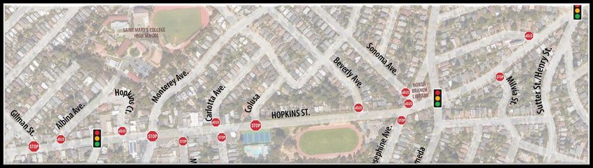
AGENDA 1. Welcome and Introductions 2. Presentation Workshop #1 Recap Transportation Opportunities Placemaking Opportunities 3. Small Group Exercise & Discussion 4. Report Back 5. Next Steps
ZOOM MEETING CONTROLS (DESKTOP)

                                    Choose
                        “Project Questions/    Type
                                              Message
                               Comments?”      Here
                              in drop-down
                                      menu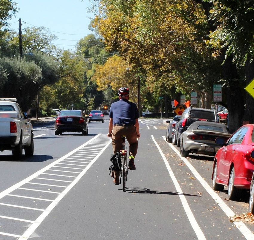
ZOOM MEETING CONTROLS (TABLET & SMART PHONE)

          Access the
         Chat Window
          First, click “More”

                       Tablet            Smart Phone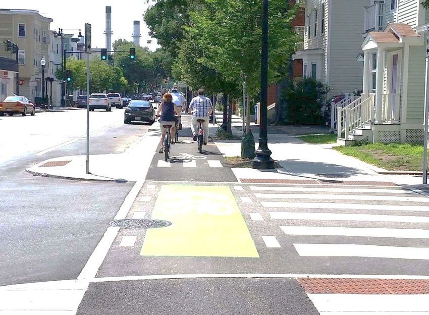
WORKSHOP PURPOSE

   • Share updated “complete streets” design improvements
   • Review options for incorporating landscape, gathering places, and
     public art
   • Listen to your ideas on the proposed measures for the Hopkins
     Corridor

                                                                         8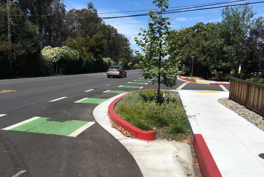
NEXT STEPS

 October                          Nov –           Conceptual Design
            Workshop #1                                                           March
  2020                             Feb                  Alternative
                                                                                  2021
                                 2020/21               Development

                                                                                          Workshop #2

  Workshop #3:                                                         March -
                          June             Conceptual Design and
  Conceptual Design                                                   June 2021
                          2021             Engagement
  Preferred Option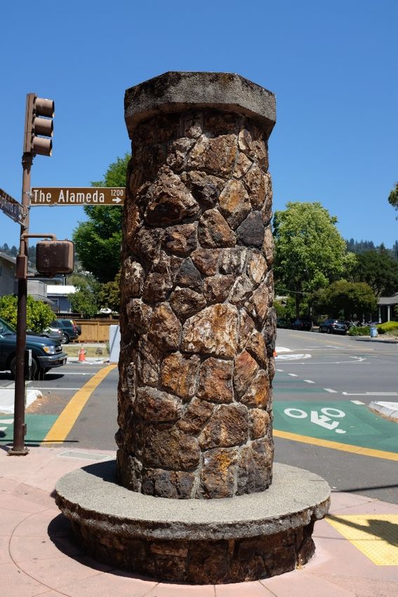
WORKSHOP #1 RECAP
EXISTING CONDITIONS
   City Priorities                      Berkeley’s Vision Zero
                                        Action Plan identifies
                                        priority actions, including
            The 2017 City of Berkeley   proactively building
            Bike Plan recommends        capital-intensive and
            Hopkins Street for a        quick-build safety
            complete street corridor    projects on all Vision Zero
            and cycle track study.      High Injury Streets by 2028.

Source: SWITRS 2015-2018                                          14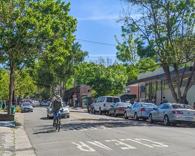
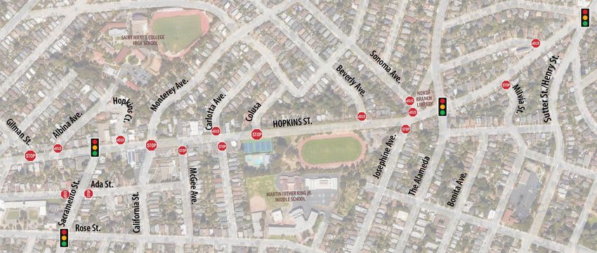
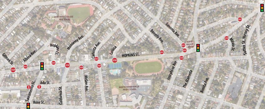
EXISTING CONDITIONS
               Street segments vary significantly by width and traffic volume.

                                                                    Sutter Street to
                                                                    Sonoma Avenue

                                                                                            Traffic Volume
Street Width

                                                            Sonoma Avenue to
                                                             McGee Avenue

                                                     McGee Avenue to
                                                      Gilman Street

                                                                                       15
EXISTING CONDITIONS
Collisions Who was
involved? Pedestrian - 11%
36 collisions took place
from 2015-2018. 36% of
all collisions involved
cyclists or pedestrians. Cyclist -
25%
One pedestrian fatality
and one cyclist fatality
Vehicle Only
occurred in the study - 64%
area from 2015-2018.
Source: SWITRS 2015-2018 16PARTICIPANT FEEDBACK
Pedestrian Crossing Safety
Speeding Vehicles/Need for Traffic Calming
Cyclist Safety/Facilities
Placemaking
Congestion
Percieved Usefulness of Traffic Calming Features
Safety Concerns around Traffic Controls
Parking Improvement
Cut-Through Traffc
Transit Facility Improvements
Emergency Vehicle Issues
Air Quality from Traffic
Sidewalks Too Narrow
Poor Pavement Quality
Driver Visibility Concerns
Conversion to One-Way
0 5 10 15 20 25 30 35
Sacramento St. Gilman St. to McGee Ave. McGee Ave. to Sonoma Ave. Sonoma Ave. to Sutter St.
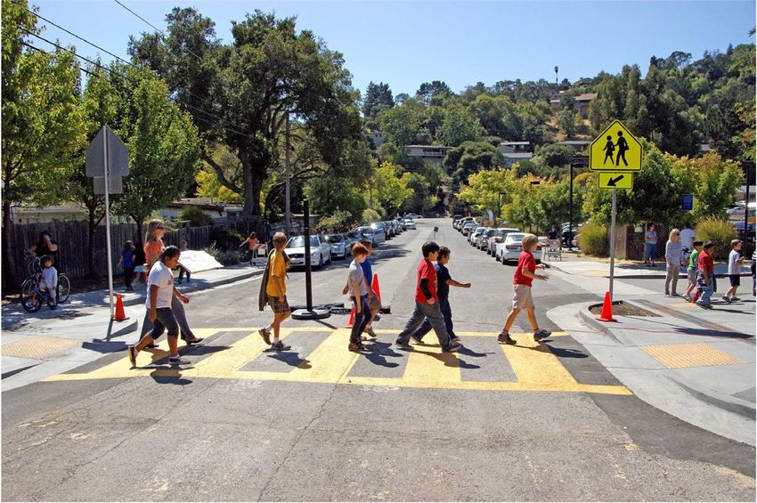
17COMPLETE STREET TREATMENTS
POTENTIAL COMPLETE STREETS OPPORTUNITIES
                                                      Universal Treatments:

                                                                                           Additional Treatments:
        Additional Treatments:                                                             Striping/visibility
        Implement the City’s lane                                                          improvements, raised
        configuration, with left turn                                                      markers
        signal ahead

                        Additional Treatment:                                 Additional Treatments:
                        Right in/right out at                                 Square up intersection, add
                        Monterey Market                                       median island to formalize
                                                                              turn restrictions

             Additional Treatment:
             Road diet

 Bulb-Out                 High-Visibility Crosswalk        Narrowed Lanes           Placemaking

 Bus Bulb-Out               Flashing Pedestrian           Transit Amenity           Gateway
                            Beacon                        Improvement               Treatment
                                                                                    (preliminary location)
HIGH VISIBILITY CROSSWALK
Benefits
• Makes pedestrians more visible to drivers
both before they enter the crosswalk and
while crossing
• May improve safety at the sites of
previous collisions or where vehicles tend
to speed, such as the crossing to the
track
What Is It? Notes
High visibility crosswalks • Can be implemented alongside any bike
facility
make pedestrians more
visible to drivers and alert
drivers to the potential of a
pedestrian.FLASHING PEDESTRIAN BEACON
Benefits
• Makes pedestrians more visible to drivers
both before they enter the crosswalk and
while crossing
• Improves yielding rates by drivers to
pedestrians in crosswalks
• May improve safety at the sites of
previous collisions or where vehicles tend
to speed, such as the crossing to the
track
What Is It? Notes
Pedestrian-activated • Can be implemented alongside any bike
facility
beacons alert vehicles to
the presence of pedestrians
in crosswalks.TRANSIT AMENITY IMPROVEMENT
Benefits
• Enhances transit user experience
• Increases comfort of people waiting for
transit service
• Lighting improves safety, especially at
night
What Is It? Notes
Addition of amenities at • Can be implemented alongside any bike
facility
transit stops such as
benches, shelters, trash • Shelters require 10’ sidewalk width
cans, and improved lightingNARROWED TRAVEL LANES
Benefits
• Slows speeds
• Reduces informal turn lanes at
intersections that may confuse drivers
and pedestrians, especially at all-way
stop signs such as the Monterey Avenue
intersection
What Is It? Notes
Narrowing lanes encourages • Can be implemented alongside any bike
facility
slowed speeds and prevents
informal turn lanes at
intersections that may confuse
users.BULB-OUTS
Benefits
• Improves visibility of pedestrians to
drivers
• Shortens pedestrian crossing distances
• Encourages slower vehicle speeds,
reducing collisions
• Slows the turning speeds of vehicles
What Is It? Notes
Bulb-outs extend the sidewalk into • May require removal of parking
the street. They can be installed
simply with paint and curb or • Design considerations when
constructed as actual extensions implementing on the same side of the
of the sidewalk. street as protected cycle tracks or bike
lanesBUS BULB
Benefits
• Helps bus travel times and reliability
• Provides more space for shelters and
other amenities
• Enhances transit user experience,
especially when paired with transit stop
amenities
What Is It? Notes
Curb extensions align the • Net increase in on-street parking
transit stop with the parking • Design considerations when
lane, allowing buses to stop implementing on the same side of the
without leaving the travel street as protected cycle tracks or bike
lanes
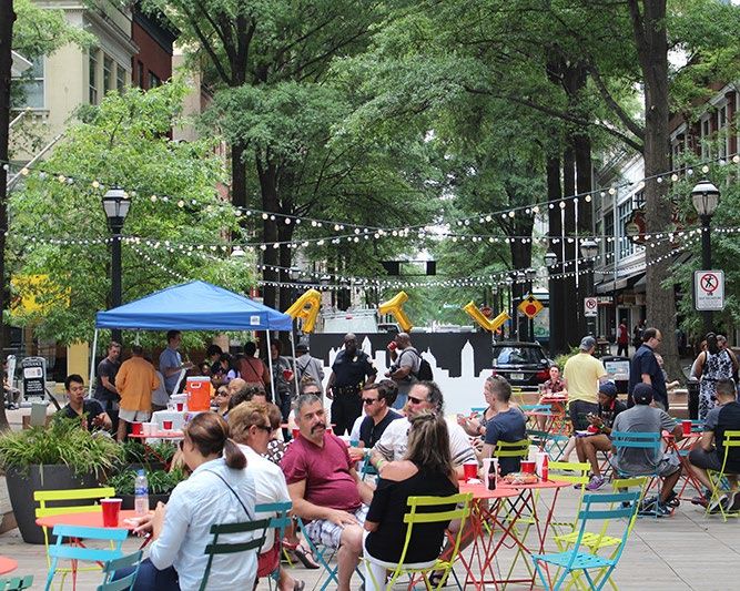
lane.PLACEMAKING
Benefits
• Provides public space for gatherings or
community events
• Enhances neighborhood character
What Is It? Notes
Placemaking uses various • Design considerations when
implementing on the same side of the
elements to create public street as protected cycle tracks or bike
spaces that promote lanes
community health and well-
being.GATEWAY TREATMENTS
Benefits
• Enhances neighborhood character
• Signals to drivers to reduce speeds and
be aware of the potential of pedestrians
and/or bicyclists in the roadway
Notes
• Requires adequate space to construct
What Is It? • Can be implemented alongside any bike
facility
Design elements mark the
transition to a neighborhood
or a street with a different
characteristic.BIKE LANE TREATMENTS
SEPARATED BIKEWAY

     Two-Way Protected   Raised

                                  40
BIKE LANE
Buffered
41NOTE: The preliminary corridor designs depicted in this presentation are conceptual
and subject to change pending public input and more detailed engineering studies. For
any of the three segments of Hopkins in this study, the option selected by the
community through the engagement process may ultimately be a fourth option as yet to
be identified through this engagement.
CORRIDOR DESIGN
OPTIONS43
Bike Lanes
OPTION 3:
Buffered
OPTION 2:
Separated
Bikeways
One-Way
OPTION 1:
Separated
Two-Way
Bikeway
NOTE: The preliminary corridor designs depicted in this presentation are conceptual and
subject to change pending public input and more detailed engineering studies. For any
of the three segments of Hopkins in this study, the option selected by the community
through the engagement process may ultimately be a fourth option as yet to be identified
through this engagement.NOTE: The preliminary corridor designs depicted in this presentation are conceptual
and subject to change pending public input and more detailed engineering studies. For
any of the three segments of Hopkins in this study, the option selected by the
community through the engagement process may ultimately be a fourth option as yet to
be identified through this engagement.
OPTION 1: TWO-WAY SEPARATED
BIKEWAY
View: looking west
Cross-Section Example (Between Sonoma Avenue and McGee Avenue)
44OPTION 1: TWO-WAY SEPARATED
BIKEWAY
• High level of bicycle safety
• 5% - 10% of on-street parking remains; metered parking
could be relocated to California St.
NOTE: The
• Pedestrians would cross bi-directional bicycle traffic to cross preliminary
the street corridor designs
depicted in this
• Reduction of buffer between moving cars and pedestrians on presentation are
north side of street conceptual and
subject to change
pending public
• High level of bicycle safety input and more
detailed
• Few driveways on south side of street enhances cyclist engineering
comfort studies. For any of
the three segments
• Pedestrians would cross bi-directional bicycle traffic to cross of Hopkins in this
the street study, the option
selected by the
• 35% - 40% of on-street parking remains community
through the
engagement
• High level of bicycle safety process may
ultimately be a
• Grade of street may result in large speed differential between fourth option as yet
uphill and downhill cyclists to be identified
through this
• Drivers using driveways will have to look for cyclists in both engagement.
directions
• 85% - 90% of on-street parking remains
45NOTE: The preliminary corridor designs depicted in this presentation are conceptual
and subject to change pending public input and more detailed engineering studies. For
any of the three segments of Hopkins in this study, the option selected by the
community through the engagement process may ultimately be a fourth option as yet to
be identified through this engagement.
OPTION 2: ONE-WAY SEPARATED
BIKEWAYS
View: looking west
Cross-Section Example (Between Sonoma Avenue and McGee Avenue)
46OPTION 2: ONE-WAY SEPARATED
BIKEWAYS
• High level of bicycle safety
• No on-street parking remains; metered parking could be
relocated to California St.
NOTE: The
• Design would be intuitive for most pedestrians preliminary
corridor designs
• Design suitable for all-ages and abilities depicted in this
presentation are
conceptual and
subject to change
pending public
• High level of bicycle safety input and more
detailed
• Few driveways on south side of street enhances cyclist engineering
comfort in uphill direction studies. For any of
the three segments
• Adequate space for bus bulbs on north side of street of Hopkins in this
• 35% - 40% of on-street parking remains study, the option
selected by the
community
through the
engagement
• Highest level of bicycle safety process may
ultimately be a
• Wide roadway width offers ability to provided desired design fourth option as yet
dimensions to be identified
through this
• 85% - 90% of on-street parking remains engagement.
47NOTE: The preliminary corridor designs depicted in this presentation are conceptual
and subject to change pending public input and more detailed engineering studies. For
any of the three segments of Hopkins in this study, the option selected by the
community through the engagement process may ultimately be a fourth option as yet to
be identified through this engagement.
OPTION 3: BUFFERED BIKE LANES
View: looking west
Cross-Section Example (Between Sonoma Avenue and McGee Avenue)
48OPTION 3: BUFFERED BIKE LANES
• Increased bicycle safety over existing conditions
• Conflicts between vehicles and cyclists would remain
• Anticipated that design wouldn’t attract as many cyclists NOTE: The
compared to other options preliminary
corridor designs
• Intuitive design for pedestrians depicted in this
• No on-street parking remains; metered parking could be presentation are
conceptual and
relocated to California St. subject to change
pending public
input and more
• Increased level of bicycle safety over existing conditions detailed
engineering
• Anticipated that design wouldn’t attract as many cyclists studies. For any of
compared to other options the three segments
of Hopkins in this
• Adequate space for bus bulbs on north side of street study, the option
selected by the
• 35% - 40% of on-street parking remains community
through the
engagement
process may
• Increased level of bicycle safety over existing conditions ultimately be a
fourth option as yet
• Less usage by cyclists compared to other options to be identified
through this
• 85% - 90% of on-street parking remains engagement.
49NOTE: The preliminary corridor designs depicted in this presentation are conceptual
and subject to change pending public input and more detailed engineering studies. For
any of the three segments of Hopkins in this study, the option selected by the
SUMMARY community through the engagement process may ultimately be a fourth option as yet to
be identified through this engagement.
Sutter St. – Sonoma Ave. Sonoma Ave. – McGee Ave. McGee Ave. – Gilman St.
Two-Way One-Way Buffered Two-Way One-Way Buffered Two-Way One-Way Buffered
Separated Separated Separated Separated Separated Separated
Pedestrian
Cyclists Pedestrians
Good Best Better Good Best Better Good Better Best
Comfort
Pedestrian
Good Best Better Good Best Better Better Better Better
Safety
Cyclist Comfort Better Best Good Best Better Good Better Best Good
Cyclist Safety Better Best Good Best Better Good Better Best Good
Parking 85%- 85%- 85%- 35%- 35%- 35%-
5-10% 0% 0%
Retention 90% 90% 90% 40% 40% 40%
Drivers
Vehicle
Operations Better Better Best Better Better Best Better Better Best
Preservation
Transit
Transit
Users
Operations N/A N/A N/A Good Better Better Good Better Better
Improvement
Cost & Ease of
$$ $$$ $ $$ $$$ $ $$ $$$ $
Implementation
50PLACEMAKING
COMMUNITY WORKSHOP #1 FEEDBACK On October 22, 2020, we held our first virtual community meeting where we took a poll that told us you are most interested in prioritizing the following placemaking elements: Sutter to Sonoma: Pedestrian Improvements, Landscape Enhancements, Gathering Spaces, Public Art Sonoma to McGee: Pedestrian Improvements, Landscape Enhancements, Public Art McGee to Gilman: Pedestrian Improvements, Landscape Enhancements, Gathering Spaces
PLACEMAKING TYPES
                                          Public Art/
Pedestrian     Landscape      Gathering   Gateway
Improvements   Improvements   Spaces      Elements

                                                        53
POTENTIAL PLACEMAKING LOCATIONS
Placemaking Gateway Treatment
Intersection and North
Intersection Entry to Parklet at
Cul de Sac at Entry to King Berkeley
at Gilman King Track Sutter St
Monterey Pool and park LibraryPOTENTIAL PLACEMAKING OPPORTUNITIES
Placemaking Gateway Treatment
Pedestrian Improvements Landscape Improvements Gathering Spaces Public Art Gateway TreatmentSMALL GROUP DISCUSSION
THANK YOU!
Contact Beth Thomas, Principal Planner
City of Berkeley, Transportation Division
with any questions or comments
BAThomas@cityofberkeley.info | (510) 981-7068
You can also read


