January 2021 BABY BROWN TIMBER SALE NSE - 1549 AMENDED BABY BROWN/GLACIER SIDE SALE NSE 1594 - State of Alaska Department of Natural Resources ...
←
→
Page content transcription
If your browser does not render page correctly, please read the page content below
State of Alaska
    Department of Natural Resources
           Division of Forestry
   Southeast Area - Haines State Forest

          Forest Land Use Plan
BABY BROWN TIMBER SALE NSE – 1549
          AMENDED
 BABY BROWN/GLACIER SIDE SALE
               NSE - 1594

            January 2021
Forest Land Use Plan for Baby Brown/Glacier Side Timber Sale (NSE – 1594)

  Table of Contents

I. Introduction ..................................................................................................................................... 4
       A. Legal Description ................................................................................................................ 4

        B. Operational Period ............................................................................................................... 5

        C. Timber Disposal .................................................................................................................. 5

        D. Objectives and Summary ..................................................................................................... 5

II. Affected Land Owners/Jurisdictions............................................................................................. 6
     A. State .................................................................................................................................. 6

        B.      Other Land Ownership ..................................................................................................... 6

III. Harvest Methods, Silvicultural Actions, and Management of Non-timber Resources ................ 6
      A. Timber Stand Description and History ............................................................................. 6

        B.      Timber Harvest Activities ................................................................................................ 7

        C.      Site Preparation ................................................................................................................ 7

        D.      Reforestation..................................................................................................................... 8

        E.      Slash Abatement ............................................................................................................... 9

        F.      Timber Harvest—Surface Water Protection ..................................................................... 9

        G.      Wildlife Habitat .............................................................................................................. 10

        H.      Cultural and Historical Resource Protection................................................................... 10

        I.      Other Resources Affected by Timber Harvest and Management ................................... 10

IV. Roads and Crossing Structures.................................................................................................. 11
     A. Road Design, Construction, and Maintenance................................................................ 11

        B.      Side Slopes / Mass Wasting............................................................................................ 13

        C.      Crossing Structures ......................................................................................................... 13

        D.      Road Closure .................................................................................................................. 16

        E.      Material Extraction ......................................................................................................... 17

        F.      Other Resources Affected by Roads or Material Extraction ........................................... 17
                                                                                                                                                     2
Forest Land Use Plan for Baby Brown/Glacier Side Timber Sale (NSE – 1594)
V. Approvals ................................................................................................................................... 18
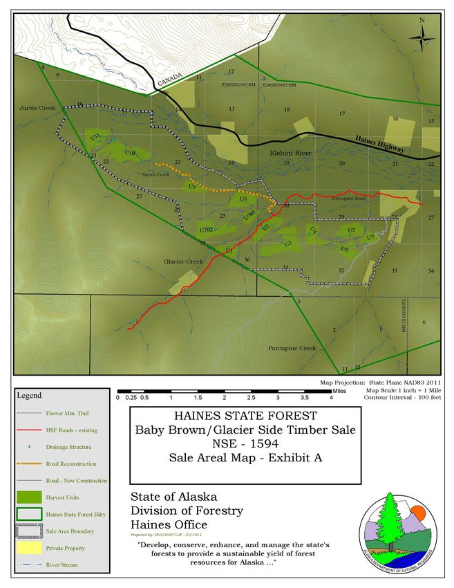
Appendix A: Timber Sale Maps ...................................................................................................... 19
Exhibit A1: Sale Area......................................................................................................... 20
Exhibit A2: Unit Harvest Detail (10 Maps – 13 Units) ................................ attached page 21
Appendix B: Supporting Information............................................................................................... 20
B1: Silvicultural/Timber Stand Information....................................................................... 20
B2: DOF Standards ............................................................................................................. 22
B3: Required Permits .......................................................................................................... 22
Appendix C: Appeal Statutes and Regulations.......................................See Original Sale Documents
Appendix D: Public and Agency Comments and Responses .................See Original Sale Documents
Fish and Wildlife Habitat ..............................................................See Original Sale Documents
Timber Sale Support/Opposition ...................................................See Original Sale Documents
Tourism .........................................................................................See Original Sale Documents
Silviculture/ Harvest Methods .......................................................See Original Sale Documents
Visuals ...........................................................................................See Original Sale Documents
Economics .....................................................................................See Original Sale Documents
Public Notice and Input .................................................................See Original Sale Documents
3Forest Land Use Plan for Baby Brown/Glacier Side Timber Sale (NSE – 1594)
I. Introduction
Project File Number: NSE - 1594
Division of Forestry Office: Haines
Haines Forester: Gregory J Palmieri
Forest Practices Geographic Region (AS 41.17.950): One
This Forest Land Use Plan (FLUP) describes proposed forest operations on approximately 1006
acres of land in the Haines State Forest some 37 miles northwest of Haines. It is intended to
provide the best available information regarding the proposed harvest of timber, and management
of other non-timber resources in compliance with AS 38.05.112 and AS 41.17.060.
This amended FLUP is for a timber sale which has been determined to be in the best interest of
the State pursuant to AS 38.05.035 (e) and 38.05.945; Best Interest Finding (BIF), Baby Brown
Timber Sale/NSE – 1549, March 15, 2015 and BIF/FLUP for the Glacier Side 2 Timber Sale/SE-
717-H, March 16, 2006. The revised FLUP for the Baby Brown Timber Sale was adopted by the
commissioner on February 15, 2018. The final decision BIF/FLUP for the Glacier Side 2 Timber
Sale was signed March 16, 2006.
The prior public record for these two sales is kept in their respective files at the Haines DOF
office.
This amended FLUP represents the combination of Glacier Side 2 with Baby Brown to offer as one
sale. Combining these two sales into a single sale offering is consistent with the original intent of
the timber sale and the agency/public review process that have been completed and does not alter
the sales. The function of this document is to centralize the operational information for the purpose
of clarity to aid the administration of the project.
This timber sale is designed to be consistent with the management intent of the following
documents:
Haines State Forest Management Plan (Rev. 2002)
Chilkat Bald Eagle Preserve Management Plan (Rev. 2002)
Northern Southeast Area Plan (2002)
The administrative record for this sale is maintained at the Division of Forestry Southeast Area,
Haines State Forest Office filed as NSE - 1594.
A. Legal Description (see also map in Appendix A): This proposed sale is found within
portions of Sections 14, 15, 16, 21, 22, 23, 24, 25, 26, 27, & 36 within Township 28 South Range
53 East, and portions of Sections 19, 28, 29, 30, 31, 32, & 33 Township 28 South Range 54 East,
Copper River Meridian. The USGS quadrangle map for this area is Skagway B4, 1:63,360.
4Forest Land Use Plan for Baby Brown/Glacier Side Timber Sale (NSE – 1594)
B. Operational Period May 2021 to December 2026.
C. Timber Disposal
Timber will be sold and will have a contract administrated by the State.
D. Objectives and Summary
1. To follow the Department of Natural Resources (DNR) constitutional mandate to encourage the
development of the State’s renewable resources, making them available for maximum use consistent
with the public interest. Sustain and promote a healthy, long-term timber industry in the state, through
providing a secure source of timber for harvest while protecting other resources such as fish and
wildlife.
2. To help the State’s economy by providing royalties to the state in the form of stumpage receipts, as
well as contributions to local economies through wages, purchases, jobs and business.
3. To improve forest growth and vigor by harvesting and replacing mature or over mature forest
stands with regenerating stands, while protecting and maintaining other resource values. The actions
authorized under this decision will follow the constitutional mandate of sustained yield and shall
adhere to multiple use management as described in the Haines State Forest Management Plan
(HSFMP).
4. The sale will provide road maintenance and repair which will provide continued recreation use.
5Forest Land Use Plan for Baby Brown/Glacier Side Timber Sale (NSE – 1594)
II. Affected Land Owners/Jurisdictions
Written
Representative
Activity on ownership: Access Harvest Approval
A. State
[X] Haines State Forest [ ] [X] [X]
[ ] Other state land managed by DNR [ ] [ ] [ ]
[ ] University of Alaska [ ] [ ] [ ]
[ ] Mental Health Trust [ ] [ ] [ ]
[ ] School Trust [ ] [ ] [ ]
B. Other Land Ownership [ ] [ ] [ ]
Land Owner: _________________________________________________
Land Owner Representative: ___________________________________
III. Harvest Methods, Silvicultural Actions, and Management of Non-timber
Resources
Forest operations will be designed to:
• Protect fish habitat and water quality in compliance with the best management practices in
11 AAC 95.260-.370,
• Manage for the other land uses and activities identified in AS 41.17.060 and the Best
Interest Finding for this timber sale, and
• Result in the sustained yield of timber and maintenance of site productivity in compliance
with AS 41.17.060(c) and 11 AAC 95 .375-.390.
Harvest and Silvicultural Methods:
The harvest and silvicultural methods are attached to this document in Appendix B.
A. Timber Stand Description and History
The timber is predominately composed of mature and over mature Hemlock/Spruce stands on
productive sites within the Haines State Forest. The acres in this sale area have been identified as
available for timber harvest as a primary use in the Haines State Forest Management Plan.
Historically, some stands between Glacier and Porcupine Creeks in the sale area were harvested in
the early 1900’s as a result of development to support mining activity in that area. The harvest
units addressed in this FLUP have timber ranging from 100 to 250 years old (HSF Inventories,
1965/1985/2012).
6Forest Land Use Plan for Baby Brown/Glacier Side NSE - 1594
B. Timber Harvest Activities
Timber Harvest Activities are displayed in Table 1.
Table 1. Timber Harvest Activities
Unit ID Acres Topography Silvicultural Action Logging Method
01 52 Broken CC/Partial Ground-based/Cable
Hillside/Flat Areas
02 79 Broken Hillside CC/Partial Ground-based/Cable
03 140 Flat Ridge CC/Partial Ground-based/Cable
Top/Hillside
04 65 Ridge Top/Hillside CC/Partial Ground-based/Cable
05 69 Broken Hillside CC/Partial Ground-based/Cable
06 61 Broken Hillside CC/Partial Ground-based/Cable
07 34 Hillside Clear Cut Cable
08 76 Hillside CC/Partial Ground-based/Cable
09 45 Hillside Clear Cut Cable
10 149 Broken CC/Partial Ground-based
Hillside/Flat Areas
11 86 Broken Hillside CC/Partial Cable
701 39 Broken Hillside CC/Partial Ground-based/Cable
702 112 Broken Hillside CC/Partial Ground-based/Cable
CC= Clear Cut
C. Site Preparation
Site preparation is a performance requirement of the logging contract. A separate site
preparation will not be generally necessary in areas with sufficient soil disturbance by logging
during the summer and in areas with sufficient residual stocking. If logging activity continues
into winter months when more than 12 inches of snow coverage occurs across a harvest unit,
subsequent scarification will be required in the absence of snow and frozen conditions. In the
case that site preparation is required due to winter logging, the specification for that activity
will be addressed in the Purchaser’s Operating Plan.
[ ] Site preparation will be implemented and described in Table 2:
7Forest Land Use Plan for Baby Brown/Glacier Side NSE - 1594
Table 2. Site Preparation
Unit Acres Site Preparation Method Date of Completion
D. Reforestation
[X] Clear Cut
[X] Partial Harvest:
[ ] Region I: leaving more than 50% live basal area (11 AAC 95(b)(3))
[ ] Region II/III: Relying on residual trees to result in a stocking level that meets
standards of 11 AAC 95.375 (b 4). Stocking levels will be calculated subject to the methods
below:
Table 3. Stocking Level Requirements
Average DBH Residual Minimum Stocking Percent
(Diameter at Trees (Trees / Standard (Trees/ acre) Stocking
breast height) acre)
> 9” 120 %
6” to 8” 170 %
1” to 5” 200 %
Total Residual Stocking %
Seedlings Required:
Percentage Under stocked = 100 – Total Residual Stocking %
Percentage Under stocked = 100 – %= %
Seedlings/ Acre Required = Percentage Understocked/100 x 450
Seedlings/ Acre Required = % /100 x 450 =
[X] Natural regeneration
Reforestation requirements for these harvest units will be met through natural
regeneration of Sitka Spruce and Western Hemlock. Based on prior harvest experience
in the adjacent areas, reforestation meeting Region 1 standards is projected to naturally
occur. If after five years from harvest completion these standards are found not to be
successfully met, the DOF will initiate a planting program to ensure restocking
requirements are met in a timely manner.
8Forest Land Use Plan for Baby Brown/Glacier Side NSE - 1594
E. Slash Abatement
Potential for insect infestations caused by slash accumulations exists as harvest debris piles
could provide available hosting material for Spruce bark beetles (Dendroctonus rufipennis)
identified as damaging to live trees when present in high numbers. Slash abatement for
controlling infestations will be implemented as required by 11AAC 95.370.
Lop and scatter slash from Sitka Spruce trees harvested; accumulations will be kept to less
than 3 feet in height.
F. Timber Harvest—Surface Water Protection
There are no known anadromous classified streams in the harvest units or within 300 feet of
the harvest units addressed in this FLUP.
[ ] There are no streams or lakes abutting or within a harvest unit.
[X] Known surface waters and protection measures are described in Table 4 below.
Locations are included in the operational map in the Appendices
Table 4. Protection for Known Surface Waters
AS Required
Site-specific actions to minimize
Waterbody 41.17.950 ADF&G Riparian
impacts on riparian area
Unit Name Classification AWC # Protection
Implement FRPA and Regulations,
including actions such as: full
suspension, split yarding, directional
falling, will not buck or limb in or
Non- over surface waters, clear logging
classified slash in surface waters as yarding
All All None None
surface occurs, minimize the introduction of
waters logging debris in and adjacent to
waters through preplanning with the
purchaser, coordinate cutting
activity, and ensure operator is aware
of surface water location.
1/8/10/ Several and Tributary to Directional Site specific logging plan by
None
11/701 Unnamed Anadromous falling purchaser approved by DOF*
*The site specific operating plan will have as its prime objective the maintenance of existing
water quality by retaining bank stability and, to the maximum extent feasible, the avoidance of
instream activity to minimize the introduction of soil, debris, slash and petroleum products
directly and indirectly into the classified waters.
Surface waters were reviewed by the Department of Fish and Game:
[X] During the timber sale planning process
[X] During the agency review conducted for the Best Interest Finding for this sale
[X] During the drafting of this Forest Land Use Plan
[ ] Stream Crossings (Title 16) Permits are needed per ADF&G Division of Habitat
9Forest Land Use Plan for Baby Brown/Glacier Side NSE - 1594
Surface waters listed were reviewed by the Department of Environmental Conservation:
[ ] During the timber sale planning process
[X] During the agency review conducted for the Best Interest Finding for this sale
[X] During the drafting of this Forest Land Use Plan
Non-classified surface waters are subject to applicable BMPs in 11 AAC 95.
G. Wildlife Habitat
[ ] Wildlife species and allowances for their important habitats were addressed in writing by the
Department of Fish & Game during the Best Interest Finding review.
[X] Wildlife species and allowances for their important habitats were addressed in writing by the
Department of Fish & Game during the drafting of this Forest Land Use Plan.
Silvicultural practices to be applied to minimize impacts to wildlife habitat or wildlife management:
[X] Timber retention - concentrations of timber surrounding harvest units, or interspersed
within harvest units will provide cover.
[X] Snag Retention- snags or isolated trees left for cavity nesting species.
[ ] Large Woody Debris – concentrations of downed timber or logging debris interspersed
within harvest units to provide cover left on site.
[ ] Other actions
H. Cultural and Historical Resource Protection
[X] This project was reviewed by the State Historic and Preservation Office (SHPO).
[X] No artifacts have been reported within the project area(s).
[ ] Known or likely sites have been identified and a mitigation plan is in place. (Describe
the mitigation actions.)
I. Other Resources Affected by Timber Harvest and Management
During the Public Review Process of the Baby Brown timber sale Preliminary BIF the DOF
received comments referring to the possible view of harvest areas from the Haines
Highway. Taking public comment into consideration during the preparation of the BIF a
visibility analysis from three observation points along the Haines Highway concluded that
approximately 80% of the proposed harvest areas would be visible from those positions.
This FLUP presents the final design of the harvest units including a harvest plan that further
considers the scenic impacts from the same three observation points along the Haines
Highway.
The new analysis of the potential view of all the harvest units designed in this sale
concludes that no more than 64% of harvest activities would be visible from any of the
three observation points along the Haines Highway.
The harvest plan designed for this sale combines clear cutting with selective harvest of
10Forest Land Use Plan for Baby Brown/Glacier Side NSE - 1594
timber that will additionally contribute to the reduction of the visibility of harvest activity
from the Haines Highway viewpoints.
The DOF has reviewed the Alaska Department of Transportation planning documents for
the Haines Highway improvement project, the Haines Borough Comprehensive Plan, and
the Haines Highway Corridor Cooperative Management Plan for identification of scenic
value related to the Haines Highway corridor and the potential impacts from the proposed
timber harvest on the Haines Highway view shed. The DOF harvest plan prepared for this
sale represents a strategic effort to diminish the potential for harvest activities to be visible
from the Haines Highway according to the management guidelines and intent described in
the Haines State Forest Management Plan (rev. 2002).
Table 5. Other Affected Resources/ Areas of Concern.
Impacted Resource Reviewing Agency Impact/ Mitigation Actions
Scenic DOF Retention of standing trees in units and
distribution of remaining timber around
designated units.
IV. Roads and Crossing Structures
A. Road Design, Construction, and Maintenance
Roads will be designed, constructed, and maintained to prevent significant adverse impacts on
water quality and fish habitat (AS 41.17.060(b) (5)), and site productivity (AS 41.17.060(c) (5)).
Roads will comply with the best management practices in the Forest Resources and Practices
Regulations (11 AAC 95.285 – 95.335)
Road construction will follow guidelines described in the contract and HSFMP. Region One
forest road construction standards will be used (See Appendix B2).
Roads or other means required for the access and removal of this timber from the harvest areas or
units are listed in Table 6.
Table 6. Road Construction and Use
Harvest Road Maximum Constructed
Road ID Unit Road Miles Type Grade by Maintained by
Main Haul Units Glacier Creek Primary 5% Installed by Purchaser
“Porcupine 701/702/8/9/ crossing Purchaser
Road” 10/11 structure (60ft
MSB)
11Forest Land Use Plan for Baby Brown/Glacier Side NSE - 1594
Harvest Road Maximum Constructed
Road ID Unit Road Miles Type Grade by Maintained by
Main Haul Unit 1 1.25 Primary 10% Existing Purchaser
“East Glacier
Creek Road” Constantine Metals
Spur A Unit 1 0.3 Spur 10% Purchaser Purchaser
Main Haul Unit 2 - 5 2.76 Spur 15% Purchaser Purchaser
1100 Road
Spur 1110 Unit 2 0.06 Spur 5% Purchaser Purchaser
Spur 1120 Unit 3 0.4 Spur 12% Purchaser Purchaser
Main Haul Unit 6 - 7 0.94 Spur 10% Purchaser Purchaser
1200 Road
Spur 1210 Unit 6 0.09 Spur 15% Purchaser Purchaser
Main Haul Unit 8 - 9 2.64 Primary 5% Purchaser Purchaser
Reconstructio
n
1400 Road
Spur 1305 Unit 8 0.59 Spur 15% Purchaser Purchaser
Spur 1410 Unit 9 0.13 Spur 12% Purchaser Purchaser
Main Haul Unit 10 – 1.39 Primary 10% Purchaser Purchaser
11
1400 Road
Spur 1420 Unit 10 0.3 Spur 10% Purchaser Purchaser
Spur 1430 Unit 11 0.55 Spur 12% Purchaser Purchaser
Main Haul Unit 701- 1.45 Primary 12% Purchaser Purchaser
1405 Road 702
*Note: Roads must be less than 20% grade per 8 AAC 61.1060 Additional Logging
Standards
*Note: Maximum road grade shall be based on DOF road class unless otherwise
specified.
12Forest Land Use Plan for Baby Brown/Glacier Side NSE - 1594
B. Side Slopes / Mass Wasting
For slopes over 50%, identify indicators of unstable areas (landslide scars, jack-straw trees,
gullied or dissected slopes, high density of streams or zero-order basins, or evidence of soil
creep. Attach location specific road design that potentially mitigates identified areas of
unstable soils.
Maximum percent side slopes: 67%
[ ] There are no slopes >50%
[ ] There are no indicators of unstable areas where roads will be constructed
[ X ] Indicators of unstable areas were identified and will be mitigated by actions indicated
below.
[ X ] Full benching will be constructed to help ensure slope stability
[ ] Full benching is not required for roads in this project
[ X ] End hauling will be implemented to help ensure slope stability
[ ] End hauling is not necessary for roads in this project.
Gullied/dissected slopes greater than 50% were located along the Main Haul Road construction
between Unit 3 and Unit 4 from station 87+52 to 92+32. Full Bench construction with end
haul of excavated material will be required through this 480-foot section to maintain slope
stability.
Are you removing or replacing drainage structures? [ X] YES [ ] NO
Two drainage structures are scheduled to be replaced along the reconstructed segment of road
west of Glacier Creek required in this sale. The first drainage structure replaces a 20’ log bridge
at station 52+40 and the second replaces a 40’ log bridge at station 102+08 respectively along the
segment.
General Erosion Control:
[ X ] grass seeding [ ] erosion control mats [ ] wattle [X] Other: Water bars and out
sloping of spur roads
[ ] not applicable
C. Crossing Structures
[ ] No crossing structures are needed within the project area.
[X] Crossing structures will be placed along access roads as described in the table below:
13Forest Land Use Plan for Baby Brown/Glacier Side NSE - 1594
Table 7. Required Drainage and Crossing Structures on Known Surface Waters
Bridge Type: AS Duration of
-Log Stringer 41.17.950 crossing
Mile / Diameter -Fabricated Stream Road structure in
Road Station Culvert -Ice Classification POB/length place
Porcupine Glacier
60ft MSB
Creek Unclassified Permanent
U–1 45+95 Setting
Spur A 11+42 18” Ditch Relief EGlacier/.3mi Access
U2 –U5
Main Haul 16+00 Permanent
1100Rd 0+00 18” Ditch Relief EGlacier/2.76mi (all)
3+20 18” Unclassified
13+78 18” Unclassified
47+48 18” Ditch Relief
56+32 18” Ditch Relief
68+40 18” Ditch Relief
96+70 18” Ditch Relief
106+62 18” Unclassified
116+76 18” Unclassified
128+60 18” Unclassified
140+20 18” Ditch Relief
U3 Spur 63+14 Setting
1120Rd 14+00 18” Ditch Relief 1100Rd/.4mi Access
U6–U7
Main Haul 119+35 Permanent
1200Rd 6+18 60” Unclassified 1100Rd/.9mi (all)
13+17 18” Ditch Relief
18+60 18” Ditch Relief
35+30 18” Ditch Relief
43+15 18” Ditch Relief
14Forest Land Use Plan for Baby Brown/Glacier Side NSE - 1594
Bridge Type: AS Duration of
-Log Stringer 41.17.950 crossing
Mile / Diameter -Fabricated Stream Road structure in
Road Station Culvert -Ice Classification POB/length place
U8-U9
Main Haul
Reconst. Glacier Permanent
1400Rd 25+72 18” Ditch Relief Creek/2.8mi (all)
42+90 18” Ditch Relief
Replace –
52+40 60” Log Culvert Unclassified
91+42 18” Ditch Relief
Replace - 40’
102+08 Bridge Type I-D
U8 Spur 17+71 Setting
1305Rd 14+20 18” Unclassified WGlacier/.6mi Access
U10-U11 147+84
Main Haul EndReconstruct Permanent
1400Rd 15+25 36” Unclassified 1400/1.4mi (all)
21+14 36” Unclassified
26+12 18” Unclassified
36+92 18” Ditch Relief
50+48 18” Unclassified
53+60 60” Unclassified
58+89 18” Unclassified
63+40 18” Unclassified
69+45 18” Unclassified
15Forest Land Use Plan for Baby Brown/Glacier Side NSE - 1594
Bridge Type: AS Duration of
-Log Stringer 41.17.950 crossing
Mile / Diameter -Fabricated Stream Road structure in
Road Station Culvert -Ice Classification POB/length place
U10 Spur 22+35 New Setting
1420Rd 4+25 18” Unclassified Constr 1400/.3mi Access
Setting
12+62 18” Unclassified Access
U11 Spur 39+43 New Setting
1430Rd 9+64 18” Unclassified Constr/.6mi Access
Setting
13+32 60” Unclassified Access
Setting
24+16 24” Unclassified Access
U701 702
Main Haul 5+33 Reconstr
1405Rd 7+58 18” Unclassified 1400rd/1.4mi Permanent
60’ Log
stringer Setting/Unit
20+40 bridge Unclassified Access
Setting
22+87 18” Unclassified Access
Setting
31+67 18” Unclassified Access
Setting
42+84 18” Unclassified Access
Setting
62+63 18” Unclassified Access
Setting
67+30 18” Unclassified Access
Setting
69+10 24” Unclassified Access
D. Road Closure
Roads constructed for the timber sale that are left open will be subject to maintenance standards
under 11 AAC 95.315. Otherwise, roads constructed for the timber sale will be closed, subject to
standards under 11 AAC 95.320.
16Forest Land Use Plan for Baby Brown/Glacier Side NSE - 1594
Table 8. Road Closures
Road ID Units All Estimated Closure Projected Road Use after Timber
Season/Winter Date Harvest
Main Haul 1 – 11, All season None Silviculture
701/702
Spurs All All season At completion of Silviculture
harvest or
December 2025
E. Material Extraction
[ ] There will be no material extraction sites in the project area.
[X] Material extraction for road construction and associated overburden disposal will be located
outside of riparian areas and muskegs except as approved in the Glacier Creek flood plain.
Material extraction and disposal sites will be located by the purchaser operating plan, in a manner
that prevents runoff from entering surface waters and will be approved by DOF prior to use.
Material sites will be incidental and adjacent to the road construction. Pit sites are projected to be
less than one acre and will be stabilized upon completion of road building operations.
[ X ] Other: The flood plain of Glacier Creek adjacent to the bridge crossing site is designated as
a material source location for road construction. Material extraction from this area will follow
DOF specifications as approved by ADF&G.
F. Other Resources Affected by Roads or Material Extraction
List resources other than water, habitat or cultural resources potentially impacted by road
construction, and indicate how impacts will be mitigated. Other affected resources could be, but
are not limited to mining claims, scenic areas, recreational trails, etc.
Table 9. Other Affected Resources
Impacted Resource Reviewing Agency Impact/ Mitigation Actions
Scenic DOF Location and Design
The DOF has identified road locations for the harvest of timber throughout this sale with
consideration of potential visual impacts from the Haines Highway. The majority of harvest road
related activity will be shielded from view by remaining standing timber not included in this sale.
The harvest design will further reduce the visibility of road development from the Haines
Highway.
17Forest Land Use Plan for Baby Brown/Glacier Side NSE - 1594
V. Approvals
This Final Forest Land Use Plan has been reviewed by the Division of Forestry and provides
the information necessary to be adopted by the Department of Natural Resources as
required by 38.05.112.
________________________________ __________________________
Area Forester Date
Greg Digitally signed by Greg
Staunton
Staunton Date: 2021.02.01
15:02:23 -09'00'
18Forest Land Use Plan for Baby Brown/Glacier Side NSE - 1594
Appendix A: Timber Sale Maps
198
12
Ü
9 D A 11
NA 7
CA T28SR53ECRM T28SR54ECRM
16
Jarvis Creek 14 13 18
15 17
16 15
Y 1X
U1X Hain
es H
X YXY X
YX
ighw
Y YX
X Y
Y
a y
X
Y
YU Y
21
X
10X
YX
Y
X
Klehini River
22 Y
X 23 24 19 20 21 22
Sarah Creek
Y
X
U9 Y
X
Y
X
27
Y
X
U8 Porcupine Road
Y
X
30
26 X
Y
01
Y
X
25
U7 29 28 27
Y
X YX
XY
Y
X
Y2
X
Y
U70X2X U U5
YX
X Y
X
YX
Y Y
U4
U7
Y
X Y
X Y
X Y
X
Y
X
35 U3
Y
X X
Y
Y
X Y
X
XU6
Y Y
X Y
X
U1
Y
X X Y Y
X
Glacier Creek 36
31
32 33 34
3
T29SR54ECRM
6
2 1
Porcupine Creek
11 12
Map Projection: State Plane NAD83 2011
Map Scale:1 inch = 1 Mile
Legend
Miles
0 0.25 0.5 1 1.5 2 2.5 3 3.5 4 Contour Interval - 100 feet
Flower Mtn. Trail
HAINES STATE FOREST
HSF Roads - existing Baby Brown/Glacier Side Timber Sale
Drainage Structure NSE - 1594
Sale Areal Map - Exhibit A
Y
X
Road Reconstruction
Road - New Construction
Harvest Units State of Alaska
Haines State Forest Bdry Division of Forestry
Sale Area Boundary
Haines Office
Prepared by: HNS/DOF/GJP - 01/2021
Private Property "Develop, conserve, enhance, and manage the state's
forests to provide a sustainable yield of forest
! ! ! !
River/Stream resources for Alaska ..."Ü
Glacier Creek
25
95
+
45
r A
Spu
"
18
2_
+4
11
Y
X
36
U1
Map Projection: State Plane NAD83 2011
Legend Feet Map Scale:1 inch = 330 feet
0 330 660 1,320 Contour Interval - 25 feet
Haines State Forest Bdry
HAINES STATE FOREST
Baby Brown/Glacier Side Timber Sale
Harvest Units
NSE - 1594
Logging Method
Harvest System Design
Ground
Harvest Detail Map - Exhibit A1
Unit 1
Cable
HSF Roads - existing State of Alaska
Road Reconstruction Division of Forestry
Road - New Construction
Haines Office
Prepared by: HNS/DOF/GJP - 01/2021
Drainage Structure "Develop, conserve, enhance, and manage the state's
forests to provide a sustainable yield of forest
Y
X
! ! ! !
River/Stream resources for Alaska ..."Y
X
Ü
d
5R
Y
X
0
14
U701
Glacier Creek
00
"
18
+
38
8_
16
+
+7
Y
X
16
13
8" Y
X
_1
8"
d
20
_1
11 00 R
3+
44
Y
X
25 6+
U2
X
Y
30
"
18
0_
+4
68
Y
X
14
"
18
+
2_
63
+3
"
1120 Rd
18
56
8_
Y
X
+4
47
Y
X
Y
X
U3
36 31
Map Projection: State Plane NAD83 2011
Legend Feet Map Scale:1 inch = 660 feet
0 330 660 1,320 1,980 2,640 Contour Interval - 25 feet
Haines State Forest Bdry
HAINES STATE FOREST
Baby Brown/Glacier Side Timber Sale
Harvest Units
NSE - 1594
Logging Method
Harvest System Design
Ground
Harvest Detail Map - Exhibit A2
Units 2 & 3
Cable
HSF Roads - existing State of Alaska
Road Reconstruction Division of Forestry
Road - New Construction
Haines Office
Prepared by: HNS/DOF/GJP - 01/2021
Drainage Structure "Develop, conserve, enhance, and manage the state's
forests to provide a sustainable yield of forest
Y
X
! ! ! !
River/Stream resources for Alaska ..."Ü
30 29
U4
U5
"
18
10
0_
6+
+7
62
96
_1
Y
X 1100 Rd
8"
Y
X
12
8"
8+
_1
60
Full Bench
76
_1
8"
6+
End Haul Required Y
X
11
35
Y
X
9+
11
U3
120
Y
X
0 Rd
"
18
0_
Y
X
+6
18
Y
X
U6
31 32
Map Projection: State Plane NAD83 2011
Feet Map Scale:1 inch = 660 feet
0 330 660 1,320 1,980 2,640 Contour Interval - 25 feet
Legend
HAINES STATE FOREST
Baby Brown/Glacier Side Timber Sale
Sale Area Boundary
Harvest Units
NSE - 1594
Logging Method
Harvest Detail Map - Exhibit A3
Unit 4
Harvest System Design
Ground
Cable State of Alaska
HSF Roads - existing Division of Forestry
Road - New Construction
Haines Office
Prepared by: HNS/DOF/GJP - 01/2021
Drainage Structure "Develop, conserve, enhance, and manage the state's
forests to provide a sustainable yield of forest
Y
X
! ! ! !
River/Stream resources for Alaska ..."Ü
29 U5 28
8"
_1
20
0+
14
Y
X 1100 Rd
12
8"
8+
_1
60
76
_1
U7
8"
6+
Y
X
11
35
Y
X
9+
11
U4
"
18
0_
Y
X
120
Y
X
+3
0 Rd
35
"
Y
X
18
50
0_
Y
X
+6
+
23
18
Y
X
1210 R
d
U6
32 33
Map Projection: State Plane NAD83 2011
Legend Feet Map Scale:1 inch = 660 feet
0 330 660 1,320 1,980 2,640 Contour Interval - 25 feet
Sale Area Boundary
HAINES STATE FOREST
Baby Brown/Glacier Side Timber Sale
Harvest Units
NSE - 1594
Logging Method
Harvest System Design
Ground
Harvest Detail Map - Exhibit A4
Units 5, 6, & 7
Cable
HSF Roads - existing State of Alaska
Road - New Construction Division of Forestry
Y
X Drainage Structure
Haines Office
Prepared by: HNS/DOF/GJP - 01/2021
Flower Mtn. Trail "Develop, conserve, enhance, and manage the state's
forests to provide a sustainable yield of forest
! ! ! !
River/Stream resources for Alaska ..."10
Ü
2+
08
_4
0f
tB
rd
g
à
Y
X
40ft MSB
Install
Sarah Creek
23 24
"
18
17
2_
+
+4
92
91
Y
X
1410 Rd
U9
26 25
Map Projection: State Plane NAD83 2011
Legend Feet Map Scale:1 inch = 330 feet
0 330 660 1,320 Contour Interval - 25 feet
Sale Area Boundary
HAINES STATE FOREST
Baby Brown/Glacier Side Timber Sale
Harvest Units
NSE - 1594
Logging Method
Harvest System Design
Ground
Harvest Detail Map - Exhibit A7
Unit 9
Cable
HSF Roads - existing State of Alaska
Road Reconstruction Division of Forestry
Road - New Construction
Haines Office
Prepared by: HNS/DOF/GJP - 01/2021
Drainage Structure "Develop, conserve, enhance, and manage the state's
forests to provide a sustainable yield of forest
Y
X
! ! ! !
River/Stream resources for Alaska ..."Ü
16 15 14
"
18
"
5_
18
+4
0_
69
+4
"
18
Y
X 24 63
U11
8_
Y
X
"
+4
"
Y
X
60
Y
X
50
2_
6_
1400
X
Y
+3
+1
R d
13
24
24
1430 Rd
Y
X Y
X
"
+
Y
X
18
40
2_
+9
36
Y
X
21
12
+6
2_
8"
18
_1
"
Y
X
U10
25
Y
X
55
4+
X1
420
Y
+
Rd
22
Y
X
22 23
Y
X
14
7
+8
4
Map Projection: State Plane NAD83 2011
Legend Feet Map Scale:1 inch = 1000 feet
0 330 660 1,320 1,980 2,640 3,300 3,960 Contour Interval - 25 feet
Sale Area Boundary
HAINES STATE FOREST
Baby Brown/Glacier Side Timber Sale
Harvest Units
NSE - 1594
Logging Method
Harvest System Design
Ground
Harvest Detail Map - Exhibit A8
Units 10 & 11
Cable
HSF Roads - existing State of Alaska
Road Reconstruction Division of Forestry
Road - New Construction
Haines Office
Prepared by: HNS/DOF/GJP - 01/2021
Drainage Structure "Develop, conserve, enhance, and manage the state's
forests to provide a sustainable yield of forest
Y
X
! ! ! !
River/Stream resources for Alaska ..."Ü
24 19
"
60
0_
+4
"
18
52
0_
Y
X
+9
42
Y
X
"
18
2_
+7
25
Y
X
U8
1305 Rd
8"
_1
58
Y
X
7+
3 3
Y
X
5+
25
71
30
+
17
"
18
60ft MSB
7_
Install
Y
X
à
+8
22
"
18
Y
X
7_
+6
1405 Rd
31
Y
X
U701 Glacier Creek
"
18
4_
+8
42
Y
X
00
"
18
+
38
8_
16
+
+7
Y
X
16
13
8" Y
X
_1
8"
U2 d
20
_1
11 00 R
3+
44
Y
X
6+
Y
X
U702
Map Projection: State Plane NAD83 2011
Legend Feet Map Scale:1 inch = 660 feet
0 330 660 1,320 1,980 2,640 Contour Interval - 25 feet
Sale Area Boundary
HAINES STATE FOREST
Baby Brown/Glacier Side Timber Sale
Harvest Units
NSE - 1594
Logging Method
Harvest System Design
Ground
Harvest Detail Map - Exhibit A5
Units 701 & 8
Cable
HSF Roads - existing State of Alaska
Road Reconstruction Division of Forestry
Road - New Construction
Haines Office
Prepared by: HNS/DOF/GJP - 01/2021
Drainage Structure "Develop, conserve, enhance, and manage the state's
forests to provide a sustainable yield of forest
Y
X
! ! ! !
River/Stream resources for Alaska ..."Ü
Y
X
"
18
4_
+8
42
Y
X
26
25
"
"
24
18
27
0_
0_
64
+1
+3
+
+
61
69
U702 67
91
1405
Y RdX
X Y Y
X
Glacier Creek
95
35
+
45
r A
Spu
"
18
2_
36 +4
11
Y
X
U1
Map Projection: State Plane NAD83 2011
Legend Feet Map Scale:1 inch = 660 feet
0 330 660 1,320 1,980 2,640 Contour Interval - 25 feet
Sale Area Boundary
HAINES STATE FOREST
Baby Brown/Glacier Side Timber Sale
Harvest Units
NSE - 1594
Logging Method
Harvest System Design
Ground
Harvest Detail Map - Exhibit A6
Unit 702
Cable
HSF Roads - existing State of Alaska
Road Reconstruction Division of Forestry
Road - New Construction
Haines Office
Prepared by: HNS/DOF/GJP - 01/2021
Drainage Structure "Develop, conserve, enhance, and manage the state's
forests to provide a sustainable yield of forest
Y
X
! ! ! !
River/Stream resources for Alaska ..."Forest Land Use Plan for Baby Brown/Glacier Side NSE - 1594
Appendix B: Supporting Information
B1: Silvicultural/Timber Stand Information
HARVEST AND SILVICULTURE METHODS
The silvicultural design for this sale will be a partial cut method retaining standing timber in
groups and selectively dispersed across areas within or adjacent to clear cut areas. This approach
is intended to produce smaller clear-cut openings and structural diversity within the harvest unit.
The design application of this method will be applied within each harvest unit under the
administration of the State.
Harvest Design Goals
1. Standing Timber in small groups and timber selectively dispersed within areas
of a unit.
a. Provide visual structural diversity of larger clear-cut areas.
b. Provide habitat diversity within units by retention of large mature trees
exhibiting clear signs of significant decay and smaller non-
merchantable trees.
c. Improve economic viability of the timber sale.
d. Provide soil retention and stability by reducing the change in
hydrological flow through the harvest area immediately following
harvest.
2. Standing Timber selectively dispersed within areas of a unit.
a. Provide visual structural diversity of larger clear-cut areas.
b. Provide soil stability by reducing potential initial water flow impacts
resulting from timber removal.
3. Clear Cut areas within unit.
a. Provide openings within units rather than clearing the entire unit to
reduce visual impacts of timber harvest.
b. Provide beneficial even age management characteristics on the harvest
unit such as:
1. solar penetration to the forest floor enhancing natural
regeneration and
2. soil disturbance that increases the volume of seedling, orb and
browse species development.
Harvest Design Objectives
1. Standing Timber in groups.
a. Minimize the visual impact of harvest areas.
b. Mitigates habitat removal in areas suitable for small mammals and
birds (presence of decay trees provide cavity potential) and protection
from heavy snow accumulation for larger mammals within harvest
areas.
20Forest Land Use Plan for Baby Brown/Glacier Side NSE - 1594
c. Reduce potential soil structure impacts through retention of trees within
units.
d. Maintain soil water use characteristics preventing an initial increase in
flow through a unit following harvest activities.
2. Standing Timber selectively dispersed within areas of a unit.
a. Address visual impacts of larger clear cut harvest areas.
b. Reduce potential soil structure impacts through retention of trees within
units.
c. Maintain soil water use characteristics preventing an initial increase in
flow through a unit following harvest activities.
3. Clear Cut areas within unit.
a. Addresses visual impact of harvest activities by reducing the size of
clear cut areas from the entire unit to portions of the unit.
b. Enhance the quality and quantity of natural regeneration for the next
forest rotation.
c. Increase the square foot leaf mass of small forbs and brush components
across the area during the stand initiation phase of development
following harvest.
Implementation of this concept will be affected by the natural distribution of merchantable timber
and the two mechanical elements of the harvest systems deployed by a potential contractor for the
sale; ground systems and cable systems. Each system of harvest creates an opportunity to apply
the concept.
In a unit harvested by ground systems the objective will be achieved by focusing the harvest of
timber on individual trees leaving groups distributed in a non-uniform manner across the harvest
area. These groups will consist of large mature trees, small non-merchantable trees and/or groups
that contain both large mature and small non-merchantable trees. The group size may range from
one tree to a dozen or more. Direction from the DOF will be on distribution of what is residual
and its potential for mitigating visual impacts of the mechanical system.
In a unit harvested by cable systems the harvest concept will be achieved by creating clear cut
openings with individual trees potentially dispersed across the area depending on the operators’
ability to selectively harvest in a cable setting. The direction from DOF will be to keep clear cut
areas to small portions of a harvest unit with residual trees distributed logically according to each
setting’s topographic limitation. This typically is achieved with yarding corridors and lateral
yarding capabilities.
In either system, the results proposed are diverse and are not restricted to a “trees per acre” count
or a minimum number of small groups or a size category. The objectives of this harvest concept
will be met by working with the purchaser on distribution residual trees that will be random.
Success will be achieved by the economic harvest resulting in a diverse remnant stand with an
emphasis on addressing the dominant public concern of visual impact of the harvest activities
with other secondary benefits of uneven management.
21Forest Land Use Plan for Baby Brown/Glacier Side NSE - 1594
Appendix B Supporting Information:
B2: DOF Standards
Alaska Forest Practices and Regulations.
http://forestry.alaska.gov/forestpractices
Forest Road and Bridge Standards.
http://forestry.alaska.gov/Assets/uploads/DNRPublic/forestry/pdfs/resources/forest_road_st
andard_design_20151231.pdf
http://forestry.alaska.gov/Assets/uploads/DNRPublic/forestry/pdfs/resources/forest_bridge_
standard_design_20150128.pdf
B3: Required Permits
Note: None required.
22You can also read