Landfill Remediation at Former Military Radar Sites
←
→
Page content transcription
If your browser does not render page correctly, please read the page content below
Landfill Remediation at
Former Military Radar Sites
                       NATO- CCMS
               Cardiff, U.K. May 23-26, 2004

Michael Nahir &
Joanna Ankersmit
Northern Affairs,
Government of Canada

Wayne Ingham
WESA Consulting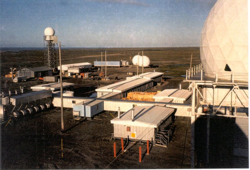
Outline
z   Background
    information
z   Remediation Standard
    Development
z   Example Sites
z   Technical and
    Logistical Challenges
z   Landfill Assessment
    and Remediation
z   Landfill Monitoring
z   Acknowledgements
Background Information
           z   The DEW Line was built
               during the height of the
               Cold War.
           z   Radar sites:
               – 42 sites in Canada were
                 operated between 1955 and
                 1985 by USAF & Canada
               – Replaced by the North
                 Warning System.
               – 21 INAC sites, some
                 abandoned since 1963.
               – INAC has responsibility for
                 numerous similar sites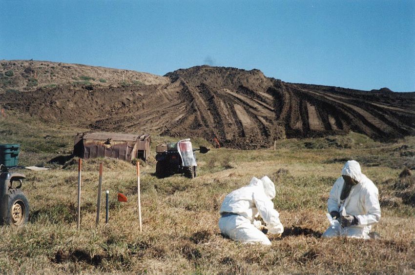
INTRODUCTION:
DND DEW Line Sites
INAC DEW Line Sites
Background Information
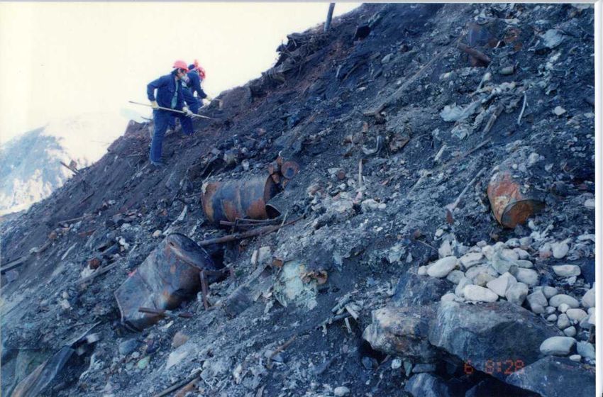
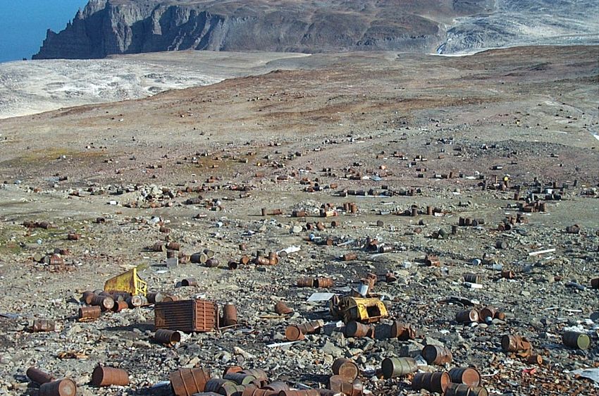
z Waste disposal
with little
environmental
consideration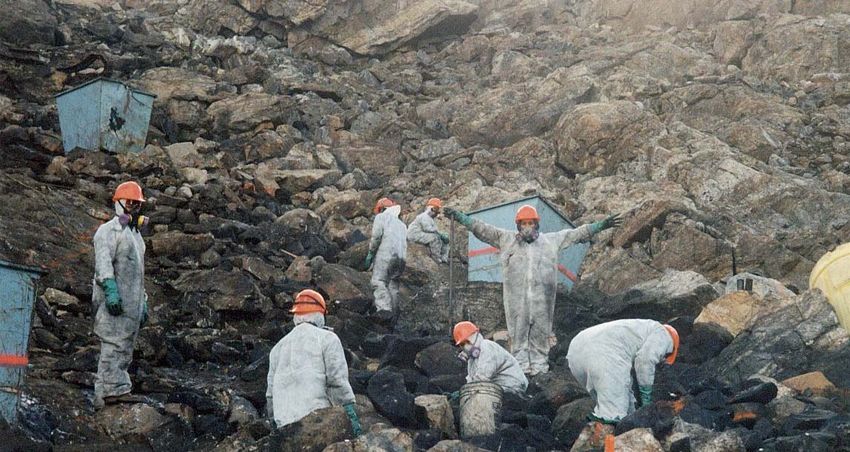
DEW Line Cleanup Protocol
1989-93:
z Assessments took place at the DEW Line.

z   Scientific investigations led to the development of a
    cleanup protocol for the DEW Line (including concept
    cleanup plans for contaminated soil and landfills).

z   Cleanup criteria for contaminants were developed
    specifically for the Arctic - the DEW Line Cleanup Criteria
    (DCC).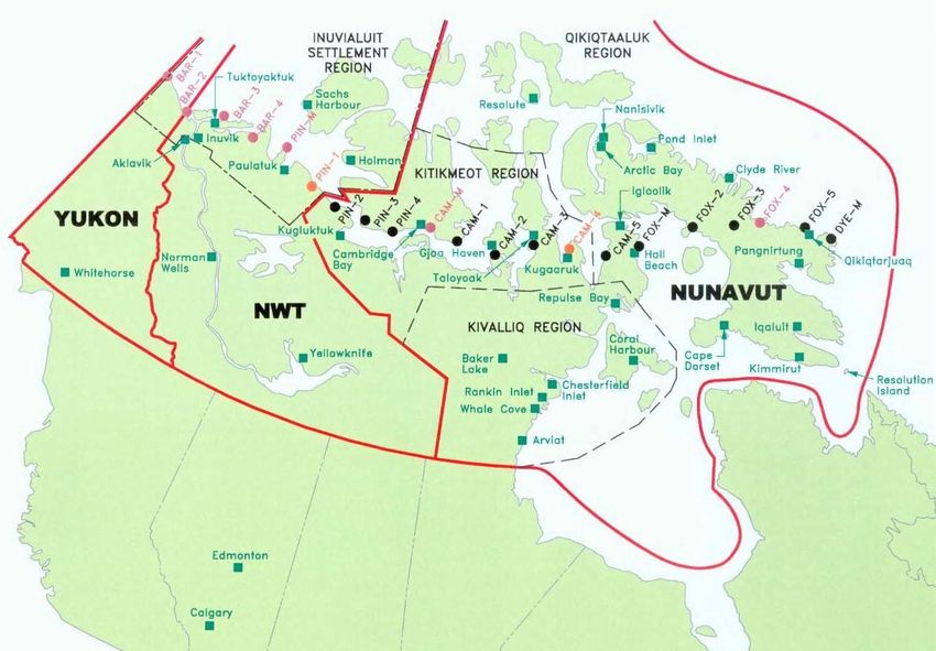
CAPE CHRISTIAN LORAN
HORTON RIVER DEW LINE
PEARCE POINT
ISACHSEN, NT
ISACHSEN, NT
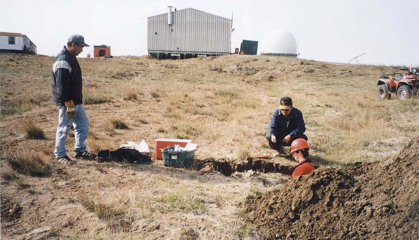
Investigation Phase
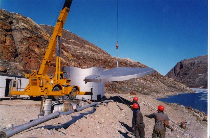
Challenging Factors
z   Construction Season
    – Limited to summer usually 3 –4 months
z   Remote and isolated locations
    – Logistics, on-site analysis, supplies
z   Resources
    – On-site resources: gravel, shale, bedrock, permafrost
    – Contractors and equipment
z   Ecosystem
    – Linear foodchain
z   Global Warming
    – Permafrost degradation
Permafrost degradation above equipment burial area.
Landfill Concept
z Remediation/Closure    of
 Existing Landfills
  – Risk Evaluation
  – Excavate/Remediate
z Development   of New Landfills
  – Non-hazardous
  – Contaminated Soil
Engineering Design
z   The designs require;
       z   demolition of facilities,
       z   On-site disposal of site debris,
       z   Off-site disposal of hazardous materials and
           contaminated soils,
       z   development and closure of landfills,
       z   use of permafrost,
       z   use of existing granular material sources,
       z   site grading.
Landfill Risk Evaluation
z Background information
– Based on National Classification System
z Matrix factors
– Contaminant source
– Pathways
– Receptors
– Special considerations
– Traditional knowledge
z Interpreting the scoreContaminant Source z LandfillExtent z Estimated Depth of Landfill z Presence of Leachate z Presence of Surface Contaminated Soil z Presence of Surface Debris
Pathways
z AerialTransport
z Water Transport
  – Topography
  – Cover material (type and depth)
  – Runoff potential
  – Precipitation
  – Distance to downgradient drainage channels
Receptors
z Downgradient      Freshwater/marine habitat
  – Proximity, usage
z Terrestrial   habitat
  – Extent, usage
z Landuse
  – Occupation, use of drinking water and food
    resources
Unique factors z Special Considerations – Non-generic, site specific factors – Potentially worth 10% of each category z Traditional knowledge – Site workers – Local community
Landfill Evaluation Score
Landfill Evaluation Score – Maximum = 150

Potential Environmental Risk Classification
>100                                 High
>75,
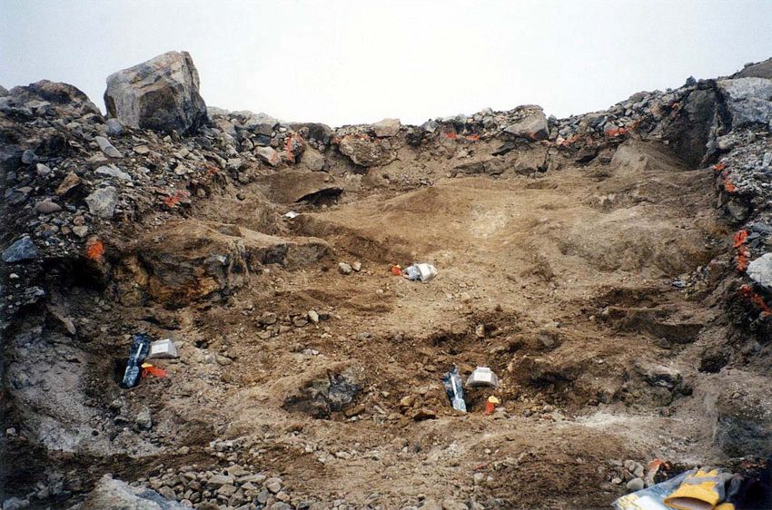
Landfill Remediation
z   High Risk Landfills
    – Excavate
    – Waste separated and classified
z   Moderate Risk Landfills
    – Leachate contain or excavate component
    – More detailed assessment – eg. visual and thermal
      monitoring; and groundwater and soil sampling
z   Low Risk Landfills
    – Regrade against erosion if necessary
    – visual monitoring and soil sampling
Demolition of Facilities
Removal of Site Debris
Landfill
Excavation
Landfill
Excavation
Verification
                  Sampling

   Waste
Classification
Non-Hazardous Waste Landfill
GRANULAR FILL COVER
(TYP.)
0.3m
WASTE INTERMEDIATE GRANULAR
FILL COVER
(MAX)
1m
WASTE
GRANULAR FILL COVER
GRANULAR FILL BERM
NON-HAZARDOUS WASTE
GRANULAR FILL BERM
EXISTING GROUND
NON-HAZARDOUS WASTE LANDFILLLeachate Containment
Modification
GRANULARFILL(THICKNESS
BASEDONDESIGNACTIVELAYER)
RIPRAP
SAND NON-WOVENGEOTEXTILE
ABOVEANDBELOW
GEOMEMBRANE
0.15mMIN. SAND
0.3mMIN. SAND
GEOMEMBRANE 0.7mMIN. SATURATED
GRANULARFILL
0.15mMIN. SAND
LANDFILL WITH LEACHATE CONTAINMENTContaminated Soil Landfill
0.3m DCC TIER CONTAMINATED SOIL
0.15m MIN. INTERMEDIATE GRANULAR FILL COVER
(REQUIRED ONLY FOR LANDFILLING OF SOFT SOILS)
GRANULAR FILL COVER 0.3m DCC TIER CONTAMINATED SOIL
EXISTING GROUND
EXCAVATE TO SATURATED
PERMAFROST
COMPACTED TIER
CONTAMINATED SOIL
SATURATED FROZEN BERM
0.3m MIN. SAND
GEOMEMBRANE
0.15m MIN. SAND
0.3m MIN. GRANULAR FILL NON-WOVEN GEOTEXTILE
ABOVE AND BELOW
GEOMEMBRANE
TIER DISPOSAL FACILITYLandfill
Monitoring
- visual
- soil/groudwater
- thermalAcknowledgments
z Indian and Northern Affairs Canada
– Ms Joanna Ankersmit (Contaminants Sites Program)
– Dr Wayne Ingham (Water and Earth Science
Associates)
z Department of National Defence
– Dew Line Cleanup Team
z Environment Canada
– Lisa Keller, Country RepresentativeContact Information Indian and Northern Affairs Canada Water and Earth Science Associates Les Terrasses de la Chaudiere The Woolen Mill, 4 Cataraqui St. Room 616 Kingston, ON, Canada 10 Wellington St. Gatineau, K7K 1Z7 Quebec, Canada ph: (613) 531 2725 K1A 0H4 Fx: (613) 531 1852 ph: (819) 997-8413 wingham@wesa.ca fx: (819) 953-2590 nahirm@inac.gc.ca
You can also read