Managing flood risk The Great Ouse Tidal River Strategy - Draft for consultation September 2009
←
→
Page content transcription
If your browser does not render page correctly, please read the page content below
The Great Ouse Tidal River Strategy
 Draft for consultation September 2009

managing
flood risk
We are the Environment Agency. It’s our job to look after your
environment and make it a better place – for you, and for
future generations.
Your environment is the air you breathe, the water you drink
and the ground you walk on. Working with business,
Government and society as a whole, we are making your
environment cleaner and healthier.
The Environment Agency. Out there, making your environment
a better place.

Published by:

Environment Agency
Kingfisher House,
Goldhay Way, Orton Goldhay,
Peterborough PE2 5ZR
Tel: 0870 8506506
Email: enquiries@environment-agency.gov.uk
www.environment-agency.gov.uk

© Environment Agency
All rights reserved. This document may be reproduced
with prior permission of the Environment Agency.
September 2009
At the Environment Agency we have overall responsibility
for flood risk management in England and Wales.

Our role                                               Great Ouse Tidal River Strategy
At the Environment Agency we have overall              In view of these challenges we have prepared a
responsibility for flood risk management in England    strategy for the Great Ouse Tidal River which flows
and Wales. Our aim is to reduce the threat of          through Norfolk and Cambridgeshire. The area
flooding to people and property whilst achieving       considered within our strategy boundary extends
the greatest environmental, social and economic        from Earith to King’s Lynn and covers 408km2.
benefits in line with the Government’s principles of
                                                       The aim of this document is to:
sustainable development. Over recent years there
have been a number of major floods, which have         • explain what our Flood Risk Management
increased the demand for resources. In the face of       Strategy aims to achieve;
such challenges we need to be sure we are getting      • publicise our proposals for the Great Ouse
the best value for money, and this means making          Tidal River;
difficult decisions. To help identify sustainable
                                                       • explain the current level of flood risk and the
ways of managing defences in the future, we are
                                                         effects of climate change;
preparing flood risk management strategies in
many areas.                                            • allow you to comment on the proposals and
                                                         to identify any locally sensitive issues;
                                                       • explain what will happen after the strategy
                                                         is adopted.

Silt bars in the Tidal River (downstream of Denver)

                                                                      Environment Agency The Great Ouse Tidal River Strategy   1
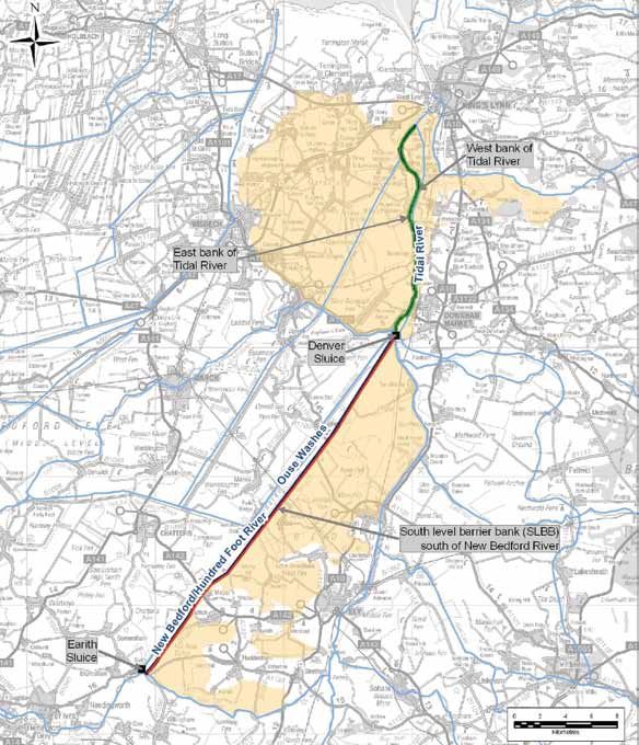
Our study area                                       Aims of the strategy
The strategy covers an area of the Cambridgeshire    The strategy aims to provide a 100-year management plan
and Norfolk Fens shown in the plan below.            for the Great Ouse Tidal River. It will take into account:

There are around 2400 properties and 26,000          • flood risk management – the best way to manage
hectares of agricultural land at risk of flooding      flood risk to people and property over the next
in this area. These are currently protected by the     100 years;
South Level Barrier Bank and Tidal River defences.   • navigation – maintaining navigation access
                                                       where possible;
                                                     • environment – finding ways of improving the
                                                       environment and ensuring our strategy does
                                                       not have a negative impact on the environment.

                                                                                                     Legend

                                                                                                          Study Area

                                                                                                          Sluices

                                                                                                          Strategy
                                                                                                          River

                                                                                                          Watercoursse

                                                                                                          South Level
                                                                                                          Barrier Bank

                                                                                                          Tidal River
                                                                                                          Bank

Map showing the Tidal River Flood Plain study area

                                                                   Environment Agency The Great Ouse Tidal River Strategy   2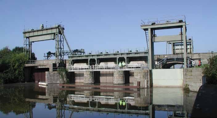
Existing flood risk
Floods are characterised by their size and how often          At present the South Level Barrier Bank flood defence
they occur. The larger a flood, the less often it is likely   provides a minimum standard of protection of
to occur.                                                     1 in 120 to over 750 properties in this area. The Tidal
                                                              River Banks, which are north of Denver, are estimated
For example a flood with a 1% annual probability of
                                                              to provide a standard of 1 in 500 or more to around
occurring is also expressed as a flood that has a 1 in
                                                              1600 properties.
100 chance of occurring in any given year. If a flood
of this magnitude occurs in one year the chance of it
                                                              Climate change
occurring the following year is still the same, 1 in 100.
                                                              Government guidance sets out how we should predict
A flood with 0.5% annual probability of occurring             the effects that climate change may have on flood
is expressed as a flood that has a 1 in 200 chance            levels in the future. Using computer flood modelling
of occurring in any given year. A flood of this size          we can identify how many properties may be affected
occurs less frequently than a flood with a 1% annual          by these changes. It is expected, for many areas, the
probability, but it is a larger flood and so causes more      standards of protection against flooding will decrease
flooding of land and property.                                over time due to climate change.

Currently there are approximately 2400 properties in
the Great Ouse Tidal River flood plain which would
be at risk of flooding should the defences fail. Over
the next 100 years this could rise to around 5000
properties due to the effects of climate change and
sea level rise.

Aerial view of the Denver Complex                             Properties protected by the Tidal River Banks

                                                                                 Environment Agency The Great Ouse Tidal River Strategy   3
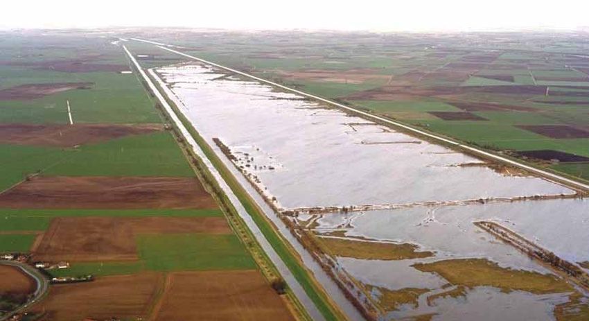
The Ouse Washes
In 1630, the Dutch engineer Cornelius Vermuyden             Denver Sluice. This has brought major flood risk
created the two Bedford Rivers. The purpose of this         benefits for the South Level but it has been achieved
was to improve the drainage of the Great Ouse between       at the expense of reduced ‘flushing’ flows in the Great
Earith and Downham Market. The area between the             Ouse Tidal River and this in turn has led to higher silt
rivers (now called the River Delph and the New Bedford      levels in the Tidal River. These high bed levels have a
River) is 20 miles long and almost a mile wide, and         negative impact on the drainage of the Ouse Washes
it acts as a flood storage reservoir in the winter (and     as bed levels are often too high to allow water to
increasingly in summer). This area is called the Ouse       drain by gravity into the river. As a result there has
Washes and is drained by the Great Ouse Tidal River.        been increased flooding on the Ouse Washes for
                                                            longer periods and to greater depths.
The Ouse Washes are the largest area of frequently
flooded grazing marsh in the UK. This makes them            High river bed levels and increased flooding on the
attractive to certain bird species (including breeding      Ouse Washes create a number of issues:
waders and overwintering birds). It is therefore now an     • high bed levels can impede navigation;
area of international conservation importance and is a
designated Special Protection Area.                         • increased flooding harms habitat suitable for many
                                                              of the rare birds which visit the site;
Over the past 75 years river bed levels in the Great        • it affects landowners who use the Ouse Washes as
Ouse Tidal River have risen. Bed levels rise during           grazing marsh;
droughts as silt is drawn in from the sea, on the tide,
and settles in the Great Ouse Tidal River – primarily       • users of Welney Road, which crosses the Ouse
downstream of Denver Sluice. High river flows,                Washes, must take a 30-mile detour;
following periods of drought, scour the majority of         • as bed levels continue to rise in the future, the
this silt back out to sea, but sometimes not all of it is     standard of protection provided by the South Level
removed. In addition, as a result of the construction of      Barrier Bank may reduce;
the Great Ouse Flood Protection Scheme 50 years ago,        • anticipated future sea level rise will make the
high freshwater flows in the Ely Ouse are now routed          problem of managing silt levels in the Great Ouse
down the Flood Relief Channel instead of through              Tidal River increasingly difficult in future decades.

The Ouse Washes in flood

                                                                           Environment Agency The Great Ouse Tidal River Strategy   4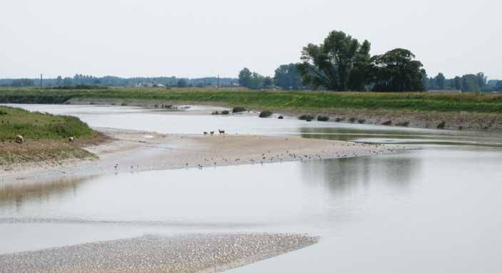
How we have developed our strategy
We apply a clearly defined approach to assessing flood                    • do minimum – this would mean that we would
risk management options which is set by the Department                      continue to maintain the existing structures, walls
for Environment, Food and Rural Affairs (Defra).                            and embankments. However, at the end of their
                                                                            design-life these assets would not be replaced.
The key aim of the strategy is to identify how we can
manage flood risk. We have developed the strategy                         • do something – under this approach we would
to follow four key aims of: sustainability; maximising                      change how we currently manage flood risk. A
environmental benefit; ensuring health and safety;                          number of different types of options were considered
and securing value for money.                                               for this. These are summarised on the next page.

To develop our strategy we identified all the possible
options to manage flood risk at a high level. We
identified the following options:
• do nothing – this would mean that all of the work we
  currently do now, such as flood warning, channel and
  defence maintenance, would stop. This is a standard
  option against which the benefits and costs of the
  other options are compared.

Blacktailed Godwit – one of the rare birds which visits the Ouse Washes   Erosion protection on the Tidal River flood defences

                                                                                             Environment Agency The Great Ouse Tidal River Strategy   5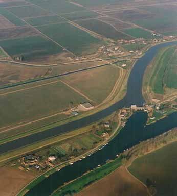
‘Do something’ options
Hold the line of defence at an agreed standard of           Managed realignment of the Tidal River East Bank
protection (various standards considered)                   This option would involve allowing flood waters to
Over time, it is predicted that Tidal River siltation and   overtop the Tidal River Bank which is located between
the risk of increasing flood flows as a result of climate   the Tidal River and the Flood Relief Channel.
change will lead to a reduction in the standard of
protection of the South Level Barrier Banks.                River narrowing
Under this option, we would undertake works to raise        Narrowing the river channel would increase the speed
embankments as and when necessary. The need for             of the flow of water in the river. This could help with
bank raising would be determined by assessing the           flushing silt and lowering bed levels.
cost of raising the banks against the value of the
properties and agricultural land protected by those         Improving or changing the operation of existing
banks. Therefore for some of the banks we may still         structures – Denver Sluice
have to accept a lower standard of protection than is       The Denver Sluice allows water from the Ely Ouse to
currently provided.                                         discharge into the Tidal River. By increasing flow through
This option would also involve proactive maintenance        Denver Sluice there would be an increase in the flushing
and replacement of the low walls along embankment           flows in the Tidal River which could help lowering bed
crests when necessary. In some locations crest walls        levels by flushing silt out of the river.
would have to be rebuilt after bank raising or the
walls would have to be increased in height instead          Improving or changing the operation of existing
of bank raising.                                            structures – Earith Sluice
                                                            The Earith Sluice allows water from the Tidal River to
Bank Reinforcement on the South Level Barrier Bank          enter the River Delph and flood the Ouse Washes. The
This option would include 2.5km length of erosion           level of the sluice gate (the ‘drawmark’) is currently set
protection works at the southern end of the South           in byelaw. There is an opportunity to reduce the flooding
Level Barrier Bank and a further short length of erosion    of the Ouse Washes by changing this level to allow less
protection at the northern end.                             water into the River Delph, particularly during the winter
                                                            months. This would also mean more water flows down
Tidal Barrier at King’s Lynn                                the Tidal River which would aid the flushing of silt.
This could be north or south of the port of King’s Lynn
                                                            Build a new pumping station to drain the Ouse Washes
and would provide a surge barrier that could be shut
when extreme surge tides occur.                             A pumping station located at the Welmore Lake Sluice (at
                                                            the north end of the Ouse Washes) could be used to drain
Replacement of crest walls                                  the Ouse Washes when natural discharge is not possible.
                                                            This would reduce flooding of the Ouse Washes.
Many of the embankments on the Tidal River have
low crest walls which vary between 0.2m and 1.5m
                                                            Dredging of the Tidal River
in height. The walls have been repaired recently but
replacement is predicted to be necessary after 25 years     By dredging the Tidal River the bed levels could be
to maintain their flood defence capability.                 reduced. This would reduce the flooding of the Ouse
                                                            Washes and reduce flood risk on the South Level
Flood storage                                               Barrier Bank.
This would involve creating flood storage areas which
                                                            Build a new pumping station at Denver
could be used to hold water during floods. One of the
areas investigated for this is the land directly adjacent   A pumping station at Denver Sluice could be used to
to the South Level Barrier Bank at the southern end of      pump water from the Ely Ouse into the Tidal River even
the bank.                                                   when gravity discharge at the sluice is not possible.
                                                            (note – without a pumping station water can only be
                                                            discharged through the Denver Sluice when the water
                                                            levels in the Tidal River are lower than the water levels
                                                            in the Ely Ouse.)

                                                                           Environment Agency The Great Ouse Tidal River Strategy   6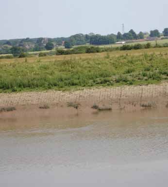
How we selected the most appropriate option
We engaged with external stakeholders to share ideas and expertise and we then
assessed all options against the following criteria:

1. The cost of each option compared with the benefits gained, including
   the number of properties affected.

2. Whether the option would effectively manage flood risk.

3. The environmental impact of each option.

Our thorough assessment of the options led us to dismiss the following:

Option                           Justification for dismissal

Tidal Barrier at King’s Lynn     The existing banks on the Tidal River are of a high standard (1 in 500+).
Flood storage                    Therefore, there is not enough additional benefit to be gained within
                                 the study area by constructing a Tidal Barrier at King’s Lynn or a new
                                 flood storage area in order to further protect properties in the Tidal
                                 River flood plain.

Managed realignment of the       This would result in saline water from the Tidal River entering the Flood
Tidal River East Bank            Relief Channel (which is a freshwater channel). Not only would this have
                                 an adverse environmental impact, but it could also cause the Flood Relief
                                 Channel to start accumulating silt creating greater flood risk for the Ely
                                 Ouse catchment upstream of Denver.

River narrowing                  This option was found to have less impact on bed levels than improving
                                 gravity discharge through Denver Sluice, which is a very low cost option.

Build a new pumping station to   This is an environmentally unsustainable option. As sea levels rise the
drain the Ouse Washes            drainage of the Ouse Washes will continue to deteriorate and the amount
                                 of pumping required will increase, escalating future costs and increasing
                                 carbon emissions.

Dredging of the Tidal River      This would involve dredging a huge amount of silt – equivalent to the
                                 volume of ten football pitches to a depth of the goal posts. The costs of this
                                 are prohibitive. In addition, there is a chance that silt levels could return to
                                 the previous state within four to six months.

Build a new pumping              This option was found to have less impact on bed levels than improving
station at Denver                gravity discharge through Denver Sluice, which is a very low cost option in
                                 comparison to the building of a new pumping station.

                                                                     Environment Agency The Great Ouse Tidal River Strategy   7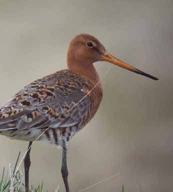
The importance of Denver Sluice
First built in 1651, Denver Sluice was constructed       We aim to discharge as much water out of the Denver
to protect the South Level fens from flooding by         Sluice as possible. During the last year the dedicated
providing a secure point for discharge of flood water    Denver Sluice operators have managed to get 85% of
and by preventing tidal flooding of the fens. Fifty      flows though the sluice compared to the theoretical
years ago, this original function of Denver Sluice was   maximum. This is higher than in previous years, and is
taken over by the Flood Relief Channel and the Tail      crucial to getting the river bed down to lower levels and
Sluice near King’s Lynn. The main purpose of Denver      then keeping them at a lower range.
Sluice now is to prevent the build up of silt in the
                                                         It is possible that future sea level rise may make gravity
Tidal River Great Ouse.
                                                         flows through the sluice more difficult, and this will
The adjacent Denver lock provides an essential           need to be monitored. However, as long as gravity flows
navigation link between the Great Ouse navigation        are achievable it is important that the sluice is used to
and the remainder of the inland waterway system.         its maximum capacity.
This may be accessed through Salter’s Lode lock on
the west bank of the Tidal River 500m downstream of
Denver Lock.

Flows discharged through Denver Sluice from the Ely
Ouse to the Tidal River help flush out silt and keep
bed levels down. Modelling of the river has shown
that, apart from natural flood flows in the Bedford
Ouse, gravity flows through the sluice are the single
most important factor for siltation management in
the river.

Denver Sluice

                                                                        Environment Agency The Great Ouse Tidal River Strategy   8
Our preferred strategy
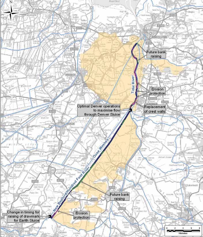
Our preferred strategy for this area is to: Management activities:
• maximise flows through Denver Sluice to flush We currently undertake a range of flood risk
out silt in the Tidal River; management activities and we are proposing to
continue with these:
• new erosion protection as well as repair and
replacement of existing erosion protection; • improving the flood warning service and promoting
its wider use;
• changing how we operate Earith Sluice;
• channel maintenance, where necessary;
• replacement of crest walls on top of embankments
expected in 2035; • maintaining existing flood defences;
• the standard of protection of the South Level Barrier • continuing to influence planning and development
Bank is predicted to fall to 1 in 20 years in around proposals;
2080. When this happens we will carry out bank- • continuing to provide advice on protecting individual
raising work to ensure that the standard does not properties to increase their resistance to flooding.
fall below 1 in 20;
• raise the West Bank defences of the Tidal River
between Old Bedford Sluice and St Germans
pumping station when the standard of protection
falls to 1 in 100 years in around 2080;
• raise the East Bank defences of the Tidal River
between Wiggenhall St Peter and Saddlebow when
the standard of protection falls to 1 in 75 years in
around 2100;
• we will also continue with a programme of
monitoring the river flows and bed levels in the Tidal
River to gauge the effectiveness of the strategy in
lowering bed levels and improving the drainage of
the Ouse Washes.
We estimate that, over the 100-year strategy period,
the standard of protection provided by the Tidal
River Banks will be lowest for the East Bank between
Wiggenhall St Peters and Downham Market, but even
here the standard will only reduce to 1 in 90 until
around 2085. However, as stated above, the standard
of protection provided by the South Level Barrier Bank
may drop to as low as 1 in 20 by 2080.
Environment Agency The Great Ouse Tidal River Strategy 9Our preferred strategy
Legend
Study Area
Sluices
Strategy
River
Watercoursse
South Level
Barrier Bank
Tidal River
Bank
Environment Agency The Great Ouse Tidal River Strategy 10Contact details If you have any queries or issues you wish to discuss, please contact: Sadia Moeed NCPMS Environment Agency Kingfisher House Goldhay Way Orton Goldhay Peterborough PE2 5ZR Telephone: 08708 506 506 Email: sadia.moeed@environment-agency.gov.uk
Would you like to find out more about us,
or about your environment?

Then call us on
08708 506 506* (Mon-Fri 8-6)
email
enquiries@environment-agency.gov.uk
or visit our website
www.environment-agency.gov.uk

incident hotline 0800 80 70 60 (24hrs)
floodline 0845 988 1188

* Approximate call costs: 8p plus 6p per minute (standard landline).
Please note charges will vary across telephone providers.

      Environment first: This publication is printed on paper made
      from 100 per cent previously used waste. By-products from
making the pulp and paper are used for composting and fertiliser,
for making cement and for generating energy.

GEAN0909BQYC-E-E
You can also read