MAPPING AN URBAN CITY CENTRE FOR SEISMIC RISK ASSESSMENT: APPLICATION TO VALENCIA (SPAIN) - The International Archives of ...
←
→
Page content transcription
If your browser does not render page correctly, please read the page content below
The International Archives of the Photogrammetry, Remote Sensing and Spatial Information Sciences, Volume XLIV-M-1-2020, 2020
               HERITAGE2020 (3DPast | RISK-Terra) International Conference, 9–12 September 2020, Valencia, Spain

            MAPPING AN URBAN CITY CENTRE FOR SEISMIC RISK ASSESSMENT:
                         APPLICATION TO VALENCIA (SPAIN)

                                              L. Basset-Salom 1, 2, *, A. Guardiola-Víllora 1, 2
   1
       Dept. of Continuum Mechanics and Theory of Structures, Universitat Politècnica de València, Cno. Vera s/n, 46022 Valencia,
                                              Spain, (lbasset, aguardio)@mes.upv.es
                          2
                            Research Centre PEGASO, Universitat Politècnica de València, Valencia, Spain

                                                         Commission II - WG II/8

KEY WORDS: Mapping, Buildings database, Heritage, Seismic risk, Seismic vulnerability

ABSTRACT:

Seismic risk in urban city centres may be high, even when the city is in low to moderate seismic areas, due to the vulnerability of the
residential buildings. To assess the seismic vulnerability and estimate the expected damage in case of occurrence of an earthquake,
an up-to-date detailed and comprehensive information of the residential building stock, such as number of dwellings, location, age,
geometry, stiffness irregularities, structure, constructive system and practices, among others, is needed. This paper presents the
authors experience, describing the step by step procedure followed to obtain the required information to classify and catalogue the
residential buildings of the historical neighbourhoods of the city of Valencia into a database. Official sources, like the Cadastral
Database, the website of the Urban Planning Service of the city of Valencia, the Municipal Historical Archive of Valencia, and the
Historical Archive of the Valencian Architects Society, but also unexpected references are shared, pointing out the information that
has been retrieved and its reliability. Additionally, relevant information must be obtained with an on-site data collection. This field
work is essential not only to prove the accuracy of the abovementioned data but also to define some of the parameters related to the
building vulnerability.The built database, included in a GIS system, has been used by the authors for seismic risk studies. This
procedure can be implemented in future assessments at an urban scale.

                      1. INTRODUCTION                                    Regardless of the selected method, a detailed urban scale
                                                                         vulnerability assessment requires a thorough previous collection
Urban city centres are, in general, characterized by a rich              of accurate and comprehensive data of the residential building
historic heritage, including not only monumental or religious            stock (such as location, age, geometry, stiffness irregularities,
buildings but also residential buildings varied in age and styles,       structure, constructive system and state of preservation, among
with a majority of them made of unreinforced stone or brick              others) which are usually stored in a database.
masonry and, quite often, with bad level of maintenance.
                                                                         In this paper the step by step procedure (with application to the
The occurrence of recent earthquakes affecting urban city centres        city of Valencia) is described, pointing out the information
(L'Aquila, 2009, Lorca, 2011, Emilia Romagna, 2012, Katmandu,            retrieved from the available sources and from the on-site survey,
2015, Amatrice, 2016, Bagan, 2016, etc.) has highlighted the need        an irreplaceable key for data validation. These up-to-date data
to assess the seismic risk, even in low to moderate seismic hazard       have been subsequently organised and stored in a georeferenced
countries in which less strong earthquakes can, nonetheless, cause       database included in a Geospatial Information System (GIS),
severe damage, due to the high vulnerability of the buildings. The       which has been used for seismic risk assessment of some
main reason is that many buildings don’t meet the requirements to        neighbourhoods in Valencia. This procedure can be
withstand seismic actions, neglecting, in addition, other factors        implemented in future urban scale assessments.
which are relevant for an adequate seismic performance such as
geometric or stiffness regularities (Basset-Salom et al., 2014).           2. INFORMATION OF THE BUILDING STOCK FOR
                                                                                SEISMIC VULNERABILITY ASSESSMENT
There are different approaches to assess the seismic
vulnerability of buildings (Calvi et al., 2006; Barbat et al., 2010;     The type of required information of the residential buildings
Novelli 2017), namely empirical methods such as the Damage               depends on the vulnerability assessment method.
Probability Matrix, DPM, (Whitman et al., 1973; Dolce et al.,
2003) or the Vulnerability Index Methods, VIM, (Benedetti,               The Risk-UE level 1 Vulnerability Index Method (Milutinovic,
Petrini, 1984; Giovinazzi, Lagomarsino, 2002; Milutinovich,              Trendafiloski, 2003), developed under the framework of the
Trendafiloski, 2003); analytical methods (D’Ayala, Speranza,             European research project Risk-UE (Mouroux et al., 2004) has
2002; Barbat et al., 2008; Irizarry et al., 2011; Lamego et al.,         been proved to be suitable for seismic vulnerability assessment
2017) and hybrid methods (Kappos et al., 1998; Maio et al,.              of residential buildings in urban areas, where adequate estimates
2016; Ferreira et al., 2017). The choice depends on the scale of         on the seismic intensity and building stock information are
the study, the resources for data collection or data availability and    available. This method was successfully applied in the 7
the required results (Guéguen et al 2007, Vicente et al. 2011,           European cities involved in the project (Barcelona, Bitola,
Chever 2012; Novelli 2017).                                              Bucharest, Catania, Nice, Sofia and Thessaloniki) and has been

* Corresponding author

                                                 This contribution has been peer-reviewed.
                  https://doi.org/10.5194/isprs-archives-XLIV-M-1-2020-817-2020 | © Authors 2020. CC BY 4.0 License.                  817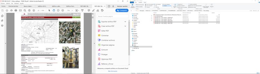
The International Archives of the Photogrammetry, Remote Sensing and Spatial Information Sciences, Volume XLIV-M-1-2020, 2020
HERITAGE2020 (3DPast | RISK-Terra) International Conference, 9–12 September 2020, Valencia, Spain
used in the last 15 years in several studies carried out in Spain BUILDING DEFINITION
namely in Barcelona (Roca et al., 2006; Lantada, 2007; Lantada TYPOLOGY
et al., 2010; Lantada et al., 2018), Gerona (Irizarry et al., 2012), M1.1 Rubble stone masonry bearing walls
Granada (Feriche, 2012), Lorca (Feriche et al., 2012; Martínez-
M1.2 Simple stone masonry bearing walls
Cuevas, Gaspar-Escribano, 2016; Rodenas et al., 2018),
M1.3 Massive stone masonry bearing walls
Valencia (Basset-Salom, Guardiola-Víllora, 2020) and Vélez-
Málaga (Feriche et al., 2009), among others. M2 Adobe
M3.1 Unreinforced masonry (URM) bearing
The seismic vulnerability of the building is defined with a walls with wooden slabs
vulnerability index, which accounts for the structural typology, M3.2 Unreinforced masonry (URM) bearing
construction materials and the specific features that might walls with masonry vaults
influence its seismic performance, implemented by means of M3.3 Unreinforced masonry (URM) bearing
Masonry walls with composite steel and
regional or behaviour modifiers.
masonry slabs
To characterise the residential buildings for seismic M3.4 Bearing walls with reinforced concrete
vulnerability assessment with the abovementioned method, the slabs
following information related to the building itself and to its M4 Reinforced or confined masonry
location within the block is needed: age, structural typology, bearing walls
geometrical configuration, stiffness irregularities, state of M5 Overall strengthened masonry
preservation, aggregate building position and existing anti- buildings
seismic or strengthening devices. RC1 Concrete moment frames
RC2 Concrete shear walls
- The age of the building is essential because it helps RC 3.1 Concrete frames with regular
defining the construction system and the quality of the unreinforced masonry infill walls
materials, based on the constructive recommendations, the RC3.2 Irregular concrete frames with
codes in force at that moment and the particularities in the Concrete unreinforced masonry infill walls
region. RC4 RC dual systems (RC frame and wall)
RC5 Precast concrete walls
- The structural typology of the building is defined RC6 Precast concrete frames, concrete shear
according to the Building Typology Matrix (Table 1) walls
proposed by Risk-UE (Milutinovic, Trendafiloski, 2003), S1 Steel moment frames
which classifies structures with a similar ability to S2 Steel braced frames
withstand seismic loads. Adequate values of the S3 Steel frames with unreinforced
vulnerability indices are assigned to each structural Steel masonry infill walls
typology within the frame of the fuzzy set theory S4 Steel frames with cast in place
(Giovinazzi, Lagomarsino, 2002), indicating its concrete shear walls
membership to one of the six EMS 98 vulnerability
S5 Steel and reinforced concrete
classes (Grüntal, 1998): from A (highest vulnerability) to
composite systems
F (lowest vulnerability).
Wood W Wood structures
- The geometrical configuration influences the Table 1. Building Typology Matrix proposed by Risk-UE
vulnerability of the buildings. The number of storeys, (Milutinovic and Trendafiloski 2003).
area, perimeter and volume of the building must be
obtained to define the geometric irregularities, both in
plan (horizontal irregularity) and elevation (vertical
irregularity). The difference in height between adjacent
buildings, when greater than, or equal to, two storeys
(see Figure 1) must be included too because, in this case,
the risk of pounding effects is not negligible.
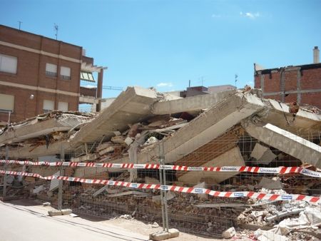
- The existence of a soft storey and/or short columns must be
recorded. These stiffness irregularities have proved to be
relevant in the seismic response of buildings, as shown in the
pictures of Figure 2, corresponding to the effects of Lorca
11th May 2011 earthquake. Figure 1. Differences in height (credit: the authors).
- Despite the influence of the construction techniques, the
state of preservation is a determinant factor in the
buildings seismic performance, especially in the case of
unreinforced masonry (URM) buildings, not only for the
building itself, but also due to the lack of the stabilizing
contribution of neighbouring cells when the maintenance
level is bad or the building is ruined (Carocci,
Lagomarsino, 2009; Basset-Salom, Guardiola-Víllora,
2013; Guardiola-Víllora, Basset-Salom, 2019). Figure 3
shows buildings of the same typology but with different Figure 2. Buildings with short columns after Lorca 11th May
state of preservation. 2011 earthquake (credit: the authors).
This contribution has been peer-reviewed.
https://doi.org/10.5194/isprs-archives-XLIV-M-1-2020-817-2020 | © Authors 2020. CC BY 4.0 License. 818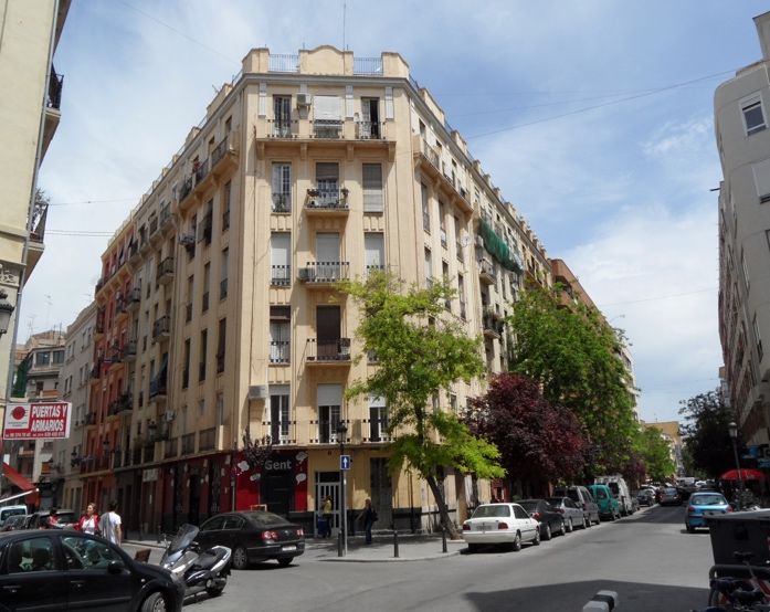
The International Archives of the Photogrammetry, Remote Sensing and Spatial Information Sciences, Volume XLIV-M-1-2020, 2020
              HERITAGE2020 (3DPast | RISK-Terra) International Conference, 9–12 September 2020, Valencia, Spain

  - The aggregate building position (relative position of the           3. BUILDING THE DATABASE FOR SEISMIC RISK
    building in plan with respect to the rest of the buildings in                      ASSESSMENT
    the same block) is a factor which affects directly the
    seismic vulnerability. Three locations are considered:            The process of building the database for seismic risk assessment
    middle, corner and header (Figure 4a, 4b and 4c), being           can be structured in 3 stages: preliminary office work; data
    the header position the worse one in terms of the building        collection and, finally, data processing and mapping.
    seismic response. When a building is adjacent to a long-
    term empty plot (Figure 4d) it has to be considered as a          3.1 Preliminary office work
    corner or header building.
                                                                      The preliminary office work consists in preparing the skeleton
  - Finally, information about any existing anti-seismic device       of the georeferenced database (DB) of the building stock of the
    in the building (such as quoins, ring beams, ties, etc) must be   urban area under study.
    collected. These devices have been proved to be effective in
    masonry buildings in Lorca during the 11th May 2011               Each record should correspond to a building, identified by the
    earthquake (Guardiola-Víllora, Basset-Salom, 2014).               block and the plot number and its geographical coordinates. To
                                                                      link this information with the geographical coordinates, the DB
                                                                      is built from the Spanish Cadastral Database (SEC, 2020),
           a) b)                 c)               d)                  allowing a complete geometrical and geographical
                                                                      characterization of the building stock.

                                                                      An example of how the information is given in the cadastral
                                                                      database is shown in Figure 5.

                                                                      When data are extracted from the Cadastral Database, many
                                                                      records (rows), each one related to a different construction part
                                                                      of the same building, are identified with the same reference
                                                                      number (Refcat), corresponding to the same block (masa) and
                                                                      plot (parcela), as can be seen in the table of Figure 5.

Figure 3. State of preservation: a) good, b) medium, c) bad,
      d) ruined and unoccupied (credit: the authors).

 a)                                   b)

 c)                                   d)

Figure 4. Aggregate building position; a) middle, b) corner,          Figure 5. Cadastral Database: a) cadastral map, b) building plan,
     c) header, d) adjacent to a long-term empty plot                  c) shapes corresponding to each construction part of the same
                   (credit: the authors).                                            building, d) records (SEC, 2020).

                                              This contribution has been peer-reviewed.
               https://doi.org/10.5194/isprs-archives-XLIV-M-1-2020-817-2020 | © Authors 2020. CC BY 4.0 License.                  819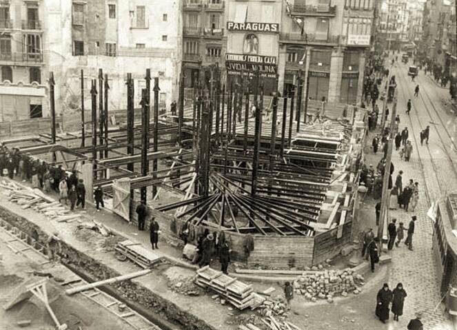
The International Archives of the Photogrammetry, Remote Sensing and Spatial Information Sciences, Volume XLIV-M-1-2020, 2020
HERITAGE2020 (3DPast | RISK-Terra) International Conference, 9–12 September 2020, Valencia, Spain
In this Figure, each construction part is identified according to 3.2.1 Urban Planning Service of the City of Valencia: The
its shape, the number of storeys involved and the geographical Urban Planning Service of the City of Valencia can be accessed
coordinates. For example, the properties of the white rectangle on-line through the City Council geoportal
at the ground floor are represented in the first row. The shapes (https://geoportal.valencia.es/home/), which provides on-line
in striped, diagonal square grid, dotted, and solid patterns city maps and detailed urban information of the buildings
correspond, respectively, to the rows in the table with the same (Figure 7) or through the City Council website
labels on the left. (https://www.valencia.es/ayuntamiento/urbanismo.nsf) where
the documents of the urban plans can be downloaded.
To check which area corresponds to each row, there is a
measuring tool in the Cadastral Database viewer, allowing areas Several Special Protection Plans have been drafted, having as
and lengths to be measured (Figure 6). scope of action a district of the city of Valencia. In general,
these plans are intended to promote the renovation,
rehabilitation and reconstruction of the residential buildings, the
conservation of the heritage buildings, the creation of services
(social, cultural and educational), the regeneration of public
spaces and the revitalisation of the corresponding district.
This is the case of the Special Protection Plans of L’Eixample
district (approved in 2005 and 2006 respectively), the Special
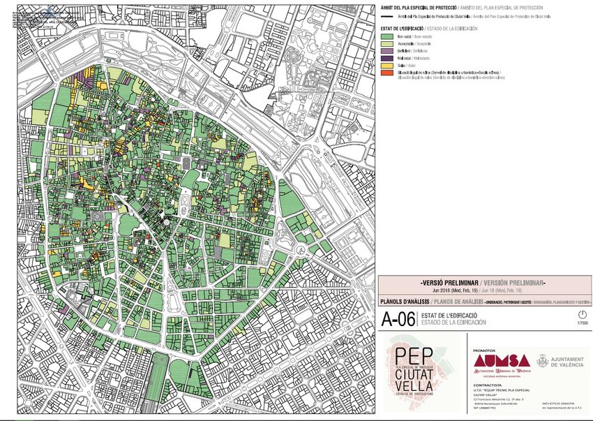
Protection Plan of Ciutat Vella (provisionally approved in 2019)
or the Special Protection Plan of El Cabanyal (in process of
approval).
The documents included in these plans (catalogue of listed
buildings, reports and maps) provide information of the
protection grades, the state of the building, the property status,
the number of storeys, the age, etc. However, the information
Figure 6. Measuring tool in the Cadastral Database (SEC, 2020). about the structural system is, sometimes, not as accurate as
needed.
All the records corresponding to the same building (with the
same block, plot and reference number) are condensed into a An example of a database record of the catalogue and of the
single record and transferred to the DB (still under construction state of preservation map of the preliminary version of the
at this stage) for the seismic risk assessment. The total built area Special Protection Plan of Ciutat Vella are shown, respectively,
of the building is calculated by adding the area of each part. in Figures 8 and 9.
Subsequently, for each record (each building), the following 3.2.2 Institutional sources: The original (or rehabilitation)
information is obtained from the Cadastral Database: all the project of the residential buildings can be found in some
geometrical dimensions (plot area, perimeter at ground floor, institutional sources such as the Municipal Historical Archive of
façade length, building dimensions at each storey, etc), the total Valencia (MHAV), the Architectural Information Centre of the
built area, the number of storeys, the main occupancy use and Architecture School in Valencia (CIA-ETSA), the institutional
the age. The age of the building included in the Cadastral repository of the Universitat Politècnica de Valencia (UPV-
Database corresponds to the year of construction or, sometimes, Riunet) or the Historical Archive of the Valencian Architects
to the year of the last retrofitting intervention in the building, Society.
even in the case of a non-structural intervention. This is one of
the reasons why the age of the building must be validated with Normally the documents of these architectural projects contain
the field survey and/or with the original project when available. the year in which they were drafted, the name of the architect,
the distribution plans, the elevations, a section, a brief
3.2 Data collection. Application to Valencia description of the structure in the constructive report or in the
budget and, sometimes, depending on the date, several
The purpose of the data collection is to validate, complete and structural plans and other constructive details.
enhance the information retrieved from the Cadastral Database,
adding structural system description, construction details and The MHAV has no digitalized version, at the moment, of the
the state of preservation, essential to evaluate the building stored projects, which must be consulted on-site, but it is the
seismic response. only place where projects dating from the 18th century can be
found.
Normally these data are obtained from regional or local sources
where the city urban plans or the architectural projects can be The CIA-ETSA has digitalized and non-digitalized documents
consulted. from several private donations such as the Rieta collection1. The
This part of the paper refers to the available and reliable sources digitalized versions can be accessed on-line at the UPV-Riunet.
in Valencia such as the Urban Planning Service or institutions
like the Municipal Historical Archive of Valencia or the Examples of documents retrieved from the MHAV, the CIA-
Architectural Information Centre of the School of Architecture ETSA and the UPV-Riunet, are shown in Figure 10, Figure 11
of Valencia, among others. It should be pointed out that there and Figure 12, respectively.
are similar sources in other cities.
1
Finally, it is always highly recommended to carried out an on- This collection contains the original projects of the Valencian
site data collection. architect Joaquín Rieta Sister, donated by his family to the CIA-
ETSA.
This contribution has been peer-reviewed.
https://doi.org/10.5194/isprs-archives-XLIV-M-1-2020-817-2020 | © Authors 2020. CC BY 4.0 License. 820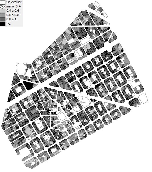
The International Archives of the Photogrammetry, Remote Sensing and Spatial Information Sciences, Volume XLIV-M-1-2020, 2020
              HERITAGE2020 (3DPast | RISK-Terra) International Conference, 9–12 September 2020, Valencia, Spain

  Figure 7. Urban information of a building provided by the
    Urban Planning Service on the Valencia City Council.

                                                                   Figure 10. Example of a structure plan, budget and constructive
                                                                                     report (Source: MHAV).

Figure 8. Record file of a building included in the Catalogue of
 listed buildings of the Special Protection Plan of Ciutat Vella
              (Source: Ayuntamiento de Valencia).
                                                                    Figure 11. Structure plans, Moratin Street no. 3 (Source: Rieta
                                                                             Sister, 1941, Rieta Collection, CIA-ETSA).

  Figure 9. Special Protection Plan of Ciutat Vella: State of      Figure 12. Structure plans, Gran Via Marqués del Turia Avenue,
    preservation map. (Source: Ayuntamiento Valencia).                        (Source: Rieta Sister, 1929, UPV- Riunet).

                                               This contribution has been peer-reviewed.
                https://doi.org/10.5194/isprs-archives-XLIV-M-1-2020-817-2020 | © Authors 2020. CC BY 4.0 License.              821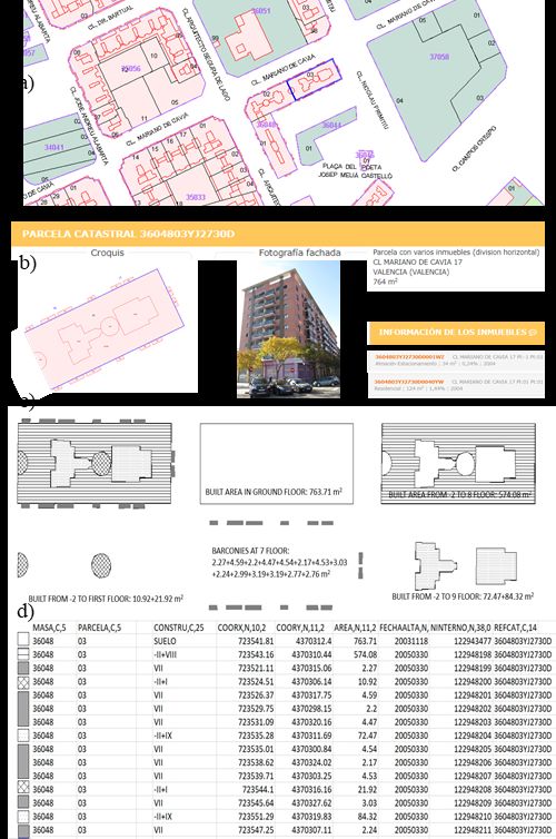
The International Archives of the Photogrammetry, Remote Sensing and Spatial Information Sciences, Volume XLIV-M-1-2020, 2020
               HERITAGE2020 (3DPast | RISK-Terra) International Conference, 9–12 September 2020, Valencia, Spain

3.2.3 Other sources: Structural information of the                    3.2.4 On-site survey: Once the information retrieval process
residential building stock in Valencia can also be found, but         from the different sources is finished and all the records have
only in very specific cases, in other reliable sources, such as the   been transferred to the preliminary database, it is essential to
Valencia’s Architecture Guide (Figure 13) of the Valencian            carry out an exhaustive on-site data collection to validate and
Architects Society (CTAV).                                            complete the retrieved information, especially age, number of
                                                                      storeys, structural typology, constructive system, stiffness
The Iberian DOCOMOMO focuses on the architectural heritage            irregularities (short column, soft storey), geometry, state of
of the Modern Movement. The Register includes an inventory            preservation and possible retrofitting interventions. Sometimes
of the Spanish Twentieth Century Architecture. The building in        the abovementioned data are only obtained in these visits.
Figure 14 ‘Edificio Alfonso’ is included in this Register.
                                                                      It is also recommended to take a set of georeferenced pictures of
Other less common sources are final Degree Theses, Master             each building (identifying block and plot), including, if
Theses, PhD Theses, research papers, architecture websites or         possible, structural and constructive details. An example of
blogs (see photo of the construction process of a building in         different structural typologies of the residential buildings in
Figure 15).                                                           Valencia is shown in Figure 16. These pictures are stored in a
                                                                      complementary graphical database. Pictures can also be taken
                                                                      from Street view or, recently, from the Cadastral Database.

     Figure 13. Building Camaña Laymon at La Paz Street.
       (Source: Valencia’s Architecture Guide, CTAV).

                                                                       Figure 16. Example of structural typologies in Valencia: URM
                                                                      timber beams and joists; URM steel beams and joists, Reinforce
                                                                             concrete and Steel structures (credit: the authors).

                                                                      3.3 Data processing and mapping

                                                                      All the collected data (including cadastral, graphical,
                                                                      geometrical, typological, structural, constructive and
        Figure 14. Building Alonso at S. Vicente Street.              maintenance information) are stored and organised in the
     (Source: Iberian DOCOMOMO Register and MHAV).                    residential building DB for seismic risk assessment, connected
                                                                      to a Geographical Information System (gvSIG association 2009)
                                                                      to identify each building within the urban context.

                                                                      These data are then processed for implementation in the
                                                                      corresponding vulnerability assessment method. In the case of
                                                                      the Risk-UE level 1 Vulnerability Index Method, they are used,
                                                                      firstly, to define the representative value of the vulnerability
                                                                      indices according to each structural typology and, secondly, to
                                                                      determine the regional and behaviour modifiers which depend
                                                                      on the specific characteristics of each building. The
                                                                      vulnerability indices are then calculated, and the buildings
                                                                      classified into one of the six vulnerability classes mentioned in
                                                                      section 2. Subsequently, their expected damage is estimated for
                                                                      each seismic hazard scenario and the seismic risk assessed in
                                                                      terms of direct social and economic losses. Results are mapped
                                                                      using the GIS system tool showing the distribution of the
                                                                      vulnerability indices and the expected damage for the considered
   Figure 15. Building at 16 San Vicente Street, 1921-1931.           seismic hazard scenarios. As an example, Figure 17 shows the map
 Arch: F. Almenar & J Goerlich (Source: Fundación Goerlich).          of the vulnerability indices in L’Eixample, Valencia (Guardiola-
                                                                      Víllora A, Basset-Salom L, 2015).

                                                This contribution has been peer-reviewed.
                 https://doi.org/10.5194/isprs-archives-XLIV-M-1-2020-817-2020 | © Authors 2020. CC BY 4.0 License.                822
The International Archives of the Photogrammetry, Remote Sensing and Spatial Information Sciences, Volume XLIV-M-1-2020, 2020
               HERITAGE2020 (3DPast | RISK-Terra) International Conference, 9–12 September 2020, Valencia, Spain

                                                                                         ACKNOWLEDGEMENTS

                                                                       This paper is related with the research project "RISK-Terra.
                                                                       Earthen architecture in the Iberian Peninsula: study of natural,
                                                                       social and anthropic risks and strategies to improve resilience"
                                                                       (RTI2018-095302-B-I00), funded by the Spanish Ministry of
                                                                       Science, Innovation and Universities.

                                                                                               REFERENCES

                                                                       Barbat, A.H., Carreño, M.L., Pujades, L.G., Lantada, N.,
                                                                       Cardona, O.D., Marulanda, M.C., 2010. Seismic vulnerability
                                                                       and risk evaluation methods for urban areas. A review with
                                                                       application to pilot area. Structure and Infrastructure
                                                                       Engineering, 6, 17-38.

                                                                       Barbat, A.H., Pujades, L. G, Lantada, N., 2008. Seismic damage
                                                                       evaluation in urban areas using a capacity-spectrum based
                                                                       method: Application to Barcelona. Soil Dynamics and
                                                                       Earthquake Engineering, 28(10–11), 851–865

                                                                       Basset-Salom, L., Guardiola-Víllora, A., 2013. Influence of the
Figure 17. Map of Vulnerability Indices in L’Eixample district         maintenance in seismic response of Lorca historic centre
   Valencia (Guardiola-Víllora A, Basset-Salom L, 2015).               masonry residential buildings after 11 May Earthquake. Studies,
                                                                       Repairs and Maintenance of Heritage Architecture XIII. WIT
                      4. CONCLUSIONS                                   Transactions on the Built Environment, 131, 343-354.
In this paper the procedure to map an urban area for seismic risk      Basset-Salom, L., Guardiola-Víllora, A., 2014. Seismic
assessment has been explained and the process to build a               performance of masonry residential buildings in Lorca’s city
comprehensive, reliable and georeferenced building database in         centre, after the 11th May 2011 earthquake. Bull. Earthquake
a city with the history and scale of Valencia has been described.      Eng., 12, 2027–2048.

To estimate adequately the seismic vulnerability of residential        Basset-Salom, L., Guardiola-Víllora, A., 2020. Seismic
buildings, information related to the main factors influencing         vulnerability and expected damage in “Ground Zero Area” in El
their seismic performance should be available to define the most       Cabanyal (Valencia). Int. Journal of Architectural Heritage.
suitable vulnerability indices.                                        DOI 10.1080/15583058.2019.1710783

The geometrical configuration (number of storeys, dimensions,          Benedetti, D., Petrini, V., 1984. Sulla Vulnerabilità di Edifici in
horizontal and vertical irregularities, etc) and age, obtained from    Muratura: Proposta di un Metodo di Valutazione. L’industria
the Cadastral Database (SEC, 2020), must be completed with             delle Costruzioni, 149(1), 66-74.
information concerning the structural system, materials and
construction techniques, as well as the state of preservation.         Calvi, G.M., Pinho, R., Magenes, G., Bommer, J.J., Restrepo-
There are different reliable sources from which these data can         Vélez, L.F., Crowley, H., 2006. Development of seismic
be retrieved. The sources mentioned in the paper are applicable        vulnerability assessment methodologies over the past 30 years.
to the city of Valencia, however, similar sources can be found in      ISET Journal of Earthquake Technology, 43(3),75-104.
other Spanish regions, so this process can be implemented in
similar urban scale assessments.                                       Carocci, C.F. Lagomarsino, S., 2009. Gli edifici in muratura nei
                                                                       centri storici dell’ Aquilano. Progettazione Sismica 3, 117-134.
Based on the authors' experience, an on-site data collection is
imperative, not only to validate the information contained in          Chever, L., 2012. Use of seismic assessment methods for
these sources (which in many cases is not entirely accurate), but      planning vulnerability reduction of existing building stock. 15th
also to complete it.                                                   World Conference on Earthquake Engineering, Lisbon,
                                                                       Portugal, September 24-28, 2012.
The development of a georeferenced building DB is essential to
perform a seismic vulnerability assessment. Furthermore, the           D’Ayala, D., Speranza, E., 2002. An Integrated Procedure for
applicability of this DB is broader, since it can be completed         the Assessment of Seismic Vulnerability of Historic Buildings,
with additional data required not only to develop all types of         Proceedings of the 12th European Conference on Earthquake
emergency plans or to forecast the effects of the climate change       Engineering, London, U.K., paper 561
in the city but also for different studies such as the evaluation of
the energy sustainability of the built stock or the design of          Dolce, M., Masi, A., Marino, M. and Vona, M., 2003.
reversible construction projects in which repair, reuse and            Earthquake Damage Scenarios of the Building Stock of Potenza
efficient recovery of materials and components leading to waste        (Southern Italy) Including Site Effects”, Bull. Earthquake Eng.,
reduction are the main objectives.                                     1(1), 115-140.

Finally, it is worth pointing out that the information depicted in     Feriche, M., 2012. Elaboración de escenarios de daños sísmicos
the maps is static and reflects the situation at a given time. The     en la ciudad de Granada. PhD Thesis. Inst. andaluz de Geofísica
database must be alive and in a continuous updating process.           y prevención de Desastres sísmicos. Universidad de Granada.

                                                This contribution has been peer-reviewed.
                 https://doi.org/10.5194/isprs-archives-XLIV-M-1-2020-817-2020 | © Authors 2020. CC BY 4.0 License.                   823
The International Archives of the Photogrammetry, Remote Sensing and Spatial Information Sciences, Volume XLIV-M-1-2020, 2020
               HERITAGE2020 (3DPast | RISK-Terra) International Conference, 9–12 September 2020, Valencia, Spain

Feriche, M., Vidal, F., Alguacil, G., Navarro, M., Aranda, C.,       Lantada, N., Irizarry, J., Barbat, A., Goula, X., Roca, A.,
2012. Vulnerabilidad y daño en el terremoto de Lorca de 2011,        Susagna, T., Pujades, L.G., 2010. Seismic hazard and risk
7ª Asamblea Hispanoportuguesa de Geodesia y Geofísica, San           scenarios for Barcelona, Spain, using the Risk-UE vulnerability
Sebastián, España, 25-28 junio 2012.                                 index method. Bull. Earthquake Eng. 8(2), 201-229.

Feriche, M., Vidal, F., García, R., Navarro, M, Vidal ,M. D.,        Lantada, N., Pujades, L.G., Barbat, A.H., 2018. Earthquake
Montilla, P., Piñero, L., 2009. Earthquake Damage Scenarios in       Risk Scenarios in Urban Areas: A Review with Applications to
Vélez- Málaga urban area (Southern Spain) applicable to Local        the Ciutat Vella District in Barcelona, Spain. International
Emergency Planning. 8th Int. Workshop on Seismic Microzoning         Journal of Architectural Heritage, 12(7-8), 1112-1130.
and Risk Reduction, Almería, Spain, 15-18 March 2009.
                                                                     Maio, R., Ferreira, T.M., Vicente, R., and Estêvão, J., 2016.
Ferreira, T.M., Maio, R., Vicente, R., 2017. Seismic                 Seismic vulnerability assessment of historical urban centres:
vulnerability assessment of the old city centre of Horta, Azores:    case study of the old city centre of Faro, Portugal. Journal of
calibration and application of a seismic vulnerability index         Risk Research, 19(5), 551-580.
method. Bull. Earthquake Eng., 15, 2879–2899.
                                                                     Martínez-Cuevas, S., Benito, M.B., Cervera, J., Morillo, M.C,
Giovinazzi, S, Lagomarsino, S., 2002. WP04: Guidelines for the       Luna, M., 2017. Urban modifiers of seismic vulnerability aimed
implementation of the 1 level methodology for the vulnerability      at Urban Zoning Regulations. Bull. Earthquake Eng., 15, 4719–
assessment of current buildings: RISK-UE project. University         4750
of Genoa (Italy).
                                                                     Milutinovic, Z.V., Trendafiloski, G.S., 2003 WP04.
Grünthal G., 1998. European Macroseismic Scale 1998. Cahiers         Vulnerability of current buildings. RISK-UE project: an
du Centre Européen de Géodynamique et de Séismologie, 15.            advanced approach to earthquake risk scenarios with
                                                                     applications to different European towns. Inst. of Earthquake
Guardiola-Víllora, A, Basset-Salom, L, 2014. Seismic Risk            Engineering and Engineering Seismology (IZIIS), Skopje.
mitigation of Lorca historic centre masonry residential
buildings, in Spain. Vernacular Heritage and Earthen                 Mouroux, P., Bertrand, E., Bour, M, Le Brun, B., Depinois, S.,
Architecture: Contributions for Sustainable Development, 689-        Masure Ph., 2004. The European RISK-UE Project: An
694. Ed. Taylor & Francis, London. ISBN 978-1-138-00083-4.           advanced approach to earthquake risk scenarios, in: Proc. of the
                                                                     13th World Conference on Earthquake Engineering (13
Guardiola-Víllora, A, Basset-Salom, L, 2015. Escenarios de           WCEE), Vancouver, BC, Canada, 1–6 August, paper 3329.
riesgo sísmico del distrito del Eixample de la ciudad de
Valencia. Revista Internacional de Métodos Numéricos para el         Novelli, V.I., 2017. Hybrid method for the seismic vulnerability
Cálculo y Diseño en Ingeniería, 31(2), 81–90.                        assessment of historic masonry city centres. Ph.D. Thesis.
                                                                     University College London.
Guardiola-Víllora, A, Basset-Salom, L., 2019. Earthquake risk
scenarios of the Ciutat Vella District in Valencia, Spain. Bull.     Rieta Sister, J., 1929. Entramado metálico de la Compañía
Earthquake Eng. DOI: doi.org/10.1007/s10518-019-00745-7              Siderúrgica del Mediterráneo para el Edificio de viviendas de D.
                                                                     Portaceli en Avenida Gran Vía Marqués del Turia de Valencia,
Guéguen, Ph, Michel, C., LeCorre, L., 2007. A simplified             1929. http://hdl.handle.net/10251/77816 (18 November 2019)
approach for vulnerability assessment in moderate-to-low
seismic hazard regions: application to Grenoble (France). Bull. E    Rieta Sister, J., 1941. Proyecto de construcción de edificio en
                                                                     Calle Moratín 3 de Valencia para familia Maiques, 1941.
gvSIG association, 2009. gvSIG Desktop, the Open Source              http://hdl.handle.net/10251/118747 (18 November 2019)
Geographic Information System.
http://www.gvsig.com/en/home (18 November 2019)                      Roca, A., Irizarry, J., Lantada, N., Barbat, A., Goula, X.,
                                                                     Pujades, L.I., Susagna, T., 2006. Método Avanzado para la
Irizarry, J., Lantada, N., Pujades, L.G., Barbat, A.H., Goula, X.,   Evaluación de la Vulnerabilidad y el Riesgo Sísmico.
Susagna, T., Roca, A., 2011. Ground-shaking scenarios and            Aplicación a la Ciudad de Barcelona. Física de la Tierra, 18,
urban risk evaluation of Barcelona using the Risk-UE capacity        183-203.
spectrum-based method. Bull. Earthquake Eng., 9(2), 441–466.
                                                                     Ródenas, J. L., Tomás, A, García-Ayllón, S., 2018. Advances in
Irizarry, J., Macau, A., Figueras, S., Goula, X., Lantada, N.,       seismic vulnerability assessment of reinforced concrete
Vendrell, S., Pujades, L.G., Blázquez, A., 2012. Seismic risk        buildings applied to the experience of Lorca (Spain) 2011
assessment for the city of Girona, Spain. 15th World Conference      earthquake. Int. J. Comp. Meth. and Exp. Meas, 6(5),887–898.
on Earthquake Eng. Lisbon, Portugal, September 24-28, 2012.
                                                                     SEC, 2020. Sede Electrónica del Catastro. Ministerio de
Kappos, A.J., Stylianidis, K.C., Pitilakis, K., 1998.                Hacienda. Gobierno de España. https://www.sedecatastro.gob.es
Development of seismic risk scenarios based on hybrid method         (12 December 2019)
of vulnerability assessment. Natural Hazards, 17(2), 177-192.
                                                                     Vicente, R., Parodi, S., Lagomarsino, S.,·Varum, H.,·Mendes
Lamego, P., Lourenço, P.B., Sousa, M.L., Rui Marques, R.,            Silva, J. A. R., 2011. Seismic vulnerability and risk assessment:
2017. Seismic vulnerability and risk analysis of the old building    case study of the historic city centre of Coimbra, Portugal. Bull.
stock at urban scale: application to a neighbourhood in Lisbon.      Earthquake Eng. 9(4),1067-1096.
Bull. Earthquake Eng., 15, 2901–2937.
                                                                     Whitman R.V., Reed J.W. Hong, S.T., 1973. Earthquake
Lantada, N., 2007. Evaluación del riesgo sísmico mediante            Damage Probability Matrices. Proceedings of the 5th World
métodos avanzados y técnicas GIS. Aplicación a la ciudad de          Conference on Earthquake Engineering, Rome, Italy, 2, 2531-
Barcelona. PhD Thesis. U.P. Cataluña, Barcelona.                     2540.

                                                This contribution has been peer-reviewed.
                 https://doi.org/10.5194/isprs-archives-XLIV-M-1-2020-817-2020 | © Authors 2020. CC BY 4.0 License.                824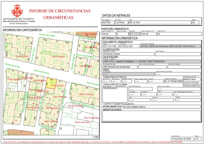
You can also read