Monthly eNewsletter February 2021
←
→
Page content transcription
If your browser does not render page correctly, please read the page content below
February 2021

Monthly eNewsletter
February 2021
                Hi everyone,

                Welcome to the first eNewsletter for 2021. A County Down theme
                seems to have developed in this issue, with a tour of tower houses
                in Lecale and a series of field reports about newly identified sites.
                We also have a selection of new books, some of which are freely
                available online.

                In January, we successfully hosted our first virtual lecture. It is now
                up on our YouTube channel if you missed it. We have also put
                together a programme of lectures for the rest of the year, with some
                great topics. You’ll also have received notice of the AGM in the last
                printed Newsletter and further details will be circulated by email. It
                would be great to see more members join us for our first virtual
                AGM.

                Best wishes,

                Duncan

                Editor

                NI Charity NIC101151                                                    1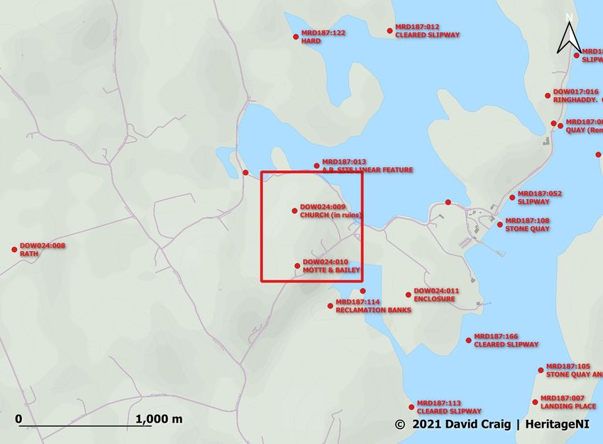
February 2021

     Lectures 2021
     We now have a programme for lectures for 2021. Zoom links will be
     emailed out to members and anyone can watch on our public
     YouTube channel - https://www.youtube.com/channel/
     UC_axPKzQwK60Pm6VOQUgLTw

      29 March         Rethinking Early Medieval Whithorn and the
                       Conversion to Christianity in Scotland
                       Dr Adrián Maldonado, National Museums Scotland

      26 April         The Life and Times of Takabuti in Ancient Egypt
                       and in Belfast
                       Professor Eileen Murphy, QUB

      31 May           Take me to church. A look at two Early Medieval
                       enclosed settlements in County Armagh and their
                       associations with early church sites
                       Gavin Donaghy, Northern Archaeological
                       Consultancy Ltd

      28 June          An update on the ndings of the 2018-19
                       Downpatrick Cathedral Hill excavations
                       Brian Sloan, QUB

      27               Movements and connections between Ireland and
      September        Scotland (and beyond!), from around 4000 BC to
                       around 1500 BC
                       Dr Alison Sheridan, National Museums Scotland

      25 October       The transitory character of society in Gaelic Ulster
                       Dr Katharine Simms, Trinity College Dublin

       6 December      Reconstructing Ireland’s Castles: An Archaeological
                       Interpretation of the Environs of the Irish Tower-
                       House
                       Dr Michael O’Mahony, Queen’s University Belfast

     NI Charity NIC101151                                                     2
fi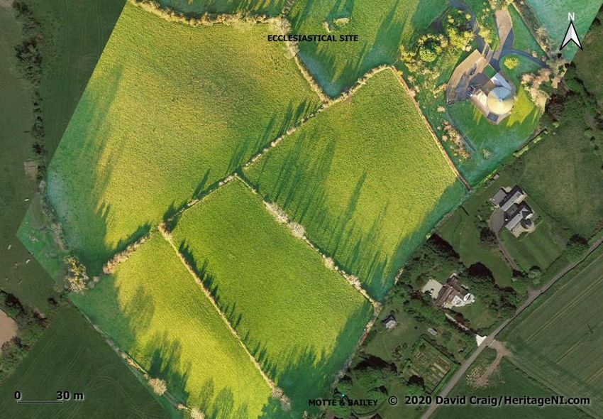
February 2021

A Tour of Tower Houses in Lecale

I mentioned in a previous eNewsletter that I was working on a few
research projects and I’d share them with you in the future. One part
of this has been putting together a small virtual tour of tower
houses in Lecale. I hope to create more tours in the future. I had
intended to include some videos, but the continuing lockdown has
prevented me getting out to the sites to record videos or take more
photographs. Hopefully I can add more images in the future.

As many of you will know, the Lecale area has a large number of
tower houses in scenic locations. They form a very interesting
group, as they are predominantly found by the coast and have a few
unique architectural designs.

You can access the tour through my blog - https://
medievalbuildings.wordpress.com/2021/02/05/tower-houses-of-
lecale-a-tour/

NI Charity NIC101151                                               3
February 2021

Recent Discoveries in County
Down

What follows are three reports on recent field investigations carried
out by David Craig. These are summary reports of sites identified
while working around Strangford Lough and with the local
communities.

                                                           David Craig

                                                      HeritageNI.com

Ballymorran, Castle Field

Irish Grid Reference: J 52639 59710
Summary: A field known as the Castle Field in front of Ballymorran
House in the townland of Ballymorran near Killinchy, County Down
was drone mapped using photogrammetry. The field contains a
small hillock with a lower flat ridge extending to the East. Soil and
crop marks were identified from Google Earth Pro that would
indicate possible underlying structures. 2 square marks were
identified in several flight datasets from Google Earth Pro. A
halfpenny was found dating to 1190-1198. Two other later coins
were also found. This is a possible site of Ballymorran Castle, which
is known to have existed but is un-located. Many thanks to the
landowners for their assistance and enthusiasm in compiling this
project.

Description

PlacnamesNI.org entry for Ballymorran states:

“Ballymorran lies east of Killinchy (church) townland, on the shore of
Strangford Lough. The personal name Morand is well-known in
early Irish literature from a legendary druid or judge who was
credited with a list of maxims advising how a king should rule
properly. No doubt because of this association with ‘natural’
wisdom, Morand, later spelled Morann, was also used by Christian
clerics such as Morand, bishop of Nendrum who died in AD 684
and Morann mac Indrechtaig, abbot of Clogher, who died in AD
NI Charity NIC101151                                                    4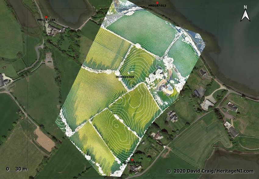
Map Data: OCM Landscape

                Description                                                                                                 February 2021
                PlaacnamesNI.org entry for Ballymorran states:

                “Ballymorran lies east of Killinchy (church) townland, on the shore of Strangford Lough. The personal
                                      842 (AI).in early
                name Morand is well-known         The Irish
                                                         monastery
                                                              literatureof   Nendrum
                                                                          from    a legendaryondruid
                                                                                                 Mahee      Island
                                                                                                     or judge       is a credited
                                                                                                               who was   short
                with a list of maxims advising how a king should rule properly. No doubt because of this association
                                      distance to the north of Ballymorran, and it seems likely that
                with ‘natural’ wisdom, Morand, later spelled Morann, was also used by Christian clerics such as Morand,
                bishop of Nendrum Ballymorran
                                      who died in AD is684named      frommac
                                                            and Morann       theIndrechtaig,
                                                                                    7th-century     bishop,
                                                                                                abbot           especially
                                                                                                       of Clogher, who died as   his
                                                                                                                             in AD
                                      nameof also
                842 (AI). The monastery             appears
                                               Nendrum           in the
                                                          on Mahee        fullis name
                                                                      Island              of the parish
                                                                                  a short distance          of Kilmore
                                                                                                   to the north           ‘big
                                                                                                                 of Ballymorran,
                                                                                 th
                and it seems likely
                 Ballymorran,        that
                                Castle    Ballymorran
                                       Field            is named from the 7 -century bishop, especially as his name also
                                             Investigation
                                      church of Morann’ a few miles inland.”
                appears in the full name of the parish of Kilmore ‘big church of Morann’ a few miles inland.”

Hillshade
created from
DEM with 0.5m
contours
showing the
hillock

                       Map Data: © 2021 HeritageNI

                                                                                                                            Map Data: Google
                 2: Enhanced image from the Google Earth Pro May 2018 dataset
                1: Hillshade created from Digital Elevation Model (DEM) with 0.5m contours showing the hillock

                 © David Craig | HeritageNI.com                                                                                  3|Page

0.5m contours
superimposed
on the Google
Earth image

                                                                                                                 Map Data: Google, HeritageNI
                 3: 0.5m contours superimposed on the Google Earth image

                © 2021 David Craig |NI Charity NIC101151
                                     HeritageNI                                                                                    4 | P a g e5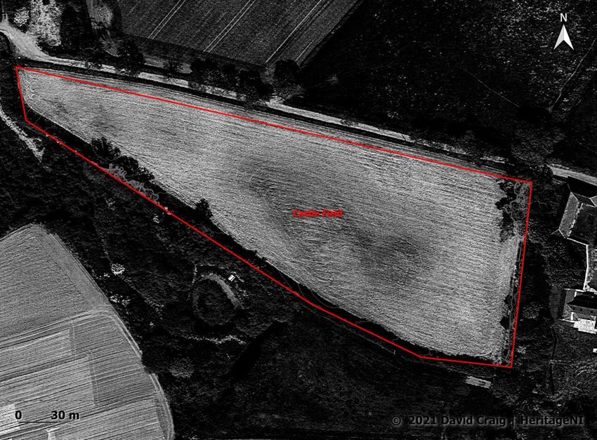
February 2021

                                                                                               Map Data: © 2020 Google / CNES / Airbus
4: September 2019 enhanced Google Earth Pro Imagery showing grass marks

                                         © 2021 David Craig | HeritageNI
                                                                                                  Map Data: © 2021 HeritageNI, Mapbox
Field boundary
 5: (above) Field boundary wall, Well faced on both sides, 1.4m wide.
wall. Well faced               This wall may be part of a building or associated with the existing
 This
on    wall
   both    may
             be part of a building or associated with the existing farm building complex, however no mortar
        sides.
 was wide
1.4m observed.                 farm building complex, however no mortar was observed.

An attempt was made to extrapolateAn attempt
                                         the fieldwas  madeintoorder
                                                   boundary       extrapolate
                                                                       to ascertaintheiffield boundary
                                                                                         a ‘parcel’ of land in
                                                                                                             or order
                                                                                                                a     to
carucate could be identified that   may haveifbeen
                                  ascertain           associated
                                                 a ‘parcel’       withor
                                                            of land     the
                                                                          a location
                                                                            carucateofcould
                                                                                          the Castle  Field.
                                                                                                 be identified     that
The carucate was a medieval unit of land area approximating the land a plough team of
                                  may have been associated with the location of the Castle Field. The
eight oxen could till in a single annual season and approximated to 100-120 acres.
                                  carucate was a medieval unit of land area approximating the land a
The photo was taken at the blueplough
                                    dot (below).
                                           teamThe     yellowoxen
                                                    of eight  line follows
                                                                    couldexisting
                                                                             till in afield boundaries
                                                                                       single             The red lines
                                                                                                annual season      and
are the existing townland boundaries. Two possible carucates of land were identified that could be related
                                  approximated to 100-120 acres.
to the Castle Field. The area north of the line is 126 acres while the area to the south of the line is 150 acres
                                       The photo was taken at the blue dot (below). The yellow line follows
                               existing field boundaries The red lines are the existing townland
  © David Craig | HeritageNI.com                                                           5|Page
                               boundaries. Two possible carucates of land were identified that
150 acre                               could be related to the Castle Field. The area north of the line is
possible
carucate south of
                               126 acres while the area to the south of the line is 150 acres.
 Ballymorran,
the line
              Castle Field Investigation

                                                                                                                                         126 acre
                                                                                                                                         possible
                                                                                                                                         carucate north
                                                                                                                                         of the line

 Map Data: © 2021 HeritageNI, Mapbox                            Map Data: © 2021 HeritageNI, Mapbox
 6: 150 acre possible carucate south of the line                7: 126 acre possible carucate north of the line

 The Coins                     NI Charity NIC101151                                                      6
 Many thanks go to the landowners for allowing the coins to be examined. Thanks also to Randal Scott and
 Alan Dunlop for their assessment the coins.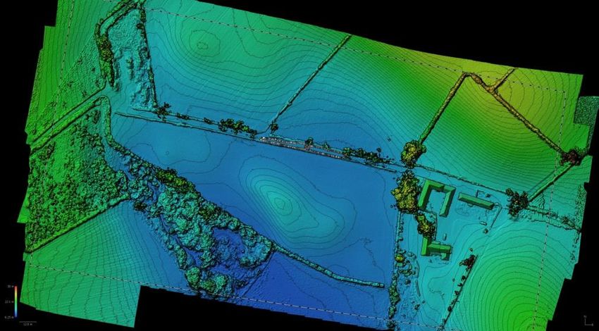
February 2021

                   Map Data: © 2021 HeritageNI, Mapbox                                  Map Data: © 2021 HeritageNI, Mapbox
                   6: 150 acre possible carucate south of the line                     7: 126 acre possible carucate north of the line
                                       The Coins: Many thanks go to the landowners for allowing the coins
                                       to be examined. Thanks also to Randal Scott and Alan Dunlop for
                   The Coins
                                   their assessment the coins.
                   Many thanks go to the landowners for allowing the coins to be examined. Thanks also to Randal Scott and
                   Alan Dunlop for their assessment the coins.

Location of the
coin finds and
other known
features

                                                                                                                        Map Data: HeritageNI, Mapbox, HERoNI
                   8 Location of the coin finds and other known features

                                       A halfpenny of John when Lord of Ireland; voided cross pommee
                                       and annulets; Dublin mint; moneyer Tomas; issued 1190 - 1198.

                  © 2021 David Craig | HeritageNI                                                                                                  6|Page

                                                                                   © 2021 HeritageNI                                         © 2021 HeritageNI

                                       9: Coin 1, Halfpenny, John Lord of Ireland 1290 - 1298

                                       An   interesting
                                       A halfpenny           example
                                                   of John when             andvoided
                                                                Lord of Ireland; stillcross
                                                                                       subject
                                                                                            pommeeto
                                                                                                   anddebate      in Irish
                                                                                                       annulets; Dublin mint; moneyer Tomas;
                                       issued 1190 - 1198.
                                       numismatics. This could well be the cut down centre of a Henry VI
                                       groat. These "coins" were valued as pennies and are known to have
                                       circulated in Ireland during the mid 15th century. Henry groats were
                                       issued in England from 1422 - 1461.

                                       The thickness of the coin would be a pointer as to its origin. The
                                       "defacing" on one side is thought to result from die clash.
                                                                                     © 2021 HeritageNI                         © 2021 HeritageNI
                                       NI Charity NIC101151                                                                                                      7
                                       10: Coin 2, Possible cut down Henry VI groat, 1422 - 1461

                                        An interesting example and still subject to debate in Irish numismatics. This could well be the cut down
                                       centre of a Henry VI groat. These "coins" were valued as pennies and are known to have circulated in Ireland
                                       during the mid 15th century. Henry groats were issued in England from 1422 - 1461.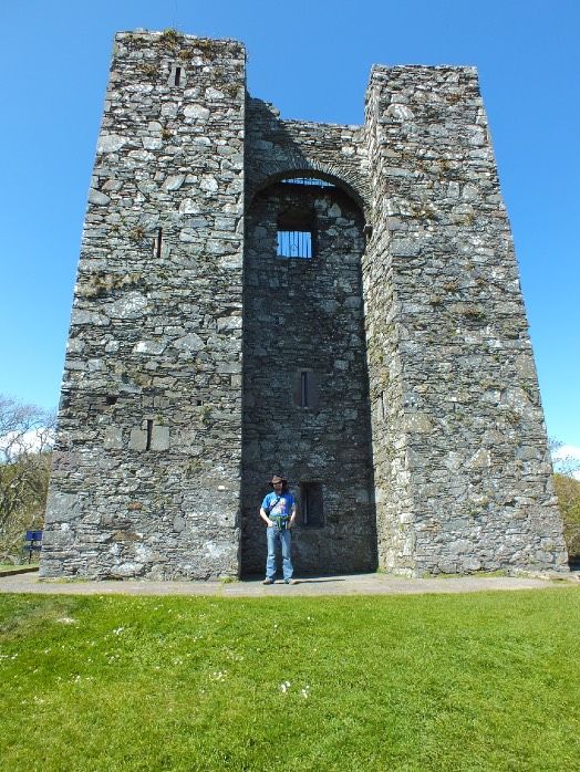
© 2021 HeritageNI                                                          © 2021 HeritageNI

     9: Coin 1, Halfpenny, John Lord of Ireland 1290 - 1298
                                                                                                             February 2021
     A halfpenny of John when Lord of Ireland; voided cross pommee and annulets; Dublin mint; moneyer Tomas;
     issued 1190 - 1198.

                                                      © 2021 HeritageNI                                       © 2021 HeritageNI

     10: Coin 2, Possible cut down Henry VI groat, 1422 - 1461
 AAncut  penny (ie halfpenny) of Henry III; long cross; London mint;
     interesting example and still subject to debate in Irish numismatics. This could well be the cut down
 type
  centreV;
        of amay
             Henrybe   moneyer
                   VI groat.        Willem;
                             These "coins" were issued
                                                valued as 1247
                                                          pennies-and
                                                                   1272.    Multiple
                                                                      are known to havecut
                                                                                        circulated in Ireland
     during the mid 15th century. Henry groats were issued in England from 1422 - 1461.
 mark attempts are visible.
  The thickness
 Ballymorran,   of the
              Castle    coin
                     Field   would be a pointer as to its origin. The "defacing" on one side is thought to result
                           Investigation
     from die clash.

      © David Craig | HeritageNI.com                                                                                                    7|Page

                                         © 2021 HeritageNI                                                      © 2021 HeritageNI

 11; Coin 3, Cut penny, Henry III 1247-1272
 Discussion
 A cut penny (ie halfpenny) of Henty III; long cross; London mint; type V; may be moneyer Willem; issued
 1247 - 1272. Multiple cut mark attempts are visible.
 Burkes Peerage1 has this entry “Walter Whyte with several of his
 Discussion
 brothers,
 Burkes  Peerageaccompanied
                 1
                                        Strongbow
                   has this entry “Walter                  on his
                                          Whyte with several     of hisexpedition     to Ireland
                                                                       brothers, accompanied          inon his
                                                                                              Strongbow
 expedition to Ireland in 1170 and was knighted by Henry II in Dublin 1171. He accompanied John de Courcy to
 1170 andin was
 Downpatrick            knighted
                 1177 and               bya leading
                             having taken    HenrypartII inintheDublin
                                                                 subsequent1171.    Heof Ulster
                                                                             conquest    accompanied
                                                                                                was rewarded
 John de Courcy to Downpatrick in 1177 and having taken a leading
 with large grants of land on the west shore of Strangford Lough. He was one of the five barons of Ulster
 created by de Courcy as Earl Palatine of Ulster. His descendants were known as the Lords of Duffrye and built
 part in
 castles     the subsequent
         at Ballymorran,               conquest
                          Killinchy, Raynhaddye       of Ulster
                                                 and Ring   dufferin" was rewarded with large

 grants
 There      ofa land
       is also         ontothe
                reference        west
                            Sir Walter   shore
                                       Whytes      of Strangford
                                               grandson                 Lough.
                                                        Sir Balthazar Whyte      He was
                                                                            who supported   one
                                                                                          John during his
 expedition to Ireland when he stayed at Ballymorran Castle in July 1210.
 of the five barons of Ulster created by de Courcy as Earl Palatine of
 In The Vassels of the Earls of Ulster 2 Lawlor states “The territory of Ballymorran, now merely one td., lies
 Ulster. His descendants were known as the Lords of Duffrye and
 north of the barony of Dufferin; there is no sign of a mote-castle in the present td., but just outside it is a
 builtbeside
 mote    castles     at Ballymorran,
              an ancient church-ruin, knownKillinchy,
                                               as Rath Gorman.Raynhaddye           and
                                                                  A castle, doubtless    Ringbretesche, still
                                                                                      a wooden
 survived here in 1600, and it was apparently here that King- John stayed a night on his return journey from
 dufferin" in 1210.”
 Carrickfergus

 Until now there has been no other candidate for Ballymorran Castle apart from the Motte at Rathgorman
 There is also a reference to Sir Walter Whyte’s grandson Sir
 2.7km to the south.
 Balthazar Whyte who supported John during his expedition to
 Ballymorran townland may have once been larger than it is now.
 Ireland when he stayed at Ballymorran Castle in July 1210.
 1
  Taken from Burkes Genealogical & Heraldic History 4th Edition 1958: pp.762/63 Lineage- the following is derived partly from a
 pedigree registered in Ulster Office 1765 (Gen. Off. Dublin Castle MS 165 Reg. Peds. Vol II, pp14-20)
 NI Charity NIC101151
 2                                                                                                                                  8
  The Vassals of the Earls of Ulster Author(s): H. C. Lawlor Source: Ulster Journal of Archaeology , 1940, Third Series, Vol. 3 (1940), pp.
 16-26 Published by: Ulster Archaeological Society

© 2021 David Craig | HeritageNI                                                                                              8|Page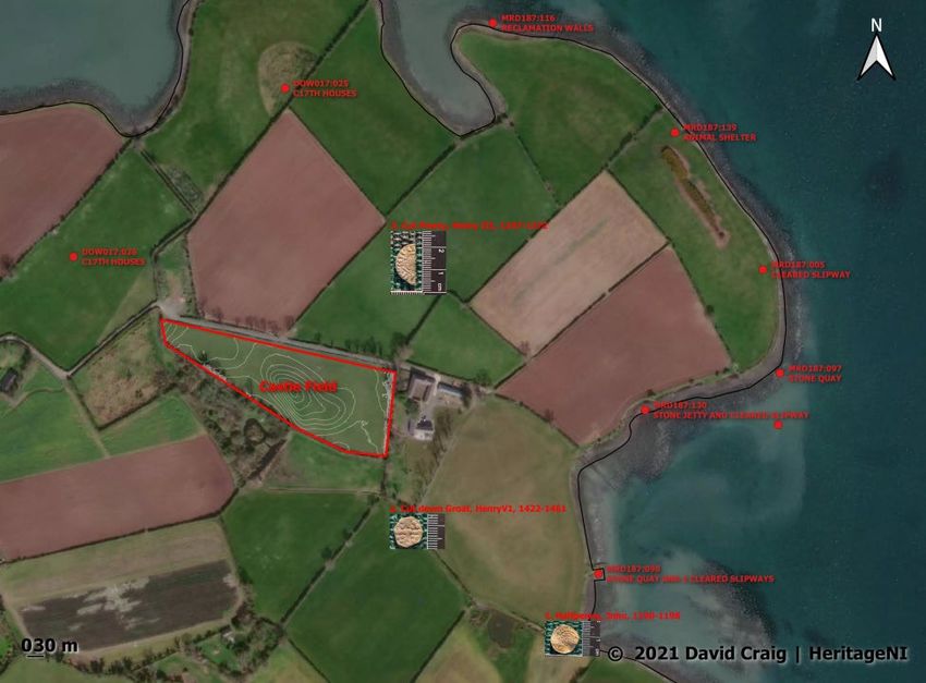
February 2021
In The Vassels of the Earls of Ulster Lawlor states “The territory of
Ballymorran, now merely one td., lies north of the barony of
Dufferin; there is no sign of a mote-castle in the present td., but just
outside it is a mote beside an ancient church-ruin, known as Rath
Gorman. A castle, doubtless a wooden bretesche, still survived here
in 1600, and it was apparently here that King John stayed a night on
his return journey from Carrickfergus in 1210.” (UJA 3, 1940, 16-26)
Until now there has been no other candidate for Ballymorran Castle
apart from the Motte at Rathgorman 2.7km to the south.
Ballymorran townland may have once been larger than it is now.
The hillock in front of Ballymorran house looks like it had a structural
Location
It is situatedfeature
on privateon
landitinatthe
one timeofgoing
townland by the
Ballymorran soil
in the marks.
parish There
of Killinchy is no
in the strong
baronry of
evidence for a ditch, however rainwater does lie around the base of
Dufferin. Thanks to the landowners for their assistance and for allowing the survey to take place.
the hillock in places in a slight depression.
In the 1960s the top of the hillock was levelled substantially to aid
farming. The original height is not known.
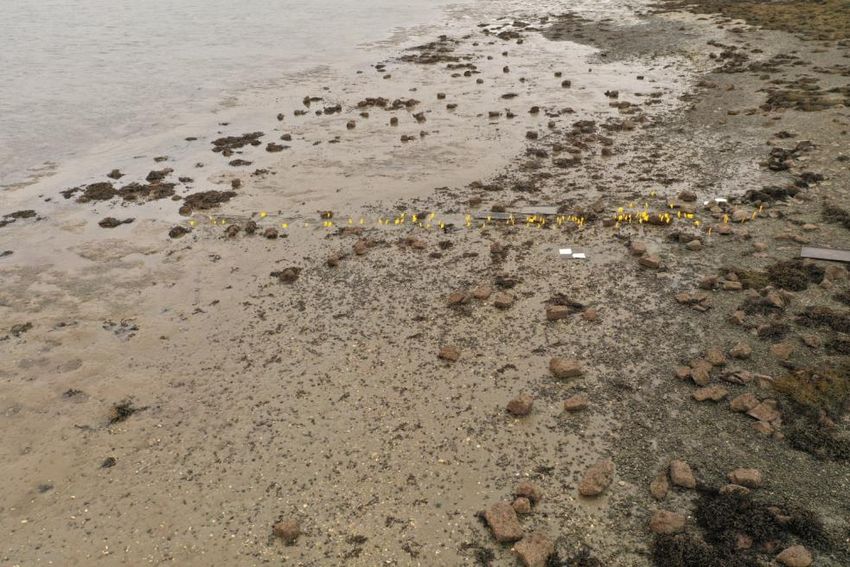
Ballymorran Multiple Linear Wooden Post Feature
Irish Grid Reference: J 53026 59986
Summary: A clustered line of 120 posts between high and low
water mark at approximately right angles to the shore.
1 Location in Northern Ireland
2 Local locationNI Charity NIC101151 9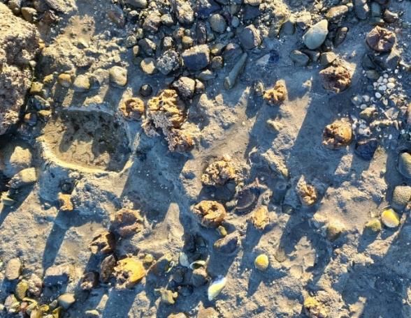
February 2021

               Ballymorran Multiple Linear Wooden Post Feature

                                Description

                                The length of the array of unworked posts extends to 13.57m and
                                0.94m at its widest. The mean diameter of the posts is 4.32cm. They
                                start at approximately 18.8m from the high tide mark and extend to
                                38.2m from the high tide mark. In some cases there are 2 posts side
                                by side. They do not appear to go beyond low tide mark. There is
                                one other post 92m to the north and 2 posts to the south, 20m and
                                30m from the main feature. There is no corresponding field
                                boundary in any of the Historical 6” maps. There is a small slightly
                                raised 3m x 4m platform on the raised beach opposite the feature.
                                Ballymorran Multiple Linear Wooden Post Feature

View of the
locations of the
posts, marked by
yellow flags

               Description
               The length of the array of unworked posts extends to 13.57m and 0.94m at its widest. The mean diameter of
               the posts is 4.32cm. They start at approximately 18.8m from the high tide mark and extend to 38.2m from
               the high tide mark. In some cases there are 2 posts side by side. They do not appear to go beyond low tide
               mark. There is one other post 92m to the north and 2 posts to the south, 20m and 30m from the main
               feature. There is no corresponding field boundary in any of the Historical 6” maps. There is a small slightly
               raised 3m x4m platform     on the raised beach opposite the feature.
                                 Description
                                The length of the array of unworked posts extends to 13.57m and 0.94m at its widest. The mean diameter of
                                the posts is 4.32cm. They start at approximately 18.8m from the high tide mark and extend to 38.2m from
                                the high tide mark. In some cases there are 2 posts side by side. They do not appear to go beyond low tide
                                mark. There is one other post 92m to the north and 2 posts to the south, 20m and 30m from the main
                                feature. There is no corresponding field boundary in any of the Historical 6” maps. There is a small slightly
Typical above
                                raised 3m x4m platform on the raised beach opposite the feature.
surface view

                                                                          3 Typlcial above surface view
                                                                   3 Typlcial above surface view
                                NI Charity NIC101151                                                                                   10
                               © David Craig | HeritageNI.com                                                                     4|Page

           © David Craig | HeritageNI.com                                                                                                       4|Page
February 2021
Post distribution
4 Post distribution
Data Acquisition
Yellow flags mounted on wire were placed at every post and the area mapped using photogrammetry from a
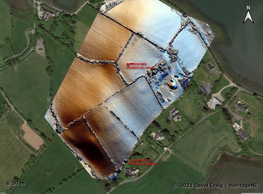
Rathgorman, County
drone. 2 reference points Down
were recorded either side of the post array to 2cm accuracy using RTK-GPS.
Irish Grid Reference: J 52718 58434
Appendix
Summary: An areaMethodology
Drone Data Acquisition of the townland of Rathgorman was aerial
The drone used was a DJI Mavic Pro 2 with a 20mp Hasselblad camera. Multiple overlapping images were
surveyed to try and identify if there was any other features in the
acquired using the automated capture software MapPilot and flown autonomously. 16 photographs were
vicinity
taken nadirof the late
to create a singlemedieval
georeferencedchurch (DOW024:009)
photogrammetry and
dataset that is 8876 thepixels.
x 9152 Motte The ground
sample distance (GSD) is 2.54mm/pixel at an AGL of 7m.
and Bailey (DOW024:010). Associated features were identified by
Data Processing and Presentation
using Drone
The images photogrammetry
were processed to create
through the photogrammetry anda3dgeoreferenced
modelling software, Agisoft Metashape
Pro. The resulting geoTIFF image was further processed through the Camera Raw plugin in Adobe Photoshop
orthomosaic, contours, and a multi-directional Hillshade from a
and the colours adjusted using a custom filter to create the enhanced black and white image. A Digital
Digital Elevation
Elevation Model (DEM) fileModel (DEM).
was also created Supplementary
and processed features
through the DEM enhancingwere
software Relief
identified from grass/crop marks from Google Earth Pro imagery.
The main new features identified was:
The
© David• Craig rath in the
| HeritageNI.com townland name was located along with 5 | P a g e
possible associated field enclosures.
• A second larger circular enclosure was also identified in the
field west of the church.
• An approach laneway leading up to the bailey from the
West.
NI Charity NIC101151 11February 2021
Figure 1 Location
Feature Identi cation
Feature Identification
The
The aerial survey was aerial survey
undertaken on 30th was undertaken
Dec 2020 on 30th Dec
with kind permission from 2020 with kind
the landowner.
permission
Two circular enclosures fromfrom
were identified the the
landowner.
georeferenced orthomosaic. The larger enclosure being 35m
across and is on a westward facing slope. It is suggested that this is possibly a ring barrow although
Twois circular
indeterminate as there no featureenclosures
topography. were identified
The smaller from theisgeoreferenced
hilltop enclosure suggested as the rath and is
approximately 22.8m orthomosaic. The
across. The field largertoenclosure
boundary being 35m
its north is respecting the across and ofisthe
curving edge onrath.
a It is
not easily seen in the orthomossaic but is more noticeable in the multi-directional hillshade in Figure 4
westward facing slope. It is suggested that this is possibly a ring
barrow although indeterminate as there is no feature topography.
© David Craig | HeritageNI.com 3|Page
The smaller hilltop enclosure is suggested as the rath and is
approximately 22.8m across. The field boundary to its north is
respecting the curving edge of the rath. It is not easily seen in the
orthomosaic but is more noticeable in the multi-directional hillshade
below.
From the Multi-directional hillshade there seems to be a trackway (1)
showing as 2 parallel banks leading up to the Bailey (DOW024:010).
This heads off in a North-West direction.
At the northern end of same field there is a rectilinear platform 70m
x 52m. At the southern end of the same field there is faint evidence
of a ditch around the Bailey.
NI Charity NIC101151 12
fiFebruary 2021
Rathgorman, County Down
Rathgorman, County Down
Orthomosaic
showing rath and
enclosure
locations
Figure 2: Orthomosaic showing rath and enclosure locations
Figure 2: Orthomosaic showing rath and enclosure locations
0.5m contours
from the DEM
overlaid on the
orthomosaic
Figure 3: 0.5m Contours from the Digital Elevation Model (DEM) overlaid on the orthomosaic
Belowfrom
Figure 3: 0.5m Contours is an
the enhanced
Digital Elevationblack
Model and
(DEM) white
overlaid image from a
on the orthomosaic Google Earth
Pro dataset from June 2010. The image has been specifically
processed to show grass colour differentiation. The rath can be
© David Craig | HeritageNI.com 4|Page
clearly
© David Craig identified. This field and the church field to the north also
| HeritageNI.com 4|Page
shows darker crop marks indicating other possible enclosures.
NI Charity NIC101151 13February 2021
Rathgorman, County Down
Multi-directional
hillshade created
from a DEM from
drone acquired
Rath
imagery showing
the rath
(1)
Figure 4: Multi-directional hillshade created from a DEM from drone acquired imagery showing the rath.
None of these features correlate to any feature on the Historic 6”
From the Multi-directional hillshade there seems to be a trackway (1) showing as 2 parallel banks leading up
maps.
to the Bailey (DOW024:010). This heads off in a North-West direction.
A end
At the northern rotatable 360there
of same field degree panorama
is a rectilinear taken
platform 70m from
x 52m 120m (400ft) can be
viewed at: https://heritageNI.com/panos/rathgorman
At the southernRathgorman,
end of theCounty
sameDown
field there is faint evidence of a ditch around the bailey
Figure 7 is an enhanced black and white image from a Google Earth Pro dataset from June 2010. The image
has been specifically processed to show grass colour differentiation. The rath can be clearly identified. This
Grass colour
field and the church field to the north also shows darker crop marks indicating other possible enclosures.
differential
None of these features correlate to any feature on the Historic 6” maps.
showing
additional
A rotatable 360 degree panorama taken from 120m (400ft) can be viewed at:
enclosures and
https://heritageNI.com/panos/rathgorman
the rath (Google
Earth 2010)
Rath
© David Craig | HeritageNI.com 5|Page
NIFigure
Charity NIC101151
5: Grass colour differential showing additional enclosures and the Rath (Google Earth 2010)
14February 2021 Online Activities This month I have two books to offer you as online activities. The first is: Window to the West: Culture and Environment in the Scottish Gàidhealtachd This book asks whether there is anything distinctive about how the Gaels through the ages have looked at the world. The authors begin by considering how sight – and the lack of it – have been valued in Gaelic culture, how colour is represented in the language and how visual cues such as shape and pattern have generated Gaelic vocabulary. They investigate the stances embedded in Gaelic grammar and idiom and how these are made explicit in folklore, poetry and the thinking of Gaelic theologians. The recurrence of certain features is traced in the artefacts of the Gaels, in their buildings, metal-work, stone carving and manuscripts. These are seen to exhibit aesthetic trends towards abstraction, circularity, number symbolism, dynamism and interweaving – the same aesthetic that may be seen to underlie certain forms of poetry, dance and ceòl-mòr. Can such structures be seen to relate to cultural attitudes expressed in the language? The authors believe that they can, and propose a tenacious ‘way of seeing’ among the Gaels, which shaped and in turn was shaped by fundamental perceptions of mankind’s position in the environment, of the shape of time, and of the relationship between the spirit and the material. https://pure.uhi.ac.uk/en/publications/window-to-the-west-culture- and-environment-in-the-scottish-gàidhe The second is: Bog bodies: Face to face with the past The ‘bog bodies’ of north-western Europe have captured the imagination of poets as much as archaeologists, confronting us with human remains where time has stopped – allowing us to come ‘face to face’ with individuals from the past. Their exceptional preservation allows us to examine unprecedented details of both NI Charity NIC101151 15
February 2021

their lives and deaths, making us reflect poignantly upon our own
mortality. Yet this book argues that they must be resituated within a
turbulent world of endemic violence and change, reinterpreting the
latest Continental research and new discoveries in this light. The
book features a ground-breaking ‘cold case’ forensic study of
Worsley Man: Manchester Museum’s ‘bog head’ and brings the
bogs to life through both natural history and folklore, as places that
were rich, fertile, yet dangerous. Finally, it argues that these remains
do not just pose practical conservation problems but philosophical
dilemmas, compounded by the critical debate on if – and how –
they should be displayed, with museum exemplars drawn from
across the globe.

https://www.manchesteropenhive.com/view/
9781526150196/9781526150196.xml?
rskey=uWAQIU&result=2&fbclid=IwAR3M41e3q4EBd49vSXDZCCK
4EI5w7JnOPMH5Zbyvlb6y8My30hGNLL-m-hE

NI Charity NIC101151                                                  16
February 2021

New Books

Irish Country Furniture and Furnishings 1700-2000 - Claudia
Kinmonth

Cork University Press, £35

This is a beautiful book, with extensive illustrations of Irish furniture
in a range of settings. Each chapter examines a different type of
furniture within the home, from seats and beds to the smaller
utensils and house shrines. The detailed discussion paints a vivid
picture of how the Irish vernacular house would have appeared. But
the book goes beyond this, giving us a social history of these
houses and objects. The introduction discusses how society and
environment shaped the vernacular house. Throughout the book,
the form and use of furniture is explained in relation to its social,
economic, and environmental context. A book covering the 18th to
21st centuries may seem a little modern to be considered
archaeology, but this furniture has similarities to predecessors and it
is a disappearing part of our history that needs to be studied. This
book will be of great value to anyone interested in Irish rural society
from the Middle Ages to the present.

The Plight of the Big House in Northern Ireland - J.A.K. Dean

Ulster Architectural Heritage, £24

The big houses of Northern Ireland have been suffering decline and
neglect for many years, and this book gives us an illustration of that
loss. Organised by county, this is primarily a gazetteer of the big
houses that have been lost or decayed. Each entry has some history
and information about the house and most are illustrated. The
introduction discusses the architectural styles of the buildings and
the social context of their creation and decline. There are photos of
how houses such as Downhill and Mount Panther appeared before
they fell into ruin. It is also interesting to see images of places such
as Belvoir Park and Castlewellan Cottage, which have now been lost
but their demesne survives. This is a very interesting book and many
readers will enjoy finding out about lost houses in locations they
often visit and where they live.

NI Charity NIC101151                                                   17
You can also read