Monthly overview - Manstrat AIS
←
→
Page content transcription
If your browser does not render page correctly, please read the page content below
Monthly overview
February 2018 turned out to be the wettest month of the summer rainfall season. Widespread rain fell over
large parts of the country with northern Limpopo registering the highest rainfall figures. During the first ten
days of February thunderstorms brought good rains to large parts of the region (Bloemfontein and Pretoria
40 mm each), with as much as 80mm on a Hartbeesfontein farm in North West during one such storm.
During the second ten days of the month, rainfall mainly occurred over the central regions of the country with
isolated showers over the rest of the summer rainfall region. Between 40 to 100 mm were recorded in Free
State (Rouxville area), and at Gariep Dam (91 mm). Rare thunderstorms in Cape Town, also brought some
welcome relief. During the end of this ten day period rainfall shifted to the north and east of the country.
On 20 February Limpopo (109 mm and Tzaneen 134 mm), and northern KwaZulu-Natal (Richards Bay 50 mm
to 80 mm) reported good rains and the Hluhluwe dam started to overflow as a result of good rains. During the
last 8 days of the month, rain fell mainly over Limpopo and the north Eastern Cape and southern KwaZulu-
Natal. Rainfall in Mpumalanga - Sabie, Mbombela and Phalaborwa - measured between 50 and 60 mm, while
KwaZulu-Natal - Pongola (100 mm) and Estcourt (112 mm) also receiving their fare share. In the Eastern
Cape, Coffee Bay recorded the highest rainfall (133 mm) during the period.

Rainfall
The highest accumulated rainfall fell over the north eastern Free State, north western Eastern Cape, southern
Gauteng and northern Limpopo during the period.

Figure 1: Total
rainfall estimation
in millimetres for
1 to 28 February
2018
Figure 2:
                                                                                            Percentage
                                                                                            difference -
                                                                                            rainfall for
                                                                                            1-28 February
                                                                                            2018.

Figure 2 gives a perspective for February: Areas that received above normal rainfall are indicated in green
and blue. Normal to above-normal rainfall fell over parts of the Western Cape, southern Northern Cape,
most of the Eastern Cape, northern Free State, central and northern KwaZulu-Natal as well as Limpopo.

Figure 3:
Cumulative
rainfall from
1 September 2017
to 28 February
2018 in millime-
tres.

             This cumulative rainfall map (Figure 3) for 1 September to 28 February highlights the areas
             that received more than 150 mm during the period: Light green indicates areas receiving be-
             tween 150 and 200 mm; dark green indicates areas receiving between 200 and 300 mm; and
             areas that received more than 400 mm, are indicated in blue.
Figure 4:
Percentage
difference -
rainfall for
1 September2017
to 28 February
2018.
Figure 4 highlights those areas that received below-normal and above-normal rainfall during the last 6
months. Yellow to light brown show areas of concern, while isolated areas throughout the country high-
lighted in green, received above normal rainfall during the last 6 months. Overall, most areas of the sum-
mer rainfall region have received between 75 to 100% of the normal expected rainfall this season.
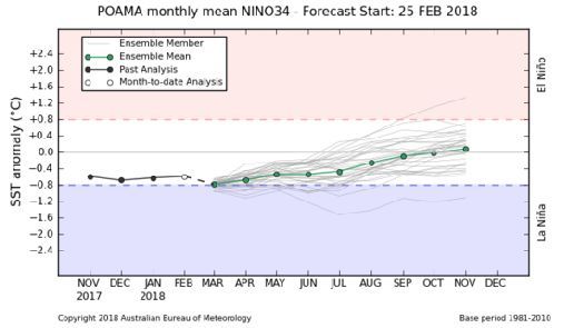
El Nino/La Nina
Background: Periods of below normal rainfall in South Africa are often linked with the El Nino event
while above normal rainfall is linked to La Nina. The latest predictions issued by the Australian Bureau of
Meteorology indicate neutral conditions (Figure 5). Despite cooling of the pacific ocean, La Nina condi-
tions haven’t been reached. Pacific Ocean temperatures expected to increase during the autumn months.
Figure 5: Current
model predictions
for Sea Surface
Temperature in
the Pacific.
Figure 6: Current
model predictions
for rainfall during
Figure 6 show the expected rain- February 2018
fall for March 2018 as calculated
from the NOAA Climate Forecast system. Areas
in blue highlight above-normal rainfall while the
areas in red highlight below-normal rainfall. Beige
highlights areas receiving normal rainfall. A dry
start to Autumn is expected for the country with
only the northern Eastern Cape, KwaZulu-Natal
and parts of Mpumalanga expected to receive nor-
mal to above-normal rainfall.NDVI
Figure 7:
ProbaV difference
map for
February 2018
compared to the
long-term
(20-year)
average.
Figure 7: This map is created by calculating the difference between February 2018 and the long-term (20-year)
average for February - showing dominant normal vegetation activity (beige). The Limpopo Province shows below-
normal vegetation activity, but this might be the result of cloud cover since the province received good rainfall in
February. The March NDVI image should reflect the effect of the rainfall. The rest of the summer rainfall region
show normal to above normal vegetation conditions as a result of the good rainfall in February.
Figure 8:
Percentage of
Average Seasonal
Greenness for the
last 6 months
ending in
February 2018.
Drought is a long-term phenomenon. Focusing on longer time-periods is a more reliable
method to monitor and map drought. Areas of concern include the Western Cape, western
Eastern Cape, western & southern Northern Cape and the Free State. Conditions remain neu-
tral over most of the summer rainfall region.General Discussion
Figure 9: South African dam levels between February 2018 and March 2018
The good rains in the northern parts of the country supports an optimistic prognosis for the current season’s crops,
particularly in Limpopo province. The harvest of avocados has started in the Mooketsi and Levubu areas. It is esti-
mated that total exports will be up to 50% higher than last year’s drought-affected crop. The bulk of the avocado
crop is exported to the European Union where demand is increasing. Other export avenues, such as China, are also
being explored.
In the south of the country the outlook is less positive. The Western Cape Department of Agriculture economists
estimate a decline of up to R 6.0 billion in income in the agricultural sector for the province. A major consequence
is that about 30 000 jobs could be lost and because many of these workers are semi-skilled or unskilled, reducing
their chances of absorption by other sectors of the economy.
As we head towards autumn, farmers can start to expect the normal changes in vegetative growth with many veld
grasses beginning to seed. Thus nutritional value of natural grazing will begin to decrease especially in sourveld
regions. It is important that animals be in good condition before the winter months - animals that are underweight
before winter when the grasses offer little or no nutrition will lose even more condition and will struggle to regain a
good condition again. Animals in poor condition are less fertile and more susceptible to parasites and diseases. It is
good practice to deworm animals against internal parasites. Local veterinarians will be able to advise on which
parasites are a problem at this time of year, and which products to use.
During late summer and autumn months, Cullicoides midge numbers reach a peak before dropping after the first
frost. These blood sucking midges are important carriers of the African Horse sickness and Bluetongue virus affect-
ing horses and sheep respectively. Unvaccinated animals are especially at risk of contracting these diseases. Farm-
ers can treat shelters and animals with approved insecticides and monitor their animals’ condition daily.
Acknowledgements:
SPOT Vegetation Data: The product was generated by the land service of Copernicus, the Earth
Observation program of the European Commission. The research leading to the current version of the
product has received funding from various European Commission Research and Technical Development
programs. The product is based on VEGETATION data ((c) CNES).
PROBA-V Data: The product was generated by the land service of Copernicus, the Earth Observation
program of the European Commission. The research leading to the current version of the product has
received funding from various European Commission Research and Technical Development programs.
The product is based on PROBA-V data ((c) ESA).
El-Nina/La Nina predictions: POAMA graph provided by courtesy of the Australian Bureau of Meteor-
ology, (c) 2016.
Rainfall Estimation (RFE): Data provided by the National Oceanic and Atmospheric Ad-
ministration (NOAA), Centre for Weather and Climate Prediction. http://www.cpc.noaa.gov/
products/international/data.shtmlYou can also read