New weather radar technology can spot hailstones lurking in thunderstorms - Phys.org
←
→
Page content transcription
If your browser does not render page correctly, please read the page content below
New weather radar technology can spot
hailstones lurking in thunderstorms
28 November 2017, by Joshua Soderholm, Alain Protat, Hamish Mcgowan And Matthew Mason
scans the atmosphere at multiple levels, building a
3-D picture of thunderstorms, with a 2-D version
shown on the bureau's website.
This is particularly important for hail, which forms
several kilometres above ground in towering storms
where temperatures are well below freezing.
UQ mobile radar deployed for thunderstorm monitoring.
Credit: Kathryn Turner
An Australian spring wouldn't be complete without
thunderstorms and a visit to the Australian Bureau
of Meteorology's weather radar website. But a new
type of radar technology is aiming to make weather
radar even more useful, by helping to identify
those storms that are packing hailstones.
Most storms just bring rain, lightning and thunder.
But others can produce hazards including
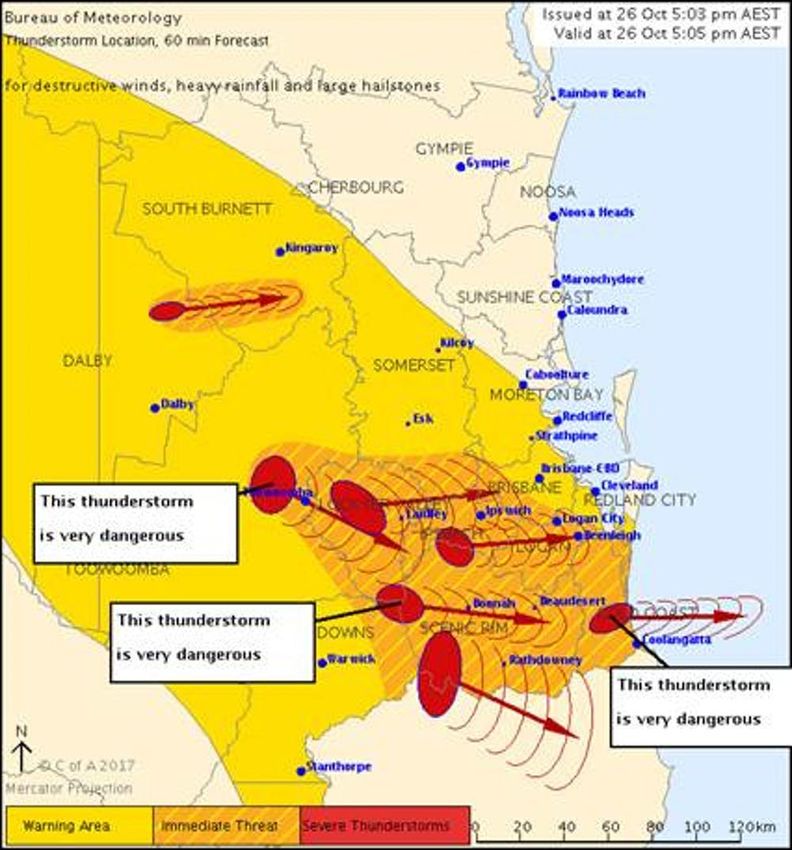
destructive flash flooding, winds, large hail, and Bureau of Meteorology 60-minute nowcast showing
even the occasional tornado. For these potentially location and projected track of severe thunderstorms in
dangerous storms, the Bureau issues severe 10-minute steps. Credit: Australian Bureau of
thunderstorm warnings. Meteorology
For metropolitan regions, warnings identify severe
storm cells and their likely path and hazards. They
provide a predictive "nowcast", such as forecasts In terms of insured losses, hailstorms have caused
up to three hours before impact for suburbs that more insured losses than any other type of severe
are in harm's way. weather events in Australia. Brisbane's November
2014 hailstorms cost an estimated A$1.41 billion,
When monitoring thunderstorms, weather radar is while Sydney's April 1999 hailstorm, at A$4.3 billion
the primary tool for forecasters. Weather radar , remains the nation's most costly natural disaster.
1/4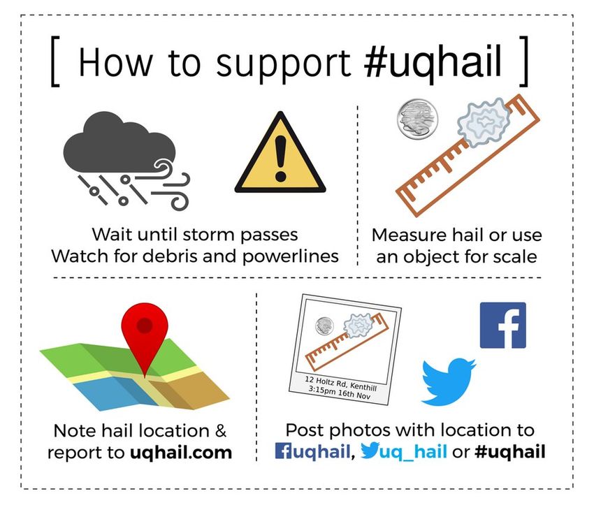
Breaking the ice                                       Instead, researchers resorted to models or historical
                                                        reports.
Nonetheless, accurately detecting and estimating
hail size from weather radar remains a challenge        The Atmospheric Observations Research Group at
for scientists. This challenge stems from the           the University of Queensland (UQ) has developed a
diversity of hail. Hailstones can be large or small,    unique capacity in Australia to deploy mobile
densely or sparsely distributed, mixed with rain, or    weather instrumentation for severe weather
any combination of the above.                           research. In partnership with the UQ Wind
                                                        Research Laboratory, Guy Carpenter and staff in
Conventional radars measure the scattering of the the Bureau of Meteorology's Brisbane office, the
radar beams as they pass through precipitation.         Storms Hazards Testbed has been established to
However, a few large hailstones can look the same advance the nowcasting of hail and wind hazards.
as lots of small ones, making it hard to determine
hailstones' size.                                       Over the next two to three years, the testbed will
                                                        take a mobile weather radar, meteorological
A new type of radar technology called "dual-            balloons, wind measurement towers and hail size
polarisation" or "dual-pol" can solve this problem.     sensors into and around severe thunderstorms.
Rather than using a single radar beam, dual-pol         Data from these instruments provide high-
uses two simultaneous beams aligned horizontally resolution case studies and ground-truth verification
and vertically. When these beams scatter off            data for hazards observed by the Bureau's dual-pol
precipitation, they provide relative measures of        radar.
horizontal and vertical size.
                                                        Since the start of October, we have intercepted and
Therefore, an observer can see the difference           sampled five hailstorms. If you see a convoy of UQ
between flatter shapes of rain droplets and the         vehicles heading for ominous dark clouds, head in
rounder shapes of hailstones. Dual-pol can also         the opposite direction and follow us on Facebook
more accurately measure the size and density of         instead.
rain droplets, and whether it's a mixture or just rain.

Together, these capabilities mean that dual-pol is a
game-changer for hail detection, size estimation
and nowcasting.

Into the eye of the storm

Dual-pol information is now streaming from the
recently upgraded operational radars in Adelaide,
Melbourne, Sydney and Brisbane. It allows
forecasters to detect hail earlier and with more
confidence.

However, more work is needed to accurately
estimate hail size using dual-pol. The ideal place
for such research is undoubtedly southeast
Queensland, the hail capital of the east coast.

When it comes to thunderstorm hazards, nothing is
closer to reality than scientific observations from How to report for uqhail.
within the storm. In the past, this approach was
considered too costly, risky and demanding.

                                                                                                     2/4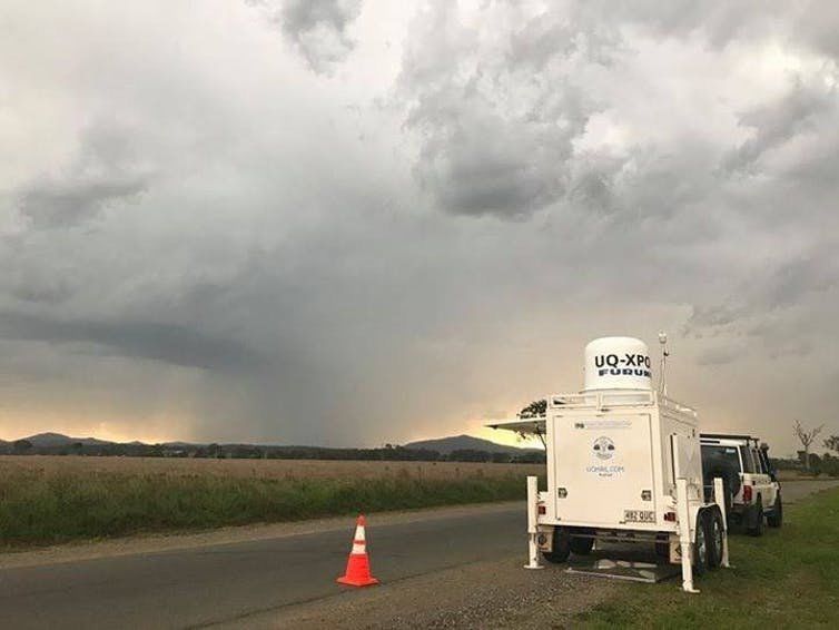
Unfortunately, the UQ storm-chasing team can't get
to every severe thunderstorm, so we need your
help! The project needs citizen scientists in
southeast Queensland to report hail through
#UQhail. Keep a ruler or object for scale (coins are
great) handy and, when a hailstorm has safely
passed, measure the largest hailstone.

Submit reports via uqhail.com, email, Facebook or
Twitter. We greatly appreciate photos with a ruler or
reference object and approximate location of the
hail.

Combining measurements, hail reports and the
Bureau of Meteorology's dual-pol weather radar
data, we are working towards developing
algorithms that will allow hail to be forecast more
accurately. This will provide greater confidence in
warnings and those vital extra few minutes when
cars can be moved out of harm's way, reducing the
impact of storms.

Advanced techniques developed from storm-
chasing and citizen science data will be applied
across the Australian dual-pol radar network in
Sydney, Melbourne and Adelaide.

Who knows, in the future if the Bureau's weather
radar shows a thunderstorm heading your way,
your reports might even have helped to develop
that forecast.

This article was originally published on The
Conversation. Read the original article.

 Provided by The Conversation
APA citation: New weather radar technology can spot hailstones lurking in thunderstorms (2017,
November 28) retrieved 10 July 2019 from https://phys.org/news/2017-11-weather-radar-technology-

                                                                                             3/4
hailstones-lurking.html

                                   This document is subject to copyright. Apart from any fair dealing for the purpose of private study or research, no
                                   part may be reproduced without the written permission. The content is provided for information purposes only.

                                                                                                                                                4/4

Powered by TCPDF (www.tcpdf.org)
You can also read