Daily Operations Briefing - Thursday, August 19, 2021 8:30 a.m. ET - GovDelivery

Page created by Nathan Mccoy
 
CONTINUE READING
Daily Operations Briefing - Thursday, August 19, 2021 8:30 a.m. ET - GovDelivery
FEMA National Watch Center

Daily Operations Briefing
    Thursday, August 19, 2021
             8:30 a.m. ET
Daily Operations Briefing - Thursday, August 19, 2021 8:30 a.m. ET - GovDelivery
National Current Ops / Monitoring
New Significant Incidents / Ongoing Ops   Hazard Monitoring
• Wildfire Activity – Western U.S.        ▪ Severe thunderstorms possible – Central Plains
• Impacts from Remnants of Fred           ▪ Heavy rain and flash flooding possible – Central Rockies, Southern Plains
• Preparations for Tropical Storm Henri     , Mid-Atlantic and New England
                                          ▪ Tropical Activity
                                            o Atlantic:
                                               • Remnants of Fred
                                               • Hurricane Grace (CAT 1)
                                               • Tropical Storm Henri
                                            o Eastern Pacific:
                                               • Hurricane Linda (CAT 1); Disturbance 1 Medium (50%)

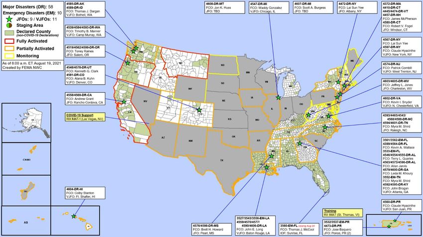
Disaster Declaration Activity             Event Monitoring
• None                                    • None

                                                            Federal Emergency Management Agency
                                                                                National Watch Center
Daily Operations Briefing - Thursday, August 19, 2021 8:30 a.m. ET - GovDelivery
Atlantic Overview
   TROPICAL OUTLOOK
Daily Operations Briefing - Thursday, August 19, 2021 8:30 a.m. ET - GovDelivery
Tropical Storm Henri
        SATELLITE LOOP

         5 AM AST
         • W at 9 mph
         • 995 mb
         • 70 mph
Daily Operations Briefing - Thursday, August 19, 2021 8:30 a.m. ET - GovDelivery
Tropical Storm Henri
       FORECAST TRACK

         5 AM AST
         • W at 9 mph
         • 995 mb
         • 70 mph
Daily Operations Briefing - Thursday, August 19, 2021 8:30 a.m. ET - GovDelivery
Tropical Storm Henri
MOST LIKELY ARRIVAL OF TS WINDS
                TS Wind Probabilities
                Eastport, ME        24%
                Boston, MA          28%
                Nantucket, MA       62%
                Providence, RI      46%
                Montauk Point, NY   46%
                Atlantic City, NJ   11%
                Ocean City, MD      18%
Daily Operations Briefing - Thursday, August 19, 2021 8:30 a.m. ET - GovDelivery
East Pacific Overview
      TROPICAL OUTLOOK
Daily Operations Briefing - Thursday, August 19, 2021 8:30 a.m. ET - GovDelivery
Hurricane Linda
  FORECAST TRACK

    11 PM HST
     • WNW at 17 mph
     • 983 mb
     • 85 mph
Daily Operations Briefing - Thursday, August 19, 2021 8:30 a.m. ET - GovDelivery
Remnants of Fred– Eastern US
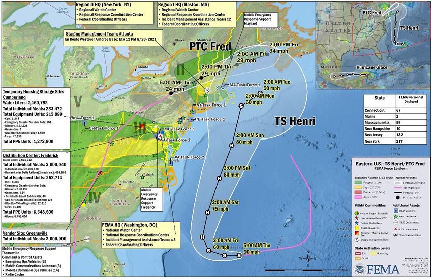
Situation: Response efforts to Tropical Cyclone Fred, which produced widespread flooding & isolated tornadoes in North Carolina, continue

Impacts: (Region IV Status Update 8 as of 9:29 p.m. ET)                                                                             FEMA Response
▪ NC: 4 (+1) shelters open / 61 (-17)                                                                                               ▪ Region IV RWC at Monitoring; RRCC rostered
  occupants                                                                                                                           o IMAT-1/IMAT-2 Available
  o NCNG activating to support search and                                                                                           ▪ FEMA HQ
     rescue operations; Swift water rescue                                                                                            o NWC coordinating with Regions, NHC, and
     continues                                                                                                                          National Water Center
  o Duke Energy reports damage to                                                                                                     o NRCC at Level III (COVID-19)
     electric infrastructure in western NC;                                                                                           o National IMAT Blue to support Region IV if
     assessments ongoing                                                                                                                needed
  o Numerous road closures in 3 counties                                                                                              o DEC: MERS assets identified/deployable; Mobile
     (Transylvania, Haywood, and Swain)                                                                                                 IOF ready to support IMAT deployment
     due to flooding, mudslides, landslides,                                                                                          o Logistics: Pre-positioned 1.4M meals and 1.1M
     and rockslides                                                                                                                     water at Craig Field
  o Minimal power outages less than 1%                                                                                                o US&R: IST rostered on 2hr PTDO
                                                                                                                                      o FOD: FCOs identified for each state in RIV
State/Local Response                                                                                                                  o Emergency Declaration FEMA-3562-EM-FL
▪ NC EOC at Partial Activation (COVID-19)                                                                                               Approved
▪ Governor declared a State of Emergency
   for 8 counties

                                                                                                                                            National Watch Center
Tropical Storm Henri– Preparations
Situation: As of 5:00 a.m. ET, the storm was located 525 miles SE of Cape Hatteras, NC.
Forecast to turn northwest on Friday. Swells generated by Henri expected to increase
across much of the east coast of the U.S. and Atlantic Canada later this week and this
weekend. These swells could cause life-threatening surf and rip current conditions.

Warnings/Watches
▪ No coastal watches or warnings in effect

State / Local Preparations:
▪ NYC EOC at Full Activation (COVID-19)
▪ All states and tribes monitoring; no activation changes at this time
▪ No requests for Federal assistance received and none anticipated

FEMA / Federal Preparations:
▪ FEMA Region I RRCC Rostered; RWC is Monitoring; prepared to activate additional
  resources, if necessary
  o IMAT-1: FMC
▪ FEMA Region II RRCC Rostered; RWC is Monitoring; prepared to activate additional
  resources, if necessary
  o IMAT-1: Deployed to USVI; returning 8/21
▪ FEMA HQ
  o NRCC at Level III (COVID); NWC is monitoring
▪ Logistics:
  o One SMT deploying to Region 1 (Westover, MA); expected to be in place tomorrow;
      an additional SMT on standby to support Region II, if needed
  o Prepared to pre-stage generators and other commodities (meals, water, etc.) as
      early as Saturday in both Regions
  o Transportation plan in development with both Regions

                                                                                          National Watch Center
National Weather Forecast
                            Thu                           Fri

                                                          Sat

                                  National Watch Center
Fire Weather Outlook

           Today       Tomorrow

                            National Watch Center
Wildfire Summary
                                                                       Structures (Homes / Other)
  Fire Name                     Acres       Percent                                                       Fatalities /
                  FMAG #                             Evacuations
 (County, ST)                  Burned      Contained                                                       Injuries
                                                                    Threatened Damaged Destroyed
                                                       M: 29,416                 H: 64      H: 665
                                                                 H:15,967
     Dixie                662,647                      (-348)                    (+14)      (+12)
              5400-FM-CA                   35% (+4)                                                          0/3
 (Plumas, CA)            (+35,896)
                                                       V: 0        O: 118        O: 32 (+2) O: 552 (-3)
                                                                   H: 7,000
                                                        M: 5,524                 H: 1       H:11
  Monument                    128,613                              (+2,000)
                5412-FM-CA                    10%                                                            0/2
  (Trinity, CA)               (+9,249)                             O: 3,100                 O: 21
                                                        V: 0                     O: 0
                                                                    (+850)                  (+20)
                                                       M: 42,048
     Caldor                                                      H:5,887         H: 0       H: 0
                          62,586                       (+25,198)
  (El Dorado, 5413-FM-CA                      0%                                                             0/2
                         (+39,667)
      CA)                                              V: 0        O: 10         O: 0       O: 0
                                                                   H: 293
                                                       M: 0                      H: 0       H: 1
*Fox Complex                    7,362                              (-401)
             5409-FM-OR                    35% (+5)                                                          0/0
 (Lake, OR)                    (+133)                              O: 576
                                                        V: 0                     O: 0       O: 3
                                                                   (+331)
* FoxComplex includes Patton Meadow & Willow Valley fires
(Evacuations: M = Mandatory / V = Voluntary; Structures: H = Homes and Mixed Commercial/Residential / O = Non-residential Commercial/Other Minor Structures)

                                                                                                                                                     National Watch Center
Wildfire Summary
                                                                      Structures (Homes / Other)
   Fire Name                    Acres      Percent                                                     Fatalities
                 FMAG #                             Evacuations
  (County, ST)                 Burned     Contained                                                    / Injuries
                                                                   Threatened Damaged Destroyed

    Bedrock                                     M: 300             H: 200       H: 0       H: 3
  (Nez Perce, 5407-FM-ID 11,167 (-38) 96% (+13)                                                          0/0
      ID)                                       V: 0               O: 50        O: 0       O: 19
   Parleys                                                         H: 0
                                                      M: 10,000                 H: 0       H: 0
   Canyon                                                          (-2,200)
               5408-FM-UT       541       80% (+40)                                                    0 / 1 (+1)
(Salt Lake and
                                                      V: 0         O: 0         O: 0       O: 0
 Summit, UT)
  Muckamuck                                            M: 232** H: 54 (-334) H: 0          H: 0
                               11,774
  (Okanogan, 5410-FM-WA                       5%                                                         0/1
                               (+907)
     WA)                                               V: 0        O: 0         O: 0       O: 0

      Ford                                             M: 811      H: 856       H: 0       H: 18
   Corkscrew 5411-FM-WA        14,000     14% (+14)                                                      0/0
 (Stevens, WA)                                         V: 0        O: 135       O: 0       O: 35

  Twentyfive                                           M: 0 (-534) H: 772       H: 0       H: 1
                          8,000
     Mile     5414-FM-WA                      0%                                                         0/0
                         (+4,000)                                                          O: 10
 (Chelan, WA)                                          V: 0        O: 10        O: 0
                                                                                           (+10)

** Includes 50 Emergency responders evacuated
(Evacuations: M = Mandatory / V = Voluntary; Structures: H = Homes and Mixed Commercial/Residential / O = Non-residential Commercial/Other Minor Structures)

                                                                                                                                                     National Watch Center
Joint Preliminary Damage Assessments
          State /                                 IA     Number of Counties
Region                       Incidents                                               Start – End
         Location                                 PA   Requested     Complete
                    Severe Storms and Flooding    IA       0            0               N/A
                             Jul 29-30            PA       2            0             8/23-TBD
           NH
                    Severe Storms and Flooding    IA       0            0               N/A
                             Jul 17-19            PA       3            1            8/4 – TBD
  I
                    Severe Storms and Flooding    IA       0            0               N/A
           VT
                               Jul 29             PA       2            0            8/4 – TBD
                    Severe Storms and Flooding    IA       0            0               N/A
           MA
                             Jul 16-21            PA       5            0            8/10 – TBD
                                                  IA       6             4           8/11 – TBD
           CA             August Wildfires
                                                  PA       6             1           8/11 – TBD
  IX
                    Northern Monsoonal Flooding   IA       0             0               N/A
           AZ
                             Jul 22-24            PA       3             0           8/16 – TBD

                                                                   National Watch Center
Declaration Requests in Process – 3
State / Tribe / Territory – Incident Description                                         Type   IA   PA     HM          Requested
Fort Peck Assiniboine & Sioux Tribes – Severe Storm, Straight-line Winds, and Flooding   DR     X             X             8/3
ND – Severe Storms, Straight-line Winds, and Flooding                                    DR          X        X             8/9
MO – Severe Storms, Straight-line Winds, and Flooding                                    DR          X        X             8/13

                                                                                                          National Watch Center
FEMA Common Operating Picture
                  FEMA HQ                                                                                                                                                             N-IMATs
      NWC                           NRCC                                                                                                                                       3 Teams Available
    Monitoring                     Level III
                                                                                                                                                                                Red
       FEMA REGIONS                                                                                                                                                            White       Training
    Watch                          RRCC                                                                                                                                         Blue
 Monitoring                 I      Rostered
 Monitoring                II      Rostered                                                                                                                                    Gold
 Monitoring               III      Rostered
 Monitoring               IV       Rostered                                                                                                                                           R-IMATs
              Alt Loc
Monitoring
             Nightshift    V        Level III                                                                                                                                 ≥ 7 Teams Available
 Monitoring               VI        Level III
                                                                                                                                                                                  I             2
Alt. Location             VII      Rostered
 Monitoring               VIII     Rostered                                                                                                                                      II         USVI
 Monitoring               IX       Rostered                                                                                                                                      III
 Monitoring                X       Rostered
                          Notes:
                                                                                                                                                                                IV-1
 NRCC:                                                                                                                                                                          IV-2
 Day shift, M-F             PR: Earthquakes and TC
 COVID-19                   Grace                                                                                                                                                V
 RRCCs:                     TX: Severe Weather                                                                                                                                  VI-1
 COVID-19 Response
                            LA: Tropical & Severe                                                                                                                               VI-2
 RV RWC: Dayshift,          Weather and Flooding
 Monitoring/ Night shift                                                                                                                                                        VII             1
 Remote Ops                 UT: Flooding
                                                                                                                                                                                VIII            3
 RVII RWC:                  MT, CO, AZ, CA, ID, WA,
 COVID-19 Protocols         & OR: Wildfires                                                                                                                                     IX-1         NV
                                                                                                                                                                                IX-2
                                                                                                                                                                                 X
                                                                                                                                                                                FMC         PMC
                                                                                                                                                                                NMC       Deployed

                                 US&R                MERS        FCOs            IM                                          IM CADRE AVAILABILITY SUMMARY
Team Status
                                 >66%                >66%       =3 Type I     WORKFORCE                                       Cadres with 25% or Less Availability
    Assigned:                      28                 36           54          14,191 (+33)
  Unavailable                      3                   0           1           3,461 (+19)      Civil Rights: 23% (26/111); Field Leadership: 18% (26/146); Hazard Mitigation: 25% (318/1,285);
    Deployed:                      0                 0 (-2)   43 (22 FCOR)      5,729 (-8)                       Public Assistance: 21% (605/2,842); Planning: 19% (85/458)
    Available:                     25               36 (+2)         10       35%/ 5,001 (+22)
Helping people before, during, and after disasters.

                   Scan to subscribe to this briefing.
You can also read