Focus On The Impacts Water Is What Kills Hurricane Preparedness 2021 - Erik Heden National Weather Service Morehead City, NC
←
→
Page content transcription
If your browser does not render page correctly, please read the page content below
Focus On The Impacts
     Water Is What Kills

   Hurricane Preparedness
            2021

               Erik Heden
National Weather Service Morehead City, NC
Our Local Office
   Eastern part of North
         Carolina

 Includes: Land areas, inland
 rivers, sounds, and adjacent
            ocean

   Other parts of the state
covered by other local offices
  (Raleigh, Wilmington, etc)
Work Hours

 24 hours a day, 7 days a week, plus any overtime for severe weather…we
                                never close!
                    Two to three forecasters per shift.
                 Shifts per day: midnight, day and evening.
Management team: 8 am to 5 pm Mon.-Fri. (they work shifts sometimes too!)
                         In total 22 to 25 people
Our Website
                                 weather.gov/moreheadcity

Weather information from past
 events, current weather, and
           forecast

   Explore the website and
bookmark or save what you like

  Go in depth as much as you
             need
Social Media
Search NWS Morehead City

             Hurricane Florence Lead
                       Up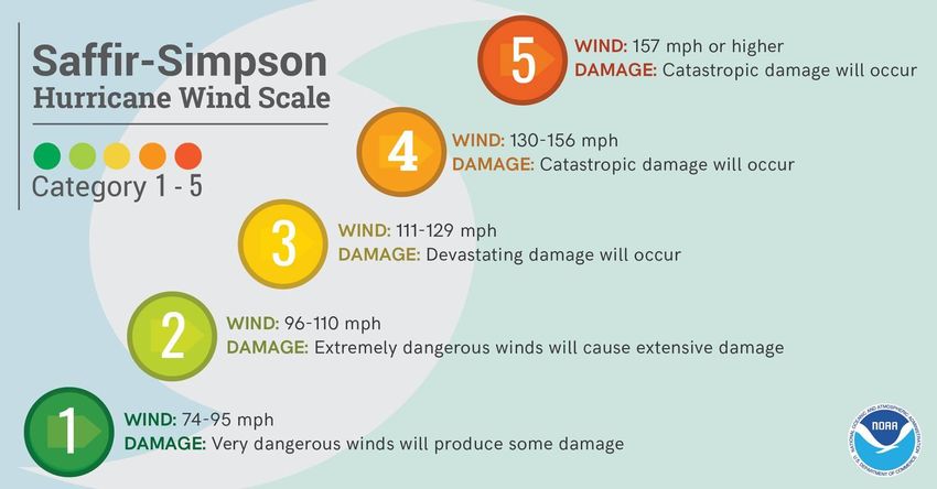
The Time To Prepare Is NOW
                                                               Peak of the
                                                               season is
                               Irene Hermine
Beryl Andrea Arthur
Alberto
                                               Matthew Sandy   around
                               Dorian
 Arthur
                      Isaias            Florence               September
                                                               10th

                                                               Tropical
                                                               systems can
                                                               occur from
                                                               May through
                                                               November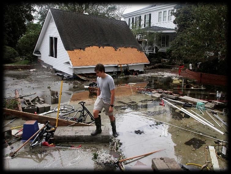
Our Website
weather.gov/moreheadcity/hurricaneprep

                        Modeled after hurricane
                        awareness week

                        Graphics and information
                        on how to prepare

                        Graphics and information
                        on ALL impacts from a
                        tropical cyclone
Weather Briefings
 weather.gov/moreheadcity
Spaghetti Models vs. NHC Forecasts

                    vs.

About 175 years of experience
         combined!
2019 Forecast Successes & Challenges
     How Far Have We Come Since Floyd?

                                         Difference in
                                         average 3-
                                         day track
                                         forecasts for
        2019
                                         Floyd (1999)
               1999                      and Dorian
                                         (2019)
Where were the nation’s most
powerful hurricanes three days before
landfall?
Labor Day
40 mph Andrew
50 mph
Camille
65 mphHurricane Preparedness weather.gov/moreheadcity/hurricaneprep Make Your Plan Today! Is Your Hurricane Kit Ready?
National Hurricane Center
                            Hurricanes.gov

Tropical Weather Outlook

 •   Issued 4 times a day

 •   8 and 2 AM/PM EDT

 •   Tropical cyclone
     formation potential for
     next 5 days
National Hurricane Center
Tropical Cyclone Track Forecast Cone
Watches/Warnings
Initial Wind Field
• Cone represents probable path of
the CENTER of the storm
• The cone does NOT show impacts
• Impacts can occur HUNDREDS of
miles from the center of the storm
• The center of the storm passes
within the cone roughly of the timeNational Hurricane Center
Hurricanes.gov
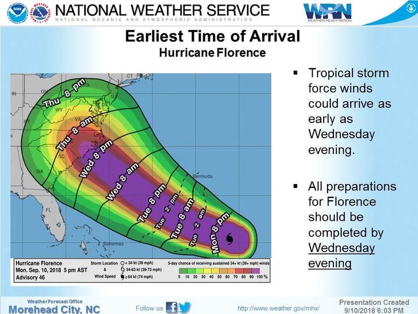
Earliest Reasonable Arrival Time
Tropical Storm Force Winds
• Reasonable worse case scenario
• Identifies a window when
preparations should be made by
• While times are given, especially
farther out, focus in more general
terms
• For example instead of Wednesday
8 PM or Thursday 8 AM
Sometime late Wednesday or early ThursdayNational Hurricane Center
Hurricanes.gov
Most Likely Arrival Time
Tropical Storm Force Winds
• Most likely scenario
• Identifies a window when we
expect tropical storm force winds
to arrive
• While times are given, especially
farther out, focus in more general
terms
• For example instead of Monday 8
AM
Sometime Monday MorningSaffir/Simpson Hurricane Scale
Used to categorize hurricane strength and to give an
estimate of potential property damageIt’s About the Impacts
Since 2010 in the U.S.,
Category 1 hurricanes*
175 direct deaths
$105 billion
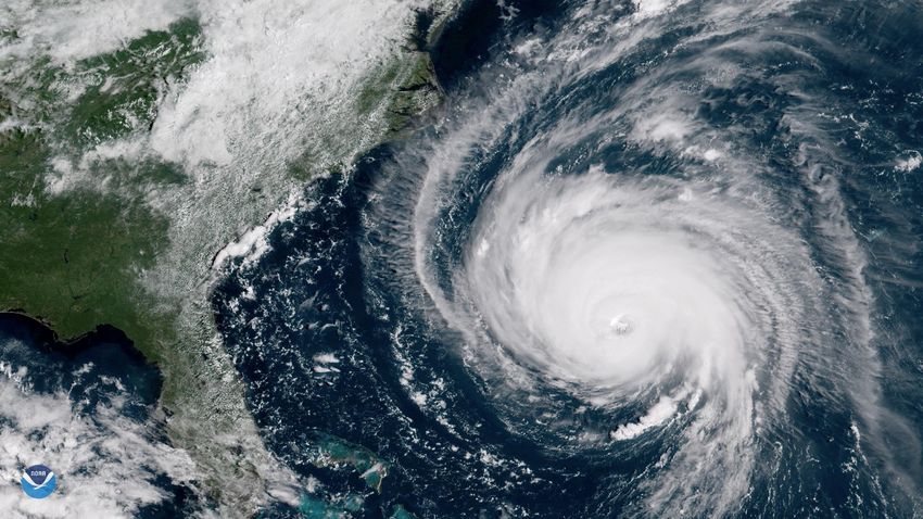
*Irene, Isaac, Sandy, Hermine, Matthew, Nate, Florence, Barry, DorianTropical Cyclones Produce
More Than Just Wind
Rainfall Flooding
Storm Surge
Rip Currents
Wind
TornadoesLesson 7. Water is What KILLS!!!
Rain Water
27%
accounts
for about
90% of
Surf 6%
the direct
Offshore 6%
Wind 8%
deaths
Tornado 3%
Other 1%
Rappaport 2014Water is What KILLS!!!
2016-18 Fatalities*
Other
Water Related
83% Water Related
Most Inland Flooding – Only 4% Storm Surge Related
*excludes Maria due to uncertainty related to causes of direct deathsWater is What KILLS!!!
• During the past three seasons, 2016-18 U.S. Tropical
Cyclone Water Related
more than half the U.S. Fatalities
tropical cyclone water-related
fatalities were vehicle related!Hurricane Florence
5-day Rainfall Forecast Observed Rainfall
Excellent Forecasts – Yet 16 out of 17 flood
related fatalities were in vehicles!Near Hookerton (Matthew)
Products We Issue
Storm Surge Florence/Dorian
                            8 to 11 feet storm surge
                            inundation in New Bern

                            Over 1,800 water rescues
                            in New Bern alone
New Bern

                            4 to 7 feet of surge from
                            Dorian on Ocracoke and
                            Hatteras Island

Ocracoke
Storm Surge Forecasting 5 am 11th 5 pm 11th
Storm Surge Forecasting
Experimental Peak Storm Surge
             Forecasting Graphic
• Visual representation of peak
  storm surge forecast values
  Public Advisory
• Primarily for media and social
  media applications where point
  probabilities and/or high-
  resolution inundation mapping
  not easily displayed
• Experimental for 2021 – NHC
  interested in comments and
  feedback                              35
Second Deadliest 2019 Atlantic Basin Storm
Lorenzo – 19 Direct Fatalities – All Water Related
Hurricane Lorenzo • Powerful Major Hurricane
for several days.
• North most CAT 5 on
record in Atlantic.
• 8 rip current deaths in the
8 rip current United States from Florida
fatalities in the to Rhode Island
United States • 4 in North Carolina alone
• Dangerous rip currents
can occur well ahead of
approaching stormsRip Current Messaging
Beach Safety
                                     •Choose a beach with a lifeguard on duty, and talk
                                     with them before swimming.

                                     •Pay attention to signs and flags to let you know
                                     where there might be danger.

                                     •Make sure everyone, especially children, has adult
                                     supervision at all times when in the water, even if
                                     they know how to swim.

                                     •Don’t become a victim while trying to help
                                     someone else!
If you’re caught in a rip current…
Float, Wave, and Yell                •Get help from a lifeguard. If a lifeguard is not
                                     present, call 9-1-1, then try to direct the victim to
         OR                          swim following the shoreline to escape. If possible,
   Swim Parallel                     throw something that floats toward the swimmer.
                                     Never enter the water without a flotation device.
Rip Current Messaging
Wind Threat
              • Disruption to power
                and communication
                network

              • Blocked evacuation or
                return routes due to
                fallen trees, power
                lines

              • Fallen tree danger
Arthur 2014
CAT 2
Similar Landfall
Faster Moving
Smaller StormIrene 2011
CAT 1
Similar Landfall
Slower Moving
Large StormTornado Threat
• Isolated areas of
enhanced damage
• Often occur with
smaller windows to
react to warnings
• Can occur well ahead
of the actual landfall,
Hurricane Dorian or well away from the
EF2 Tornado Estimated center (first outer
Winds 115 MPH bands)
Emerald Isle, NCFlorence
Tornadoes
Landfall of FlorenceQuestions/Comments erik.heden@noaa.gov
You can also read