October 2020 - Amazon AWS
←
→
Page content transcription
If your browser does not render page correctly, please read the page content below
October 2020

Current Situation and Outlook
A La Niña event has developed in the tropical Pacific in August-September 2020,
exceeding both oceanic and atmospheric thresholds. The latest forecasts from the
WMO Global Producing Centers of Long-Range Forecasts indicate a high likelihood
(90%) of tropical Pacific sea surface temperatures remaining at La Niña levels until
the end of 2020, and a moderate likelihood (55%) for them to persist through the first
quarter of 2021. Most models indicate that the 2020/2021 La Niña is likely to be a
moderate to strong event. National Meteorological and Hydrological Services will
closely monitor changes in the state of El Niño/Southern Oscillation (ENSO) over the
coming months and provide updated outlooks.

Following more than a year of ENSO neutral conditions (i.e., neither El Niño nor La Niña were
occurring), the east-central tropical Pacific sea surface temperatures cooled to La Niña levels
during August-September 2020, the exact timing depending on the specific thresholds applied.
Sub-surface water temperatures in the eastern Pacific also remained moderately below average.
The atmosphere responded to these changes with enhanced trade winds and stronger-than-
average upper level westerly winds, while cloudiness and rainfall have been below average in the
central and west-central tropical Pacific, and above average around the Maritime Continent. The
Southern Oscillation Index (represented by standardized Tahiti minus Darwin sea-level pressure
difference) has also been at La Niña levels during the last two months. These ocean patterns and
corresponding atmospheric changes are typical of a mature La Niña, while the below-average
sub-surface sea temperatures indicate a high likelihood of La Niña conditions persisting for
several months. Past observations show that the ENSO conditions observed during October
typically persist into the beginning of the following calendar year, with most events peaking
between October and the following January.

These recent conditions are the starting point for climate models from the WMO Global Producing
Centers of Long-Range Forecasts to produce global-scale forecasts for the coming months. More
than 95% of models predict sea surface temperatures to remain at La Niña levels until at least
the end of 2020. Based on the model predictions and expert assessment, the likelihood for La
Niña conditions to continue through the November-January 2020/2021 season is estimated to be
about 90%. The likelihood of ENSO-neutral is estimated to be about 10% and for El Niño it is
near-zero. However, it may be noted that the probabilities for La Niña during November-January
vary somewhat across the different forecasting centers, ranging from approximately 75% to
close to 100%. For the February-April 2021 season, the likelihood for La Niña conditions drops to
about 55%, while the likelihood for ENSO-neutral is about 40% and for El Niño it is about 5%.
The sea surface temperatures in the east-central tropical Pacific are likely to be in the range of
0.9 to 1.9 degrees Celsius below average during the November-January season, and 0.0 to 1.2
degrees Celsius below average during the February-April season. The most likely time for a
return to ENSO-neutral conditions is between March and May of 2021. At both forecast lead
times, there is a high likelihood for continuation of La Niña, and El Niño development is
considered to be extremely unlikely.

It is important to note that El Niño and La Niña are not the only factors that drive global and
regional climate patterns, and further that the magnitudes of ENSO indicators do not directly
correspond to the magnitudes of their effects. At the regional level, seasonal outlooks need to
assess the relative effects of both the ENSO state and other locally relevant climate drivers.
Regionally and locally applicable information is made available via regional and national seasonal
climate outlooks, such as those produced by WMO Regional Climate Centres (RCCs), Regional
Climate Outlook Forums (RCOFs) and National Meteorological and Hydrological Services (NMHSs).

In summary:
   •   The tropical Pacific transitioned to La Niña in August-September 2020, with thresholds
       exceeded for sea surface and sub-surface ocean temperatures, as well as for the
       atmospheric conditions.
• Model predictions and expert assessment indicate a 90% probability for La Niña during
November-January 2020/2021. For the February-April 2021 season, the probability for La
Niña decreases to about 55%, while that for ENSO-neutral rises to 40%.
• Sea surface temperatures in the east-central Pacific Ocean are most likely to be in the
range of 0.9 to 1.9 degrees Celsius below average during November-January 2020/2021,
and 0.0 to 1.2 degrees below average during February-April 2021.
The state of ENSO will continue to be carefully monitored by WMO Members and partners. More
detailed interpretations of the implications for regional climate variability will be carried out
routinely by the climate forecasting community over the coming months and will be made
available through the National Meteorological and Hydrological Services.
For web links of the National Meteorological Hydrological Services, please visit:
https://public.wmo.int/en/about-us/members
For information and web links to Regional Climate Outlook Forums (RCOFs) please visit:
https://public.wmo.int/en/our-mandate/climate/regional-climate-outlook-products
For the latest global seasonal forecast based on WMO Global Producing Centres of Long-Range
Forecasts, please visit:
https://ftp.cpc.ncep.noaa.gov/mingyue/GSCUWMO/Forecasts/GSCU_OND2020_Sep2020-fin.pdf
An archive of all WMO El Niño/La Niña Updates issued so far, including this one, is available at:
https://community.wmo.int/activity-areas/climate/wmo-el-ninola-nina-updatesAcknowledgements The WMO El Niño/La Niña Update is prepared through a collaborative effort between the WMO and the International Research Institute for Climate and Society (IRI), USA, and is based on contributions from experts worldwide, inter alia, of the following institutions: Australian Bureau of Meteorology (BoM), Centro Internacional para la Investigación del Fenómeno El Niño (CIIFEN), China Meteorological Administration (CMA), Climate Prediction Centre (CPC) and Pacific ENSO Applications Climate (PEAC) Services of the National Oceanic and Atmospheric Administration (NOAA) of the United States of America (USA), European Centre for Medium Range Weather Forecasts (ECMWF), Météo-France, India Meteorological Department (IMD), Indian Institute for Tropical Meteorology (IITM), Japan Meteorological Agency (JMA), Korea Meteorological Administration (KMA), Met Office of the United Kingdom, Meteorological Service Singapore (MSS), WMO Global Producing Centres of Long Range Forecasts (GPCs-LRF) including the Lead Centre for Long Range Forecast Multi-Model Ensemble (LC-LRFMME).
El Niño/La Niña Background
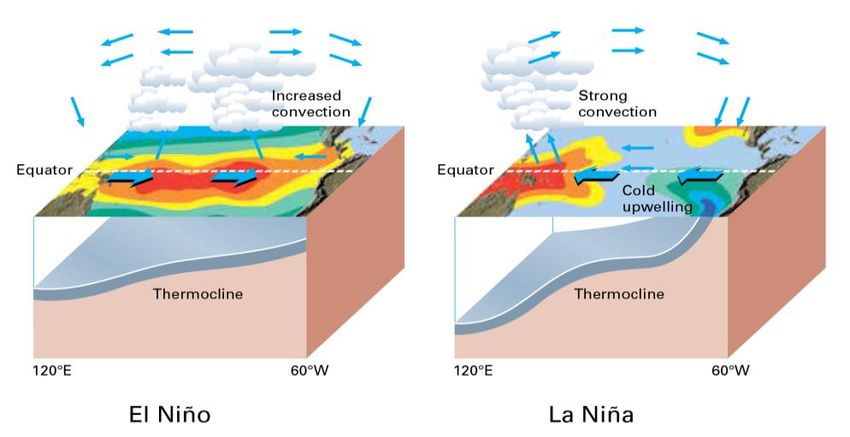
Typical circulation patterns during El Niño/La Niña (Source: WMO, 2003, “Climate into the 21 st Century”).
Climate Patterns in the Pacific
Research conducted over recent decades has shed considerable light on the important role played by interactions
between the atmosphere and ocean in the tropical belt of the Pacific Ocean in altering global weather and climate
patterns. During El Niño events, sea surface temperatures in the central and eastern tropical Pacific Ocean become
substantially warmer than normal. In contrast, during La Niña events, the sea surface temperatures in these regions
become colder than normal. These temperature changes are strongly linked to major climate fluctuations around the
globe and, once initiated, such events can last for 12 months or more. The strong El Niño event of 1997–1998 was
followed by a prolonged La Niña phase that extended from mid-1998 to early 2001. El Niño/La Niña events change the
likelihood of particular climate patterns around the globe, but the outcomes of each event are never exactly the same.
Furthermore, while there is generally a relationship between the global impacts of an El Niño/La Niña event and its
intensity, there is always potential for an event to generate serious impacts in some regions irrespective of its intensity.
Forecasting and Monitoring the El Niño/La Niña Phenomenon
The forecasting of Pacific Ocean developments is undertaken in a number of ways. Complex dynamical models project
the evolution of the tropical Pacific Ocean from its currently observed state. Statistical forecast models can also capture
some of the precursors of such developments. Expert analysis of the current situation adds further value, especially in
interpreting the implications of the evolving situation below the ocean surface. All forecast methods try to incorporate
the effects of ocean-atmosphere interactions within the climate system. The meteorological and oceanographic data
that allow El Niño and La Niña episodes to be monitored and forecast are drawn from national and international
observing systems. The exchange and processing of the data are carried out under programmes coordinated by the
WMO.
WMO El Niño/La Niña Update
The WMO El Niño/La Niña Update is prepared on a quasi-regular basis (approximately every three months) through a
collaborative effort between WMO and the International Research Institute for Climate and Society (IRI) as a
contribution to the United Nations Inter-Agency Task Force on Natural Disaster Reduction. It is based on contributions
from the leading centres around the world monitoring and predicting this phenomenon and expert consensus facilitated
by WMO and IRI.
For more information on the Update and related aspects, please visit:
https://public.wmo.int/en/our-mandate/climate/el-niñola-niña-updateYou can also read