Hurricane Florence - Preliminary Open File Report - South Carolina State Climatology Office - SC.gov
←
→
Page content transcription
If your browser does not render page correctly, please read the page content below
South Carolina State Climatology Office
Report Date: October 10, 2018
Email: GriffinM@dnr.sc.gov
Website: http://www.dnr.sc.gov/climate/sco/

Hurricane
Florence –
Preliminary Open
File Report

               PRELIMINARY
      Storm History and Impacts Report
          September 14 – 17, 2018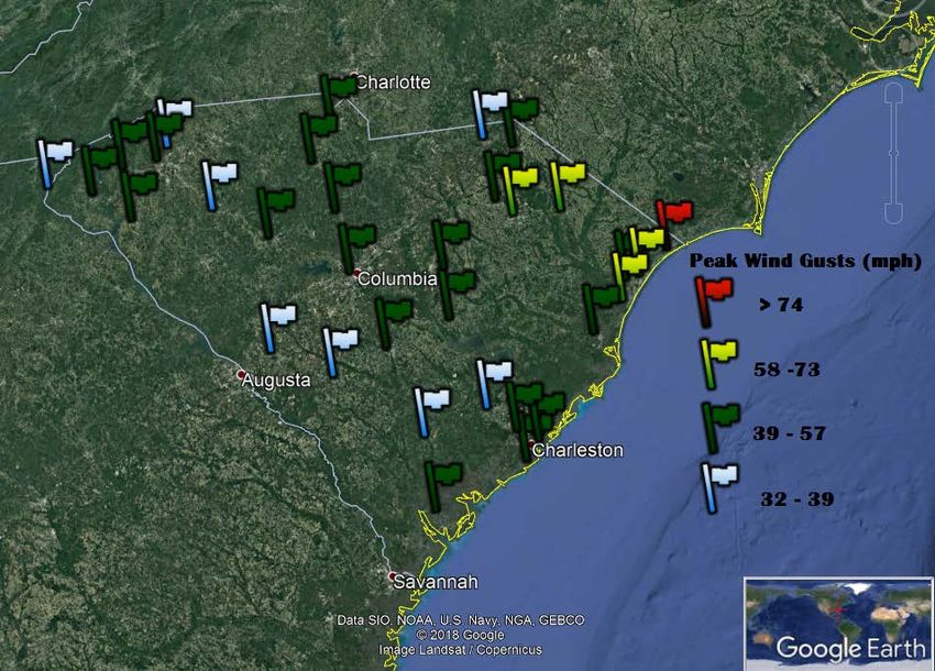
1
TABLE OF CONTENTS

  STORM OVERVIEW ................................... 2
  RAINFALL .................................................. 3
  RIVER STAGES ........................................... 4
  STORM SURGE AND TIDES ........................ 5
  TORNADOES ............................................. 6
  PEAK WIND GUSTS.................................... 7
  STORM FACTS ........................................... 8

                 THIS REPORT SERVES AS A PRELIMINARY DISSEMINATION OF INFORMATION. A
                 MORE DETAILED REPORT ON THE IMPACTS OF HURRICANE FLORENCE WILL BE
                 PROVIDED IN THE COMING WEEKS. FOR MORE DETAILED DATA, PLEASE CONTACT:
                                                                         MELISSA GRIFFIN
                                                          ASSISTANT STATE CLIMATOLOGIST
                                                            EMAIL: GRIFFINM@DNR.SC.GOV
                                                                  PHONE: 803-734-9091
2
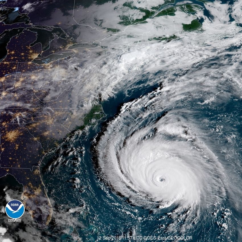
STORM OVERVIEW
Hurricane Florence
The 2018 Hurricane Season got off to a rather slow start. Florence was the sixth named storm and
formed from a tropical wave off the African Coast, near the Cape Verde Islands, on August 31. The
storm rapidly intensified from a Category 1 to a Category 4 Hurricane in a 24-hour period starting
on September 4.
The forecast models had trouble initially with
Florence’s track, with some models having the
storm turn out to sea, while others brought the
storm closer to the United States. The track of the
storm was unique, as past tropical cyclones that
originated in the same area turned to the north
and remained out to sea. The uncertainty was
based on the strength and placement of an upper-
level ridge and how it would essentially direct the
storm. Once the models had a better
understanding of the atmospheric steering
currents, it was obvious that the hurricane would make landfall somewhere along the Southeast
Coast.
As it moved across the Atlantic, the storm went through a process of weakening and was
downgraded to a tropical storm before re-
strengthening back to a Category 4 hurricane.
Before landfall, the storm encountered wind
shear, dry air and interacted with the continental
shelf along the Carolina coast, causing it to
weaken. Florence was a Category 1 Hurricane
when it made landfall near Wrightsville Beach,
North Carolina on the morning on September 14.
It proceeded to stall and remain nearly stationary
for an entire day before it began a slow turn to
the southwest, which is not a typical movement
for tropical cyclones, and traveled across South
Carolina at a speed of 2-3 mph. The storm
continued to weaken during the 15th and the
remnant circulation recurved and accelerated to
the north-northeast and out of the state on September 16th.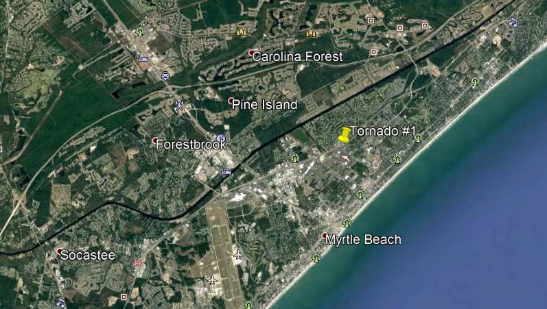
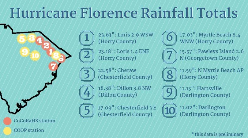
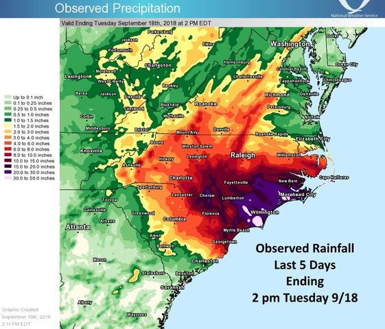
3
 RAINFALL

Excessive Rainfall Across The Carolinas
Before the landfall of Hurricane
Florence, the United States Drought
Monitor indicated areas of dry (D0)
and moderate drought conditions
(D1) in much of the Pee Dee region,
including Lancaster County and parts
of Chester, Chesterfield, Fairfield and
Kershaw counties. Streamflow
values across the same region were
below normal, and rivers such as the
Little Pee Dee at Galivants and the
Lynches at Bishopville were near
record low flows. A statewide
drought call scheduled for Thursday,
September 13th was canceled due to
preparations for Florence. The
magnitude of the event would have
been worse, had there been wet
antecedent conditions in the region.
The slow-moving system dropped more 30 inches of rain across portions of eastern North
Carolina, and over 20 inches of rain in Chesterfield and Horry counties.

The 4-day total of 23.63 inches, from the CoCoRaHS station at Loris 2.9 WSW, is listed as the
highest rainfall total in South Carolina caused by a tropical cyclone and its remnants, replacing
the previous total of 17.45 inches caused by Tropical Storm Beryl in 1994. This total is the second
highest 4-day total behind the 26.88 inches reported by the CoCoRaHS station at Mount Pleasant
6.4 NE during the October 2015 Flood (which was not considered coming from a tropical event
because of the interaction between the front and Hurricane Joaquin).
4
RIVER STAGES
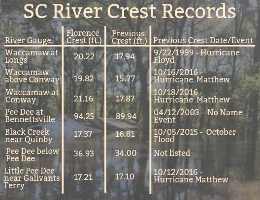
Record Crests On South Carolina Rivers
Unprecedented flooding
occurred in Florence’s
wake, as a portion of the
excessive amount of
rainfall measured in North
Carolina fell in the Yadkin-
Pee Dee River watershed.
This watershed drains to
the Atlantic Ocean by
passing through much of
South Carolina and
emptying out through
Winyah Bay. For weeks
after the initial landfall,
flooding plagued most of
the Pee Dee Region, with
the significant impacts along the Pee Dee, Little Pee Dee, Lumber, Lynches and Waccamaw rivers
and their tributaries.
Many of these river
gauges reached crest
values that fell within the
top five highest
measured crests at their
locations, while a
number of the rivers set
new record crest values.
The Pee Dee River at Pee
Dee reached a height of
31.83 ft. during the
flooding, which was 1.5
ft. lower than the historic
crest of 33.3 ft. during
1945. Gauges along
Waccamaw exceed
previous record crests by
3 or more feet during
this event.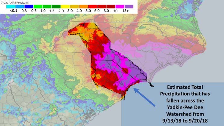
5
 STORM SURGE
 AND TIDES

Minor Beach Erosion Along The Coast
Hurricane Florence’s landfall and southwesterly tracks placed most of the South Carolina Coast on
the southerly side of the circulation. On this side of the storm, prevailing wind direction is
offshore, and because of the slow movement of the storm, the winds persisted for hours and
caused the water to retreat from the coastline. Tidal gauges along the coast measured low-tidal
water levels from September 13 to September 15. As the storm moved across the state, the wind
direction changed (onshore flow) and the water returned to normal levels before increasing as the
wind continued to push more water toward the coast. A storm surge of less than 2.5 ft. combined
with local tides, thus only minor erosion was reported in Horry and Georgetown counties.
6
 TORNADOES

Weak Tornadoes
Unlike other tropical cyclones to impact the state, Hurricane Florence only spawned two weak
tornadoes, both within Horry County.

Tornado #1 – 2 NNE Myrtle Beach (Horry County)
   • Rating: EF0
   • Date: 2018-09-16
   • Narrative: The tornado was
      shown live by a local television
      station as viewed from their sky
      camera. It caused minor damage
      to the tops of pine trees,
      breaking numerous limbs before
      it crossed highway 17 moving
      west. Additional minor tree
      damage occurred on the west
      side of Highway 17 before the
      fast-moving tornado lifted. Path
      width was 30 yards; the path
      length was 0.5 miles, maximum winds 70 mph, no injuries or fatalities.

Tornado #2 – 4 ESE Gorgetown (Horry County)
   • Rating: EF0
   • Date: 2018-09-16
   • Narrative: Tornado touched
      down six miles north-northwest
      of Longs, causing spotty damage
      to pine trees and damage to a
      roof.

There were also multiple reports of funnel clouds on September 16th across Horry County,
especially near the areas of Myrtle Beach and Loris.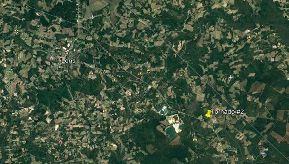
7
 PEAK WIND
 GUSTS

Limited Wind Damage

Hurricane Florence had a large diameter wind field, with hurricane force (sustained winds over 74
mph) extending 80 miles from the center of the storm, and tropical storm-force winds were felt
up to 200 miles away from the center.

Shortly before landfall on the morning of Friday, September 14, the National Weather Service
station at the Wilmington Airport in New Hanover County, North Carolina reported a wind gust of
105 mph. The highest observed wind gust associated with the storm in South Carolina was 77
mph measured at the Cherry Grove Beach Pier on September 14. Many stations across the
Lowcountry, Midlands, and Pee Dee region experienced peak wind gusts of 39 mph or
higher. Even after Florence was downgraded to a tropical depression on Sunday, strong
thunderstorm cells embedded within its rain bands caused high winds.

Despite the windy weather and saturated ground, utility companies reported less than 200,000
outages across the state, with most of those concentrated in Dillon, Horry, and Marion counties.
8
STORM FACTS

By The Numbers                          Aerial view of flooding along the
                                        Waccamaw River in Longs, SC

As of October 5, three weeks after
the initial landfall, many across
South Carolina are still dealing with
the impacts of Hurricane Florence.
Floodwaters are beginning to recede
across the Pee Dee Watershed and
now begins one of the hardest parts
of any Natural Disaster – Recovery.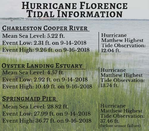
You can also read