Ohio UAS Center Strategic Plan 2019 - Ohio Department of ...
←
→
Page content transcription
If your browser does not render page correctly, please read the page content below
Ohio UAS Center Strategic Plan 2019

Why Ohio?
Ohio has a rich history of aviation going back to the days when the Wright Brothers
first pioneered flight in 1903. Today, Ohio remains a national leader in innovative flight
research through the aggressive promotion and utilization of unmanned aircraft to
improve business operations and quality of life.

Research and Development: No other state can match the resources available for
unmanned aircraft research in Ohio. In addition to the work FlyOhio is doing, Ohio is
also home to Wright-Patterson Air Force Base in Dayton and the prestigious Air Force
Research Laboratory, which focuses on four major directives: energy, propulsion,
material and sensor technologies. Some of the brightest minds in the world are
developing cutting edge technology that is bringing enabling technologies for UAS to
the forefront.
Test Infrastructure: Ohio has all the right resources to develop and test UAS
technologies. A broad range of state-of-the-art research and laboratory capabilities
allow for an unprecedented range of testing opportunities in dedicated environments.
Test ranges and related sensor environments are available to allow effective flight
tests supporting research and certification efforts.
Expertise and Workforce: With Wright-Patterson Air Force Base and the Air Force
Research Laboratory, NASA Glenn Research Center in Cleveland and NASA Plum
Brook near Sandusky, the state is at the top of the list for aviation specialists in the
nation. In addition, the State of Ohio already has approximately 1200 aerospace
companies making Ohio a great place to attract UAS companies to develop, test and
deploy their technology companies.

Unmanned aircraft systems (UAS) technology, known commonly as drone technology,
is fast transforming industries while creating new ones in virtually every sector of
our economy: industrial production, agriculture, commerce, transportation, retail
and logistics. Ohio understands that a state willing to invest in the research and
infrastructure needed to take part in this transformation will see those investments
rewarded with jobs, business investment and economic growth.
While Ohio today is second to none in state support for UAS research and
development, this technology is evolving rapidly, with other states eager to take the
lead. The enclosed strategic plan highlights the steps needed to facilitate our state’s
ongoing leadership position in UAS technology and development.

Ohio UAS Center and DriveOhio Partnership: Smart Mobility at Every Altitude
The Ohio UAS Center serves as the state’s one-stop shop for those developing, testing
and deploying UAS technology in Ohio. The team engages with public and private
partners, connecting government, industry and academia to advance the use and
commercialization of UAS technology. The Ohio UAS Center operates as part of the
Ohio Department of Transportation’s DriveOhio initiative.
Unmanned aircraft systems and autonomous/connected vehicles are parallel
technologies. Both of these technologies are advancing rapidly and disrupting
their respective industries by developing remote and automated operation for
transportation applications. By having these teams working collaboratively under
one umbrella on both air vehicle and ground vehicle advancements, we are able
to leverage the resources from both sectors to make smarter decisions and avoid
duplicative efforts.

        UAS Center Vision
        Ohio leads the nation in driving the advancement and integration of UAS
        technology for the benefit of the people of Ohio and the growth of the UAS
        industry in the state.

        UAS Center Mission
        To advance the use and commercialization of UAS technology in Ohio and the
        world, we will:
          •   Facilitate the safe deployment of unmanned aircraft into the national
        		    airspace system;
          •   Promote the benefits of UAS technology;
          •   Create partnerships within the public and private sectors; and
          •   Utilize UAS technology to improve government agency operations.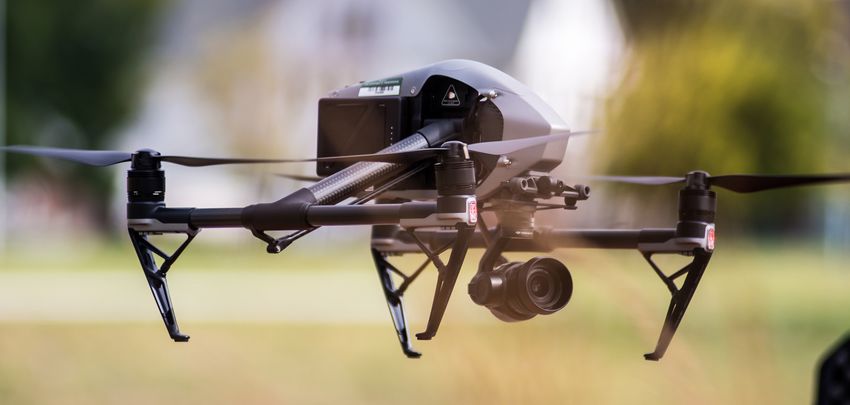
While UAS technology has advanced rapidly in the last few years, the widespread use
of drones is limited by the lack of a widespread low-altitude air traffic management
system to ensure drones can safely fly at altitudes below 2,000 feet without fear of
collision and do not pose a threat to people and property on the ground.
Because this system does not exist, the federal government generally restricts
anyone, without special permission -- including other government agencies – from
flying drones unless the operator can always see the aircraft. For most commercial
scenarios, such as package delivery and person transport, this limitation makes drone
usage impractical, if not impossible.
FlyOhio, an initiative of the Ohio UAS Center and DriveOhio, seeks to address this
gap by coordinating ongoing UAS research throughout Ohio, while identifying and
pursuing future research opportunities, to make Ohio airspace among the first in the
nation ready to fly beyond line of sight. The UAS Center will work with public, private
and research partners on the technology needed to allow numerous drones, operated
remotely, to fly safely over longer distances without fear they will collide with other
aircraft, ground-based objects or pose a threat to humans.
Further, by refining low-altitude air traffic control system, we can solve long-term
congestion issues, and bring the use of unmanned aircraft for freight, package and
personal transportation closer to reality.

Ohio is truly at the forefront of advancing
this technology. No other state is doing more
comprehensive research into the development
of an unmanned traffic management system.
And we are only just getting started.

Our Projects
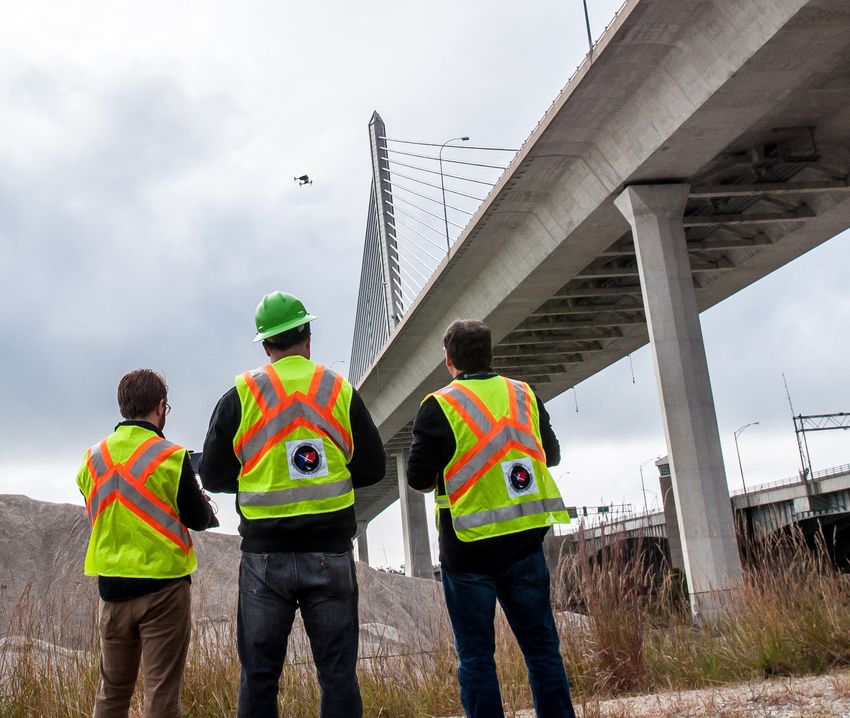
SkyVision
The Ohio UAS Center, the Air Force Research Laboratory (AFRL) in Dayton
and other partners have invested $5 million to develop and install SkyVision,
a ground-based detect-and-avoid radar system at the Springfield-Beckley
Municipal Airport in Springfield. The system uses three existing FAA active
radar systems to track unmanned aircraft allowing for drone flight beyond line
of sight.
A request from AFRL to the federal government to fly unmanned aircraft in the
national airspace system beyond line of sight is currently in process and flights
could begin in early 2019, pending federal approval. The Ohio UAS Center is
preparing to request similar permission in order to better facilitate the R&D,
testing, certification and commercialization of UAS systems in the state.
US 33 Traffic Monitoring
The UAS Center is partnering with The Ohio State University and others on
a three-year research project along the 33 Smart Mobility Corridor to develop
a different low-altitude air traffic management system using passive radar.
This research will include using communication devices on both air and
ground vehicles and will complement ongoing work to test autonomous and
connected vehicles along the 33 Smart Mobility Corridor, a 35-mile stretch of
highway between Dublin and East Liberty, Ohio.
The use of passive radar for managing the low-altitude airspace could be a
major key in finding a system that can be scaled up and deployed statewide.
Passive radar is much less expensive to install and therefore easier to scale.
The research will use the passive radar system, as well as sensors and
communication devices, to deploy drones for a specific use case:
monitoring ground vehicle traffic along the corridor.
Vertiport Development
As unmanned aircraft technology advances to support services like human
transport and package delivery, identifying locations that allow for vertical
aircraft takeoff and landing (known as vertiports) will become a vital
component to advancing the commercial use of drones in the state. For this
reason, the state issued a Request for Information (RFI) asking private-sector
companies to provide guidance that will help Ohio plan for deployment of
advanced unmanned aircraft technologies.
The request is specifically asking for information on the infrastructure needed
to identify vertiport locations and support vertical landing and takeoff activities.
FlyOhio is also looking for information relating to Electric Vertical Landing and
Takeoff (eVTOL), automated air taxis and taxi services, the use of personal
air vehicles, on-demand aviation, and any other related technologies
needed to implement and support this as an innovative alternative
transportation method.Workforce Development
Working with DriveOhio, the Ohio UAS Center is also actively engaging with
smart mobility workforce development stakeholders from government, industry,
education and local communities across the state. A statewide “Listening Tour” is
planned for 2019 to identify pilot programs around drone and UAS technologies.
These programs will deliver benefits across multiple industries including
technology and logistics for today’s workforce (e.g., up-skilling and certifications),
tomorrow’s workforce (e.g., capstone projects and work-based learning through
internships and apprenticeships), and the emerging workforce (e.g., K-12 problem-
based learning and Pre-K STEM).
Today’s Workforce Tomorrow’s Workforce Emerging Workforce
Employees / Incumbents Interns / Co-Ops Pre-Apprentices
Unemployed / Re-Entry Apprentices Career Technical Ed
Retirees / Disadvantaged Post-Secondary High School / K-8 / Pre-K
Agile Mindset / Problem-Based Learning
Workforce Mobility Student Mobility
Up-Skilling Educator Professional Development STEM Learning Kits
In-Demand Jobs Curriculum Development Career PathwaysOhio UAS Center Operations
Ohio is already systematically using unmanned aircraft to support a broad range of
business operations. Project surveying, infrastructure inspection, project monitoring,
environmental survey, resource survey, corrections facility surveillance, police and
firefighting support are among a few of the areas where Ohio is putting unmanned
aircraft to work in support of state and local government operations.
Statewide data collection operations include:
• Bridge Inspections
• Aerial Photography/GIS
• Exterior / Interior Inspections
• Construction Monitoring
• Traffic Monitoring
• Quick Clear Operations
• Emergency Management
• Communications / Promotional Videos
• Structures / Facilities Inspections
Flights Completed in 2018: 102
14 6 3 13 11 8 8 39
Communications Emergency Events Mapping Planning &
Management Facilities Engineering
Construction Environmental
Upcoming Flights: 39
24 7 1 4 3
Communications Environmental Planning &
Construction Engineering
Mapping
** As of 11/27/18Ohio UAS Center: Strategy and Actions Long-Term Strategy and Objectives To accomplish its mission and vision, the Ohio UAS Center will focus on the following: 1. FlyOhio – Develop and integrate next-generation UAS technology and infrastructure solutions, to grow Ohio’s position as a national UAS leader • Objective 1.1 - Deliver 33 Smart Mobility Corridor UTM research project phases on-time and on-budget • Objective 1.2 - Deliver SkyVision research and operations and obtain necessary approvals for flight from Federal Aviation Administration • Objective 1.3 - Planning and developing vertiports supporting the new vertical landing and takeoff technologies 2. Operations – Deliver and expand UAS operations and use case development services, to grow the Ohio UAS ecosystem and accelerate technology adoption • Objective 2.1 - Deliver 2018 UAS operations on-time and on-budget • Objective 2.2 - Develop 2019 UAS operations pipeline, targeting 60% expansion to include service contracts with other state agencies • Objective 2.3 - Expand UAS lifecycle support services, targeting 30% expansion 3. Workforce Development – Develop the future UAS workforce to expand relationships and grow Ohio’s UAS industry • Objective 3.1 - Execute marketing and communications plan, beginning with a listening tour • Objective 3.2 - Deploy UAS workforce development programs through DriveOhio • Objective 3.3 - Recruit UAS industry relocation / expansion, with JobsOhio
NEXT STEPS

                      Complete
    Commercialize                           Expand
                        UTM
      SkyVision
                      Research             Operations

       Convert      Explore with Private    Develop
                     Industry Vertiport
      Helipad to     Location Along 33
                                           Policy and
      Vertiport          Corridor          Procedures

    Develop State     Support              Hold a UAS
     Agency UAS     Colleges and           Airshow at
      Programs      Universities              TRC
OHIO UAS CENTER
3 MONTHS 6 MONTHS
FLYOHIO: FLYOHIO:
• Develop tools for others to operate SkyVision • AFRL obtain approvals from Federal Aviation
• Complete SkyVision scheduler software Administration for SkyVision for Beyond Visual
• Assess findings from vertiport RFI Line of Sight Operations
• Begin SkyVision flight operations
OPERATIONS:
• Develop SkyVision business plan
• Establish payment procedure for local • Announce private sector new partnership
governments • Process first data from 33 Smart Mobility
• Outreach to state agencies and local government Corridor UTM project
regarding drone operation opportunities
OPERATIONS:
WORKFORCE DEV:
• Development implementation common
• Engage with career-technical, community college operating platform
and university education partners • Proposal for a UAS airshow
• Complete development of 2-year general
services contract
WORKFORCE DEV:
• Initiate projects with career-technical,
community college and university partnersROADMAP
12 MONTHS 18 MONTHS +
FLYOHIO: FLYOHIO:
• Promote vertiport installations in SkyVision • Partner with NASA for NE Ohio drone operations
and the 33 Smart Mobility Corridor UTM • Complete identification of vertiport locations
research areas • SkyVision operating at least 75% to total
• Begin testing and demonstrations along the 33 capacity
Smart Mobility Corridor
OPERATIONS:
• Demonstrate the integration of 33 Smart Mobility
Corridor UTM air vehicles with connected ground • Complete UAS facilities improvements at
vehicles Springfield Beckley Airport
• Complete model to quantify cost savings of
OPERATIONS: utilizing drone technologies
• Finalize standard drone operations procedures
• Complete agreements with state agencies
WORKFORCE DEV:
• Identify pilot projects with K-12 STEM education
partners4170 Allium Court
Springfield, OH 45505
uas.ohio.govYou can also read