Peak Streamflow Determinations in Nevada: A Cooperative Program with the USGS and Nevada Department of Transportation

Page created by Gene Wagner
 
CONTINUE READING
Peak Streamflow Determinations in Nevada: A Cooperative Program with the USGS and Nevada Department of Transportation
Prepared in cooperation with Nevada Department of Transportation

Peak Streamflow Determinations in Nevada: A Cooperative
Program with the USGS and Nevada Department of
Transportation
Background                                   2 miles of Interstate 15 in southern         for planning by government agen-
                                             Nevada was heavily damaged by the            cies; designation of flood zones; and
     Floods are one of the most
                                             remnants of Hurricane Norbert com-           design of infrastructure including cul-
costly and frequent natural disasters
                                             bined with monsoonal rains (Sutko,           verts, bridges, and roadways. In order
in Nevada. For example, the 1997
                                             2015). Flooding in Nevada is highly          to provide accurate estimates of flood
New Year’s flood has been estimated
                                             variable in cause and the season of          frequencies, long-term data collection
to have caused more than $1 billion
                                             the year. Flooding can be caused by          of peak streamflows would be needed
in damage across northern Nevada
                                             snowmelt, rain on snow (fig. 1), and         because the accuracy of estimates
(Truckee River Flood Management
                                             flash flooding during thunderstorms.         improves with longer datasets.
Authority, 2017). In 2014, more than
                                             Peak streamflow estimates are critical

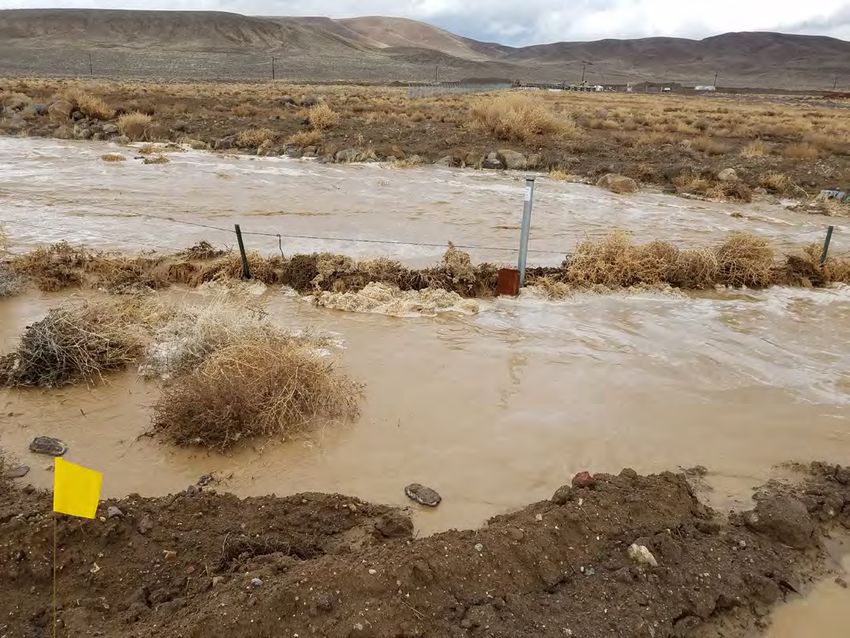
Figure 1. Example of flood event at crest-stage gage at station 10312075 Ramsey Canyon Wash at Hwy 50 at Silver Springs, NV, on
February 14, 2019.
U.S. Department of the Interior                                                                                     Fact Sheet 2021–3015
U.S. Geological Survey                                                                                                       March 2021
Peak Streamflow Determinations in Nevada: A Cooperative Program with the USGS and Nevada Department of Transportation
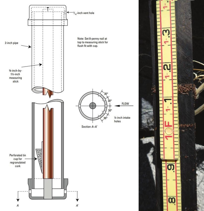
The Program                      for measurements to be                                    measurements of stream-                         streamflow for gage sites
                                 obtained at the site using                                flow are taken by using                         are entered in a publicly
      Since 1961, the United
                                 current meters or other                                   surveys of channel geom-                        available database called
States Geological Survey
                                 methods. Gages also are                                   etry, the water surface dur-                    the National Water Infor-
(USGS), in a cooperative
                                 visited during times of                                   ing the flood peak, and any                     mation System (NWIS),
program with the Nevada
                                 flooding or shortly there-                                structures (such as culverts                    which can be accessed at
Department of Transporta-
                                 after to obtain either direct                             or bridges) to model and                        http://nwis.waterdata.usgs.
tion (NDOT), has collected
                                 or indirect streamflow                                    estimate the peak stream-                       gov/usa/nwis/peak.
annual peak streamflow
                                 measurements. Indirect                                    flow. The peak annual
data at selected gage sites
across the state of Nevada
                                                120°                                       118°                                116°                        114°
(fig. 2). The purpose of
this project has been to         42°                                    OREGON                                                        IDAHO
characterize annual peak
streamflows at the selected
gage sites for use in flood
frequency analysis. The
USGS collects annual peak
                                                                                                                            #          17

streamflow data through
this project at 26 loca-
                                                                                                   #   22
                                                                                                                            #" Elko
                                                                                                                               18

                                                                                                                           #

                                                                                                                                                             UTAH
tions in Nevada. The peak                                                                                                       19
streamflow data are col-
lected through a network of
                                                                                                            #
                                                                                                           21      20

crest-stage gages (CSGs)         40°

maintained across the state                         #
                                                 Reno
                                                               25
by the USGS.
      A crest-stage gage
                                                  "
                                                   ##     24           16                           #  7

(fig. 3) is a device that
                                                ### #                                      #  6
records peak stage between
site visits. Crest-stage
                                                ###
gages used by the USGS in
Nevada typically consist of
a 2-inch pipe with vented
caps on the top and bot-
                                 38°
tom of the pipe; contained
within the pipe is a mea-
suring stick with granu-
lated cork on the bottom.
                                                        # #                  23        15

                                                     ##                                           CA NE
As the flow rises during a                                                    14
flood, the cork contained
                                                             13                                     LI VA
                                                                                                      FO DA

                                                  # "#
within the pipe floats on                                                                               RN
                                                                                                                                       ##
                                                                                                                                                                  ARIZONA
                                                                              26                                                                   1
                                                       12                                                  IA
the water surface. As the
flow recedes, the cork                                   #                    11
                                                                                                                                              Glendale
                                                                                                                                                      " 2

adheres to the stick and a                  Gardnerville #                   10                                           # Las Vegas " 3#
                                                                                                                           8
mark is left on the stick,
thereby recording the peak
stage of the flood (fig. 3).
                                 36°
                                                                                                                               ##      9       4

Lower subsequent peaks                      0                     50                 100               150 MILES

also can leave a mark on                    0           50             100         150 KILOMETERS
                                                                                                                                       #               5
the stick if enough cork
remains in the pipe.
      Crest-stage gages                Base from U.S. Geological Survey and U.S. Census Bureau data digital data, 2015.
are routinely visited                  Shaded-relief base from 3DEP 10-meter digital elevation model, 2016.
every 6 weeks to be                    Universal Transverse Mercator projection, Zone 11
                                       World Geodetic System datum of 1984
inspected, serviced, and
                               Figure 2. Crest-stage gage sites in the network (see “table 1” for the gage-site numbers).
3⁄16 - inch vent hole

                                                 Note: Set 8-penny nail at
       2-inch pipe                               top to measuring stick for
                                                 flush fit with cap.

       3⁄4-inch-by-
       11⁄2-inch
       measuring
       stick

                                                                          30°

                                                                                30°
                                                                                            Flow

                                                                                30°
                                                                                      1⁄4-inch intake
                                                                          30°
                                                                                      holes
                                                         Section A–A’

         Perforated tin
         cup for
         regranulated
         cork

               A                                  A’

Figure 3. Details of crest-stage gage (CSG) design from Sauer and Turnipseed (2010) and an example of marks left on a CSG stick
after multiple peak flows.

Summary                                                                        miles (mi2). The largest recorded peaks ranged from
                                                                               56 to 12,000 cubic feet per second (ft3/s); these flow events
     The annual peak streamflow collected, through this
                                                                               can be used to determine estimates of flood frequency and
cooperative program with the U.S. Geological Survey
                                                                               size. In an effort to minimize flood risk and damage, these
(USGS)    and the Nevada
    sac20-4246_fig 03     Department of Transportation
                                                                               estimates of flood frequency and size can be used to design
(NDOT), at these 26 sites represents 832 peak flow events
                                                                               structures to withstand flood damage, designate flood
(table 1; U.S. Geological Survey, 2020). The drainage
                                                                               zones, guide management decisions, and direct future
areas of these sites range in size from 0.62 to 1,542 square
                                                                               planning.
Table 1. Largest recorded peak streamflow through water year 2020 and associated drainage area at gage sites in Nevada in
cooperation with the Nevada Department of Transportation (NDOT).
[ID, identification; mi2, square mile; mm/dd/yyyy, month/day/year; ft3/s, cubic foot per second]

                                                                                                    Water year    Drainage area                                Magnitude
 Map ID           Station ID                                  Name                                                                          Date
                                                                                                   established)        (mi2)                                     (ft3/s)
      1           09415851            Muddy Wash near Moapa, NV                                       2012            7.8               09/26/2014               2,800
      2           09418990            Weiser Wash near Glendale, NV                                   1966           43                 09/08/2014              12,000
      3           09419570            Echo Wash at Northshore Rd near Echo Bay, NV                    1990          106                 08/15/1990               6,000
      4           09419680            Cottonwood Valley near Blue Diamond, NV                         1961           18.3               01/25/1969               1,100
      5           09423300            Piute Wash tributary at Searchlight, NV                         1967            3.4               08/13/1982                400
      6           10244360            Dixie Creek Valley Tributary near Eastgate, NV                  1961           11                   08/1961                1,480
      7           10249417            Smith Creek Valley Tributary near Austin, NV                    1968            0.62                07/1984                 130
      8           10251259            Amargosa River at Hwy 127 near California –                     1993        1,542                 09/22/2007                660
                                       Neavada state line
      9           10251980            Lovell Wash near Blue Diamond, NV                               1965           52.8               01/25/1969               4,150
    10            10309035            Indian Creek above mouth, near                                  1986           25.4               02/19/1986               2,100
                                        Gardnerville, NV
     11           10309075            Buckeye Creek at East Valley Road, near                         1992           73.8               07/14/1992               3,000
                                        Minden, NV
    12            10310410            Genoa Canyon Creek at Genoa, NV                                 1997            2.24              01/01/1997                150
    13            10310600            Voltaire Canyon near Carson City, NV                            1979            1                 01/02/1997                118
    14            10311450            Brunswick Canyon near New Empire, NV                            1966           12.7               01/08/2017                730
    15            10311725            Six Mile Canyon at Hwy 50 near Dayton, NV                       1986           17.29              01/09/2017                663
    16            10312075            Ramsey Canyon Wash at Hwy 50 at Silver                          2016           44.67              01/09/2017                669
                                        Springs, NV
    17            10317460            Gance Creek at Hwy 225 near Tuscarora, NV                       1980           20.2               04/30/2006                109
    18            10318850            East Adobe Creek near Elko, NV                                  1971            6                 07/27/1971                424
    19            10322980            Cole Creek near Palisade, NV                                    1962           11.4                 06/1983                1,090
    20            10326825            Mill Creek near Battle Mountain, NV                             2006        Indeterminate         04/15/2009                 56
    21            10326826            Mill Creek N. Channel near Battle Mountain,                     2011        Indeterminate         09/02/2013                 56
                                       NV
    22            10328000            Pole Creek near Golconda, NV                                    1961           10.7               08/05/1961               4,000
    23           103448600            Jumbo Wash near New Washoe City, NV                             1986            4.86              07/22/1986               1,230
    24            10350100            Long Valley Creek near Happy Valley, NV                         1956           82.6               02/19/1986               5,400
    25            10351850            Pyramid Lake Tributary near Nixon, NV                           1968            1.94              01/08/2017               1,220
    26           1030909087           Johnson Wash at Fremont Dr near Minden, NV                      1991           10.4               07/22/1994               1,400

                                                                                        U.S. Geological Survey, 2020, National Water Information System
- Kurtiss Schmidt                                                                         data, USGS Water Data for the Nation, accessed March 11, 2020, at
                                                                                          https://dx.doi.org/10.5066/F7P55KJN.
References Cited
Sauer, V.B., and Turnipseed, D.P., 2010, Stage measurement at gaging
  stations: U.S. Geological Survey Techniques and Methods 3–A7, 45                                        For more information
  p., https://pubs.usgs.gov/tm/tm3-a7/.
                                                                                                          U.S. Geological Survey
Sutko, T.E., 2015, Rainfall and flood report September 8, 2014: Clark                                     Nevada Water Science Center
  County Regional Flood Control District, Board of Directors Meeting,                                     2730 North Deer Run Road
  Las Vegas, Nev., October 2015, accessed February 5, 2020, at                                            Carson City, NV 89701
  https://gustfront.ccrfcd.org/pdf_arch1/Flood%20Event%20                                                 http://nevada.usgs.gov
  Reports/2014-09-08%20Rainfall%20and%20Flood%20Event%20
  Report.pdf

Truckee River Flood Management Authority, 2017, Nevada flood                                                              ISSN 2327-6916 (print)
                                                                                                                          ISSN 2327-6932 (online)
  awarness: Truckee River Flood Management Authority web page,                                                            https://doi.org/10.3133/fs20213015
  accessed January 30, 2020, at https://trfma.org/resources/nevada-
  flood-awareness/.
You can also read