Government of India Ministry of Earth Sciences - Developed by In association with - NCCR
←
→
Page content transcription
If your browser does not render page correctly, please read the page content below
Government of India
    Ministry of Earth Sciences

   Developed by

In association with

                                 1|Page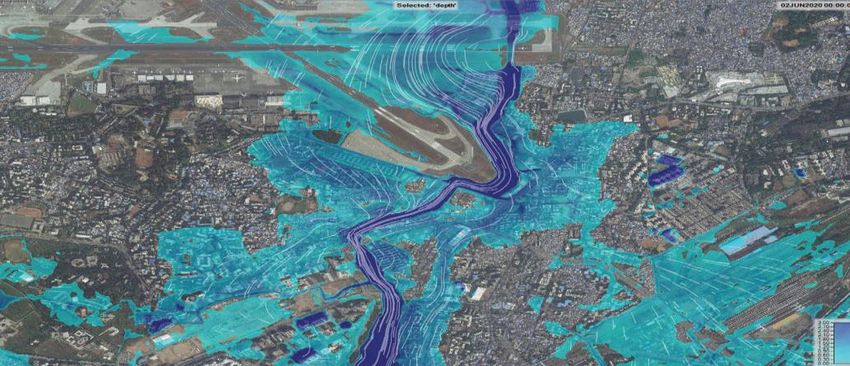
1.0 State of art flood warning system - An overview

As an excellent example of a G2G initiative in building a disaster resilient India, a state of art
flood warning system has been developed for Mumbai, by the Ministry of Earth Sciences (MoES),
Government of India in Collaboration with Disaster Management Department, Municipal
Corporation of Greater Mumbai (MCGM), Govt of Maharastra. This Integrated Flood Warning
system for Mumbai referred to as iFLOWS-MUMBAI, was launched through video conference
jointly by Chief Minister of Maharashtra, Shri Uddhav Thackeray and Union Earth Sciences
Minister Dr. Harsh Vardhan on 12th June 2020.

2.0 Genesis and development of the iFLOWS-Mumbai

        Mumbai, the capital of the state of Maharashtra, a megapolis and the financial capital of
India has been experiencing floods with increased periodicity and almost every monsoon,
Mumbai struggles to cope with the chaos caused by the rains. The suburban trains which serve
as the city's lifeline gets affected, low-lying areas get flooded, traffic jams and water logged
streets add to the woes of the Mumbaikars. The Mumbai flood during 26th July 2005, is
probably etched in the memory of every Mumbai citizen, when the city received a rainfall of
94cm, a 100 year high in a span of 24 hours paralyzing the city completely. Anticipating floods
before they occur, facilitates precautions to be taken so as to protect property and save lives.

       In a bid to aid in the mitigation activities of the flood prone city, Disaster Management
Department, of MCGM, Govt. of Maharashtra approached the MoES to develop iFLOWS-
Mumbai, as similar system was already developed by MoES and put into operation in Chennai.
MoES initiated the development of flood warning system in July 2019 through National Centre
for Coastal Research(NCCR), an attached office using the in-house expertise available within the
Ministry (India Meteorological Department (IMD), Nation Centre for Medium Range Weather
Forecasting (NCMRWF) and Indian Institute of Tropical Meteorology (IITM)), in close
coordination with Disaster Management Department of MCGM. iFLOWS-Mumbai is a state of
art webGIS based decision support system to enhance the resilience of Mumbai city by
providing early warning for flooding specially during high rainfall events and cyclones. NCCR has
put the system in pilot mode through Disaster Management Department of MCGM and
coordinated by IMD-Mumbai.

3.0 Architecture of iFLOWS-Mumbai

iFLOWS is a webGIS based decision support system built on a modular structure and comprises
following modules namely Data Assimilation module, Flood module, Inundation module,
Vulnerability module, Risk module and Dissemination module as shown in Fig.1.

                                                                                      2|Page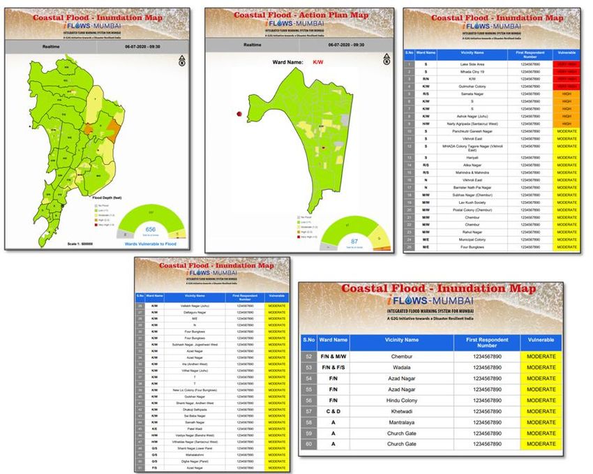
Fig 1: Architecture of iFLOWS-Mumbai
Fig 1: Launch of IFLOWS-Mumbai
Fig 1: Launch of IFLOWS-Mumbai
The Data Assimilation Module incorporates the following datasets namely;
Downscaled weather models for Mumbai from NCMRWF, IMD & IITM
Weather forecast from IMD
Rainfall data from a network of automatic rain gauges (120 stations) from IITM,
IMD and MCGM. (Fig.2)
Digital elevation model with a resolution of 20 cm from Disaster Management
Department of MCGM
Water level data across rivers from DMD, MCGM
Landuse, infrastructure and other thematic datasets were provided by Disaster
Management Department of MCGM.
Bathymetry data for rivers and lakes across Mumbai city, extensive field survey
conducted by NCCR, Disaster Management Department of MCGM and IMD,
Mumbai.
The Flood Module simulates the combined effects due to river flow, inundation in floodplains,
flooding in streets, collection through drainage networks, inundation due to storm surge in
coastal areas and breach discharges from reservoirs. For the study area an integrated hydraulic
and 2D hydrodynamic model is created which simulates the flow of runoff from precipitation
over the study area, the flow of water that breaches the river banks (river model), effects of
overflowing from drainages (1d hydraulic model) and the effect of the coastal boundary on
3|Page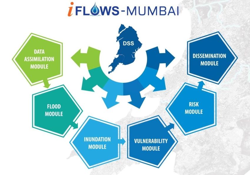
Fig.2. Meteorological forecast Models and Observation datasets in iFLOWS-Mumbai

inundation in the study area. The 2D hydrodynamic model also has the sea bathymetry
integrated with it and considers water levels of the sea at the coast as the offshore boundary
condition. The inundation model translates the model outputs to inundation maps and stored
in the Geodatabase. Spatial analysis are carried out in a GIS environment and vulnerability and
risk are calculated. Flood reports incorporating the water depths are generated at city and ward
level to enable the administration to take smart decisions to manage the situation based on a
scientific and holistic assessment of flooding risks. The Dissemination Module makes
information available to field officials through various communication channels, enabling them
to take prompt and informed field action.

4.0 iFLOWS-Mumbai-workflow

       The primary source for the system is the amount of rainfall, but with Mumbai being a
coastal city, the system also factors in tidal waves and storm tides for its flood assessments.
Based on inputs from weather models, Hydrologic models are used to transform rainfall into
runoff and provide inflow inputs into the river systems. Hydraulic models are used to solve
equations of fluid motion to replicate the movement of water to assess flooding in the study
area. The hydro dynamic models and storm surge model are used to calculate the tide and
storm surge impacts into the model domain.

                                Fig 3: Flood Inundation Modelling

                                                                                     4|Page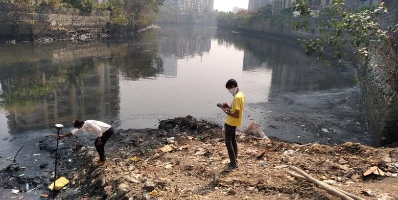
The system will use forecasted rainfall from the numerical weather models and Flood
inundation will be estimated for Mumbai three days in advance. The system will also work in
now cast mode using precipitation data available from the dense network of rain gauges and
radars established by Ministry. A web GIS based decision support system is build to calculate
the vulnerability and risk of elements exposed to flood. The infographics of the system is shown
as fig.4.
Fig.4 Infographics on the workflow in iFLOWS-Mumbai
Fig 1: Launch of IFLOWS-Mumbai
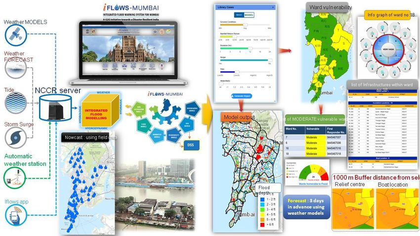
5.0 Utility of iFLOWS-Mumbai
Fig 1: Launch of IFLOWS-Mumbai
iFLOWS-Mumbai is a monitoring and flood warning system that will be able to relay
alerts of possible flood-prone areas between six to 72 hours in advance. The system can provide
all information regarding possible flood-prone areas, likely water depth, location-wise problem
areas across all 24 wards and calculate the vulnerability and risk of elements exposed to flood.
This data will be useful to the administration to plan evacuation from low lying areas atleast 12
hours in advance. iFLOWS-Mumbai will address the flood inundation due to rainfall, river bank
breach, storm surge, obstruction of flow due to roads, buildings, rail lines, high tides and sea
level rise. The system will help make the city become more resilient, by providing early warning
for flooding especially during high rainfall events and cyclones. The dashboard of iFLOWS-
Mumbai is shown as Fig.5.
5|Page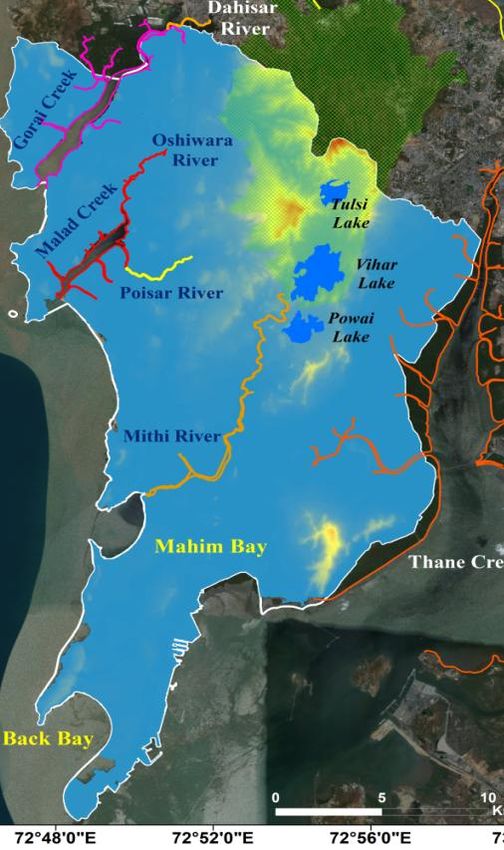
Fig 5: iFLOWS-Mumbai WebGIS dashboard
                               Fig 1: Launch of IFLOWS-Mumbai
Based on weather forecast models, flood models are run and water level reports are generated
                                Fig 1:
at ward level to help identify the     Launch
                                    most      of IFLOWS-Mumbai
                                          vulnerable  areas and dynamic charts help the decision
makers in their flood mitigation operation. All outputs including the model and vulnerability
reports are uploaded in the server and made available at realtime to IMD-Mumbai and DMD-
MCGM (Fig 6).

                      Fig. 6: iFLOWS-Mumbai Flood Reports at Ward level
                                  Fig 1: Launch of IFLOWS-Mumbai

                                                                                     6|Page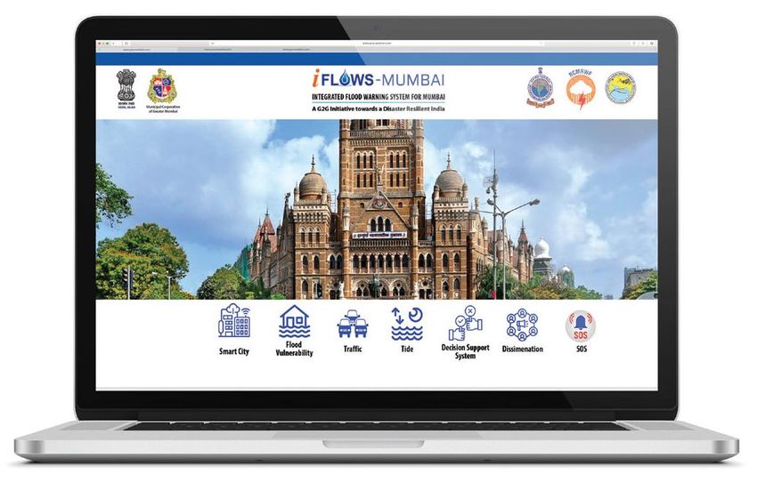
Apart from the Dashboard a “Flood Atlas” has been prepared depicting areas prone for flooding
using various flood scenarios to serve as a ready reckoner to help plan mitigation operation
well ahead of the monsoon season.

                               Fig. 7: iFLOWS-Mumbai Flood Atlas
                                  Fig 1: Launch of IFLOWS-Mumbai

IFLOWS-Mumbai is presently in testing phase (Monsoon 2020) and the operational system will be
handed over to DMD-MCGM and it will be maintained with support of IMD-Mumbai

                                                                                   7|Page
Topographic Survey

Bathymetric Survey

                      Extensive bathymetry
                     data collection across all
                     major river and lakes of
                     Mumbai (Feb 2020), by
                     NCCR, DMD-MCGM and
                           IMD-Mumbai

                               8|Page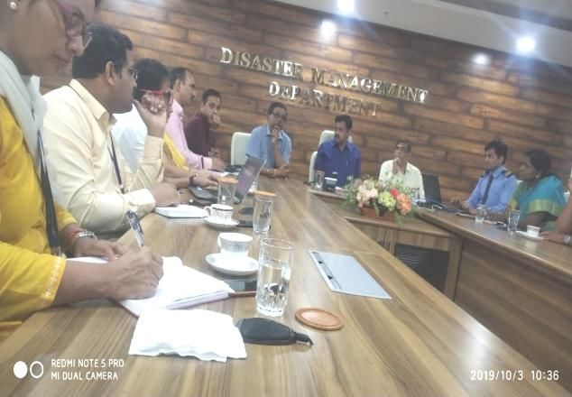
PERIODIC REVIEW MEETINGS

        VIDEOS

IFLOWS-MUMBAI-VIDEO

IFLOWS-MUMBAI-LAUNCH

                            9|Page
You can also read