Preliminary Airspace Review Of Dubbo, NSW - March 2018 - Civil Aviation ...
←
→
Page content transcription
If your browser does not render page correctly, please read the page content below
Preliminary Airspace Review
      Of Dubbo, NSW
        March 2018
Office of Airspace Regulation                                                          Page 2 of 12

DOCUMENT SPONSOR:                    OFFICE OF AIRSPACE REGULATION

TRIM REFERENCE:                      D17/397583

FILE REF:                            FO17/1078

                                               Document control:

              Version           Issue/Nature of Revision           Date
              0.1               Initial draft                           October 2017
              0.2               Contains peer feedback                November 2017
              0.3               Additional feedback                      March 2018
              1.0               Final                                    March 2018

Preliminary Airspace Review of Dubbo – March 2018                                      Version: 1.0
Office of Airspace Regulation Page 3 of 12 1 EXECUTIVE SUMMARY 1.1 The Airspace Act 2007 (Act) 1 provides the Civil Aviation Safety Authority (CASA) with the authority to administer and regulate Australian-administered airspace and obligates CASA to conduct regular reviews of the existing classifications of Australian–administered airspace. The Office of Airspace Regulation (OAR) conducted a Preliminary Airspace Review (the Review) of the airspace arrangements and classifications in the vicinity of Dubbo Airport (Dubbo) to determine if the airspace remains fit for purpose. 1.2 This review applies the CASA regulatory philosophy which considers the primacy of air safety but also takes account of all relevant considerations including cost. 1.3 An assessment of airspace incidents and feedback from stakeholders concluded there were no risks that required changes to the existing airspace architecture around Dubbo. However, the review has noted that further education and training programs focussed on procedures and the importance of pilot to pilot communication may be beneficial to airspace users and improve the safety of air navigation around Dubbo. 1.4 There has been an increase in aircraft movements at Dubbo following the steady introduction of additional passenger transport (PT)2 capacity over the past few years. The Dubbo Airport Masterplan3 forecasts PT aircraft movements from to 2018 to 2020 to remain approximately at the current capacity. 1.5 Stakeholder feedback is primarily focussed on improving efficiency and shared use of the airspace in the vicinity of Dubbo. 1 A full list of acronyms and abbreviations used within this report can be found at Annex A. 2 For the purposes of this study, PT services can be defined as activities involving regular public transport and all non-freight- only charter operations. 3 Aircraft movement forecasts for Dubbo Airport contained within Dubbo City Regional Airport Master Plan 2015 – 2036. Preliminary Airspace Review of Dubbo – March 2018 Version: 1.0
Office of Airspace Regulation                                                                 Page 4 of 12

                                CONTENTS
1     Executive summary ......................................................................... 3
2     Introduction ..................................................................................... 5
3     Background ..................................................................................... 5
4     Aviation Incidents............................................................................ 8
5     Key issues and findings.................................................................. 8
6 Conclusion ....................................................................................... 9
ANNEX A – Acronyms and abbreviations ......................................... 10
ANNEX B – Australian airspace structure ......................................... 11
ANNEX C – References ....................................................................... 12

Preliminary Airspace Review of Dubbo – March 2018                                             Version: 1.0
Office of Airspace Regulation Page 5 of 12
2 INTRODUCTION
2.1 Under Section 11 and 12 of the Airspace Act 2007 (Act), the Civil Aviation Safety Authority
(CASA) has responsibility for the administration and regulation of Australian-administered
airspace. In carrying out these responsibilities CASA must give primacy to aviation safety
and must:
• foster efficient use of Australian-administered airspace,
• foster equitable access to that airspace for all users of that airspace,
• take into account national security, and
• take into account protection of the environment.
2.2 CASA conducted a review of airspace in the vicinity of Dubbo in June 20094. Recent
increases in passenger transport movements identified the need for the Office of Airspace
Regulation (OAR) to conduct this preliminary airspace review to ensure that the airspace
architecture remains appropriate for the operations within the area.
2.3 Purpose
2.3.1 The purpose of the Preliminary Airspace Review of Dubbo was to analyse airspace
activity, consult with airspace users/stakeholders and assess incident data to determine if
there were any risks to the safety of air navigation around Dubbo that would require changes
to the existing airspace architecture.
2.4 Process
2.4.1 The review process included:
• analysis of aircraft movement data;
• analysis of aircraft incident data provided by the Australian Transport Safety
Bureau (ATSB) and Airservices Australia (Airservices);
• analysis of the nature of aircraft operations in the area;
• assessment of any issues related to airspace efficiency or airspace access;
• assessment of the appropriateness of the Air Traffic Services (ATS) and
procedures within the review area;
• identification of any threats or risks to the safety of air navigation;
• assessment of the suitability of the existing airspace architecture;
• feedback from stakeholders and airport management;
• feedback from specialist staff within CASA; and
• identification of any threats or risks to the safety of aircraft operations.
2.5 Scope
2.5.1 The scope of this review is limited to airspace within 20 nautical miles (nm) of Dubbo
below 8,500 feet (ft) above mean sea level (AMSL). The review did not assess operational
matters or infrastructure issues. Some feedback was provided by the CASA Stakeholder
Engagement Division following the aviation safety seminar (April 2017).
3 BACKGROUND
3.1 Overview of Australian airspace classifications
3.1.1 Australian airspace classifications accord with Annex 11 of the International Civil
Aviation Organization (ICAO) and include Class A, C, D, E, and G depending on the level of
service required to safely and effectively manage aviation activity. Class B and Class F
airspace is not currently used in Australia. Each class of airspace determines the type and
nature of aviation operations permitted in that airspace. Annex B provides details of the
classes of airspace used in Australia.
4The report is available on the CASA website https://www.casa.gov.au/files/dubboreviewpdf
Preliminary Airspace Review of Dubbo – March 2018 Version: 1.0Office of Airspace Regulation Page 6 of 12
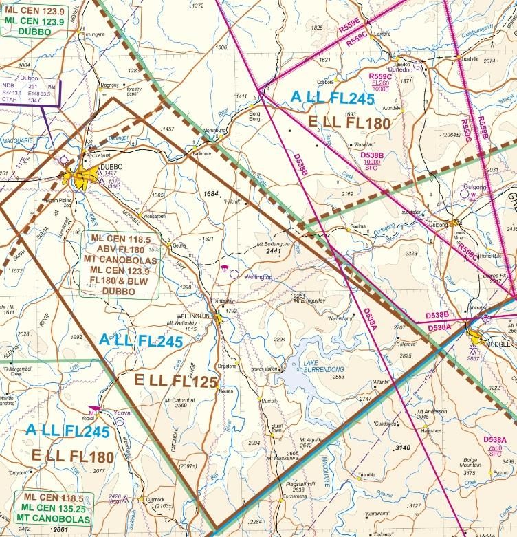
3.1.2 Dubbo aerodrome is located within Class G airspace and is designated as an
uncontrolled aerodrome where Common Traffic Advisory Frequency (CTAF) procedures
apply. Class E airspace with a Lower Level (LL) of Flight Level (FL) 125 is above the
aerodrome, stepping up to a LL of FL 180 in the airspace adjacent to the aerodrome. Class A
airspace is established above FL 245 (see Figure 1).
Figure 1: Extract of Newcastle Visual Navigation Chart (VNC)
(Airservices: Effective date 25 May 2017).
3.1.3 There are a number Restricted Areas (RAs) and Danger Areas (DAs) adjacent to the
Dubbo review area. Department of Defence is the controlling authority or nominated contact
for these areas. These areas have not been considered in this review given they are located
outside the review area.
3.2 Aerodrome
3.2.1 Dubbo is a certified aerodrome located five kilometres North West of Dubbo on the
Mitchell Highway (see Figure 2). The aerodrome supports regular passenger transport
services between Dubbo, Sydney, Newcastle, Canberra, Brisbane, Melbourne and other
western ports such as Cobar and Broken Hill. Passenger transport (PT) operators include
Regional Express (REX), QantasLink, Aero Pelican (Pelican) and JetGo.
3.2.2 Dubbo is one of busier regional aerodromes in Australia with approximately 40 PT
flights per day. The aerodrome is also home to a charter flight organisation called Airlink
which also provides the PT services on behalf of REX.
3.2.3 Dubbo is the regional headquarters for the Royal Flying Doctor Service (RFDS) and
supports general aviation, flight training and airfreight operations.
Preliminary Airspace Review of Dubbo – March 2018 Version: 1.0Office of Airspace Regulation Page 7 of 12
Figure 2: Extract of En Route Supplement Australia (ERSA)
(Airservices: Effective date 25 May 2017).
3.3 Air Navigation Service Providers in the vicinity of Dubbo
3.3.1 Dubbo is used by visual flight rules (VFR) and instrument flight rules (IFR) aircraft
and is an uncontrolled aerodrome subject to CTAF procedures in accordance with Civil
Aviation Regulation (CAR) 166. ATS in the controlled airspace above Dubbo are provided by
Airservices from the Melbourne ATS Centre. All aircraft within Class G airspace around
Dubbo are required to communicate using the CTAF 134.0 to enhance situational awareness
and reduce the risk of a mid-air collision. An Aerodrome Frequency Response Unit (AFRU)
provides confirmation to pilots that they are on the correct radio frequency.
3.4 Surveillance
3.4.1 Airservices has no radar coverage in the vicinity of Dubbo below 5,000 ft AMSL. The
Automatic Dependent Surveillance-Broadcast (ADS-B) area of coverage does not extend
below 5,000 ft AMSL in the vicinity of Dubbo. Therefore, there is no surveillance coverage of
any kind below 5,000 ft AMSL around Dubbo. There is limited and inconsistent ADS-B
coverage to the south west of Dubbo at 10,000 ft AMSL. Reliable surveillance coverage is
only available over Dubbo above FL150. The OAR determined that there is currently no
safety justification or risk to the safety of air navigation around Dubbo below FL150 that
justifies the need for additional surveillance coverage.
3.5 Dubbo aircraft movements
3.5.1 Total aircraft movements at Dubbo increased from 20,530 in March 2016 to
23, 503 in March 2017 (14% growth) growing a further 1,400 to an annualised result of
24,968 in September 2017. The growth has primarily resulted from an increase in PT
services. The OAR will monitor this trend in aircraft movements to ensure there are no future
risks to the safety of air navigation that result from increasing volume or complexity if aviation
activity. However, the Dubbo Airport Masterplan5 forecasts minimal growth in aircraft
movements until 2020.
3.6 Air navigation procedures
3.6.1 Airservices manages IFR aircraft operating in the vicinity of Dubbo inside Class E
airspace above FL125. These services are provided by Melbourne ATS Centre. An IFR
aircraft in Class E is separated from other IFR aircraft and are also provided with a traffic
information service as far as practicable on VFR traffic. All aircraft require a VHF radio and
must have a transponder. However, VFR aircraft do not require a clearance from air traffic
control to enter Class E airspace. Aircraft operating in Class G airspace in the vicinity of
5Aircraft movement forecasts for Dubbo Airport contained within Dubbo City Regional Airport Master Plan 2015 - 2036
Preliminary Airspace Review of Dubbo – March 2018 Version: 1.0Office of Airspace Regulation Page 8 of 12
Dubbo must do so in accordance with CAR166, “operations in the vicinity of an uncontrolled
aerodrome”.
4 AVIATION INCIDENTS
4.1 Summary of incidents
4.1.1 This review has determined there were 240 incidents in the review area between 1
January 2010 and 1 January 2017 (see Table 1) and 14 (5.7%) were categorised as airspace
related.
4.1.2 The 14 airspace related incidents were categorised as follows:
• Errors in pilot procedures,
• Failures in see and avoid procedures, and
• Communication failures.
4.1.3 Analysis of airspace incidents revealed that most incidents were caused by human
error and mainly related to pilots not using the correct frequency. The analysis also identified
issues generated by poor airmanship where pilots failed to communicate their intentions
resulting in runway incursions or other aircraft having to take avoiding action.
Year 2010 2011 2012 2013 2014 2015 2016
Airspace 1 2 2 1 3 3 2 14
Infrastructure 1 0 0 0 0 0 0 1
Consequential Events 1 0 0 0 0 0 0 1
Technical 7 2 8 4 6 4 5 36
Environment 16 13 18 22 17 14 26 126
Operational 5 10 7 5 6 6 9 48
Fuel Related 0 1 0 0 0 0 0 1
Powerplant/ Propulsion 0 0 3 1 5 2 2 13
Totals 31 28 38 33 37 29 44 240
Table 1: Dubbo Accident, Serious Incidents and Incidents.
5 KEY ISSUES AND FINDINGS
5.1 Issue: Aircraft operators raised concern about alleged incorrect position reporting by some
PT operators in order to manage the circuit traffic and obtain priority.
5.2 Finding: Local airspace users will give priority to PT aircraft if possible and safe to do
so. There was no evidence of this practice and the issue was not widely reported.
5.3 Outcome: This practice is not supported by the PT operators and they will ensure
that it does not happen.
5.4 Issue: Some local operators indicated that there were occasions where aircraft were
using the incorrect frequency (126.7 instead of the Dubbo discrete CTAF).
5.5 Finding: The OAR was unable to find any evidence of this issue but sufficent
feedback from local operators supported the view that there were occassions when aircraft
were using the wrong frequency.
5.6 Outcome: CASA safety education provide safety seminars and information sessions
to improve pilot awareness about radio communication and frequency selection in the vicinity
of an uncontrolled aerodrome.
5.7 Issue: The close proximity of Dubbo to Narromine aerodrome generated some
concern that situational awareness is being impaired due to the separate frequencies at each
location.
Preliminary Airspace Review of Dubbo – March 2018 Version: 1.0Office of Airspace Regulation Page 9 of 12 5.8 Finding: The option of developing a broadcast area with one frequency to cover both locations was considered but lacked support due to concerns over frequency congestion given Narromine often hosts sports aviation and gliding events adjacent to the Dubbo CTAF. 5.9 REX has established a local procedure to ensure they are vertically well clear of aircraft in the vicinity of Narromine when departing Dubbo. 5.10 Outcome: Local operators at Dubbo and Narromine should ensure that operators at each location are aware of the potential for aircraft to be operating on different frequencies in close proximity to each other and should consider the limitations of ‘see and avoid’. Airspace users at both locations should conduct regular airspace user meetings and attend the CASA safety seminars to identify and discuss risks caused by close proximity aerodromes and procedures. ERSA entries should include a notice to all operators at Dubbo and Narromine about the proximity of each aerodrome and publish any local procedures that may reduce risks to airspace users. 5.11 Issue: The OAR airspace modelling analysis highlighted a potential risk to the safety of air navigation, when aircraft operating within Class G airspace in the vicinity of the area navigation (RNAV) initial fixes to runway 05/23 at Dubbo may come into conflict with an aircraft flying the approach. 5.12 Finding: An airspace separation incident between a descending PT aircraft and an unidentified aircraft under the circumstances described above was reported to the ATSB. Whilst scant detail only was available the incident highlighted the potential risks to aircraft operating in Class G airspace adjacent to the CTAF in the vicinity of instrument approach waypoints and fixes. 5.13 Outcome: Operators at Dubbo should ensure that they are aware of the potential for aircraft to be operating on different frequencies in close proximity to each other and should consider the limitations of ‘see and avoid’. Airspace users should conduct regular airspace user meetings and attend the CASA safety seminars to identify and discuss these potential risks. ERSA entries should include a notice to all operators about the issue and publish any local procedures that may reduce risks to airspace users. 5.14 Issue: The RNAV approaches into Narromine and Dubbo overlap each other and aircraft each approach may be operating in close proximity to each other on separate frequencies. 5.15 Finding: The runway 29 RNAV approach into Narromine has not been published, therefore the issue no longer exists. 6 CONCLUSION 6.1 CASA has conducted an analysis of aircraft movements and incidents in the vicinity of Dubbo and concluded that the existing airspace architecture is fit for purpose. Feedback from airspace users around Dubbo indicated that an improvement in airmanship and frequency management would enhance situational awareness and safety in the region for all airspace users. 6.2 CASA will continue to provide education and safety information seminars at Dubbo to improve awareness by all airspace users about operations in the vicinity of a non-controlled aerodrome and to enhance awareness of issues related to the close proximity of Narromine aerodrome. There was insufficient support for the establishment of a broadcast area using a dedicated frequency to cover Dubbo and Narromine airspace users. Preliminary Airspace Review of Dubbo – March 2018 Version: 1.0
Office of Airspace Regulation                                                         Page 10 of 12

ANNEX A – ACRONYMS AND ABBREVIATIONS
 Acronym/abbreviation                  Explanation
 Act                                   Airspace Act 2007
 ADS-B                                 Automatic Dependent Surveillance - Broadcast
 Airservices                           Airservices Australia
 ALA                                   Aircraft landing area
 ALARP                                 As Low As Reasonably Practicable
 AMSL                                  above mean sea level
 ANSP                                  Air navigation service provider
 ASA                                   Aviation Safety Advisor
 ASIR                                  Aviation Safety Incident Report
 ATC                                   Air Traffic Control
 ATS                                   Air Traffic Services
 ATSB                                  Australian Transport Safety Bureau
 CASA                                  Civil Aviation Safety Authority
 CTA                                   Control Area
 CTAF                                  Common Traffic Advisory Frequency
 DA                                    Danger Area
 Defence                               Department of Defence
 Dubbo                                 Dubbo Airport
 ERSA                                  En Route Supplement Australia
 ft                                    feet
 FL                                    Flight Level
 GA                                    general aviation
 H24                                   24 Hours per day
 ICAO                                  International Civil Aviation Organization
 IFP                                   Instrument Flight Procedure
 IFR                                   Instrument Flight Rules
 IMC                                   Instrument Meteorological Conditions
 kt                                    knots
 Narromine                             Narromine Aerodrome
 nm                                    nautical miles
 OAR                                   Office of Airspace Regulation
 PT                                    passenger transport
 QRIR                                  Quarterly Risk Indicator Review
 RAAF                                  Royal Australian Air Force
 RA                                    Restricted Area
 RAPAC                                 Regional Airspace and Procedures Advisory Committee
 RNAV                                  Area Navigation
 SEG                                   Stakeholder Engagement Group
 VFR                                   Visual Flight Rules
 VMC                                   Visual Meteorological Conditions
 VNC                                   Visual Navigation Chart
 VTC                                   Visual Terminal Chart

Preliminary Airspace Review of Dubbo – March 2018                                     Version: 1.0
Office of Airspace Regulation                                                                                    Page 11 of 12

 ANNEX B – AUSTRALIAN AIRSPACE STRUCTURE
Class Description                     Summary of Services/Procedures/Rules
          All airspace above
                                      Instrument Flight Rules (IFR) only. All aircraft require a clearance
   A      Flight Level (FL) 180
                                      from Air Traffic Control (ATC) and are separated by ATC. Continuous
          (east coast) or FL 245
                                      two-way radio and transponder required. No speed limitation.

          Not currently used in Australia.
   B

          In control zones
                                      All aircraft require a clearance from ATC to enter airspace. All aircraft require
          (CTRs) of defined
          dimensions and              continuous two-way radio and transponder. IFR separated from IFR, VFR and
   C      control area steps          Special VFR (SVFR) by ATC with no speed limitation for IFR operations. VFR
          generally associated        receives traffic information on other VFR but is not separated from each other by
          with controlled
                                      ATC. SVFR are separated from SVFR when visibility (VIS) is less than visual
          aerodromes
                                      meteorological conditions (VMC). VFR and SVFR speed limited to 250 knots (kt)
                                      indicated air speed (IAS) below 10,000 feet (ft) Above Mean Sea Level (AMSL)*.

                                      All aircraft require a clearance from ATC to enter airspace. For VFR flights this
          Towered locations
                                      may be in an abbreviated form. As in Class C airspace all aircraft are separated
          such as Bankstown,
   D      Parafield, Archerfield,     on take-off and landing. All aircraft require continuous two-way radio and are
          Parafield and Alice         speed limited to 200 kt IAS at or below 2,500 ft within 4 NM of the primary Class
          Springs.                    D aerodrome and 250 kt IAS in the remaining Class D airspace**.IFR are
                                      separated from IFR, SVFR, and are provided with traffic information on all VFR.
                                      VFR receives traffic on all other aircraft but are not separated by ATC. SVFR are
                                      separated from SVFR when VIS is less than VMC.

                                      All aircraft require continuous two-way radio and transponder. All aircraft are
          Controlled airspace
          not covered in              speed limited to 250 kt IAS below 10,000 ft AMSL*, IFR require a clearance from
   E      classifications above       ATC to enter airspace and are separated from IFR by ATC, and provided with
                                      traffic information as far as practicable on VFR. VFR does not require a
                                      clearance from ATC to enter airspace and are provided with a Flight Information
                                      Service (FIS). On request and ATC workload permitting, a Surveillance
                                      Information Service (SIS) is available within surveillance coverage.

   F      Not currently used in Australia.

                                      Clearance from ATC to enter airspace not required. All aircraft are speed limited
   G      Non-controlled
                                      to 250 kt IAS below 10,000 ft AMSL*. IFR require continuous two-way radio and
                                      receive a FIS, including traffic information on other IFR. VFR receive a FIS. On
                                      request and ATC workload permitting, a SIS is available within surveillance
                                      coverage. VHF radio required above 5,000 ft AMSL and at aerodromes where
                                      carriage and use of radio is required.

 * Not applicable to military aircraft.
 **If traffic conditions permit, ATC may approve a pilot's request to exceed the 200 kt speed limit to a maximum limit of 250 kt
 unless the pilot informs ATC a higher minimum speed is required.

 Preliminary Airspace Review of Dubbo – March 2018                                                                Version: 1.0
Office of Airspace Regulation Page 12 of 12
ANNEX C – REFERENCES
• Aeronautical Information Publication – May 2017
• Airspace Act 2007
• Airspace Regulations 2007
• Australian Airspace Policy Statement – 2015
• DAP East – Effective 25 May 2017
• Designated Airspace Handbook – May 2017
• En route Supplement Australia – March 2017
• Dubbo City Regional Airport Master Plan 2015 - 2036
Preliminary Airspace Review of Dubbo – March 2018 Version: 1.0You can also read