PREPARING FOR TAKEOFF: HOW THE GOVERNMENT SECTOR CAN LEVERAGE DRONES - JANUARY 2020 - PWC
←
→
Page content transcription
If your browser does not render page correctly, please read the page content below
Preparing for takeoff:
How the government
sector can leverage drones

January 2020
Table of contents
1. Foreword........................................................................................................................ 3
2. Executive summary....................................................................................................... 4
3. Introduction.................................................................................................................... 5

4. Understanding drones................................................................................................... 6
   How do drones work?..................................................................................................... 6
   Types of drones.............................................................................................................. 7

5. How are governments deploying drones?................................................................... 8
   Industry use cases.......................................................................................................... 8
   Application of drones in various countries....................................................................10
   Application of drones in India........................................................................................14

6. How can the Indian government leverage this technology?......................................17
   Agriculture......................................................................................................................18
   Urban development.......................................................................................................19
   Traffic management...................................................................................................... 20
   Forest and wildlife..........................................................................................................21
   Healthcare..................................................................................................................... 22
   Homeland security........................................................................................................ 23
   Mining ...........................................................................................................................24
   Disaster management................................................................................................... 25
   Oil and gas.................................................................................................................... 26
   Telecom......................................................................................................................... 27
   Insurance...................................................................................................................... 28
   Tourism.......................................................................................................................... 29

7. Implementing drone technology................................................................................. 30
   Recommended action plan........................................................................................... 30
   Key considerations........................................................................................................31

8. Future roadmap for the government to create
   scalable solutions using drones................................................................................. 36

2 PwC | Preparing for takeoff: How the government sector can leverage drones
Foreword
Technology today has disrupted every facet of how                The UAV market in India is predicted to grow to
people work, live their lives and engage with others.            USD 885 million by 2021, with India soon becoming
While private businesses are being transformed by                one of the largest consumers of drone technology
technology, governments are also increasingly relying            in the world and thus the perfect destination for
on technological innovation to drive change and                  the global drone industry. For rapid and large-scale
improve governance.                                              innovation, the industry and regulators have to work
                                                                 together to develop a safe and scalable unmanned
One such technological innovation is the drone or
                                                                 aviation industry.
unmanned aerial vehicle (UAV), which is poised to
play a huge role in the government space. Today,                 The Central Government as well as various state
multiple governments across the world have started               governments in the country are moving ahead
using drones for tasks which previously required                 in leveraging this niche technology to enhance
physical presence/many people.                                   transparency and accountability. This technology has
                                                                 the potential to not just transform governance but
In India too, the Central Government, as well as
                                                                 also create ample job and business opportunities in
some state governments, has taken up pilot projects
                                                                 the country.
to demonstrate use cases and evaluate the use of
drones for their specific requirements.                          As an industry-led professional body, we are happy
                                                                 to bring out this white paper in association with
With the launch of a policy on drones, the
                                                                 PwC. We hope that this paper helps in increasing
Government of India has taken the first step to
                                                                 awareness of drone technology, its applications and
regulate and monitor drone usage and operations in
                                                                 policies among government stakeholders. Clear
the country. The provisions of the policy, together with
                                                                 understanding of this technology will help to build a
the Digital Sky Platform, are sure to usher in a new era
                                                                 sustainable UAV industry in the country.
of drone-enabled operations in various facets of life.

Sreeram Ananthasayanam                                           Rahat Kulshreshtha
Partner, Government and Public Sector                            President
PwC India                                                        Drone Federation of India

                                                        3 PwC | Preparing for takeoff: How the government sector can leverage drones
Executive summary
Technology is changing the face of the world in
multiple ways, and industries across the globe have
been defining new ways to do business by utilising
these technological advances.
One such next-generation technology is UAVs/drones,
which are increasingly gaining attention. Multiple industries
are utilising drones for myriad tasks—from surveillance to
monitoring of projects, from detection to prevention, and
from improving current methods/processes to transforming
and innovatively handling new requirements.
Governments too have started embracing this next-
generation technology for improving governance, reaching
out to citizens, and leading their country’s transformation
to greater agility, responsiveness, and transparency.
This paper looks at the technology aspects of drones and
the various components that constitute the machine. It
details various use cases that have been piloted across the
globe and in India, specifically in the government sector. It
then details various ways in which governments in Indian
states could utilise drones in specific sectors, ranging from
agriculture to tourism.
Finally, it recommends an approach that the government
sector can follow for successfully utilising this innovative
technology, along with the key considerations to select
the right type of drone(s) for a specific use case.

4 PwC | Preparing for takeoff: How the government sector can leverage drones

Introduction
Unmanned aerial vehicles (UAVs), more commonly                   India recently released regulations for the use of drones for
referred to as ‘drones’, are basically aircraft without          commercial purposes, under which licence requirements
human pilots that have been in operation since the               are defined based on the weight and flying height of the
early 1900s. Though initially used only for target               drones. Also, restrictions have been placed on flying
practice by military groups, they were later equipped            drones near airports and sensitive establishments.
with real-time surveillance capabilities to monitor troop        Privacy and protection of personnel, property and data
movements behind enemy lines.                                    are given due importance.
With the digital revolution bringing in tiny microprocessors     According to the regulations,2 rules are defined for the
and abilities for long-distance communication, the role          drones on the basis of their weight:
of drones expanded to not only more specialised military
operations but also civilian applications. In recent years,       Weight classification             Drone category
the market for drones has grown dramatically with a
                                                                  250 gm and 2 kg and 25 kg and 150 kg                           Large drones
this technology beyond their traditional use for defence
purposes, and to widespread non-military commercial use          Nano drones can fly up to 50 feet and would be exempt
ranging from photography to pizza delivery.                      from seeking one-time approval, including a Unique
Despite innumerable uses and the high level of acceptance        Identification Number (UIN).
of this technology, governments the world over continue
to face the challenge of striking the right balance between
adoption of drones and ensuring the safety, privacy and
security of their citizens.

                                                        5 PwC | Preparing for takeoff: How the government sector can leverage drones
Understanding drones

  How do drones work?
  Operationally, a drone can either be (1) remote controlled by a pilot sitting out of a remote location or (2) pre-
  programmed to operate automatically without any human intervention.

                                                                      Components of a drone

             Remote controlled drones

A transmitter is used to send radio signals to the receiver
inside the drone, which interprets the signal and transmits
it to the flight control board and subsequently to electric
speed controllers (ESCs) for action.3 An ESC is an electric
circuit responsible for varying motor speed and direction;
                                                                                 Electric speed controller (ESC)4
these controllers also act as a dynamic brake.
                                                                                 Controls the amount of voltage received by
                                                                                 the motors, in order to control the speed
                                                                                 of each propeller. This system allows the
                                                                                 drone to manoeuvre.

             Pre-programmed drones                                               Battery
                                                                                 Lithium polymer (LiPo) battery is
Drone Waypoint GPS Navigation is an advanced satellite                           rechargeable and light, and provides
navigation device that allows a drone to fly on its own,                         power to electric motors.
with the flying destination or points pre-planned and
configured into the remote control navigation software.                          Flight control board
It instructs a drone where to fly, at what speed, and at                         Receives information from the receiver and
what height, and can also be configured to hover at each                         sends signals to electric speed controllers.
of the defined points.
There are two ways of piloting a drone – either through line
of sight (visual observation) or through first person view                       Electric motor
(FPV). In the case of first-person view, the drone transmits                     Converts electrical energy
a video image from an on-board camera through radio                              into mechanical energy.
frequency, which is received on the ground on a personal
video display (screen/video goggles)
                                                                                 Transmitter (TX)
In terms of the data activity flow, ‘data capture’ is done
                                                                                 Enables user to control aircraft from a
during flight time through remote pilot or GPS. This data
                                                                                 distance using radio signals.
is then stored and transferred from the drone to the base,
and then analysed to draw insights.

                                                                                 Propeller
                                                                                 Blades/fans generate power through
                                                                                 conversion of rotational movement to either
                                                                                 lifting or forward movement

                                                                                 Receiver (RX)3
                                                                                 Intercepts radio signals from the TX and
                                                                                 converts them into alternating current
                                                                                 pulses which produce information that is
                                                                                 transmitted to the flight control board.

6 PwC | Preparing for takeoff: How the government sector can leverage drones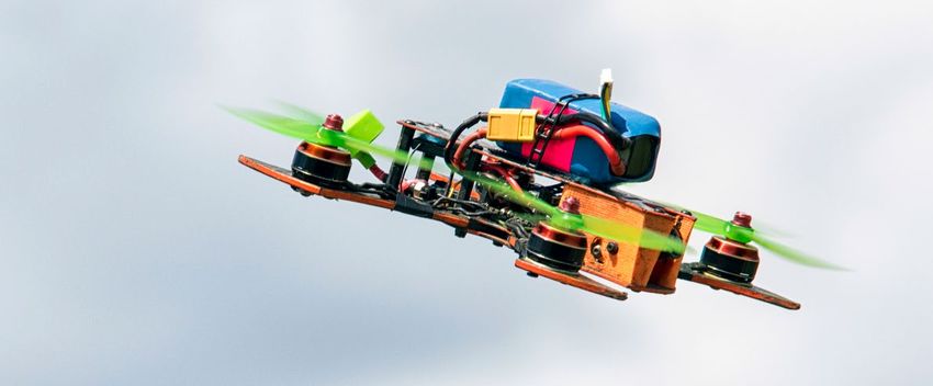
Some of the other components that assist in the operation         Magnetic sensors: Electronic compasses provide critical
of drones are listed below:                                       information to inertial navigation and guidance systems.
Gyroscope: Three and six axis gyro stabilisation
technology provides navigational information to the flight        Types of drones
controller to ensure flying and hovering are stable. It
                                                                  Although drones come with different state-of-the-art
measures angular velocity and orientation.
                                                                  technologies packed into their lightweight frames, they
Accelerator: It determines the position and orientation           vary considerably in terms of size, weight, payload
of a drone in flight. Accelerators have thermal sensing           capacity, flight time and functionality, depending on the
capabilities, which play an important role in stabilising on-     purpose for which they are being deployed. The weight
board cameras.                                                    of the drone and the battery attached are important
Inertial measurement units (IMUs): IMUs use                       determinants of its flight time.
magnetometers (compasses) that sense changes in                   There are primarily two types of drones: (a) fixed-wing
direction and feed data into processors to indicate               drones and (b) rotary drones. Rotary drones can either be
direction, orientation and speed.                                 single-rotor drones or multirotor drones.
Tilt sensors: Combined with gyroscopes and accelerators,          Drones are often loaded with various sensors, such
they provide input to flight control systems for maintaining      as in-built GPS navigation systems, TV cameras,
flight level. These are essential for applications requiring      image intensifiers, radars, infrared imaging equipment
high stability—for instance, in cases of surveillance or for      and lasers to help round-the-clock monitoring and
delivering fragile goods.                                         targeting. Drones for military use are also equipped with
Current sensors: They monitor and optimise power drain,           laser-guided missiles.
safe charging of internal batteries and detect faults with
motors or other parts of the system.

 Parameters                        Fixed wing                       Single rotor                       Multirotor

 Weight                            Heavy                            Heavy                              Light

 Payload capacity                  2 to 5 kg                        3 to 15 kg                         2 to 10 kg

 Flight time                       1 hour or more                   1 hour or more                     20–45 minutes

 Hovering capabilities             Cannot hover                     Can hover                          Can hover

 Expertise required                Hard to fly                      Very hard to fly                   Easy to use

 Key uses                          Large area survey                Area survey and mapping,           Surveillance,
                                   and mapping                      spraying applications              photography, inspection

Note: The above parameters are defined and projected based on commercial applications only.

                                                         7 PwC | Preparing for takeoff: How the government sector can leverage drones
How are governments
deploying drones?
  Due to ease of operations, limited human intervention and accuracy of results generated, drones have widespread
  civilian applications. They are currently being used across the world for bringing transformational changes in the
  fields of agriculture, urban planning, disaster management, infrastructure, transport, surveillance, mining, forestry
  and many others.

Industry use cases

              Agriculture                                                         Urban development

• United States: Precision farming – assessing optimal                • Singapore: Developing 3D models for heritage sites
  quantity of water and fertilisers to be used                          to guide restoration work
• China: Spraying pesticides on crops                                 • Gurugram, India: Geo-referencing for land
• Netherlands: Detection of cannabis on fields                          records management

• Gujarat and Rajasthan, India: Land and crop health monitoring       • Chennai, India: Digital mapping for accurate
                                                                        property tax collection
• Andhra Pradesh, India: Soil testing

              Transport                                                           Forest and wildlife

• United States: Inspection of railway lines under construction       • Kenya: Aerial monitoring to prevent illegal
  or maintenance                                                        poaching of elephants
• Germany: Railway infrastructure monitoring to                       • Australia: Surveillance of swimming spots to
  combat graffiti-spraying gangs                                        prevent unexpected shark attacks
• United Kingdom: Detecting and fixing                                • Pench National Park, India: Aerial monitoring of forests
  potholes on roads                                                     to control poaching and tree felling
• Iran: Road traffic surveillance to make                             • New Delhi, India: Central government plans to
  decongestion plan                                                     use drones for tiger census
• Mumbai, India: Highway traffic monitoring and
  penalising for traffic rules violations

              Healthcare                                                          Security

• African countries – Rwanda and Tanzania: Medical                    • United States: Security provision at Boston Marathon;
  deliveries of blood units, vaccines and contraceptives                drones are deployed at various sporting events
• United States: Transportation of blood samples to labs
  for testing
• Tanzania: Monitoring and assessing malaria
  vector habitats

8 PwC | Preparing for takeoff: How the government sector can leverage drones
Disaster
            Mining                                                            management

• Philippines: Monitoring and auditing mining firms             • Drones were deployed during Typhoon Haiyan in
• Australia: One of the mining companies using drones to          Philippines, Hurricane Sandy in Haiti, flooding in
  inspect their equipment and mining pits                         the Balkans and the earthquake (2008, 2014, 2015
                                                                  and 2016) in China
• Gujarat, India: Monitoring inaccessible areas around
  the Sabarmati bed to track illegal sand mafia                 • Europe: Drones were found to isolate people much
                                                                  faster than traditional ground-based rescue teams

            Oil and gas                                                       Telecom

• Norway: An oil and gas company used remote-                   • United States: Inspecting cell sites in difficult
  controlled drones to inspect its gas processing plant           to reach areas or disaster-affected areas for
• Oklahoma, United States: A multinational conglomerate           information on damaged equipment
  used drones equipped with infrared cameras to identify        • United States: Assessing damage to telecom
  leaks in the gas pipeline 5                                     infrastructure post Hurricane Harvey and manage
• Madhya Pradesh, India: GAIL has deployed drones on a            repair efforts
  pilot basis for aerial surveillance of the HBJ pipeline in    • Texas, United States: One of the largest
  Chambal ravines 6                                               telecommunication firms used drones to
                                                                  inspect telecom towers

            Insurance                                                         Tourism

• United States: Damage assessment for claims in the            • Norway: The tourism board has commissioned drone-
  aftermath of Hurricane Harvey. Also, conducting home            based video to showcase the beauty of the city of
  assessments for quick claim settlements.                        Trondheim and its outskirts
                                                                • Australia: The health of the Great Barrier Reef is being
                                                                  monitored using drones
                                                                • Corbett National Park, India: Monitoring of tourists to
                                                                  ensure minimal disturbance to wildlife

                                                       9 PwC | Preparing for takeoff: How the government sector can leverage drones
Application of drones in various countries

  Tanzania

The Government of Tanzania is exploring the application of drones primarily for inspection and monitoring purposes.
Some of the key use areas are listed below:

          Disaster management                                                   Healthcare

To enhance geospatial mapping during natural disasters                The Government of Tanzania is planning to initiate the use
like floods, Tanzania is using GPS-enabled technology                 of drones for delivering medicines to meet unexpected
which assists in gathering substantial information on                 demands, ensure delivery in bad weather, critical situations
floodplains and the movement of water to avoid loss of                and in case of any unforeseen disaster.
life and property.

                                                                                Wildlife
          Land mapping
                                                                      Drones are being deployed in Tanzania’s national parks
Drones are being deployed to help in land mapping in rural            to curb poachers and poaching activities, thus saving the
areas to avoid clashes between farmers and cattle herders             lives of thousands of animals and birds who live or take
over natural resources like land and water. Through aerial            refuge in these areas.
surveys, drones capture high-resolution images, which the
government can use to identify as well as digitise actual
boundaries of disputed land.

  Canada

Drones are being extensively deployed by the Government of Canada to assist the police and maritime operations. Some
key use cases are listed below:

          Police operations                                                     Wildlife

Canada’s Police Department is extensively using drones                Many wildfire services in the country, such as BC Wildfire
to efficiently conduct various police operations such as for          Service and Alberta Firefighting Service, have been using
probing traffic collisions, searching for missing persons,            UAVs for recon missions, smoke and fire detection, ranging
and investigating robberies and homicides.                            operations and rescue operations as well.

10 PwC | Preparing for takeoff: How the government sector can leverage drones
Maritime operations Agriculture
The National Research Council7 of Canada has partnered In agriculture, drones are being increasingly deployed to
with Transport Canada, the Canadian Coast Guard and gather farm and crop-specific data which assists farmers
the Royal Canadian Navy to explore, demonstrate, and in boosting farm productivity.
evaluate the potential of UAVs in coast guard ice-breaking
and maritime ice-monitoring operations. UAVs add
tremendous support to marine operations by providing
beyond visual line-of-sight situational awareness of ice
conditions and prominent ice features such as ridges and
shear lines, further improving response and monitoring
capabilities in the industry.
Dubai
Dubai, being the centre of UAV deployment in the UAE, is applying drones in multiple areas. Some of the key use cases
are listed below:
Police operations Firefighting
Drone technology has been heavily incorporated in Dubai Drones in Dubai are being tested to lift heavy firefighting
police operations to monitor traffic and provide live data on equipment on to high-rise building floors. The Department
areas with traffic congestion and in which traffic accidents of Civil Defense has also been testing drones to patrol
occur. Drones have also been used to identify faces of high-risk areas, such as industrial zones, and to monitor
criminal in heavily populated urban areas. For bomb and record fires.
disposal missions, the police has been using drones with
water cannons mounted on them to disburse crowds.
Crowd monitoring
Real estate
The Government of Dubai has been using drones to
Across the real estate industry, drones are being used to monitor for littering. People who litter are identified with the
monitor construction activity as they can produce detailed help of cameras mounted on drones and are immediately
rectified orthophotos and topographic maps which are fined for not observing rules for cleanliness.
much clearer than conventional surveys.
Waste management
Dubai’s Waste Management Department has successfully
deployed drones in areas such as beaches and landfill
sites to spot people who litter.
11 PwC | Preparing for takeoff: How the government sector can leverage dronesApplication of drones in various countries
Singapore
Singapore has started its Smart Nation project, which intends to exploit smart technology to create new opportunities and
transform the way people live. The Singapore government believes that drone technology plays an important role in the
transformation of sectors such as infrastructure, public safety, disaster management and farming. Some key use cases for
drones in the public sector are listed below:
Maritime operations Firefighting
The Maritime and Port Authority of Singapore has been Drones, being cheaper than manned aircrafts, are
using drones to better assess oil spills and monitor its deployed by the fire department to replace manual recon
part of the ocean. In addition, drones will soon be used missions and ensure safer and more efficient firefighting.
for inspecting incoming ships in a cheaper, safer and less
time-consuming manner than manned surveys.
Delivery
Healthcare The Singapore government has deployed drones as a
replacement for the manual mailman service. Singapore
Drones are being used to conduct surveys of mosquito- successfully performed the world’s first delivery of mail by
infested areas and mosquito breeding sites to combat drone. A test flight was conducted to send a letter and a
diseases like dengue. parcel (a T-shirt), for which the drone crossing from one
island to another.
United States
The United States has been at the forefront of testing and adopting drone technology. Some of the key use cases for
drone implementation are listed below:
Search and
Railway inspection rescue operations
The Federal Aviation Administration has identified the Drones are being deployed to conduct search and rescue
inspection of network railway lines as one of the cases operations to track missing hikers in the Grand Canyon.
for the testing of commercial use of drones. Manned Also, during Hurricane Harvey, drones were used to spot
inspection is inconvenient and expensive, and inspectors people in urgent need of help and to deliver rescue ropes
have to deal with insects, toxic vegetation or poisonous and life jackets in dangerous areas.
snakes. The use of drones will allow for more frequent
track inspection which will help in reducing derailments,
hence preventing rail accidents and reducing loss of life.
The administration is also using drones to inspect bridges,
especially the area underneath them, and in some cases
even trains themselves.
12 PwC | Preparing for takeoff: How the government sector can leverage dronesTelecom infrastructure
Precision agriculture inspection
Drones are being tested for use in precision agriculture, Tropical Storm Harvey disrupted 17 emergency call centres
to reduce misapplication of limited resources (water, and 320 cellular sites, and caused massive outages for
fertilisers and chemicals) and thereby improving crop Internet, TV and phone users, making it difficult for people
and farm efficiency. to contact their families and friends. To re-establish
connectivity quickly, drones were used for not just
assessing the point of damage but also ascertaining the
best route to access the site and supply the equipment
Security and surveillance
required to fix the damage.
Drones are increasingly being deployed to monitor
events, concerts and other high footfall programmes to
continuously track crowd movements and identify any
suspicious activities.
United Kingdom
The application of drones is being tested in various parts of the United Kingdom in multiple industries. Some of the key
use cases are listed below:
Inspection and repair Healthcare
The use of drones in inspecting, diagnosing and repairing Certain government health institutions in England are
potholes, street lights and utility pipes is being tested in exploring the use of drones to assist hazardous area
England. This would assist in the timely identification and response teams, who deal with medical emergencies
fixing of small defects and thus pre-empting any large involving chemical, biological or nuclear materials. The
failure or inconvenience. possibility of using drones to deliver blood or organs for
transplant is also being looked at8.
Oil and gas
Drones are increasingly being deployed to inspect offshore
oil and gas infrastructure, which is dangerous, time-
consuming and costly to inspect using traditional methods.
13 PwC | Preparing for takeoff: How the government sector can leverage dronesApplication of drones in India
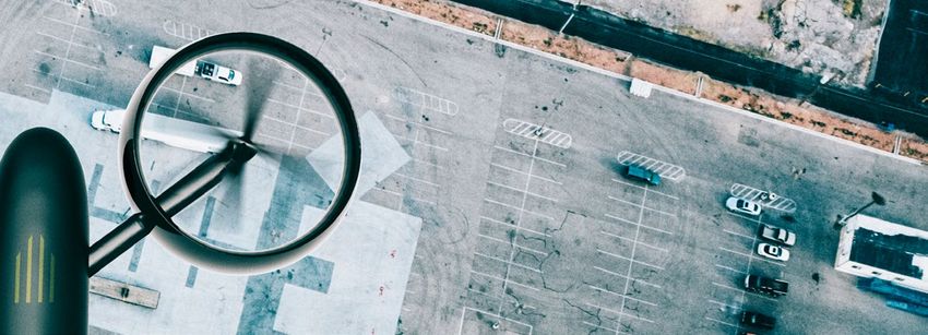
Urban development Forest
• The Government of Andhra Pradesh is deploying • The Haryana Forest Department has inducted two
drones to monitor the development activities of the drones to monitor wildlife and prevent illegal activities
capital city region, i.e. Amaravati, through drone- like tree cutting, encroachment and road construction
based outputs such as geo-referenced ortho-images, in the Aravalli Range.11 The drones are equipped
digital elevation models and 3D models at periodic with night vision cameras and flown up to a height of
intervals. This covers the progress of multiple projects 250 m with a speed of 60 mps.
in and around the capital city area, such as roads, • The Government of Maharashtra has deployed
buildings and other infrastructure-related activities. drones to enhance the transparency and credibility
• The Government of Andhra Pradesh has deployed of forest governance.12 It approved the use of drones
drones to map and assess the green cover in three to track the health of forests, encroachments, tree
selected locations in the state, thereby enabling felling, forest fires, poaching, status of water bodies,
the government to take necessary measures biodiversity protection, and mangrove conservation.
for maintaining the greenery in those locations. • The Government of Tamil Nadu has deployed five
Subsequently, the government has planned to spread drones (in the Nilgiris, Coimbatore, Dindigul, Hosur
this activity across the state and make Andhra and Tirunelveli) equipped with thermal detectors
Pradesh a green state. and infrared rays for real-time monitoring of animal
• As a pilot project, the Government of Karnataka is movement and to prevent the spread of forest fires.
deploying drones for property tax estimation and Also, the buzzing sound created by drones at 131
creation of base map of a city/town for detailed decibels is used to drive away elephants, which
planning and sustainable governance. normally requires the effort of 50–80 individuals.13
• The Chandigarh Administration has deployed • In August 2015, the Union Ministry of Environment,
drones as part of pilot project to get an aerial view Forest and Climate Change cleared a project14 by
of all properties in Chandigarh. The main aim was the National Tiger Conservation Authority (NTCA)
to map each and every dimension of all properties and Wildlife Institute of India (WII) to deploy drones
in and around Chandigarh, which would enable in select forests around the country for monitoring
administrators to detect building violations and and surveillance.
encroachments.9
• The Government of Tamil Nadu has deployed
drones in Chennai for mapping property tax and
encroachment of government land. The processed
data would also enable officials to estimate the actual
property tax10 and levy penalties on owners who have
illegally paid lower dues. In addition, drones will help
authorities plan for disaster management.
14 PwC | Preparing for takeoff: How the government sector can leverage dronesTransport Agriculture
• Indian Railways has used drones for monitoring • A general insurance company deployed drones in
the 25-km long Seawoods-Belapur-Uran15 corridor. a particular district in Maharashtra for assessment
Drones are being used to capture and analyse data. of crop damage due to floods in 201618, instead of
The outputs and insights have helped railway officials deputing its personnel to visit the field and assess the
to present the project progress to their decision crop damage.
makers without undertaking field visits.
• The Government of Maharashtra has deployed drones over
• The National Highways Authority of India (NHAI) fields in the Marathwada19 region for carrying out crop loss
has deployed drones in the Salem-Chennai green assessment due to deficit rainfall, thereby ensuring timely
corridor expressway project to ensure accuracy with intervention and compensations to farmers. Based on the
respect to the extent of land required for the project.16 successful results, the government has proposed mapping
This survey was aimed to estimate the affected 51 villages of the Marathwada region under a pilot project.
number of coconut, palm and mango trees, other
• As a pilot project, the Government of Karnataka
crops and properties.
is deploying drones for identification of crop type,
• As a pilot project, the Government of Maharashtra has estimation of crop acreage, assessment of crop health
deployed two drones to monitor weekend rush hour and crop yield forecasting by establishing standard
traffic and accidents on the 95-km stretch between operating procedures that are envisaged to be followed
the Lonavala Exit and Khalapur Toll Plaza17 and on by the agriculture department in Karnataka.
the six-lane Mumbai-Pune Expressway. The drones
are flown at an altitude of 30 m from 12 p.m. to 4 p.m. • The individual farmers of Andhra Pradesh’s capital
Based on the data collected, 15 trucks were fined for region are deploying drones to spray crop pesticide/
violating traffic rules. fertiliser in limited crop areas. Based on the results,
famers are planning to extend this mechanism to
other crops and areas.
15 PwC | Preparing for takeoff: How the government sector can leverage dronesApplication of drones in India
Disaster management Security and surveillance
• The National Disaster Management Authority • The Crime Branch of the Thane Police Department
(NDMA) deployed four drones to scan areas where deployed drones to confirm suspicions and gather
search and rescue teams could not access in evidence of bootlegging in a village.25 The drones
flood-hit Uttarakhand. These drones carried out a identified three locations and drums, planks, mixing
reconnaissance of 5020 locations to assess damage. tubs, furnaces, raw materials, etc., and thus helped the
Further, the State Disaster Management Authority has department officials to conduct raids.
procured a fleet of 10 drones for rescue operations.
• As part of a pilot project, the Government of Karnataka
• The National Disaster Relief Force used drones in is using drones for crowd and traffic surveillance
Mandi,21 Himachal Pradesh, to trace 24 engineering for effective planning decisions by the state police
students from Hyderabad who were swept away by department. In addition to surveillance, the police
the Beas river. department is also performing video analytics.
• The National Disaster Relief Force has deployed drones • The Tamil Nadu Police Department may be the first
to survey the landslide site at Malin in Ambegaon force in the country to deploy drones for murder
taluka.21 The drones covered a 2.5 km radius and live- investigation, in an area that was inaccessible and
streamed visuals to the control room. covered with thick bush. Two drones weighing 1.5 kg
and 10 kg were used for 6 hours to reconstruct the
• The National Disaster Relief Force used drones to help
crime scene by creating 3D images.26
their teams spot stranded people in forests, hills and
other isolated areas who were dislocated from Badrinath
and Kedarnath during the Uttarakhand floods. Around
190 stranded people22 were spotted by drones. Mining
• During the Nepal earthquake, several agencies
deployed drones for search and rescue operations and • The Government of Andhra Pradesh deployed a drone
to map toppled monuments,23 ruined heritage sites and for monitoring of stockpile storage, 3D mapping and
devastated homes. volumetric analysis of limestone over a period of time.
• The Karnataka Police Department has procured and
deployed 12 drones equipped with 18.2 MP cameras
Oil and gas and night vision capability which fly at an altitude
of 1 km for about 30 minutes to detect illegal sand
mining27 from 5 km away.
• GAIL (India) Limited has deployed drones on a pilot
basis for aerial surveillance of its pipelines in Chambal • In Jharkhand, drones are deployed for boundary
ravines24 in Madhya Pradesh. They are used to patrol and safety zone inspection of coal and iron mines,
the gas pipeline and detect abnormal physical activity counting of vegetation in reclaimed areas, and
like encroachment or intrusion. profiling of quarry and dump for volume calculations.28
16 PwC | Preparing for takeoff: How the government sector can leverage dronesHow can the Indian government
leverage this technology?
India is a geographically diverse country with a majority of its population residing in rural areas, some of which are
remote or hard to access. Thus, at times, they deprived of essential services. Drones can be used to substantially
impact public service delivery and governance, improving vital indicators across all fields.
Tourism Agriculture
Insurance Urban development
Telecom Traffic
Potential use cases
Oil and gas Forest and wildlife
Disaster management Healthcare
Mining Security
Some of the key sectors where drones can be effectively deployed by
the government are discussed in the following sections.
17 PwC | Preparing for takeoff: How the government sector can leverage dronesThe agriculture sector in the country is plagued by issues of
plateauing yield, imbalanced use of fertilisers, over-exploitation of
groundwater and improper irrigation. Besides this, crop diseases,
pest attacks and degradation of soil fertility further reduce the
agricultural output. Lack of mechanisation for timely detection of
Agriculture
these issues and course correction, farmers often suffer significant
losses, which severely affects their already low purchasing power.
How can drones help?
Crop health monitoring
Routine surveillance using high-resolution, geo-referenced,
orthomosaic 2D maps, spectral imagery and visual imagery
can be used to capture the growth cycle and assess crop A pest attack on
health to detect any potential problems swiftly as well as to
assess damage and contain crop losses. Site-specific crop
50%
of the cotton crop led to
damage reports can be generated for appropriate action.
Maharashtra losing
This will help governments to ascertain an appropriate
compensation plan for farmers. 15,000
crore INR.29
Soil health assessment
Soil quality can be monitored using parameters such as
soil moisture through remote sensing, which can help
develop fertility maps, and consequently assist in planning
for more optimal crop rotation or irrigation.
Improved resource utilisation There were
Ascertaining areas within a field that are most fertile or 1,895
those that require additional water/fertilisers or chemicals
farmer suicides in
can help farmers to optimise their resource utilisation.
Orissa between
These limited resources can accordingly be deployed in
2005–14, indicating
different parts of the field in different quantities.
a looming crisis.30
18 PwC | Preparing for takeoff: How the government sector can leverage dronesThe increase in population has heightened the demand for
housing and other infrastructure. It has, therefore, become
essential that smart solutions are implemented for urban
city planning. To achieve this, clear visibility on land usage
is required to put in place sustainable expansion plans,
Urban
which becomes difficult with the existing technology.
development
How can drones help?
City survey
Geo-referenced, orthomosaic maps processed from
high-resolution aerial images can be deployed for land
use monitoring and mapping to ascertain wet lands or Karnataka has the highest
kharab lands. Illegal land encroachment can also be number of incidents of
detected in this way. forest encroachment in
India, with a total of
Improved urban planning
Increased visibility of developmental and expansion
187,000
hectares of forest found
activities with accurate alignment of roads, canals and to be encroached.31
drains can assist in urban planning. Moreover, digital
elevation models help in understanding terrain stability
while planning highways or residential ventures.
Project monitoring
Thorough inspection and monitoring of
construction projects for bridges, buildings,
telecom towers, etc., can be undertaken to
assess their delivery status, and plan any
corrective action if required.
Project quality assessment
Thermal imagery, 3D virtual models and videography can
help to ascertain the stability of critical structures built,
while time-lapse records can help analyse planned work
versus executed work.
19 PwC | Preparing for takeoff: How the government sector can leverage dronesThe population explosion has dramatically increased the
number of on-road vehicles, leading to intense traffic congestion,
especially during peak office hours. Besides this, severe
waterlogging occurs across cities during the monsoons,
further worsening traffic condition.
Traffic
management
How can drones help?
Road surface condition monitoring
Roads with heavy traffic movement can be routinely
inspected to identify potholes or waterlogged areas, which
often lead to accidents. For example, a drone can monitor
the Delhi-Chandigarh or Bengaluru-Mysuru highway and
Potholes killed
provide a quarterly report on road condition. This data can
be used by the Public Works Department for tendering 11,386
maintenance contracts. people between
2013–16.32
Improved traffic management
City traffic maps can be created to get real-time
information on traffic jams, accidents, etc., which will help
in planning appropriate diversions to decongest specific
areas. Furthermore, video analytics is expected to drive
decision making and assist in traffic management and
route planning.
Traffic in Whitefield,
Bengaluru, and ORR
Traffic feedback costs the IT industry
Real-time information on both vehicular and pedestrian
traffic movement and congestion will enable evidence- 22,000
based decisions on new roadway constructions, traffic crore INR/year. As a
signal requirements, pedestrian signal requirements, etc. result, companies are
considering relocating
outside the city.33
20 PwC | Preparing for takeoff: How the government sector can leverage dronesIndia is home to a large number of tigers, leopards, panthers
and elephants. Though it welcomes a large number of
tourists to its many national parks and reserves every
year, it continues to struggle to maintain its wildlife and
forest areas, with multiple cases of illegal poaching being
Forest and
registered every year.
wildlife
How can drones help?
Wildlife conservation
Poaching and illegal trade can be curbed through round-
the-clock monitoring of threatened species in national
Over
parks (e.g. Bandipur, Ranthambore).
1,00,000
forest fires were reported in
Managing human-wildlife conflict
India between 2011–16, with
Regular surveillance of both protected and unprotected over
forest areas for wildlife movement will reduce the
possibility of human and wildlife conflict. 54%
of forest area
prone to fires.34
Forest protection
Heat maps generated through thermal sensors can detect
forest fires, while time-lapse studies of forest cover can
highlight deforestation, afforestation and encroachment.
India accounted for
30%
of the world’s tiger seizures
between 2000–2015.35
21 PwC | Preparing for takeoff: How the government sector can leverage dronesSome of the challenges that plague the healthcare space include
establishing and maintaining the right infrastructure, ensuring a
robust public health delivery system for all citizens, ability to actively
manage disease programmes using high-quality data for scientific
decision making, and maintaining the general well-being of citizens
Healthcare
by offering a clean and healthy environment.
How can drones help?
Epidemic control
Thermal imaging, combined with topographic, weather
and population density data, can help in developing heat
maps to ascertain breeding zones for mosquitoes carrying Chikungunya cases
dengue, malaria, chikungunya, etc. have increased by
390%
Cleanliness and hygiene in India over a
Information on exposed garbage piles, open drains and period of
sewers, dead animals on roads, etc., can be captured and
used to control health hazards.
3
years.36
Healthcare delivery
India, with its varied topography from hills to dense forests
to marshy river deltas, can use drones for timely delivery of
essential medicines, test kits and vaccines to these hard to
reach areas.
22 PwC | Preparing for takeoff: How the government sector can leverage dronesThe metro cities in India host multiple public events for
which security planning requires considerable time and
efforts. Moreover, real-time monitoring of crowds at these
large gatherings, along with strategic security deployment,
is often challenging.
Homeland
security
How can drones help?
Real-time surveillance
Crowd monitoring can be done at public events such
as political rallies, concerts, and exhibitions, and during
religious festivities for identification of any suspicious or
potentially unsafe activities or situations.
Security planning
3D models can be constructed for a location to conduct
safety planning, identify traffic diversion routes and map
deployment of security personnel across the area.
23 PwC | Preparing for takeoff: How the government sector can leverage dronesIndia continues to face significant challenges in tracking, monitoring
and curbing illegal mining activities, limiting encroachment on
mining boundaries, and keeping a check on the illegal sand mafia.
Mining
How can drones help?
Mineral scouting
Visual, hyperspectral and thermal sensors assist in mineral
scouting for type of mineral available and the location.
They also help in quantity estimation of mineral extraction.
Mafia and illegal mining
Managing encroachment cause losses of
Routine monitoring can help detect mine boundary 12 crore INR
violations and check the activities of the illegal sand mafia. a month.37
Contract monitoring
Mining contracts, based on volume of minerals
extracted, can be monitored using aerial photos taken
at separate time intervals for effective enforcement and
implementation.
24 PwC | Preparing for takeoff: How the government sector can leverage dronesIndia has multiple remote and inaccessible areas due to
their unique topography and hence requires robust disaster
management systems and processes to control loss of life
and property in the event of a natural calamity.
Disaster
management
How can drones help?
Real-time surveillance
High-resolution live video feed of disaster-struck areas can
be used to create 3D models for efficient decision making.
Search and rescue
Heat maps can be generated to determine the exact
locations of survivors and livestock for effective
rescue operations.
Delivery of essential goods
In hard to reach disaster-struck areas, food supplies,
water, medicines, etc., can be dropped quickly without
endangering more human lives. This will also result in
significant cost and time savings as compared to a
manned aircraft system.
25 PwC | Preparing for takeoff: How the government sector can leverage dronesOnshore and offshore oil and gas facilities require frequent
inspection and maintenance to ensure safety and avoid failure.
Inspection of hard to reach areas often involves shutting down of
operations and sending an inspector into hazardous areas with a
camera, which puts human lives at risk.
Oil and gas
How can drones help?
Emergency response
Information on pipe leaks and spills can be made
available readily for quick and effective response without
endangering human lives. Moreover, evacuation operations
can be closely monitored.
Asset safety monitoring
Routine monitoring of assets will ensure that any repair
requirements are highlighted and addressed timely,
significantly reducing the downtime and generating
considerable cost savings.
Security
Drones can improve security by providing a 360-degree
aerial view of the surrounding area and sending intrusion
alerts, which are especially useful in piracy-prone areas.
26 PwC | Preparing for takeoff: How the government sector can leverage dronesThe explosive growth in mobile and Internet penetration
in India has added considerably to infrastructural needs
in the telecom space. This development in infrastructure
will become increasingly difficult to manage if the
dependency to conduct inspections, assess damages
Telecom
and provide seamless service to consumers continues
to be on individuals.
How can drones help?
Routine inspection
Drones allow for auditing and inspecting of
telecommunication assets, including towers and wireless
infrastructure, through high-resolution imagery and video,
thus reducing the need for tower climbers. They assist in
identifying any damages, making repair and maintenance
activity quick.
Structural preservation
Drones assist not only in locating erosion, cracks and
general wear and tear but also in detecting unseen
electrical malfunctions by using infrared imaging. Any
vegetation overgrowth that intrudes on telecom lines can
also be quickly identified and managed.
Infrastructure planning
Telecommunication towers and cables can be
geotagged to ensure effective infrastructure planning
and ease of monitoring.
27 PwC | Preparing for takeoff: How the government sector can leverage dronesTo maintain competitiveness in the insurance industry, it is
paramount that claim settlement is done quickly and accurately for
enhanced customer experience, robust pricing mechanisms exist
and that strong systems are in place for protection against frauds.
Insurance
How can drones help?
Claim management
Drones can be used to assess damage in a timely
and cost-effective way and allow for short claim
settlement cycles.
Improved pricing
Risks can be effectively managed through more tailored
pricing. Drones can collect information about a property
before the issuance of a policy to identify vulnerabilities
and hence assist in more accurate and customised pricing.
Protection against fraud
Before and after images of the insured property can
assist in establishing the exact nature of damages.
They will discourage fraudulent activities by highlighting
the damages that existed prior to the adverse event and
hence cannot be covered under the claim.
28 PwC | Preparing for takeoff: How the government sector can leverage dronesIndia, with its rich history and cultural heritage, is unable
to fully exploit its tourism value due to its negligence
of archaeological sites, inability to control littering
and maintain cleanliness, and widespread safety
concerns around public places.
Tourism
How can drones help?
Tourism marketing
A high-resolution 360-degree view of tourist locations
allows for virtual reality tours to generate interest in
tourist sites.
Asset monitoring
Monitoring public assets and ensuring cleanliness of
heritage sites such as the Taj Mahal, Red Fort and India
Gate, using real-time videography and penalties for
violators will help prevent littering and preserve the beauty
and tourism value of these monuments.
Improved security
Assessment of tourist movements through time-lapse
videos can assist in managing tourist traffic effectively and
avoiding any security issues such as stampedes.
29 PwC | Preparing for takeoff: How the government sector can leverage dronesImplementing drone
technology
Implementation of drone technology requires an inclusive and collaborative approach that involves aspects like
governance, strategic planning, security, regulation and proper awareness. Successful implementation requires
participation from various stakeholders.
Recommended action plan
This suggested action plan will help governments to
fundamentally transform and address key problems
through the use of drone technology in a cost-effective
way and to deliver high-quality solutions.
Setting the Need Project Development of request for Project
vision assesment planning proposal/expression of interest management
Setting the vision Development of request for proposal or
It is essential to define a clear vision for the use of drone expression of interest
technology to achieve the desired transformation. For this, Once the appropriate use cases are shortlisted, the
coherent articulation of the present scenario with details relevant government department can either float (a) a
on the key problems faced by various departments and request for proposal inviting single or multiple bidders
the requirements that need to be addressed is necessary. for empanelment to implement drones for specified use
Strong commitment from organisational leaders along cases or (b) an expression of interest for various drone
with a high-quality project team, is imperative to companies to actively engage with the government and
generate actionable insights from the use of drones share their expertise and previous engagement details.
for driving key decisions. This will assist in selecting the most suitable vendor(s) for
the specified use cases.
Need assessment
An effective need-based assessment of the current scenario Project management
has to be undertaken before the adoption of such a project. To ensure successful implementation of the project, it is
This will involve (a) conducting consultative discussions with essential that the selected vendor and system integrator
various stakeholders to develop a detailed understanding of (SI) are properly on-boarded. The project expectations and
the problems and requirements of various departments to timelines must be pre-defined and clearly communicated
identify specific use cases for drone implementation and (b) to ensure that project objectives are met timely as per the
identifying the best practices in the industry that need to be identified use cases.
incorporated prior to project initiation.
Project planning
It is essential to understand the technology carefully
before implementing the project. A future-oriented view
must be taken to ensure that issues such as budget for
maintenance, technology upgrade and scalability are
deliberated well in advance.
30 PwC | Preparing for takeoff: How the government sector can leverage dronesThe following parameters must be carefully considered while
Key considerations taking a decision on the adoption of drones in any industry:
1. 2.
Identification of the appropriate use case Assessment of
for the implementation of drones commercial aspects
Although drones have potentially widespread applications, In terms of the business model and operations, the
it is imperative to ascertain the right use case for their following aspects need to be looked into:
successful implementation. Below is a list of the key
applications of drones that must be analysed to assess Drone-as-a-service
if drones are the right technology to deploy to solve a
Suitable for clients that need aerial data collection and
specific problem:
insights, but don’t necessarily want to invest in their own
drone fleet.
Security and surveillance
Crowd surveillance and management, traffic surveillance Lease or buy
and management, monitoring of ongoing infrastructure
projects such as housing schemes, irrigation-based While leasing may involve less capital outlay and better
projects, roads and highways construction projects, maintenance support, buying offers more control. Usage
promotional activities for tourism, etc. frequency in terms of routine usage, periodic usage or ad
hoc on-need usage would also influence this decision.
Survey and mapping 1. Drone operations: Drones need to be operated by
licensed drone pilots in order to capture data. The
Land survey, terrain mapping, land use and land cover,
scope of data analysis can rest with the lessor or
volumetric analysis, agriculture land survey and monitoring,
with the lessee.
engineering-related data calculations, etc.
2. Data analysis: The data captured by the drone will have
Inspection to be analysed in order to derive useful insights. This
requires high-end hardware and software along with
Inspection of infrastructure and assets such as electrical skilled manpower. The scope of data analysis can rest
power stations, telecom towers, oil and gas pipelines, with the lessor or with the lessee.
drinking water pipelines, etc.
3. Support and maintenance: The burden of repairs,
maintenance and upgrade of the drones can
Spraying rest with the lessor or with the lessee. It is an
Spraying of insecticides/pesticides on diseased crops, important consideration as drones deployed in
garbage dump areas, mosquito breeding areas, etc. difficult geographical and weather conditions
may suffer damages.
Delivery 4. Lease terms: In case the drones are taken on
Delivery of goods to hard to reach or risky areas lease, the payment model could be one-time
upfront payment for a specific period, or pay per
use or pay per hour.
Despite considerable advancement over the years, drone
technology is still at a nascent stage in some areas and
hence, it is difficult to deploy in fields requiring advanced
GPS for last-mile delivery, a superior obstacle avoidance
system or detection of any changes below the surface.
31 PwC | Preparing for takeoff: How the government sector can leverage dronesThe following parameters must be carefully considered while
Key considerations taking a decision on the adoption of drones in any industry:
3.
Types of output that
can be expected
It is imperative to select the type of output and level of
accuracy required from the aerial data collection and
analysis depending on the nature of application. The
following are some of the available output types:
2D outputs 3D outputs
Images Digital surface model (DSM)
High-resolution images or raw images. It represents the elevation of the bare earth terrain in
addition to the natural (e.g. trees, shrubs) and man-made
Orthomosaic/orthophoto/orthorectification features (e.g. buildings).
Captured images will be stitched together along with ground
control points for geo-rectification to form a single image.
Digital terrain model (DTM)
It represents the elevation of the bare earth without taking
Contour into account any over-ground features (e.g. trees, buildings).
It represents lines of equal elevation relative to a certain
point. It is represented in the vector file format and
3D reconstructed model
composed of lines rather than pixels. It helps to visualise the three dimensionalities of the object
of interest.
Videos
High-quality videos recorded by the drone. Digital elevation model (DEM)
It represents the elevation of the earth’s surface above a
certain datum (e.g. mean sea level).
Point cloud model
It is a 3D visualisation made up of thousands or even
millions of geo-referenced points and provide high-
resolution data without the distortion.
32 PwC | Preparing for takeoff: How the government sector can leverage dronesYou can also read