Project Overview and Community Engagement Information Sheet
←
→
Page content transcription
If your browser does not render page correctly, please read the page content below
Project Overview and
Community Engagement
Information Sheet
The Pyramid Hill Gold Project, Bendigo, Victoria
Updated July 2021
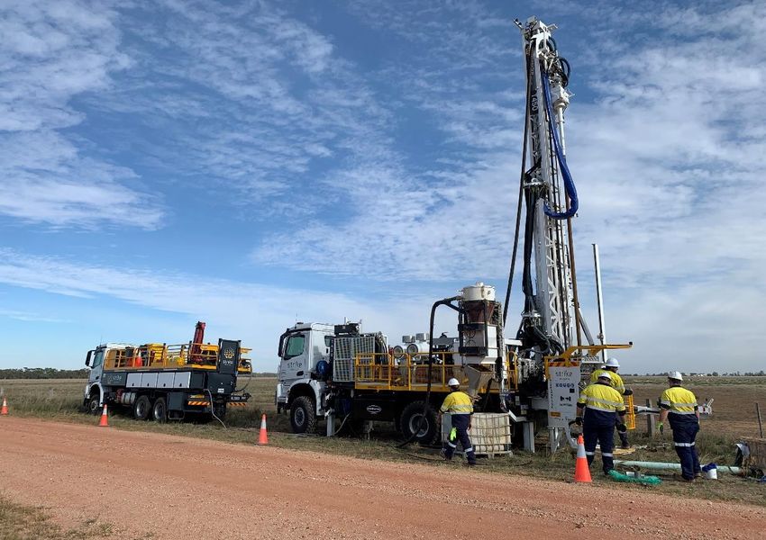
Table of Contents

   1.   Company Mission Statement………………………………………………………………………………..3
   2.   Project Background…………………………………………………………………………………………..4
   3.   Project Tenure………………………………………………………………………………………………...5
   4.   Exploration Activities………………………………………………………………………………………….6
   5.   Prior Stakeholder Engagement.……………………………………………………………………………..7
   6.   Communication……………….……………………………………………………………………………….7
   7.   Contact Us……………….…………………………………………………………………………………….8

        Figure 1. Chalice Mining’ drilling activity in progress at the Pyramid Hill Gold Project

                                      Community Fact Sheet | Chalice Mining Ltd | July 2021 | 2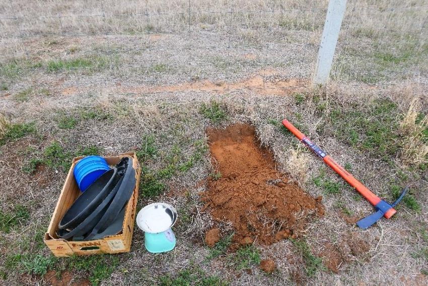
1. Company Mission Statement

Chalice Mining Limited (“Chalice” or “the Company”) aims to uphold the highest corporate, social and
environmental standards and recognises the importance of building respectful and inclusive relationships with
our Victorian stakeholders, communities and governing organisations.

Chalice is committed to open and transparent communication with the community in which it operates. The
Company aims to actively manage the impact of our activities through the continued consideration and
response to the interests and concerns of the local community.

We will respect the rights of all landowners and seek to minimise any potential disturbance associated with
our activities as much as possible through the following commitments:

          •   Provide key information on our exploration activities to local stakeholders.
          •   Consideration of any social, environmental and economic effects of Chalice’s
              activities at the local stakeholder level.

          •   Seek to understand stakeholder values, interests and concerns and address these
              in a timely manner.
          •   Ensure our employees and contractors are aware of their obligations with respect
              to the local community and environment.
          •   Contribute to the community through local employment opportunities and utilise
              local contractors and suppliers where possible.
          •   Communicate effectively through various means, including (in order of preference),
                    o   one-on-one meetings
                    o   telephone conversations
                    o   letter drops
                    o   email communications
                    o   newsletter communications
                    o   local and regional media placements
                    o   posting on our Company website

This statement is complementary to the regulatory requirements and established procedures
governed by the Victorian Code of Practice for Mineral Exploration.

                                     Community Fact Sheet | Chalice Mining Ltd | July 2021 | 3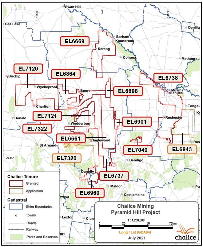
2. Project Background

The Pyramid Hill Gold Project comprises a combined granted land-holding of ~4831km2 with an additional
~1806km2 of ground currently in application (Figure 2). The distribution of exploration tenure (both granted
and in application) falls within the jurisdictions of the Loddon, Gannawarra, Campaspe, Northern Grampians,
Mt Alexander, Buloke, Greater Bendigo, Moorabool, Greater Geelong and Golden Plains local shires.

The majority of these licences are situated over privately-held farmland. Land use is predominantly for cereal
and hay crops as well as livestock (mainly sheep). All areas of tenure are readily accessible via a well-
connected network of roads and highways. This is useful for the purposes of exploration access,
supply/freighting routes, regional sampling, as well as access to emergency facilities such as hospitals, police
and fire departments.

The City of Bendigo serves as a central hub to the Pyramid Hill project tenure. Numerous smaller towns are
located within and/or proximal to each of the Exploration Licences. These towns may serve as convenient
locations to hold community forums as well as locations to accommodate field crews.

                        Figure 2. Plan map of Chalice Mining' exploration tenure

                                     Community Fact Sheet | Chalice Mining Ltd | July 2021 | 4
3. Project Tenure

Chalice is currently exploring for gold within its granted Exploration Licences located in the northern Bendigo
Zone, collectively referred to as the Pyramid Hill Gold Project.

The 100%-owned Project covers a number of highly prospective tenements across the northern Bendigo,
Stawell and Melbourne Zones of Victoria. Table 1 below outlines Chalice’s current tenure status.

Table 1. Chalice Mining Victorian exploration tenure summary

      Exploration               Status                                Area                 Shire
      Licence
      EL006661                  Granted                               711 km2              Loddon
      EL006737                  Granted                               781 km2              Loddon
      EL006738                  Granted                               905 km2              Campaspe
      EL006669                  Granted                               683 km2              Gannawarra &
                                                                                           Loddon
      EL006805                  Granted                               694 km2              Northern
                                                                                           Grampians &
                                                                                           Buloke
      EL006898                  Granted                               85km2                Loddon
      EL006901                  Granted                               55km2                Loddon
      EL006864                  Granted                               577km2               Loddon & Buloke
      EL006960                  Granted                               171km2               Mount Alexander
      EL007040                  Granted                               53km2                Greater Bendigo
      EL007020                  Granted                               834km2               Buloke
      EL007021                  Granted                               492km2               Loddon
      EL006943                  Application                           470km2               Campaspe
      EL007320                  Application                           434 km2              Loddon
      EL007200                  Application                           872 km2              Moorabool,
                                                                                           Greater Geelong
                                                                                           & Golden Plains

                                     Community Fact Sheet | Chalice Mining Ltd | July 2021 | 5
4. Exploration Activities
Exploration activities have progressed from initial desktop reviews to the commencement of field based
activities including drilling across selected areas of granted Exploration Licences. Field activities have largely
taken place in roadside reserves managed by Loddon and Campaspe shires where the Company has
obtained the required permits prior to undertaking any works and on private freehold land where the company
has entered into land access agreements with the owners.
The typical range of exploration field activities includes soil sampling, ground geophysical surveys (gravity,
magnetics, passive seismic) and drilling which are described in more detail below.
Soil Sampling
Soil sampling is an effective low impact reconnaissance technique which involves the collection of 1-2kg of
material from a small hand-dug hole 20-40cm below surface. Samples are collected by Chalice employees
from undisturbed locations along roadside reserves on widely spaced lines 1.6-2.3km apart with samples at
0.5km to 0.1km spacing. The material is sieved on site with various fractions collected for assay of gold and
pathfinder elements and the small holes are backfilled once sampling is complete.
Chalice has undertaken this technique across large areas of the tenement holdings to determine if
anomalous gold is present near surface which may be an indication of gold mineralisation at depth. The
technique has minimal disturbance to both the environment and to local residents (see Figure 3).
Figure 3. Soil sampling in roadside reserves.
The sample hole is backfilled at the completion of sampling.
Ground Geophysics
Ground geophysical techniques (magnetics, gravity, seismic etc) are widely used in exploration to assist with
target definition undercover and the advantage of these techniques is that these are essentially non-
disturbance activities. Field equipment is typically hand held and measurements are taken along selected
grid lines and roadside verges provide ideal access for hand-held field survey equipment to facilitate a broader
understanding on the propsectivity of the Project.
Drill Sampling
The Company has commenced reconnaissance drilling with Aircore (AC) and diamond drill rigs to test targets
that have been defined from a combination of soil geochemistry and ground geophysics. Drilling involves the
use of a dedicated drill rig to drill small diameter drill holes (up to 15cm diameter) to collect samples from
underlying rock sequences.
Please refer to our ‘Drilling Activity Information Sheet’ on our Company website for further information.
Community Fact Sheet | Chalice Mining Ltd | July 2021 | 65. Prior Stakeholder Engagement
Engagement with interested stakeholders has taken place during the company’s initial soil sampling program
along the public roadside verges. This was an ideal time for the company to introduce itself to local farmers
and explain its exploration program and licence holding in the area.
Chalice maintains a detailed Community Engagement Register providing a snapshot summary of prior
engagement activities.
6. C o m m u n i c a t i o n
Identifying stakeholders
Stakeholders will be identified by the following methods:
• Querying GIS spatial datasets to obtain address and/or contact information for plots of land that
coincide with a region of proposed work. Stakeholders will then be contacted by phone, by email or in
person to discuss the program of work and terms for land access.
• Stakeholders are welcome to approach any Chalice field personnel conducting sampling along public
roads. Field personnel will be equipped with documentation regarding the company’s exploration
activities and policies.
• A factsheet containing information relating to current exploration activities as well as company contact
information will be sent to the relevant local shire. Any stakeholders looking for information regarding
field activities or seeking to contact the company will be able to collect this document by contacting the
shire.
Communication with stakeholders
All communication with stakeholders will be in person as much as possible. Every effort will be made to
meet with the stakeholder at their estate or an appropriate location proximal to the area of proposed work.
There may be occasions where no company personnel are active in Victoria. In these cases Chalice
welcomes any enquiries via email or phone.
Responding to community concerns
Initial consultation with stakeholders will provide an opportunity to gauge community attitudes and
expectation.
All community feedback will be carefully considered when deciding how to proceed with exploration
programs and all reasonable measures will be made to ensure a satisfactory solution is achieved for all
parties.
Please refer to our ‘Community Feedback Information Sheet’ on our Company website for further
information.
Community Engagement Plan | Chalice Mining Ltd | July 2021 | 77. Contact us
Chalice Mining Limited
Level 2, 1292 Hay Street, West Perth, Western Australia 6005
GPO Box 2890, Perth, Western Australia 6001
T: +61 08 9322 3960
F: +61 08 9322 5800
E: info@chalicemining.com
W: www.chalicemining.com
Twitter: https://twitter.com/chalicemining
LinkedIn: https://www.linkedin.com/company/chalice-mining
Community Fact Sheet | Chalice Mining Ltd | July 2021 | 8You can also read