THAMES WATER MAINS REPLACEMENT BOURTON-ON-THE-WATER GLOUCESTERSHIRE ARCHAEOLOGICAL WATCHING BRIEF
←
→
Page content transcription
If your browser does not render page correctly, please read the page content below
THAMES WATER MAINS
       REPLACEMENT
   BOURTON-ON-THE-WATER
     GLOUCESTERSHIRE

ARCHAEOLOGICAL WATCHING BRIEF

              For

          OPTIMISE

          on behalf of

   THAMES WATER UTILITIES

       CA PROJECT: 3198
       CA REPORT: 10173

         OCTOBER 2010
THAMES WATER MAINS REPLACEMENT
                 BOURTON-ON-THE-WATER
                    GLOUCESTERSHIRE

                       ARCHAEOLOGICAL WATCHING BRIEF

                                            CA PROJECT: 3198
                                            CA REPORT: 10173

              prepared by          Jonathan Hart, Publications Officer and Jamie Wright, Project Officer

              date                                          24 October 2010

              checked by                             Cliff Bateman, Project Manager

              date                                          25 0ctober 2010

              approved by                             Simon Cox, Head of Fieldwork

              signed

              date                                          26 October 2010

              issue                                                 01

This report is confidential to the client. Cotswold Archaeology accepts no responsibility or liability to any third
     party to whom this report, or any part of it, is made known. Any such party relies upon this report entirely
           at their own risk. No part of this report may be reproduced by any means without permission.

                                           © Cotswold Archaeology
             Building 11, Kemble Enterprise Park, Kemble, Cirencester, Gloucestershire, GL7 6BQ
 Tel. 01285 771022                 Fax. 01285 771033            E-mail: enquiries@cotswoldarch.org.uk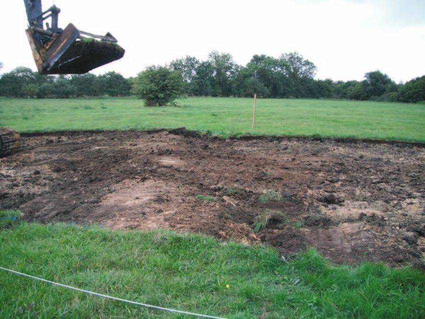
© Cotswold Archaeology Thames Water Mains Replacement, Bourton-on-the-Water, Gloucestershire: Archaeological Watching Brief
CONTENTS
SUMMARY........................................................................................................................ 2
1. INTRODUCTION ................................................................................................. 3
2. RESULTS (FIGS 2–5).......................................................................................... 4
3. DISCUSSION....................................................................................................... 5
4. CA PROJECT TEAM ........................................................................................... 6
5. REFERENCES .................................................................................................... 6
APPENDIX A: CONTEXT DESCRIPTIONS ..................................................................... 7
APPENDIX B: THE FINDS ............................................................................................... 8
APPENDIX C: OASIS REPORT FORM............................................................................ 8
LIST OF ILLUSTRATIONS
Fig. 1 Site location plan (1:25,000)
Fig. 2 The site, showing location of groundworks (1:1250)
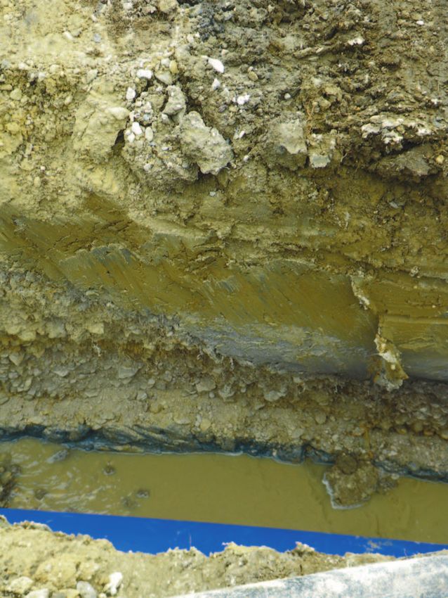
Fig. 3 Photograph, north facing section of pipe trench
Fig. 4 Photograph, trenching towards probable palaeochannel 016
Fig. 5 Photograph, bank 012: looking south
1
© Cotswold Archaeology   Thames Water Mains Replacement, Bourton-on-the-Water, Gloucestershire: Archaeological Watching Brief

SUMMARY

Project Name:             Thames Water Mains Replacement
Location:                 Bourton-on-the-Water, Gloucestershire
NGR:                      SP 1761 2164 to SP 1802 2153
Type:                     Watching Brief
Date:                     9 August to 13 September 2010
Location of Archive:      To be deposited with Corinium Museum
Site Code:                TBW 10

An archaeological watching brief was undertaken by Cotswold Archaeology during
groundworks along the Thames Water Mains Replacement, Bourton-on-the-Water,
Gloucestershire.

Two probable Holocene palaeochannels were identified cutting into the gravel terrace of the
River Windrush. Deposits of Holocene alluvium were also present and were sealed by a low
gravel bank which was visible as an earthwork either side of the pipeline. Although it
remained undated, the bank was clearly cut by the existing field boundaries.

                                                                                                                            2
© Cotswold Archaeology Thames Water Mains Replacement, Bourton-on-the-Water, Gloucestershire: Archaeological Watching Brief
1. INTRODUCTION
1.1 In August and September 2010 Cotswold Archaeology (CA) carried out an
archaeological watching brief for Optimise, on behalf of Thames Water Utilities,
along the Thames Water Mains Replacement, Salmonsbury Fields, Bourton-on-the-
Water, Gloucestershire (NGR: SP 1761 2164 to SP 1802 2153; Fig. 1). The work
comprised Permitted Development but was governed by Thames Water’s
responsibilities under the Code of Practice on Conservation, Access and Recreation
(LHA 2010). The objective of the watching brief was to record all archaeological
remains exposed during the development.
1.2 The watching brief was carried out in accordance with a request for archaeological
recording by Charles Parry, Senior Archaeological Officer, Gloucestershire County
Council (GCC), and with a Brief for archaeological recording issued by Lang Hall
Archaeology (LHA) for Optimise, on behalf of Thames Water Utilities (LHA 2010).
The methodology of the work was detailed in a subsequent Written Scheme of
Investigation (WSI) produced by CA (2010) and approved by Optimise acting on the
advice of LHA. The fieldwork also followed the Standard and Guidance for an
Archaeological Watching Brief issued by the Institute for Archaeologists (2008), the
Statement of Standards and Practices Appropriate for Archaeological Fieldwork in
Gloucestershire issued by Gloucestershire County Council Archaeology Section
(1995), the Management of Archaeological Projects (English Heritage 1991) and the
Management of Research Projects in the Historic Environment (MORPHE) (English
Heritage 2006).
The site
1.3 The pipeline route measures c. 400m in length and traverses meadows to the east
of Bourton-on-the-Water within the floodplain of the Rivers Dikler and Eye, both
tributaries of the River Windrush (Figs 1 and 2). It lies at approximately 120m AOD
and is generally level ground. The majority of the site forms part of the Salmonsbury
Meadows, a Site of Special Scientific Interest designated because of its species-rich
unimproved meadows (GWT 2010).
1.4 The underlying solid geology of the area is mapped as Mudstone of the Jurassic
Charmouth Mudstone Formation (BGS 2010). Quaternary deposits of the Sherborne
Member (limestone gravel forming a terrace of the River Windrush) are mapped to
3© Cotswold Archaeology Thames Water Mains Replacement, Bourton-on-the-Water, Gloucestershire: Archaeological Watching Brief
the east of the River Dikler and west of the River Eye, while Holocene Alluvium
deposits (Clay, Silt, Sand and Gravel) are mapped between the rivers. Blue-grey
clay overlain by calcareous gravel was exposed during the watching brief.
Archaeological background
1.5 The Scheduled Monument of Salmonsbury Camp, an Iron Age hillfort with Neolithic
origins, is located 800m to the south-west of the site (Lang 2008). A geophysical
survey of the pipeline route undertaken by Archaeological Surveys Ltd indicated the
presence of features of unknown provenance, although the existing pipe had caused
considerable magnetic disturbance to the geophysical plot (AS 2010).
Methodology
1.6 The fieldwork followed the methodology set out within the WSI (CA 2010). An
archaeologist was present during intrusive groundworks comprising deturfing
throughout the 13m wide fenced corridor and the subsequent excavation of a 0.6m–
1m wide pipe trench as well as launch and reception pits for boring under the River
Eye (Fig. 2).
1.7 Where archaeological deposits were encountered written, graphic and photographic
records were compiled in accordance with CA Technical Manual 1: Fieldwork
Recording Manual (2007).
1.8 The archive from the watching brief is currently held by CA at their offices in Kemble
and will be deposited with Corinium Museum, Cirencester. A summary of information
from this project, set out within Appendix C, will be entered onto the OASIS online
database of archaeological projects in Britain.
2. RESULTS (FIGS 2–5)
2.1 The earliest encountered deposit was the geological substrate, comprising compact
blue-grey clay 020/206, exposed at the bases of the pipe trench and the launch pit
(Fig. 3).. It was overlain by several layers of white calcareous gravel with occasional
bands of pale grey clay (layers 003, 017–019, 204 and 205), together measuring up
to 0.4m thickness. The uppermost of these deposits had been cut by undated tree-
throw pit 004 and by two probable palaeochannels, each approximately 50m–65m
wide. Unfortunately, the extremely wet ground conditions prevented these deposits
4© Cotswold Archaeology Thames Water Mains Replacement, Bourton-on-the-Water, Gloucestershire: Archaeological Watching Brief
from being recorded in section, so the morphology and depths of the probable
paleochannels remained undetermined (Fig. 4). Neither the tree-throw pit nor the
possible palaeochannels were recorded during the preceding geophysical survey.
2.2 The tree-throw pit and probable palaeochannels were sealed by several alluvial clay
deposits (006, 009, 014, 015 and 203), which together were up to 0.4m thick. Of
these, layer 009 contained a 0.05m thick deposit of tree bark fragments, 011.
2.3 Gravel bank 012 was built onto alluvial clay layer 009 (Fig. 5). This bank was 1.3m
wide and 0.17m high and was visible as an earthwork within the fields either side of
the pipeline, where it was clearly cut by the existing field boundaries. The bank was
not recorded during the geophysical survey.
2.4 The foregoing deposits were sealed by subsoil 010/202 which was itself covered by
topsoil (001, 002, 013 and 201). A layer of fragmented tree bark, 008, was present
within the topsoil. The latest encountered deposits were the cut and fills of the
existing water mains (cuts 207, 209 and 211; fills 208, 210 and 212).
The finds
2.5 The recovered finds assemblage comprises unstratified material collected during de-
turfing. This material includes Roman pottery, comprising single sherds of Central
Gaulish Samian ware, Central Gaulish black-slipped ware, and a sandy greyware.
The remaining material is modern and includes an iron nail and one sherd of refined
whiteware with transfer print-decoration. As the material is unstratified, it will be
discarded.
3. DISCUSSION
3.1 None of the discrete anomalies recorded during the geophysical survey were
identified during the watching brief. The blue-grey clay exposed at the base of the
pipe trench and launch pit is probably part of the Jurassic Charmouth Mudstone
Formation (BGS 2010) with the overlying gravels forming part of the Quaternary
Sherborne Member gravel terrace of the River Windrush (ibid.). The two probable
paleochannels and the overlying alluvial clays probably relate to the Holocene
Alluvium deposits mapped between the Rivers Dikler and Eye (ibid.).
5© Cotswold Archaeology Thames Water Mains Replacement, Bourton-on-the-Water, Gloucestershire: Archaeological Watching Brief
3.2 Gravel bank 012 overlying the alluvial clay remained undated but formed part of an
earthwork extending beyond the pipe corridor where it was cut by the existing field
boundaries. The bank is visible on recent satellite images extending on a very
straight alignment for over 200m. Its function and date remain undetermined,
although the possibility that it was part of a former flood defence for the River Eye,
or was associated with former water meadows, should not be overlooked.
4. CA PROJECT TEAM
Fieldwork was undertaken by Jonathan Hart and Jamie Wright, who co-authored this
report. The illustrations were prepared by Lorna Gray. The archive has been
compiled by Jonathan Hart and prepared for deposition by James Johnson. The
project was managed for CA by Cliff Bateman.
5. REFERENCES
AS (Archaeological Survey) 2010 Salmonsbury Meadow, Water Main Replacement Work,
Bourton-on-the-Water, Gloucestershire. Magnetomter Survey Report. Typescript
report 328
BGS (British Geological Survey) http://www.bgs.ac.uk/geology
viewer_google/googleviewer.html accessed 25 August 2010
CA (Cotswold Archaeology) 2010 Thames Water Mains Replacement, Bourton on the
Water, Gloucestershire: Written Scheme of Investigation for an Archaeological
Watching Brief
Lang, A. 2008 ‘Excavations at Bourton Primary School and the Cotswold School, Bourton-
on-the-Water’, Glevensis 41, 5–11
LHA (Lang Hall Archaeology) 2010 A brief for monitoring of water main replacement in
Salmonsbury Fields, Bourton-on-the-Water, Gloucestershire
GWT (Gloucestershire Wildlife Trust)
http://www.gloucestershirewildlifetrust.co.uk/Gwt/Gwt.Nsf/WEBARTICLE?OpenForm
&id=7C5F41BEB0A560B08025742F0039F5F8 accessed 27 October 2010
6© Cotswold Archaeology Thames Water Mains Replacement, Bourton-on-the-Water, Gloucestershire: Archaeological Watching Brief
APPENDIX A: CONTEXT DESCRIPTIONS
No. Type Description Length Width Depth Spot-
(m) (m) (m) date
001 Layer Turf 0.1
002 Layer Topsoil 0.1
003 Layer Natural: calcareous sand and gravel 0.2
004 Cut Tree-throw pit 3.8 0.4 -
005 Layer Grey clay fill of 004 3.8 0.4 -
006 Layer Alluvium : pale grey clay 0.07
007 Layer Friable silt layer sealed by 006 -
008 Layer Intermittent spread of possible tree bark/reeds within 0.05
002
009 Layer Alluvium: grey clay 0.09
010 Layer Subsoil below layer 002 0.3
011 Layer Layer of tree bark within alluvium 009 0.05
012 Layer Field boundary: bank of gravel overlying alluvium 009 >13 1.3 0.17
013 Layer Topsoil between Rivers Dikler and Eye: grey loam 0.12
014 Layer Natural between Rivers Dikler and Eye: grey clay 0.2
015 Layer Natural seen in launch pit: grey clay 0.3
016 Layer Natural seen in launch pit: layer below layer 015 0.03
017 Layer Natural seen in launch pit: pale grey gravel below -
layer 016
018 Layer Natural seen in launch pit: grey gravel below layer 0.14
017
019 Layer Natural seen in launch pit: yellow-brown gravel below 0.3
layer 018
020 Layer Natural seen in launch pit: compact blue-grey clay -
below layer 019
201 Layer Topsoil 0.2
202 Layer Subsoil: mid orange-brown silty clay 0.1
203 Layer Alluvium below 201: green-grey clay 0.4
204 Layer Natural: white calcareous limestone gravel below 203 0.4
205 Layer Natural: grey silty sand with calcareous limestone >1.0
gravel lenses below 204. Not excavated to full depth
206 Layer Natural: compact blue-grey clay below 204 >0.4
207 Cut Cut for existing pipe trench 5m c. 1.6m
208 Fill Existing pipe trench 207: fill and pipe 5m c. 1.6m
209 Cut Cut for existing pipe trench 3m c. 1.6m
210 Fill Existing pipe trench 209: fill and pipe 3m c. 1.6m
211 Cut Cut for existing pipe trench 1m c. 1.6m
212 Fill Existing pipe trench 211: fill and pipe 1m c. 1.6m
7© Cotswold Archaeology Thames Water Mains Replacement, Bourton-on-the-Water, Gloucestershire: Archaeological Watching Brief
APPENDIX B: THE FINDS
Table 1: finds quantification
Context Description Ct. Wt. (g) Date
u/s Roman pottery: CG Samian ware; CG black slipped ware, 3 16 -
greyware 1 2
Modern pottery: refined whiteware 1 36
Modern nail
APPENDIX C: OASIS REPORT FORM
PROJECT DETAILS
Project Name Thames Water Mains replacement, Bourton-on-the-
Water, Gloucestershire: Archaeological Watching
Brief
Short description An archaeological watching brief was undertaken by
Cotswold Archaeology during groundworks along
the Thames Water Mains Replacement, Bourton-on-
the-Water, Gloucestershire.
Two probable Holocene palaeochannels were
identified cutting into the gravel terrace of the River
Windrush. Deposits of Holocene alluvium were also
present and were sealed by a low gravel bank which
was visible as an earthwork either side of the
pipeline. Although it remained undated, the bank
was clearly cut by the existing field boundaries and
is likely therefore to be of some antiquity, perhaps
being medieval or earlier in date.
Project dates 9 August–13 September 2010
Project type Archaeological Watching Brief
Previous work None
Future work Unknown
PROJECT LOCATION
Site Location Thames Water Mains replacement, Bourton-on-the-
Water, Gloucestershire
Study area n/a
Site co-ordinates SP 1761 2164 to SP 1802 2153
PROJECT CREATORS
Name of organisation Cotswold Archaeology
Project Brief originator Lang Hall Archaeology
Project Design (WSI) originator Cotswold Archaeology
Project Manager Cliff Bateman
Project Supervisor Jonathan Hart and Jamie Wright
PROJECT ARCHIVES Intended final location of Content
archive
Physical n/a n/a
Paper Corinium Museum Context records,
drawings
Digital Corinium Museum reports
BIBLIOGRAPHY
CA (Cotswold Archaeology) 2010 Thames Water Mains replacement, Bourton-on-the-Water, Gloucestershire:
Archaeological Watching Brief CA typescript report No. 10173
8Reproduced from the 1998 Ordnance Survey Explorer map with the permission
of Ordnance Survey on behalf of The Controller of Her Majesty's Stationery Office
c Crown copyright Cotswold Archaeological Trust 100002109
N
site
0 2.5km
COTSWOLD ARCHAEOLOGY
PROJECT TITLE
Thames Water mains replacement
Bourton-on-the-water, Gloucestershire
FIGURE TITLE
Gloucestershire
Site location plan
DRAWN BY SCALE PROJECT NO. FIGURE NO.
LG 1:25,000@A4 3198 13
alluvial clays
203
gravels 205
gravels 204
natural clays 206
COTSWOLD ARCHAEOLOGY
3 North facing section of pipe trench PROJECT TITLE
Thames Water mains replacement
Bourton-on-the-water, Gloucestershire
FIGURE TITLE
Photograph
DRAWN BY SCALE PROJECT NO. FIGURE NO.
LG n/a 3198 34
5
bank
012
COTSWOLD ARCHAEOLOGY
4 Trenching towards probable palaeochannel 016 PROJECT TITLE
Thames Water mains replacement
Bourton-on-the-water, Gloucestershire
5 Bank 012, looking south FIGURE TITLE
Photograph
DRAWN BY SCALE PROJECT NO. FIGURE NO.
LG n/a 3198 4&5You can also read