CORS ZWD Augmented PPP for Bridge Displacement Monitoring - FIG
←
→
Page content transcription
If your browser does not render page correctly, please read the page content below
CORS ZWD Augmented PPP for Bridge Displacement Monitoring

        Xu TANG, Huib de LIGT, China, Gethin Wyn ROBERTS, Faroe Islands, Craig
                             Matthew HANCOCK, China
   Keywords: troposphere augmentation; displacement monitoring; PPP

   SUMMARY
   PPP is an optimal method for bridge deflection monitoring, particular in the scenario that
   Double Difference (DD) method is not available due to the reference station failure. More than
   20 minutes has to be taken for a reasonable precision when PPP is used for the bridge
   monitoring. Instead of estimated the tropospheric delays with position in general PPP method,
   we take the tropospheric delays derived for the local CORS as a tropospheric correction on the
   observations. GNSS data gathered on the Severn bridge, UK is used for assessing the
   tropospheric correction PPP performance. The studies implied that CORS tropospheric
   correction augmented PPP can effectively shorten the convergence period. Additionally, the
   PPP precision is also improved by using the local CORS derived troposphere correction.

CORS ZWDAugmented PPP for Bridge Deflection Monitoring (10596)
Xu Tang, Huib de Ligt (China, PR), Gethin Roberts (Faroe Islands) and Craig Matthew Hancock (China, PR)
FIG Working Week 2020
Smart surveyors for land and water management
Amsterdam, the Netherlands, 10–14 May 2020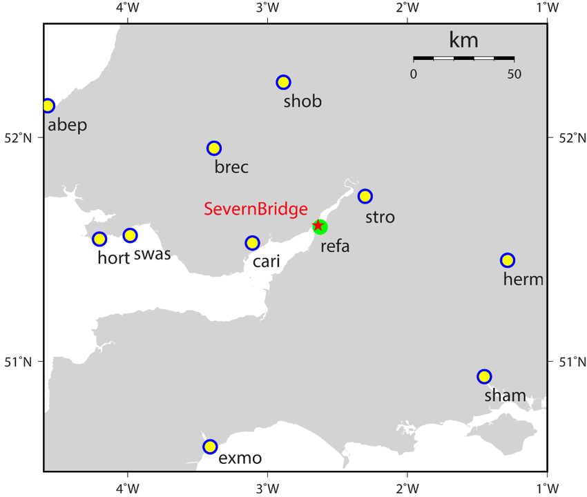
CORS ZWD Augmented PPP for Bridge Displacement Monitoring

        Xu TANG, Huib de LIGT, China, Gethin Wyn ROBERTS, Faroe Islands, Craig
                             Matthew HANCOCK, China

        1. INTRODUCTION
   PPP has been investigated for the bridge monitoring in the past few years. PPP is a viable option
   for the bridge monitoring in the scenario that DD method is failure. However, PPP displacement
   monitoring precision is not as good as that of DD. The long time requirement of PPP
   convergence for a reasonable monitoring precision also limits the PPP practicality in many
   potential applications. Many previous studies has been investigate the PPP precision
   improvement, short time converging. Wilgan et al. (2017) assessed the contribution of PPP
   positioning precision and convergence time using varieties of mapping functions and Zenith
   Total Delays (ZTDs), which are calculated by the Weather Research Forecasting (WRF) model
   and local GNSS permanent network stations, respectively. Yao et al. (2018) compared the ZTDs
   from Global Geodetic Observing System (GGOS) with the ZTD products from IGS stations.
   The spatial and temporal resolution of GGOS’s ZTD, with 2.5◦ × 2◦ grids and 6-hour interval
   resolutions, improves the real time PPP convenience and positioning precision on the up-
   component particularly. An external Numerical Weather Model (NWM) WRF, with 9 km × 9
   km spatial and 6-hour temporal resolutions, was applied for improving PPP position parameters
   precision in an experiment that hot air balloon flight from earth surface to the 2 Km altitude
   (Vaclavovic et al. 2017). Convergence time can be shortened by applying the WRF ZTD
   constrain in the PPP. Positioning results are also credible while the geometry change suddenly,
   due to satellite flies in or out of view. These studies confirm that PPP can be augmented by
   using the external NWM (Alves et al. 2016; Yao et al. 2017). Viable alternative to the external
   NWM for augmenting the PPP, a global distributed GNSS stations or region CORS are applied
   to improving the PPP performance(Li et al. 2013; Zhang et al. 2011). Oliveira et al. (2017)
   modeled the troposphere by the local CORS and investigated the dense and sparse network
   contributions to the PPP augmentation. The previous studies implied that there is no evident
   difference between PPP positioning time series augmented by tropospheric corrections,
   respectively derived by dense and sparse networks.
   This paper investigated the ZTD augmentation for the PPP bridge displacement monitoring. the
   ZTD over the bridge has been modeled by the selected stations from the local CORS. Bridge
   data are applied for assessing the performance of the ZTD augmented PPP. ZTD at the bridge
   surveying point is first interpolated from the CORS modeled ZTD, then applied as the PPP
   correction for the bridge displacement monitoring. in the results’ section, DD bridge
   displacement time series are used as the truth, compared against the PPP time series.

      2. EXPERIMENT DESCRIPTION
   Blue cycles with yellow dots in auxiliary figure 1 represent the locations of 10 selected UK
   CORS permanent stations, distributed around the Severn Bridge. The red pentagram represents
   where the bridge is. Green dot shows the location of reference station, which is 1.416 km far

CORS ZWDAugmented PPP for Bridge Deflection Monitoring (10596)
Xu Tang, Huib de Ligt (China, PR), Gethin Roberts (Faroe Islands) and Craig Matthew Hancock (China, PR)
FIG Working Week 2020
Smart surveyors for land and water management
Amsterdam, the Netherlands, 10–14 May 2020
away from the farthest surveying point A at bridge midspan (figure 1). All receiver’s cut off
   angle at each CORS station was set as 5 degree. The sampling rate of receiver is 1 Hz.

      Fig. 1 10 selected UK CORS stations surrounding of bridge (blue cycles with solid yellow dots),
                                location of Severn Bridge (pentagram)

   There are 3 Leica 1200 dual frequency GPS receivers mounted on the suspension cable. The
   raw GPS data was gathered at the rate of 20 Hz. The reference station is equipped with the
   Leica Viva receiver, which was configured to gathering data at the rate of 10 Hz. Cut off angle
   was set as 5 degree as well. Datasets between 8:00 to 09:30 11st March 2019 were processed
   in this study, with all 3 rover stations and reference station continually tracking satellites over
   one and half hour.

CORS ZWDAugmented PPP for Bridge Deflection Monitoring (10596)
Xu Tang, Huib de Ligt (China, PR), Gethin Roberts (Faroe Islands) and Craig Matthew Hancock (China, PR)
FIG Working Week 2020
Smart surveyors for land and water management
Amsterdam, the Netherlands, 10–14 May 2020
Fig. 2 The changing of wet path delay with GPS PRN 03 satellite elevation varying.
Figure 2 shows the zenith wet delay mapped on the “line-of-sight” between GPS PRN 03
satellite and antenna at UK CORS STRO station. The wet path delay is no more than 20 cm
while the satellite elevation is bigger than 30 degree, but increasing significantly with the
elevation decreasing from 30 to 5 degree. The maximum wet delay GPS PRN 03 can be up to
113 cm while the elevation is 5 degree. Better GPS constellation geometry can be obtained
while the satellites with low elevation employed for PPP data processing, Meanwhile, the
bigger noise will challenge the positioning precision. Time varying tropospheric parameters are
precisely modeled and employed for investigating the contribution to PPP applied in structure
deflection monitoring with different cut off angle configuration.
3. DATA PROCESS AND RESULTS
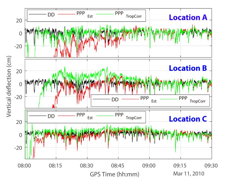
Figure 3 illustrates the DD deflection time series and the PPP without/with troposphere augment
time series at location A, B and C. The cut off angle is set as 05 degree in case of the worse
geometry reduce the general PPP positioning performance and precision. The top, middle and
bottom panels shows that the augmentation PPP has short convergence time, comparing that
general PPP, at locations A, B and C, respectively. There is no specific constant convergence
time at these three locations. The augment PPP takes approximate 5 minutes for achieving the
deflection monitoring precision requirement at location A, while the general PPP takes more
than half an hour. We can also see the convergence time improvement at locations B and C, but
is not so distinguished like that of Location A. The correct peaks in PPP time series are also
CORS ZWDAugmented PPP for Bridge Deflection Monitoring (10596)
Xu Tang, Huib de Ligt (China, PR), Gethin Roberts (Faroe Islands) and Craig Matthew Hancock (China, PR)
FIG Working Week 2020
Smart surveyors for land and water management
Amsterdam, the Netherlands, 10–14 May 2020extracted during the convergence time either with or without the troposphere correction at
location B. This reflects that the antenna oscillation is not the reason degrading the PPP
convergence time.
Fig. 3 PPP time series without/with the troposphere augmentation at Location A, B and C. The cut off
angle is 5 degree.
We also investigate the positioning precision improvement by employing the augmented PPP
in bridge deflection monitoring. So as to avoid the effecion of convergence time on analyzing
the PPP deflection monitoring precision, the time series at location A, B and C from 9:00 to
9:30 after one-hour convergence are chosen to calculate the root mean square error and
correlation coefficients. DD time series is treated as the truth deflection of bridge. Top 3 panels
of figure 4 show that bridge deflection time series’ errors at all 3 location individually
increasing while the cut off angle is set as 5, 10 and 15 degree, respectively. Green bars in figure
4 top 3 panels did not show the consistence of RMSEs and the individual cut off angles. This
proves that the the troposphere correction augmented PPP is not sensortive to positioning
precision, but the general PPP is. Bottom 3 panels of figure 4 show the correlation coefficients
between PPP and DD deflection time series. Augemented PPP has better than 0.8 correlation
coefficient at 5, 10 and 15 cut off angles. PPP correclation coefficient without the tropospheric
augmentation can only be up to 0.8 while the elevation is 15 degree. Performance of
unaugmented PPP is worse than augmented PPP in the term of either correlation coefficinet or
RMSE at 05 degree cut off angle, at which unaugmented PPP has best performance, comparing
with that of 10 and 15 degree cut off angle.
CORS ZWDAugmented PPP for Bridge Deflection Monitoring (10596)
Xu Tang, Huib de Ligt (China, PR), Gethin Roberts (Faroe Islands) and Craig Matthew Hancock (China, PR)
FIG Working Week 2020
Smart surveyors for land and water management
Amsterdam, the Netherlands, 10–14 May 2020The improment of position precision due to the gredient correction is not evident. The
maximum defferences of RMSE is 3.2 mm at location C when the elevation cut off angle is 15
degree. The relative bigger effection of gradient is on the signal fsrom the satellite elevation
below 15 degree. The RMSEs reduce by 2.4 mm and 0.3 mm, respectively, at location B and C
when the elevation cut off angle is 5 degree. The RMSE of ZWD correct PPP is even 1.6 mm
worse than that of ZWD+Grid correct PPP. The gradient has few milimeter positioning
precision effection on the tropospheric augmented PPP.
Fig. 4 Root mean square error and correlation coefficients of location A, B and C PPP time series at
05, 10 and 15 degree cut off angle.
4. CONCLUSION
PPP is an alternative method for the structure monitoring when DD is failed due to the reference
station is not available. Varieties of errors in PPP procedure have to be eliminated or reduced
for the high precision of positioning applied in the structure monitoring. ZTD consists ZHD
and ZWD can introduce meters delay on the signal between satellite and terminal receivers’
antenna. ZHD can be precise modeled, but the time varying ZWD dependents on the weather
situation around the antenna. This paper invests structure monitoring using PPP augmented by
the “given” ZWD, which is interpolated at the surveying point from CORS station. ZWD is
approximate 10 cm at the zenith direction, can introduce meters delay at the receiver-satellite
direction. PPP precision with the ZWD augmentation can be significantly improved,
particularly in the scenario that low elevation signal is blocked by obstacles. The gradient
effection brings sub-centimeter delay on the signal at the satellite with lower than 15-degree
CORS ZWDAugmented PPP for Bridge Deflection Monitoring (10596)
Xu Tang, Huib de Ligt (China, PR), Gethin Roberts (Faroe Islands) and Craig Matthew Hancock (China, PR)
FIG Working Week 2020
Smart surveyors for land and water management
Amsterdam, the Netherlands, 10–14 May 2020elevation, and only few millimeter effection on the positioning precision. Bridge experiment
illustrates that augmented PPP not only shorten the convergence time, but also improves
deflection monitoring precision of general PPP applied in structure monitoring.
Acknowledgement
The authors acknowledge the IGS for providing the high-rate GPS observations, satellite clock
and orbital products. This work is supported by the Young Scientist program of the Natural
Science Foundation of China (NSFC) with a project code 41704024, the Startup Foundation for
Introducing Talent of NUIST (project 2019r034), as well as the Ningbo science and technology
bureau commonweal program (project 20181JCGY020386).
REFERENCES
Alves DBM, Sapucci LF, Marques HA, de Souza EM, Gouveia TAF, Magario JA (2016) Using a
regional numerical weather prediction model for GNSS positioning over Brazil Gps Solutions
20:677-685 doi:10.1007/s10291-015-0477-x
Li X, Ge M, Douša J, Wickert J (2013) Real-time precise point positioning regional augmentation for
large GPS reference networks GPS Solutions 18:61-71 doi:10.1007/s10291-013-0310-3
Oliveira PS, Morel L, Fund F, Legros R, Monico JFG, Durand S, Durand F (2017) Modeling
tropospheric wet delays with dense and sparse network configurations for PPP-RTK Gps
Solutions 21:237-250 doi:10.1007/s10291-016-0518-0
Vaclavovic P, Dousa J, Elias M, Kostelecky J (2017) Using external tropospheric corrections to improve
GNSS positioning of hot-air balloon Gps Solutions 21:1479-1489 doi:10.1007/s10291-017-
0628-3
Wilgan K, Hadas T, Hordyniec P, Bosy J (2017) Real-time precise point positioning augmented with
high-resolution numerical weather prediction model Gps Solutions 21:1341-1353
doi:10.1007/s10291-017-0617-6
Yao YB, Peng WJ, Xu CQ, Cheng SY (2017) Enhancing real-time precise point positioning with zenith
troposphere delay products and the determination of corresponding tropospheric stochastic
models Geophysical Journal International 208:1217-1230 doi:10.1093/gji/ggw451
Yao YB, Xu XY, Xu CQ, Peng WJ, Wan YY (2018) GGOS tropospheric delay forecast product
performance evaluation and its application in real-time PPP J Atmos Sol-Terr Phy 175:1-17
doi:10.1016/j.jastp.2018.05.002
Zhang BC, Teunissen PJG, Odijk D (2011) A Novel Un-differenced PPP-RTK Concept J Navigation
64:S180-S191 doi:10.1017/S0373463311000361
CORS ZWDAugmented PPP for Bridge Deflection Monitoring (10596)
Xu Tang, Huib de Ligt (China, PR), Gethin Roberts (Faroe Islands) and Craig Matthew Hancock (China, PR)
FIG Working Week 2020
Smart surveyors for land and water management
Amsterdam, the Netherlands, 10–14 May 2020BIOGRAPHICAL NOTES Dr Xu Tang is an associate professor in Nanjing University of Information Science & Technology, Nanjing, China. His research interest covers various aspects of Engineering Surveying, Deformation monitoring, research into GNSS PPP for structure deflection detection, vapor remote sensing using GNSS etc. Mr. Huib Ligt is a teacher at the University of Nottingham in Ningbo China in all the practical aspects of engineering surveying and geodesy. He obtained his MSc degree in geodetic engineering from the Delft University of Technology in the Netherlands. After working at the University of Nottingham in the UK for five years as an experimental officer, Huib worked two years at Septentrio Satellite Navigation in Belgium as a test automation engineer. Dr Gethin Wyn Roberts is an Associate Professor at Fróðskaparsetur (University of the Faroe Islands). He has co-authored over 270 papers and co-supervised 25 Ph.D. students. He previously held posts at the University of Nottingham both in the UK and in China. He is a recipient of the Zhejiang Province 1000 Talent programme. He holds a 1st class honors degree BEng in Mining Engineering and a Ph.D. in Engineering Surveying and Geodesy both from the University of Nottingham, UK. Dr Craig Matthew Hancock is currently Head of Civil Engineering at the University of Nottingham Ningbo China campus. He obtained a degree in surveying and mapping science from Newcastle University (UK) and a Ph.D. in Space Geodesy also from Newcastle University (UK). His main research interests are GNSS Ionospheric error mitigation and Structural Monitoring. CORS ZWDAugmented PPP for Bridge Deflection Monitoring (10596) Xu Tang, Huib de Ligt (China, PR), Gethin Roberts (Faroe Islands) and Craig Matthew Hancock (China, PR) FIG Working Week 2020 Smart surveyors for land and water management Amsterdam, the Netherlands, 10–14 May 2020
CONTACTS

   Xu Tang
   School of Remote Sensing & Geomatics Engineering, Nanjing University of Information
   Science & Technology, 219 Ningliu Road, Nanjing 210044, Jiangsu, P. R. China
   Email: Xu.Tang@hotmail.com
   Web site: https://ycxy.nuist.edu.cn/2018/0323/c107a546/page.htm
   Huib de Ligt
   University of Nottingham Ningbo China, 199 Taikang East Road, Ningbo 315100, Zhejiang,
   P. R. China
   Email: Huib.deligt@nottingham.edu.cn

   Gethin Wyn Roberts
   Faculty of Science and Technology, University of the Faroe Islands, Tórshavn, Faroe Islands
   Email: GethinR@setur.fo
   Web site: https://www.setur.fo/en/the-university/staff/gethin-roberts/

   Craig Matthew Hancock
   University of Nottingham Ningbo China, 199 Taikang East Road, Ningbo 315100, Zhejiang,
   P. R. China
   Email: Craig.hancock@nottingham.edu.cn
   Web site: https://www.nottingham.edu.cn/en/science-engineering/staffprofile/craig-matthew-
   hancock.aspx

CORS ZWDAugmented PPP for Bridge Deflection Monitoring (10596)
Xu Tang, Huib de Ligt (China, PR), Gethin Roberts (Faroe Islands) and Craig Matthew Hancock (China, PR)
FIG Working Week 2020
Smart surveyors for land and water management
Amsterdam, the Netherlands, 10–14 May 2020
You can also read