2020 Work Plan for Long-term Monitoring of Protected Instream Flow Water Conductivity/Temperature/Depth Datalogging and Floodplain Transect ...
←
→
Page content transcription
If your browser does not render page correctly, please read the page content below
2020 Work Plan for Long-term Monitoring of
              Protected Instream Flow
(Water Conductivity/Temperature/Depth Datalogging and
           Floodplain Transect Monitoring)

                   Warner River – Warner, NH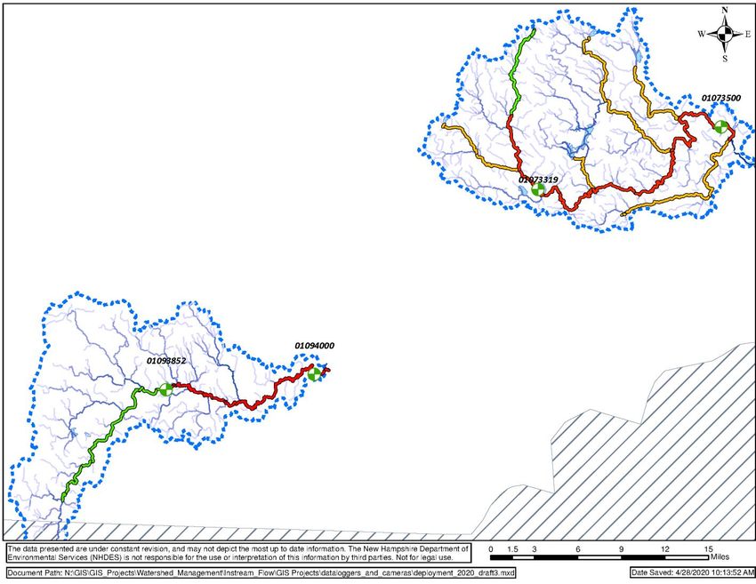
Updated: May 2020

                                                                     TABLE OF CONTENTS

Introduction ................................................................................................................................................................ 23
Long-Term Protected Instream Flow Monitoring Study Design ................................................................................... 3
   Daily Review of US Geological Survey Gaging Station Time-Series Instream Flow Data .......................................... 4
       Recreational Protected Instream Flow ................................................................................................................. 5
       Fish and Aquatic Life protected instream flow ................................................................................................... 56
   Water Quality/Quantity Monitoring ......................................................................................................................... 6
   Electrofishing ............................................................................................................................................................ 9
   Floodplain Transect Elevation and Habitat/Vegetation Surveys ............................................................................ 11
Protected Instream Flow Development Study Design ................................................................................................ 12
Sampling Tasks ............................................................................................................................................................ 12
   Datalogger Measurements ..................................................................................................................................... 12
   Electrofishing .......................................................................................................................................................... 13
   Floodplain Transect Survey ..................................................................................................................................... 13
Appendix A - Instream Flow Monitoring Protocols for Conductivity, Temperature, and Water Level Dataloggers
(2020) .......................................................................................................................................................................... 15
Appendix B - NHDES Protocols for Collection, Identification, and Enumeration of Freshwater Fishes (2018) ........... 16
Appendix C - NHDES Protocols for Stream Gradient and Floodplain Transect Survey (2020) .................................... 17
Appendix D - NHDES Protocols for Assessing Long-term Monitoring of Riparian Habitat (2020).............................. 18

Introduction
The New Hampshire Instream Flow Program is conducting long-term monitoring to assess the effectiveness of
instream flow protection and the Water Management Plans on meeting Water Quality Standards as demonstrated
by long-term trends in biological conditions. Results will influence whether the Water Management Plans are
meeting Water Quality Standards, or whether the Water Management Plans should be modified using adaptive
management. The Program envisions long-term monitoring applied to stations on each Designated River. The
Program has delineated segments of the Designated Rivers having similar character under its Target Fish
Community assessment. These segments are the basis of the long-term monitoring effort. This Work Plan
describes the tasks to be performed during the 2020 field season in support of these efforts.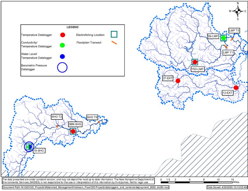
NHDES’ Watershed Management Bureau’s Instream Flow Program is conducting long-term monitoring on the
Lamprey and Souhegan Designated Rivers, where a pilot program demonstrated the viability and effectiveness of
the Program’s methods used to determine instream flow protection criteria and to manage water use and flow
conditions under statute RSA 483:9-c and Administrative Rules Env-Wq 1900. Long-term monitoring was listed as
a recommendation in the Pilot Program Final Report (R-WD-15-1, December 2015). Long-term monitoring
assesses ecosystem conditions to evaluate the effectiveness of the Water Management Plans on meeting
instream flow objectives and the Water Quality Standards, as demonstrated by long-term trends in biological
conditions. The components of the long-term monitoring program under the Water Management Plans are
subject to revision utilizing adaptive management concepts, if the proposed management activities do not prove
to be effective in meeting the Water Quality Standards. The assessment measures and methods of this program
are designed to measure changes in the protected entity communities resulting from the application of
management for maintaining protected instream flow.
In addition, Water Management Plan baseline data are being collected for the Ashuelot, Cold, Exeter, and Warner
Designated Rivers to assess conditions at possible, future long-term monitoring stations. Future long-term
monitoring stations are selected from historic electrofishing stations. Dataloggers, as available, are deployed
seasonally at a number of these stations. Staff will select only one or two of these stations to represent each
Target Fish Community segment. Final selection of the representative long-term monitoring station for each
segment will be based on observations and photos taken during deployment and retrieval, representativeness of
the positions of the stations within the Target Fish Community segment, and evaluation of the suitability for
electrofishing by the Biomonitoring Section staff.
Long-Term Protected Instream Flow Monitoring Study Design
The sampling design for the long-term monitoring is intended to provide data to be used to evaluate the success
of Water Management Plans by identifying changes in the following five parameters:
Evaluate the support of recreational use of Designated Rivers by determining the number of days per year
where the minimum flow required for recreational uses was achieved and comparing that value to the
baseline annual value, in order to identify possible trends;
Tracking the duration of periods when the minimum flow required for riparian vegetation and wildlife is
not met, via daily comparison of protected instream flow values (common, critical, and rare flows) for the
six annual bioperiods to the daily time-series instream flow data;
Targeted monitoring via in-situ dataloggers at established monitoring stations within the watershed of
each Designated River, to obtain water quality and quantity data within each watershed for comparison
with baseline values, in order to identify possible trends;
Regular documentation of the current Target Fish Communities at established monitoring sites via
electronic fishing, and comparison of the results with the baseline Target Fish Community, in order to
identify possible trends;
Regular documentation of the current riparian habitats and vegetation at established monitoring sites via
recurrent floodplain transect elevation and habitat/vegetation surveys, and comparison of the results
with the baseline surveys, in order to identify possible trends.Daily Review of US Geological Survey Gaging Station Time-Series Instream Flow Data
The Instream Flow Program Environmentalist will perform daily updates of the US Geological Survey stream gages
listed in Table 1. data that supports the following protected instream flow monitoring spreadsheets: Figure 1
depicts the location of the Lamprey and Souhegan River US Geological Survey gages.
Table 1: US Geological Survey Gaging Stations Used for Long-Term Instream Flow Monitoring
Station Name/US Geological Coordinates
protected instream flow Monitoring Spreadsheet
Survey ID (D.ddddd°)
LAMPREY RIVER NEAR
42.10279° N \\granite\shared\DES\DES-RESTRICTED\Repository\Watershed Instream
NEWMARKET, NH
70.95246° W Flow Tracking\Onestop\lamprey_protected instream flow_tracking.xlsx
01073500
SOUHEGAN RIVER (SITE WLR-1) \\granite\shared\DES\DES-RESTRICTED\Repository\Watershed Instream
42.84679° N
NEAR MILFORD, NH Flow Tracking\Onestop\Souhegan_upper_protected instream
-71.67868° W
01093852 flow_track.xlsx
SOUHEGAN RIVER AT \\granite\shared\DES\DES-RESTRICTED\Repository\Watershed Instream
42.85758° N
MERRIMACK, NH Flow Tracking\Onestop\Souhegan_lower_protected instream
-71.50617° W
01094000 flow_track.xlsx
D.ddddd° – Degrees to five decimal placesFigure 1: Proposed Gaging/Monitoring Stations on the Lamprey and Souhegan Rivers Recreational Protected Instream Flow The Lamprey River daily time-series data will be compared to the 275 cubic foot per second (cfs) or greater recreational boating flow rate set in the Lamprey River Water Management Plan. To track recurrence of the recreational flow rate, the upper Souhegan River daily time-series data will be checked against the 150 cfs or greater recreational boating criteria set in the Souhegan River Water Management Plan. The frequency and duration of these events will be followed to evaluate the maintenance of these flow conditions. For recreational boating, the number of days of occurrence of flows greater than 150 cfs annually in the upper Souhegan will be tracked by NHDES to ensure that the frequency trend of these events continues to match historical occurrence rates. The management strategy will consider this protected instream flow in the context of preserving the frequency of its occurrence. The instream flow for recreational boating use will continue to be met as it has been historically (that is, opportunistically). Management will not attempt to meet recreation needs on a continuous basis. Fish and Aquatic Life Protected Instream Flow To maintain and support fish and aquatic life in the Lamprey and Souhegan Rivers, the daily time-series data at each gage are compared to the protected instream flow criteria (common, critical, and rare flows) for the six
annual bioperiods. These values are set in Table 1 of the Lamprey River Water Management Plan and in Tables 1a
and 1b of the Souhegan River Water Management Plan. As noted in these Water Management Plans, a series of
actions, comprising short-term water use changes and dam releases, are proposed for the Designated Rivers in
the event that flow falls below critical or rare flow rates beyond their allowable or catastrophic durations

Water Quality/Quantity Monitoring
To track water quality and quality necessary to maintain and support fish and aquatic life in the Lamprey and
Souhegan Rivers, four (4) dataloggers will be used to measure conductivity, temperature, and/or water level at
established monitoring stations within the watershed of each Designated River. The dataloggers will be deployed
in the spring as soon as each river allows for safe wading access and recovered in the fall before the rivers and
their banks freeze and become unsafe. Refer to NHDES Standard Operating Procedure (SOP) Instream Flow
Monitoring Protocols for Conductivity, Temperature, and Water Level Dataloggers (Appendix A) for details
regarding deployment, recovery, and data management methods. Figure 2 depicts the datalogger/monitoring
stations in the Lamprey and Souhegan Designated River watersheds, respectively. Table 2 summarizes the
proposed datalogger deployment stations.

Table 2: Stations Proposed for Long-term Water Quality/Quantity Monitoring
                                                                                          Latitude       Longitude
     Station                    Datalogger Parameters                    Town
                                                                                         (D.ddddd°)     (D.ddddd°)
 Lamprey Designated River
    15D-LMP                         Temperature                          Epping         42.04023° N    -71.12974° W
     09-LMP                    Conductivity/Temperature                   Lee           43.11401° N    -71.00502° W
 Souhegan Designated River
                                Conductivity/Temperature
     19-SHG                     Temperature/Water Level                Greenville       42.77666° N    -71.80647° W
                                   Barometric Pressure
    08M-SHG                            Temperature                       Milford        42.83024° N    -71.62768° W
D.ddddd° – Degrees to five decimal places
Figure 2: Proposed Monitoring Stations on the Exeter, Lamprey, and Souhegan Rivers
The sampling design for the Ashuelot, Cold, Exeter, and Warner Designated Rivers is intended to collect baseline
water quality and quality data pertinent to water use, including impoundments/withdrawals, recreational use, the
maintenance and support of fish and aquatic life and riparian habitats for each Designated River, for inclusion in
the Water Management Plan to be developed for each Designated River:
Evaluate conductivity as an indicator of water quality at select stations where water quality issues are
suspected.
Evaluate water temperature as a parameter related to:
o The relationship between impoundments and river reaches in each Designated River; and
o The identification of Target Fish Communities within each Designated River.
Evaluate water depth as a surrogate for discharge at stations remote from current US Geological Survey
gages or at discontinued US Geological Survey gages, in order to improve the understanding of the
hydrology of each Designated River.
To eliminate critical gaps in the US Geological Survey gage network where water depth data can be used
as a surrogate. To document the retention and alteration of water passing through impoundments along the rivers.
To extend the record for prior sampling performed by other parties (i.e., US Geological Survey and NH Fish
and Game Department).
During the 2020 field season, twenty-one (21) monitoring stations will be utilized in the Ashuelot, Cold, Exeter,
and Warner Designated Rivers. The monitoring station locations are based on expanding the datasets available for
existing monitoring stations, as well as the locations of impoundments and possible electrofishing and floodplain
transect stations. Dataloggers will be used to measure conductivity, temperature, and/or water level at the
monitoring stations within the watershed of each Designated River. The dataloggers will be deployed in the spring
as soon as each river allows for safe wading access and recovered in the fall before the rivers and their banks
freeze and become unsafe. Refer to NHDES Instream Flow Monitoring Protocols for Conductivity, Temperature,
and Water Level Dataloggers (Appendix A) for details regarding deployment, recovery, and data management
methods. Table 3 summarizes the proposed datalogger deployment stations in the Ashuelot, Cold, Exeter, and
Warner Designated River watersheds. Figure 3 depicts the datalogger/monitoring stations in the Exeter
Designated River watershed. Figure 4 depicts the datalogger/monitoring stations in the Ashuelot, Cold, and
Warner Designated River watersheds.
Table 3: Stations Proposed for Long-term Monitoring Program Development Data Collection
Latitude Longitude
Station Datalogger Parameters Town
(D.ddddd°) (D.ddddd°)
Ashuelot River
05Q-ASH Temperature Winchester 42.77267° N -72.41009° W
USGS-01160350 Temperature Swanzey 42.87191° N -72.32809° W
16-ASH Temperature Swanzey 42.88620° N -72.28655° W
21-ASH* Temperature Surry 42.99216° N -72.30786° W
21F-ASH Temperature Surry 43.01906° N -72.31159° W
23C-ASH (formerly NHFG-535) Temperature Gilsum 43.05860° N -72.23970° W
ASHWASO*** Temperature/Water Level Washington 43.14932° N -72.15419° W
26-ASH* Temperature Washington 43.17108° N -72.15450° W
27-ASH Temperature Lempster 43.19894° N -72.13370° W
28-ASH Temperature Washington 43.22555° N -72.11885° W
28-ASH** Barometric Pressure Washington 43.22555° N -72.11885° W
Cold River
01R-CLD Temperature Walpole 43.13743° N -72.40096° W
02X-CLD Temperature Walpole 43.13251° N -72.41892° W
06M-CLD Conductivity/Temperature Acworth 42.18677° N -72.25527° W
08M-CLD Temperature Lempster 42.26378° N -72.22736° W
Exeter River
12-EXT (NHFG 313)* Temperature Rockingham 42.96140° N -70.95619° W
27-EXT (NHFG-404)* Temperature Rockingham 42.97925° N -71.19605° W
Warner River
02-WNR (NHFG-1021) Temperature Warner 43.24446° N -71.72285° W
05B-WNR (NHFG-4390) Temperature Warner 43.27684° N -71.81181° W
10-WNR Temperature/Water Level Bradford 42.26750° N -71.91880° W
11P-WNR (NHFG-4389) Temperature Bradford 43.26477° N -72.93280° WD.ddddd° – Degrees to five decimal places
* - If defunct dataloggers are not replaced/serviced in 2020, station to be omitted.
** - If defunct dataloggers are not replaced/serviced, relocate to 10-WNR.
*** - If defunct dataloggers are not replaced/serviced, replace with a temperature datalogger.
In addition to the above-listed long-term monitoring stations, the Instream Flow Program coordinates with the
Watershed Bureau’s River Trend Monitoring Program to identify locations for water quality/quantity data
collection that may provide datasets for the possible, future long-term monitoring stations on the Ammonoosuc,
Ashuelot, Cold, Connecticut, Exeter, Lower Merrimack, and Warner Designated Rivers.
Electrofishing
During the protected instream flow studies, a number of electrofishing locations were used to identify the Target
Fish Community for different reaches of the Lamprey and Souhegan Designated Rivers. The Lamprey and
Souhegan Designated River Water Management Plans anticipate regular, long-term monitoring for changes in
ecosystem conditions, such as the Target Fish Communities, which could reflect needs for changes to water
management practices. Regular Target Fish Community monitoring is performed in each Designated River under
its Water Management Plan for 3 consecutive years, followed by a 5-year hiatus. The statuses of the two
Designated Rivers relative to the Target Fish Community long-term monitoring are as follow:
Lamprey Designated River – Electrofishing was performed in 2017 and 2019 (high flow during Fall 2018
prevented consecutive years of electrofishing) at two locations: below Bunker Pond (15D-LMP) and
Protected Instream Flow Study Site 4 (09-LMP); the third year of electrofishing is planned at these
locations during Fall 2020.
Souhegan Designated River –Electrofishing has not yet been performed on the Souhegan Designated
River. In 2020; Target Fish Community long-term monitoring electrofishing is proposed for two locations:
Protected Instream Flow Study Site 1 (19-SHG), was used previously during the protected instream flow
study in the upper reach, and Protected Instream Flow Study Site 7 (08M-SHG) in the lower reach, during
the 2020 field season.
Refer to NHDES Protocols for Collection, Identification, and Enumeration of Freshwater Fishes (Appendix B) for
details regarding electrofishing methods. Figure 2 depicts the electrofishing stations in the Lamprey and Souhegan
Designated River watersheds. Table 4 summarizes the proposed electrofishing stations.Figure 3: Proposed Monitoring Stations on the Ashuelot, Cold, and Warner Rivers
Table 4: Stations Proposed for Electrofishing
                                                                                              Latitude      Longitude
            Station                        Station Information                    Town
                                                                                             (D.ddddd°)    (D.ddddd°)
 Lamprey River
          15D-LMP                   Below Bunker Pond, Lamprey River             Epping     43.04023° N   -71.12974° W
           09-LMP                Lee Hook Bridge, Lamprey River (Site 4)          Lee       43.11401° N   -71.00502° W
 Souhegan River
           19-SHG                  Upper Reach, Souhegan River (Site 1)      Greenville     42.77665° N   -71.80647° W
          08M-SHG                  Lower Reach, Souhegan River (Site 7)       Milford       42.83024° N   -71.62768° W
D.ddddd° – Degrees to five decimal places

In addition to the above-listed electrofishing stations, the Instream Flow Program coordinates with the Watershed
Bureau’s Biomonitoring Program to identify locations for electrofishing that may provide datasets for the possible,
future long-term monitoring stations on the Ammonoosuc, Ashuelot, Cold, Connecticut, Exeter, Lower Merrimack,
and Warner Designated Rivers. The Instream Flow Program staff assists Biomonitoring Program staff with such
sampling reciprocally, who, in turn, assist with electrofishing at long-term monitoring locations.

Floodplain Transect Elevation and Habitat/Vegetation Surveys
During the protected instream flow pilot studies, a number of floodplain transects (floodplain transects) were
surveyed to document the topography, ecosystems, and vegetation within selected reaches of the Lamprey and
Souhegan Designated Rivers. The Lamprey and Souhegan Designated River Water Management Plans are to be
evaluated by regular, long-term monitoring for changes in these features of the floodplains, which could reflect
needs for changes to water management practices. Ideally, elevation and ecosystem/vegetation monitoring will
be performed at selected floodplain transects in each Designated River under a Water Management Plan every
eight (8) years. Floodplain long-term monitoring has not yet been performed for either Designated River, and is
proposed to be performed at four (4) floodplain transects established during the Protected Instream Flow Studies.
The surveys will be performed by Instream Flow Program staff during the 2020 field season.

Floodplain transect monitoring will be performed at each floodplain transect at three times during the field
season (Spring, Summer, and Fall), in order to account for seasonal changes in flow and vegetation; elevation
survey will be performed during the Spring survey. In addition, a permanent benchmark will be installed at each
floodplain transect, to facilitate reacquisition during future long-term monitoring. Refer to NHDES Protocols for
Stream Gradient and Floodplain Transect Survey and Protocols for Assessing Long-term Monitoring of Riparian
Habitat for methodologies. Figure 2 depicts the floodplain transects proposed for monitoring in the Lamprey and
Souhegan Designated River watersheds. Table 5 summarizes the floodplain transects proposed for each
Designated River.

Table 5: Floodplain Transects Proposed for Elevation and Habitat/Vegetation Surveys
                                                                                          Coordinates     Coordinates
     Station                      Transect Habitat                         Town            (Point 1)        (Point2)
                                                                                          (D.ddddd°)      (D.ddddd°)
 Lamprey River
                                                                                           43.08235° N     43.08373° N
  LMP Transect 1           Tuttle Brook Floodplain Forest                  Lee
                                                                                          -70.99583° W    -70.99558° W
43.11109° N 43.11139° N
LMP Transect 3 Thompson Forest Floodplain Forest Durham
-70.97066° W -70.96946° W
Souhegan River
42.84678° N 42.84597° N
SHG Transect 2 Joslin Island Sycamore Floodplain Forest Milford
-71.69547° W -71.69603° W
42.85853° N 42.85777° N
SHG Transect 6 Turkey Hill Road Floodplain Forest Amherst
-71.52331° W -71.52193° W
D.ddddd° – Degrees to five decimal places
Protected Instream Flow Development Study Design
During the 2020 field season, contractors to NHDES will be conducting protected instream flow development
studies for the Cold and Warner Designated Rivers. The protected instream flow development studies are
designed to collect baseline data to be used to establish the protected instream flows for each Designated River,
for inclusion in the Water Management Plan developed for each Designated River.
During each protected instream flow study, a number of initial floodplain transects will be surveyed to document
the topography, habitat, and vegetation for different reaches of the Cold and Warner Designated Rivers, at
locations selected by NHDES’ contractor, in consultation with NHDES’ Instream Flow Program staff. NHDES’
contractor will perform the floodplain transect surveys in accordance with their contract’s scope of work, which
includes installation of a permanent, surveyed benchmark at each transect. NHDES Instream Flow Program staff
will coordinate with the contractor to observe a variety of floodplain transect survey activities and familiarize
themselves with each transect location, such that selected initial floodplain transects can be reacquired for use as
long-term monitoring locations.
Sampling Tasks
The sampling tasks proposed for the 2020 field season can be divided into three groups of field activities:
Datalogger Measurements, Electrofishing, and Floodplain Transect Surveys.
Datalogger Measurements
Frequency: Annual
Tasks:
Late Spring - Conductivity/temperature/water level dataloggers are deployed, with simultaneous hand-
held measurements for specific conductance, conductivity, temperature, and water depth (for QA/QC);
Mid-Summer - The dataloggers are checked mid-deployment to confirm their locations remain
representative, data collected to date are downloaded, and mid-season hand-held QA/QC check.
Late Fall - The dataloggers are recovered at the end of the season, with simultaneous hand-held
measurements for specific conductance, conductivity, temperature, and water depth (for QA/QC).
Data download and data management.Applicable Standard Operating Procedure(s):
Instream Flow Monitoring Protocols for Conductivity, Temperature, and Water Level Dataloggers (2020)
Electrofishing
Frequency: Annual for 3 consecutive years, followed by a 5-year hiatus.
Tasks:
Backpack electrofishing.
Data management.
Applicable Standard Operating Procedure(s):
NHDES Protocols for Collection, Identification, and Enumeration of Freshwater Fishes (2018)
Floodplain Transect Survey
Frequency: During Spring, Summer, and Fall, once every 8 years.
Tasks:
Floodplain transect elevation survey from an established benchmark using an autolevel/stadia rod during
the Spring visit.
Riparian ecosystem and vegetation surveys during the Spring, Summer, and Fall visits.
Data management.
Applicable Standard Operating Procedure(s):
NHDES Protocols for Stream Gradient and Floodplain Transect Survey (2020)
NHDES Protocols for Assessing Long-term Monitoring of Riparian Ecosystems (2020)
The proposed schedule for tasks performed by NHDES staff is dependent on stream flows and weather. Table 6
summarizes the overall schedule for data acquisition tasks for the 2020 field season.
Table 6: Proposed Field Task Schedule
Schedule Activity Station(s)
Third week of Lamprey and Souhegan Designated
09-LMP, 15D-LMP, 19-SHG, 08M-SHG
May River datalogger deployments
Lamprey and Souhegan Designated
Third week of
River floodplain transect elevation LMP Transect 1, LMP Transect 3, SHG Transect 2, SHG Transect 6
May
survey
Lamprey and Souhegan Designated
Third week of
River Spring ecosystem/vegetation LMP Transect 1, LMP Transect 3, SHG Transect 2, SHG Transect 6
May
surveys
05Q-ASH, USGS-01160350, 16-ASH, 21-ASH, 21F-ASH, 23C-ASH,
Ashuelot, Cold, Exeter, and Warner
Last week of ASHWASO, 26-ASH, 27-ASH, 28-ASH, 01R-CLD, 02R-CLD, 06M-
Designated River datalogger
May CLD, 08M-CLD, 12-EXT, 27-EXT, 02-WNR, 05B-WNR, 10-WNR,
deployments
11P-WNRSchedule Activity Station(s)
Cold and Warner Designated River
June elevation/ecosystem/vegetation TBD in concert with contractor
surveys (contractor support)
Lamprey and Souhegan Designated
Second week of
River Summer LMP Transect 1, LMP Transect 3, SHG Transect 2, SHG Transect 6
July
ecosystem/vegetation survey
First week of Lamprey and Souhegan Designated
09-LMP, 15D-LMP, 19-SHG, 08M-SHG
August River datalogger mid-season check
05Q-ASH, USGS-01160350, 16-ASH, 21-ASH, 21F-ASH, 23C-ASH,
Ashuelot, Cold, Exeter, and Warner
Second week of ASHWASO, 26-ASH, 27-ASH, 28-ASH, 01R-CLD, 02R-CLD, 06M-
Designated River datalogger mid-
August CLD, 08M-CLD, 12-EXT, 27-EXT, 02-WNR, 05B-WNR, 10-WNR,
season checks
11P-WNR
Cold and Warner Designated River
Late Summer elevation/ecosystem/vegetation TBD in concert with contractor
surveys (contractor support)
Cold and Warner Designated River
Late Summer TBD in concert with contractor
electrofishing (contractor support)
Lamprey and Souhegan Designated
Second week of
River Fall ecosystem/vegetation LMP Transect 1, LMP Transect 3, SHG Transect 2, SHG Transect 6
September
survey
First week of Souhegan Designated River
19-SHG, 08M-SHG
October electrofishing
Second week of Lamprey Designated River
15D-LMP, 09-LMP
October electrofishing
05Q-ASH, USGS-01160350, 16-ASH, 21-ASH, 21F-ASH, 23C-ASH,
Ashuelot, Cold, Exeter, and Warner
First week of ASHWASO, 26-ASH, 27-ASH, 28-ASH, 01R-CLD, 02R-CLD, 06M-
Designated River datalogger
November CLD, 08M-CLD, 12-EXT, 27-EXT, 02-WNR, 05B-WNR, 10-WNR,
recoveries
11P-WNR
Second week of Lamprey and Souhegan Designated
09-LMP, 15D-LMP, 19-SHG, 08M-SHG
November River datalogger recoveriesAppendix A - Instream Flow Monitoring Protocols for Conductivity, Temperature, and Water Level Dataloggers (2020)
Appendix B - NHDES Protocols for Collection, Identification, and Enumeration of
Freshwater Fishes (2018)
Appendix C - NHDES Protocols for Stream Gradient and Floodplain Transect
Survey (2020)
Appendix D - NHDES Protocols for Assessing Long-Term Monitoring of Riparian
Ecosystems (2020)
You can also read