Secret Lakes of Victoria, British Columbia
←
→
Page content transcription
If your browser does not render page correctly, please read the page content below
Secret Lakes of Victoria, British Columbia
Publishing Submission / Book Overview

               From the Saanich Peninsula to the Sooke Hills,
          this is your guide to the recreation, nature and history
                 of over 25 secret lakes in the Victoria area.

                                                    Adam Ungstad
                                                    (250) 418-1616
                                                    adamungstad@gmail.com
                                                    www.adamungstad.com
Synopsis

This book is a unique guide to the recreation, nature and history behind the collection of small, glacier-
made lakes that surround the city of Victoria, British Columbia.

From the casual visitor to the local naturalist, this book is the key to exploring, understanding and
making the most of your visit to these beautiful places.

In addition to answering questions such as “where is the beach?” and “can I launch my boat?” this book
includes practical information on what to do while you’re there, including:

    •   Swimming & Beaches
    •   Walking & Hiking
    •   Fishing & Boating
    •   Bird watching
    •   Cycling
    •   Picnic Tables & Washrooms

Maps and directions are provided for each lake. Interested in one particular activity? Check the Top 5
Lists to find the best lakes to soak up sun, catch rainbow trout or walk your dog!

Ever wonder where a lake got its name? Detailed descriptions provide historical details on early settlers,
previous names, and how parks came to be public land.

Other guidebooks occasionally feature lakes, but this is the first, most comprehensive guide that looks
specifically at the secret lakes that make Victoria such a beautiful place to live and visit.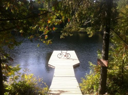
Marketing Summary

Of interest to both visitors and locals, Secret Lakes of Victoria answers a need articulated by the market
that has not yet been answered. This is a useful and timeless book that that builds on the proven
success of other guidebooks for the area and is of interest to a very broad audience.

What makes this book unique?

Secret Lakes of Victoria, BC is unique because it:

    •   contains unique, timeless information:
            o practical advice (where to take families, where to go swimming, fishing, hiking)
            o natural features (what to look for, unique flora & fauna, interconnected watersheds)
            o historical insight (land acquisition, land use, names and trivia)
    •   has minimal competition - no other book on the market covers the lakes of Victoria,
    •   builds on success of similar guidebooks for the Victoria area,
    •   uses a wide variety of sources to provide a significant contribution to the body of knowledge of
        the nature and history of the Victoria area,
    •   contains detailed maps and elegant photographs
    •   uses top 5 lists to communicate to specific segments of the audience

How does it compare to similar books?

There are currently successful guide books covering different aspects of the Victoria Area from the best
places to walk a dog the locations and history of the benches of the city, to a Naturalist’s Guide to the
Victoria Region. All of these books have gone on to publish a second edition.

The most similar book for comparison is likely the Secret Beaches series by Theo Dombrowski, published
by Heritage House Publishing. Priced at $26.95, there are three books in this series currently on the
market, with two more on the way. It’s safe to say that this series is a success.

So how does Secret Lakes of Victoria compare to the Secret Beaches series?

Secret Lakes differs itself because:

    •   A lake offers more activities than a beach, such as swimming, boating, fishing and hiking
    •   Secret Lakes goes beyond “how to get there” with history and natural features
    •   The maps in Secret Lakes are more useful and contain more features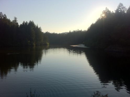
• The layout of Secret Lakes is more readable for quick reference
• Secret Lakes fits as well in a glove box as it does on a coffee table
Why this book will be a success?
Secret Lakes of Victoria, BC will become a timeless success because it:
• covers a specific topic of interest to a broad audience (visitors and locals)
• contributes to knowledge of the history and nature of this area
• covers a timeless topic – these lakes are not going anywhere
• contains information not found in any other publication
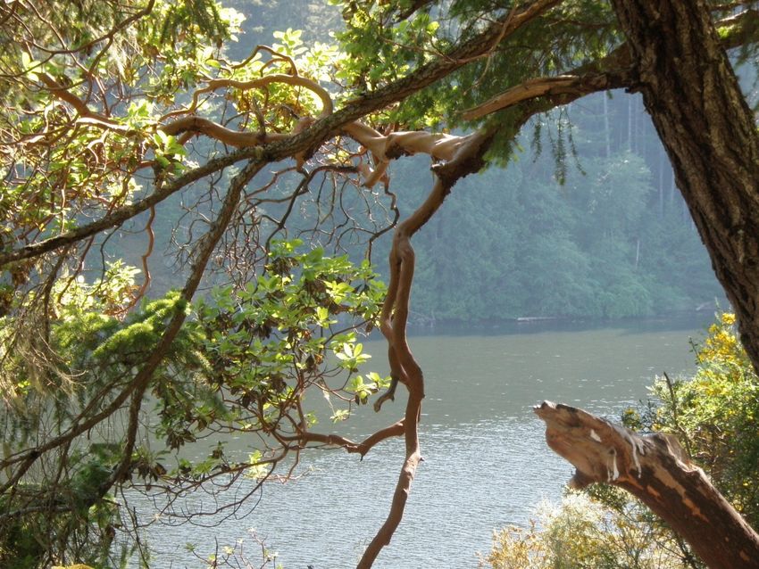
Photographs and Maps
Photographs
A few sample photographs taken by the author are included for reference. The author has been in
contact with other professional photographers, municipal governments and non-profits who are also
willing to share their work.
Matheson Lake Glinz Lake Thetis LakeMaps
A contract resource has been engaged to create maps for the book. The person creating these maps has
previously self-published a successful guide to mountain biking on Vancouver Island, and has an intimate
knowledge of trails around lakes which are not found on maps issued by organisations such as the CRD.
A sample map for Matheson Lake is below.
Biographical Information
I am currently employed as a Senior Information Architect with the Province of British Columbia, and
have been writing about my passion, the lakes of the Victoria area, in the evenings and weekends. A bit
more about my background and areas of expertise:
• Freelance Radio Producer for CBC Radio One (OutFront)
• Community Radio Producer and Host (CJSR FM88.5)
• User Experience Designer – strong understanding of visual
design, layout, plain language writing
• Project Management Professional – holds a valid PMP
accreditation
• Speaker at International Conferences (Information
Architecture Summit 2012)
• Exhibited Photographer – shown several series of film
photographs at different cafes in Victoria
• Local – Resident of Victoria for 7 yearsTable of Contents Part One: Introduction Overall Map Introduction Disclaimer Top Five: The Best of the Lakes around Victoria. Swimming Beaches Hiking Fishing Paddling Motorized Boats Children and Families Dogs Bike Rides Accessibility Learning About Nature Lakes 101 How does a lake get made? Who owns a lake? How does a lake get its Name? What makes a lake warm? Lake Ecosystems Victoria's Watersheds First Nations A Brief History of Victoria’s Water Supply Your Responsibilities
Part Two: The Lakes

Victoria
   Good Acre
       Arbour
   Fountain
       Rose

Saanich
   Swan
   Elk/Beaver
   Prospect
   Killarney
   Maltby

Highlands
   Thetis
   Prior
   Durrance
   Eagles
   Heal
   Pease
   Fork
   Mary

Langford
   Langford
   Glen
   Florence

Metchosin
  Blinkhorn
  Quarantine

Goldstream
   Glinz

Sooke
   Matheson
   Kemp
Sooke Hills Wilderness Grass Sheilds Crabapple Malahat Spectacle Epilogue
Sample Chapters

The text for this book is currently being edited by a freelance professional.

Each lake will contain:

    •   A map
    •   A table of basic information (swimming, fishing, facilities etc)
    •   Directions by car
    •   1-5 pages descriptive text & history
    •   1-3 photos (including historical images)
    •   1-2 'Did you know' style info boxes

The following selected lakes are included for sample purposes only and are a ‘first cut’ – these have not
been edited by either the author or the contract resource.
Florence Hidden behind a busy intersection of the TransCanada Highway, Florence Lake is virtually unknown to both visitors and locals alike. The lake offers views and fishing year around, with swimming opportunities in the summer and a colourful display of leaves in the fall. Skirt Mountain can be seen to the northwest. The Strachan trail provides easy access and a pleasant walk around the east and southern sides of the lake, with boardwalks and viewing points throughout. Aside from providing calming views, the trail also provides numerous places to fish from the short, and there is also a boat launch on the north shore for small boats. While on the trail be sure not to miss the boardwalk between Savory and Brock roads on the south end of the lake. Raised well above ground, this boardwalk provides an opportunity to examine some of the surrounding trees, hanging moss from a different perspective. Keep an eye out for song birds and small critters below while you admire the panoramic view of the lake. History There is some debate about who Florence Lake was named for. While Geo BC’s registry of Geographic Names states that the lake was named after Florence Isabella Langford, Captain Langford’s fifth daughter, other local historians believe it was named after other early settlers in the area, Henry and Florence Dumbleton. Savory Road takes its name from the Savory family, who grew and sold vegetables in the Fernwood area of Victoria. In 1910 business was growing so they bought 200 acres of land in Langford to expand their operations. The first Langford Gun Club was then established on their property a few years later. Did you know? Unconfirmed local lore tells the story of a piano at the bottom of Florence Lake. Houses were built on the west side of the lake before there were roads to them, meaning the only way to transport things such as furniture to them was by boat. Apparently one owner tried to bring a piano to their home, and lost the piano in the lake when the boat capsized. If this story is true the piano is likely still there.
Elk/Beaver

The largest lake in the area, Elk Lake is often a visitor’s first impression of Vancouver Island as its
sparkling blue waters are glimpsed from the highway en route to Victoria. Its size and accessibility
ensure that Elk Lake has something to offer everyone.

Elk and Beaver Lakes started as two lakes that were joined in 1895 – the name of Elk/Beaver Lake Park
serving as a reminder that this body of water was once two separate lakes. The lake & surrounding
wetlands attract birds such as mergansers, buffleheads, mallards, geese and eagles, and the vegetation
along the shoreline provides homes for river otter and painted turtles.

Elk Lake is also one of the premier places to fish in the area. The lake is stocked each year with
catchable Rainbow Trout and is known for having a healthy population of 3-4 pound Smallmouth Bass.
Many anglers have taken up the sport of fly-fishing for these feisty fish at Elk/Beaver Lake.

Hamsterly Beach on the north end is a large, car accessible sand beach that gets plenty of sunshine and
is perfect for swimmers with picnickers. Beaver Beach also offers access to the lake on the south side.

The easy trail around the lake takes about 2.5 hours to complete and leads through forests of Douglas
Fir and Western Red Cedar. Watch out for Bald eagles and Osprey hunting for fish in the lake.

Being the largest lake in the area, Elk Lake is naturally a favourite for rowers. A variety of rowing
programs are offered for athletes of all ages by the Victoria City Rowing Club at the Victoria Rowing
Society boathouse. Also watch for regattas hosted by organizations such as UVIC’s rowing club.

Elk Lake is also known for its polar bear swims that take place on New Year’s Day each year. Talk about
getting a fresh start!

History

At one time Elk Lake served as Victoria’s primary water supply. In 1864 the Spring Ridge Water
Company laid log pipes to transport water from the Elk Lake to downtown Victoria. Families would
either go downtown to fill their water barrels, or the water would be delivered to them by horse and
wagon. In 1875 water from Elk Lake was piped to Victoria homes.

The level of Beaver Lake was raised in 1895 to connect it with Elk Lake, thereby increasing capacity for
water supply.

The double track trail on the west side of the lake used to be part of a railway that offered service
between Victoria and Sidney in 1894 – 1919.
Did you know?

The Beaver Lake Store currently at 4808 West Saanich Road started as a small confectionary on the east
side of the road, but cousins Eulalie and Marie Harrison literally hauled the building across the street
when their landlord raised the rent. They later rented and purchased the property where the store
currently stands.
Killarney

Killarney Lake has two very distinct sides to it, and people approaching it from different directions will
see a very different lake.

Approaching from the south by the trail from Meadowbrook Road is a unique, unforgettable experience.
The rural road leads through farms and cabins and simply becomes a trail at the end. There is no
parking at the trailhead so the best access is by bike or on foot.

After a 15 – 20 minute hike with some steep hills you come up to a picture perfect clearing on the shore
of Killarney Lake with a rock perfect for a picnic, and easy walk-in access to the lake below. It is quite a
beautiful place.

Yet someone approaching from the North will see a different lake. While most of the shoreline of
Killarney Lake is part of Mount Work Park (a favourite for mountain bikers), a small portion of the
shoreline on Killarney Lake is private property. To further complicate things, a BC Hydro right-of-way
borders the lake on its xx side, not to mention the Hartland landfill that is directly to the north.

Yet despite its proximity to the landfill and power lines the lake is full of life, and is a treasure to the
people that know about it.

History

Originally, it appears that Killarney Lake was known as “Surprise Lake.” A mapping error however
mislabelled it as “Mud Lake”, a name that was intended for a pond nearby.

In a 1928 letter to the Geographic Board the owner of land around the lake, Herbert F. Shade stated that
he had changed the name to “Killarney” but as there were 2 other lakes with the same name could his
be listed as “Lake Kilarney” – removing an ‘l’ from the name.

The Geographic Board rejected the request for the spelling change, and suggested “Shade Lake” instead.
Mr. Shade declined the offer out of respect for his business partner, and the lake today continues to be
known as “Killarney Lake.”
Fork

While Fork Lake isn’t much for swimming, it is an ideal place to connect with the natural world. In
particular, pay attention to the ground on your visit to Fork Lake, where you’ll find a fascinating variety
of fungi, deep mosses, and wildflowers. Be sure to stay on the trail of course, as human feet are
unaware of their own power and are apt to destroy these beauties without realizing what they are
trampling over.

While residences are found on the east side of Fork Lake, the west side falls within the Mount Work
Regional Park, and serves as the trailhead for a hike up to the summit of Mount Work. While you may
catch a glimpse of the lake now and then from the trail, actual access to the water is severely limited
and requires a wading through bushes.

Following the trail from the parking lot at Munn Road around the west shore of Fork Lake you will reach
a ‘fork’ in the path – continuing to the right leads up to the summit of Mount Work, and another largely
unknown historical feature, Corry Road, is to the left.

Corry Road was built in the 1920s to connect families living at Fork Lake with their neighbours living at
Third Lake. and connects Munn Road to Ross Durrance Road

Today the road falls mostly within public rights of way (approximately 300 meters of the road are on
private land) and offers an accessible and relatively easy trail within a biologically complex and diverse
ecosystem.

The largely undisturbed second-growth forest Corry Road passes through enables visitors to appreciate
the beauty of the natural world, and is used for activities such as photography, bird-watching, and
outdoor art creation.

History

Built in 1910 the Fork Lake Ditch is considered a symbol of the pioneer drive to not only survive but also
to move beyond subsistence.

Found on the west side of the lake, the ditch was dug and blasted by an early property owner named
Frank Gregory. Gregory had determined that by lowering the level of the lake he would be able to
create more land for grazing for his livestock.

And indeed he was right – the ditch he created allowed water from Fork Lake to drain into Fizzle Lake to
the south, reducing the level of Fork Lake by nearly 10 feet and creating 7000 square meters of new land
for his livestock.
You can also read